
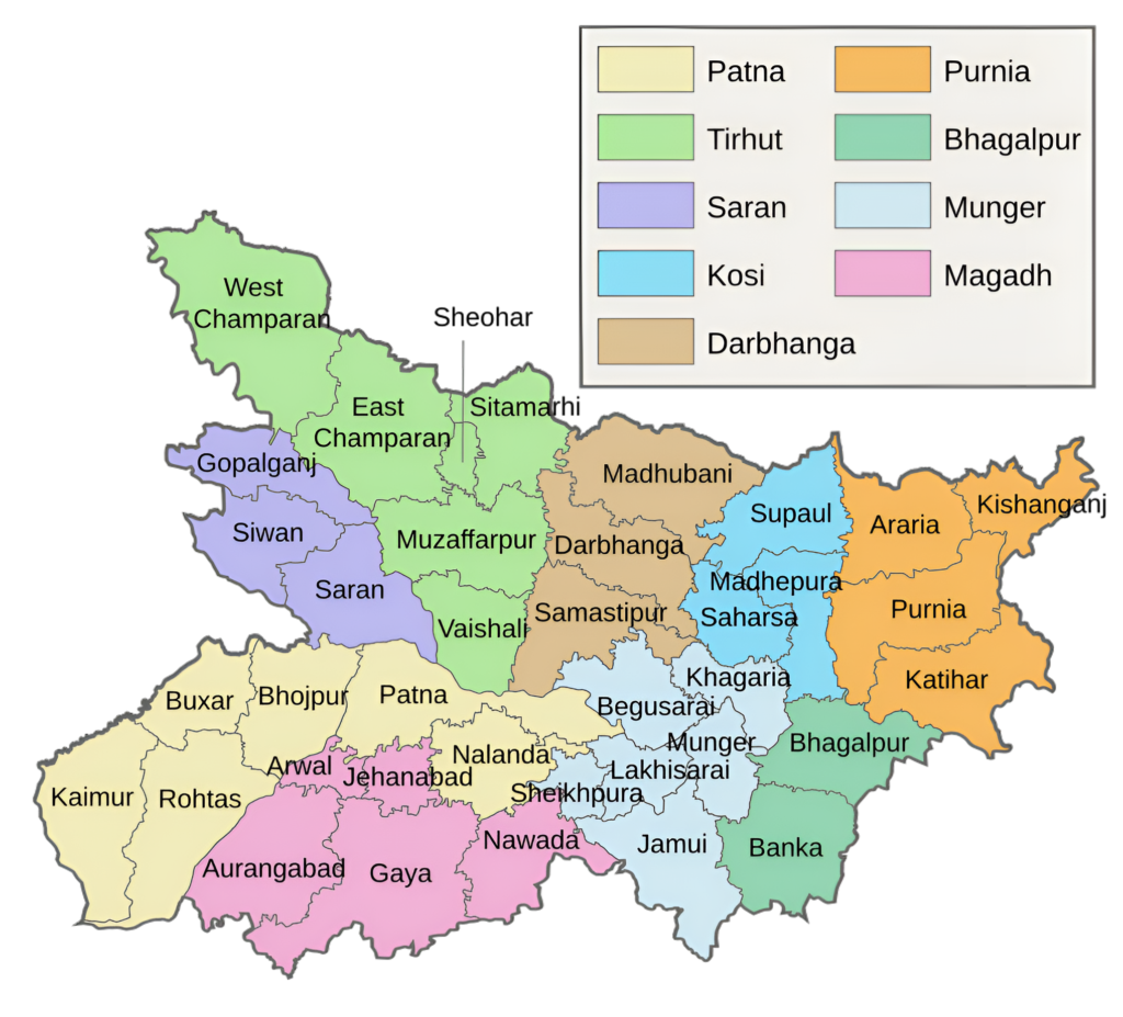
Tirhut Division and Its Districts of Bihar
Overview
Tirhut Division or Tirhut Commissionary is one of the largest among nine administrative divisions, located in the northern part of the Bihar state, India. The Division’s administrative headquarter located at Muzaffarpur District, ‘The Land Of Leechi’ was created in 1908. The division consisting of six districts, namely Muzaffarpur, West Champaran (headquartered at Bettiah), East Champaran (headquartered at Motihari), Vaishali (headquartered at Hajipur), Sitamarhi and Sheohar.
The administrative head of Tirhut Division is a Commissioner, a senior officer of the Indian Administrative Service (IAS). Each district has its own historically, culturally, and economically significant, known for its fertile land, cultural heritage, and pivotal role in the development of Bihar.
The Tirhut Division is spread over 17,141 sq km area, population is approx 2,14,10,544 and Literacy is 60.81%. Moreover, the Tirhut Division has 18 subdivisions, 99 blocks, 1788 Gram Panchyat & 1572 villages.
Muzaffarpur District
Tirhut Division Headquarter Muzaffarpur district is the center of several big and Industries. Specifically, the Prabhat Zarda Factory, Bharat Wagon and Engineering Ltd., units of Leather Development Corporation, Muzaffarpur Dairy, a unit of the Bihar State Dairy Corporation are the major industries located in Muzaffarpur town and its periphery. Consequently, the above industries have generated considerable employment and have also been helpful in establishing a number of small industries including a few cottage industries.
East & West Champaran
The Champaran Satyagraha of 1917 was the first satyagraha movement led by Mahatma Gandhi in British India and is, therefore, considered a historically important rebellion in the Indian independence movement. This was the beginning of the new phase in the fight for independence. Later on, Bapu came here many times. Interestingly, the British had made Champaran an independent unit in 1866; however, in 1971 it was divided into Eastern and Western Champaran.
Vaishali District
District Vaishali of Tirhut Division was established as a republic by the 6th century BC, this occurred prior to the birth of Gautama Buddha in 563, making it the world’s first republic. Being the birthplace of the last Jain “Thirthankara” Lord Mahavir gives Vaishali a very special place in history. The founder of Buddhism, Gautam Buddha delivered his last sermon and announced his Parinirvana (attainment of enlightment) on this holy soil.
Sitamarhi District
The district Sitamarhi of Tirhut Division was carved out of Muzaffarpur district on 11th December 1972. Sitamarhi is a sacred place in Hindu mythology. In Fact, Its history goes back to Treta Yug. According to legend, Goddess Sita, the wife of Lord Rama sprang to life out of an earthern pot, when Raja Janak was ploughing the field somewhere near Sitamarhi to impress upon Lord Indra for rain. It is said that Raja Janak excavated a tank at the place where Sita emerged and after her marriage set up the stone figures of Rama, Sita and Lakshman to mark the site. This tank is known as Janaki-kund and is south of the Janaki Mandir.
Sheohar District
Sheohar is the smallest district of Tirhut Division. Previously it was a Subdivision of Sitamarhi district. It separated from sitamarhi on October 6, 1994.
Key Facts About Tirhut Division
- Country:
 India
India - State:
 Bihar
Bihar - Established: 1908
- Area: 17,141 km2 (6,618 sq mi)
- Coordinates: 26.07°N 85.45°E
- Official Website: Tirhut
- Division Headquarters: Muzaffarpur
- Commissioner: Saravanan Meena, IAS
- Population (2011): 21,410,544
- Number of Districts: 6
- Subdivisions: 20
- Muzaffarpur Sadar, Katra, Aurai, Minapur, Areraj, Chakia, Motihari, Pakaridayal, Raxaul, Sikarahana, Bettiah, Bagaha, Narkatiaganj, Sheohar, Sitamarhi Sadar, Pupri, Belsand, Hajipur, Mahnar, Mahua
- Blocks: 99
- Gram Panchyat: 1788
- Villages: 1572
- Rivers: Bagmati, Burhi Gandak, Gandaki, Ganges, Lakhandei
- Geography:
- Located in northern Bihar, bordered by Nepal to the north.
- The division is traversed by major rivers like the Ganga, Gandak, and Bagmati.
- Freedom Fighters:
- Khudiram Bose, Maghfoor Ahmad Ajazi, Manzoor Ahsan Ajazi, Bhagwan Das, Juba Sahni, Raj Kumar Shukla, Ramdayalu Singh, Mathura Singh, Binda Babu and Mahesh Babu
- Transports:
- NH 19, NH 57, NH 77, NH 102, NH 103, NH 227, NH 527, NH 527D, NH 727.
- Barauni–Gorakhpur, Raxaul and Jainagar lines.
- Barauni–Samastipur–Muzaffarpur–Hajipur line.
- Muzaffarpur–Gorakhpur line (via Hajipur, Raxaul and Sitamarhi).
- Muzaffarpur–Gorakhpur main line.
- Muzaffarpur–Hajipur section.
- Samastipur–Muzaffarpur section.
- Barauni–Samastipur section.
- Railway Stations:
- Desari, Hajipur Junction, Muzaffarpur Junction, Narkatiaganj Junction, Sonpur Junction.
- Lok Sabha constituencies:
- Hajipur, Muzaffarpur, Paschim Champaran, Purvi Champaran, Sheohar, Sitamarhi, Vaishali, Valmiki Nagar.
- Former Lok Sabha constituencies: Bagaha, Bettiah, Motihari
- Former Vidhan Sabha constituencies:
- Dhanaha, Shikarpur, Adapur, Ghorasahan, Majorganj, Sonbarsha, Pupri, Jandaha.
Districts of Tirhut Division (Administrative Structure)
Tirhut Division is one of the largest divisions in Bihar, consisting of six districts:
1. Muzaffarpur District:
- Area: 3,173 km2 (1,225 sq mi)
- Population (2011): 4,801,062
- Literacy Rate: 85%
- District Headquarters: Muzaffarpur city.
- Gram Panchayats: 373
- Villages: 1811
- No. of Blocks: 16
- Police Station: 42
- No. of Subdivision: 4 (Muzaffarpur Sadar, Katra, Aurai, Minapur)
- Municipal corporation (Nagar Nigam): 1 (Muzaffarpur)
- Municipal Council (Nagar Parishad): 3 (Kanti, Motipur, Sahebganj)
- Nagar Panchayats: 7 (Sakra, Minapur, Baruraj, Madhopur Susta, Turki, Muraul, Saraiya)
- Vidhan Sabha constituencies: 11
- Gaighat, Aurai, Minapur, Bochahan, Sakra, Kurhani, Muzaffarpur, Kanti, Baruraj, Paroo, Sahebganj.
- Lok Sabha constituency: 2 (Muzaffarpur, Vaishali)
- Rivers: Gandak, Budhi Gandak, Bagmati and Lakhandei.
- Key Features:
- Known as the “Land of Litchis”, famous for its Shahi Litchis.
- A major commercial and educational hub in northern Bihar.
- Home to Baba Garibnath Temple and Jubba Sahni Park.
- Significance: Central to the division’s economy, trade, and education.
- Official Website: muzaffarpur.nic.in
2. Vaishali District:
- Area: 2,036 km2 (786 sq mi)
- Population (2011): 3,495,021
- Literacy Rate: 66.60%
- District Headquarters: Hajipur.
- Gram Panchayats: 290
- Villages: 1414
- No. of Blocks: 16
- Police Station: 30
- No. of Subdivision: 3 (Hajipur, Mahnar, Mahua)
- Municipal Council (Nagar Parishad): 1 (Hajipur)
- Nagar Panchayats: 2 (Mahnar, Lalganj)
- Vidhan Sabha constituencies: 8
- Hajipur, Lalganj, Vaishali, Mahua, Raja Pakar, Raghopur, Mahnar, Patepur.
- Lok Sabha constituency: 2 (Hajipur, Vaishali)
- Key Features:
- Historically significant as the birthplace of Lord Mahavira, the founder of Jainism.
- The site of the world’s first republic (Vajji Sangha) in ancient India.
- Tourist attractions include the Ashokan Pillar and Buddha Stupa.
- Significance: A historical and spiritual center with a rich cultural heritage.
- Official Websites: vaishali.nic.in
3. Sitamarhi District:
- Area: 2,185 km2 (844 sq mi)
- Population (2011): 3,423,574
- Literacy Rate: 53.53%
- District Headquarters: Sitamarhi town.
- Gram Panchayats: 258
- Villages: 845
- No. of Blocks: 17
- Police Station: 21
- No. of Subdivision: 3 (Sitamarhi Sadar, Pupri, Belsand)
- Municipal council (Nagar Parishad): Sitamarhi
- Nagar Panchayats: 4
- Vidhan Sabha constituencies: 8
- Riga, Bathnala, Parihar, Sursand, Bajpatti, Sitamarhi, Runnisaidpur, Belsand.
- Lok Sabha constituency: 1 (Sitamarhi)
- Key Features:
- Believed to be the birthplace of Goddess Sita, as per Hindu mythology.
- Janaki Temple in Sitamarhi is a major pilgrimage site.
- Rich agricultural land producing paddy, wheat, and pulses.
- Significance: A district with religious importance and strong cultural ties.
- Official Website: sitamarhi.nic.in
4. Sheohar District:
- Area: 349 km2 (135 sq m
- Population: 656,246
- Literacy Rate: 72%
- District Headquarters: Sheohar town.
- Gram Panchayats: 53
- Villages: 203
- No. of Subdivision: 1 (Sheohar)
- No. of Blocks: 5 (Sheohar, Tariyani, Piprahi, Dumri-katsari, Purnahiya)
- Police Station: 12
- Municipal council (Nagar Parishad): 1 (Sheohar)
- Vidhan Sabha constituencies: 1 (Sheohar)
- Lok Sabha constituency: 1 (Sheohar)
- Key Features:
- Smallest district in Tirhut Division.
- Known for its scenic beauty and fertile plains.
- Primarily an agrarian economy with paddy and sugarcane cultivation.
- Significance: A developing district with a focus on agriculture.
- Official Website: sheohar.nic.in
5. East Champaran (Motihari):
- Area: 3,968 km2 (1,532 sq mi)
- Population (2011): 5,099,371
- Literacy Rate: 55.79%
- District Headquarters: Motihari.
- Gram Panchayats: 405
- Villages: 1344
- No. of Blocks: 27
- Police Station: 50
- No. of Subdivision (Tehsil): 6 (Areraj, Chakia, Motihari, Pakaridayal, Raxaul, Sikarahana)
- Municipal council (Nagar Parishad): 2 (Motihari, Raxaul)
- Nagar Panchayats: 7 (Areraj Nagar, Dhaka, Chakiya, Kesariya, Mehsi, Pakaridayal, Sugauli
- Vidhan Sabha constituencies: 12
- Raxaul, Sugauli, Narkatiya, Harsidhi, Govindganj, Kesaria, Kalyanpur, Pipra, Madhuban, Motihari, Chiraia, Dhaka.
- Lok Sabha constituency: 3 (Purvi Champaran, Paschim Champaran, Sheohar)
- Key Features:
- The site of Champaran Satyagraha, Mahatma Gandhi’s first movement in India.
- Tourist attractions: Gandhi Memorial, Kesariya Stupa (largest Buddhist stupa in the world).
- Fertile land producing sugarcane, maize, and pulses.
- Significance: A historical and agricultural hub of Bihar.
- Official Website: eastchamparan.nic.in
6. West Champaran (Bettiah):
- Area: 5,228 km2 (2,019 sq mi)
- Population (2011): 3,935,042
- Literacy Rate: 58.06%
- District Headquarters: Bettiah.
- Gram Panchayats: 303
- Villages: 1483
- No. of Blocks: 18
- Police Station: 19
- No. of Subdivision (Tehsil): 3 (Bettiah, Bagaha, Narkatiaganj)
- Municipal corporation (Nagar Nigam): 1 (Bettiah)
- Municipal Council (Nagar Parishad): 3 (Ramnagar, Narkatiaganj, Bagaha)
- Nagar Panchayats: 3 (Chanpatia, Lauriya, Machhargawan)
- Vidhan Sabha constituencies: 9
- Valmiki Nagar, Ramnagar, Narkatiaganj, Bagaha, Lauriya, Nautan, Chanpatia, Bettiah, Sikta.
- Lok Sabha constituency: 2 (Paschim Champaran, Valmiki Nagar)
- Key Features:
- Known for the Valmiki National Park, which is home to Bengal tigers and other wildlife.
- Rich in natural beauty with forests and rivers.
- Historically linked to the Bettiah Raj (a prominent zamindari estate).
- Significance: A district of ecological and historical importance.
- Official Website: westchamparan.nic.in
Geographical Overview
- Location: Tirhut Division is situated in the northern part of Bihar, bordering Nepal to the north and the Ganges River to the south. It lies in the Mithila region, renowned for its distinct culture.
- Rivers: Key rivers include the Gandak, Bagmati, and Burhi Gandak, which irrigate the fertile plains but also cause seasonal flooding.
- Climate: The region experiences a humid subtropical climate, with hot summers, monsoon rains, and mild winters.
Historical Significance
- Ancient History: Tirhut has been an integral part of the Mithila region, historically associated with the Videha Kingdom and the ancient capital of Janakpur (now in Nepal). The area has deep connections to Hindu mythology, particularly the Ramayana, as the birthplace of Sita.
- Medieval Era: During the medieval period, the region was a center of governance and trade under various empires, including the Mughals.
- Freedom Movement: Tirhut played a pivotal role in India’s independence movement. Mahatma Gandhi’s first Satyagraha in Champaran (1917) against indigo plantations was a landmark event.
Cultural Significance
- Maithili Culture: As part of the Mithila region, Tirhut is known for its Maithili language, literature, and art, including the globally renowned Madhubani paintings.
- Festivals: Major festivals include Chhath Puja, Durga Puja, and Makar Sankranti, celebrated with fervor.
- Religious Sites:
- Vaishali: A key Buddhist and Jain pilgrimage site, associated with Lord Mahavira and Gautama Buddha.
- Sitamarhi: Believed to be the birthplace of Goddess Sita.
Economy
- Agriculture: The fertile Gangetic plains make Tirhut one of the most agriculturally productive regions in Bihar. Major crops include rice, wheat, maize, sugarcane, and lentils.
- Sugar Industry: Tirhut has historically been a hub for sugar production, with several sugar mills located in the region.
- Livelihood: Apart from agriculture, people engage in fisheries, handloom weaving, and livestock rearing. Migrant remittances also play a significant role in the local economy.
- Trade and Commerce: Muzaffarpur is a major trade center, known for its litchi production, which is exported worldwide.
Education and Institutions
- Key Institutions:
- Babasaheb Bhimrao Ambedkar Bihar University (BRABU): Located in Muzaffarpur, it is a leading higher education institution in the division.
- Dr. Rajendra Prasad Central Agricultural University: Situated in Pusa, Samastipur (near Tirhut), it is a premier institution for agricultural research and education.
- Traditional Learning: Tirhut has historically been a center for Sanskrit and Vedic education.
Transportation and Connectivity
- Railways: Tirhut Division is well-connected by the Indian Railways network, with major railway stations like Muzaffarpur, Bettiah, and Sitamarhi.
- Roadways: National and state highways connect the region to Patna and other parts of Bihar. However, road infrastructure in rural areas needs improvement.
- Airport: Muzaffarpur has a small airstrip, but most air travelers rely on Patna’s Jay Prakash Narayan International Airport.
- Proximity to Nepal: Border towns like Raxaul serve as important trade and transit points between India and Nepal.
Tourism
Tirhut Division is rich in historical and religious landmarks:
- Vaishali: Known as the birthplace of Lord Mahavira and an important Buddhist site. Attractions include the Ashokan Pillar and the ruins of ancient monasteries.
- Sitamarhi: Associated with the Ramayana and the birthplace of Sita.
- Kesariya Stupa (East Champaran): One of the largest Buddhist stupas in the world.
- Champaran: A key destination for Gandhian heritage, with sites related to the Champaran Satyagraha.
- Muzaffarpur: Famous for its Shahi litchis and local cuisine.
Challenges
- Flooding: Rivers like the Bagmati and Gandak cause frequent flooding, disrupting agriculture and livelihoods.
- Infrastructure: While urban centers like Muzaffarpur are developing, rural areas face challenges in infrastructure, healthcare, and education.
- Economic Migration: Limited industrialization and job opportunities lead to significant outmigration to other parts of India.
Key Highlights
- Cultural Hub: Tirhut is a vibrant center of Mithila’s Maithili culture, language, and traditions.
- Agricultural Prosperity: Known as the “rice bowl” of Bihar, with high agricultural productivity.
- Historical Importance: A region steeped in history, from the Ramayana era to India’s independence movement.
- Tourism Potential: Home to world-renowned Buddhist, Jain, and Hindu pilgrimage sites, attracting domestic and international visitors.
Conclusion
Tirhut Division stands out as a historically rich and culturally vibrant region of Bihar. It has immense potential for development in agriculture, tourism, and trade, leveraging its historical legacy and proximity to Nepal. Addressing challenges like flooding and infrastructure gaps can further enhance its significance in Bihar’s growth and development. In particular, with districts like Vaishali and Champaran playing key roles in history as well as movements like Satyagraha, the division is central to Bihar’s heritage and development.
Would you like more details about any specific Topics on Bihar? Comment Below 😊
बिहार का तिरहुत प्रमंडल और उसके जिले
अवलोकन
तिरहुत प्रमंडल या तिरहुत कमिश्नरी भारत के बिहार राज्य के उत्तरी-भाग में स्थित 9-प्रशासनिक प्रमंडलों में से सबसे बड़ा है। प्रमंडल का प्रशासनिक मुख्यालय मुजफ्फरपुर जिले में स्थित है, जिसे ‘लीची की धरती’ कहा जाता है और इसकी स्थापना 1908 में हुई थी। इस प्रमंडल में छह-जिले शामिल हैं, अर्थात् मुजफ्फरपुर, पश्चिम चंपारण (बेतिया में मुख्यालय), पूर्वी चंपारण (मोतिहारी में मुख्यालय), वैशाली (हाजीपुर में मुख्यालय), सीतामढ़ी और शिवहर।
तिरहुत प्रमंडल का प्रशासनिक प्रमुख एक आयुक्त होता है, जो भारतीय प्रशासनिक सेवा (IAS) का एक वरिष्ठ अधिकारी होता है। प्रत्येक जिले का अपना ऐतिहासिक, सांस्कृतिक और आर्थिक रूप से महत्वपूर्ण स्थान है, जो अपनी उपजाऊ भूमि, सांस्कृतिक विरासत और बिहार के विकास में महत्वपूर्ण भूमिका के लिए जाना जाता है।
यह प्रमंडल 17,141 वर्ग किमी क्षेत्र में फैला हुआ है इसके अलावा, तिरहुत प्रमंडल में 18 अनुमंडल, 99 प्रखंड, 1788 ग्राम पंचायत और 1572 गांव हैं।
मुजफ्फरपुर जिला
तिरहुत प्रमंडल मुख्यालय मुजफ्फरपुर जिला कई बड़े और उद्योगों का केंद्र है। विशेष रूप से, प्रभात जर्दा फैक्ट्री, भारत वैगन एंड इंजीनियरिंग लिमिटेड, चमड़ा विकास निगम की इकाइयाँ, मुजफ्फरपुर डेयरी, बिहार राज्य डेयरी निगम मुजफ्फरपुर शहर और इसके आसपास स्थित प्रमुख उद्योग हैं। परिणामस्वरूप, उपरोक्त उद्योगों ने काफी रोजगार पैदा किया है और कुछ कुटीर उद्योगों सहित कई छोटे उद्योगों की स्थापना में भी सहायक रहे हैं।
पूर्वी और पश्चिमी चंपारण
1917 का चंपारण सत्याग्रह ब्रिटिश भारत में महात्मा गांधी के नेतृत्व में पहला सत्याग्रह आंदोलन था और इसलिए इसे भारतीय स्वतंत्रता आंदोलन में ऐतिहासिक रूप से महत्वपूर्ण विद्रोह माना जाता है। नतीजतन, यह स्वतंत्रता संग्राम के नए चरण की शुरुआत थी। आजादी के बाद बापू कई बार यहां आए। दिलचस्प बात यह है कि अंग्रेजों ने 1866 में चंपारण को एक स्वतंत्र इकाई बना दिया था, हालांकि 1971 में इसे पूर्वी और पश्चिमी चंपारण में विभाजित कर दिया गया।
वैशाली जिला
तिरहुत प्रमंडल का जिला वैशाली छठी शताब्दी ईसा पूर्व में एक गणराज्य के रूप में स्थापित हो चुका था; इसके अलावा, यह 563 में गौतम बुद्ध के जन्म से पहले हुआ था, जिससे यह दुनिया का पहला गणराज्य बन गया। इसके अलावा, अंतिम जैन “तीर्थंकर” भगवान का जन्मस्थान होने के नाते महावीर ने वैशाली को इतिहास में एक बहुत ही खास स्थान दिया है। इसके अलावा बौद्ध धर्म के संस्थापक गौतम बुद्ध ने अपना अंतिम उपदेश दिया और इसी पवित्र धरती पर अपने परिनिर्वाण (ज्ञान प्राप्ति) की घोषणा की।
सीतामढ़ी जिला
तिरहुत प्रमंडल का सीतामढ़ी जिला मुजफ्फरपुर जिले से अलग करके बनाया गया था 11 दिसंबर 1972 को। इसके अलावा, सीतामढ़ी हिंदू पौराणिक कथाओं में एक पवित्र स्थान है। वास्तव में, इसका इतिहास त्रेता युग से जुड़ा हुआ है। किंवदंती के अनुसार, भगवान राम की पत्नी सीता एक मिट्टी के बर्तन से जीवित हुई थी, जब राजा जनक ने उसे मार डाला था। सीतामढ़ी के पास कहीं भगवान इंद्र को बारिश के लिए राजी करने हेतु खेत जोत रहा था। परिणामस्वरूप, ऐसा कहा जाता है कि राजा जनक ने उस स्थान पर एक तालाब खुदवाया जहाँ सीता प्रकट हुई थीं और उनके विवाह के बाद उस स्थान को चिह्नित करने के लिए राम, सीता और लक्ष्मण की पत्थर की आकृतियाँ स्थापित कीं। परिणामस्वरूप, इस तालाब को जानकी-कुंड के नाम से जाना जाता है और जानकी मंदिर के दक्षिण में है।
शिवहर जिला
शिवहर तिरहुत प्रमंडल का सबसे छोटा जिला है। पहले यह सीतामढ़ी जिले का अनुमंडल था। अंततः 06-10-1994 को यह सीतामढ़ी से अलग हो गया।
तिरहुत प्रमंडल के बारे में मुख्य तथ्य
- देश: भारत
- राज्य: बिहार
- स्थापना: 1908
- आधिकारिक वेबसाइट: तिरहुत
- क्षेत्रफल: 17,141 किमी2 (6,618 वर्ग मील)
- निर्देशांक: 26.07°N 85.45°E
- प्रमंडल मुख्यालय: मुजफ्फरपुर
- संभागीय आयुक्त: सरवनन मीना, IAS
- जिलों की संख्या: 6 (मुजफ्फरपुर, पश्चिम चंपारण, पूर्वी चंपारण, वैशाली, सीतामढ़ी और शिवहर)
- जनसंख्या (2011): 21,410,544
- उपखंड: 20
- ब्लॉक: 99
- ग्राम पंचायत: 1788
- गाँव: 1572
- नदियाँ: बागमती, बूढ़ी गंडक, गंडकी, गंगा, लखनदेई।
- भूगोल:
- उत्तरी बिहार में स्थित है, जिसकी सीमा उत्तर में नेपाल से लगती है।
- यह विभाजन गंगा, गंडक और बागमती जैसी प्रमुख नदियों से होकर गुजरता है।
- स्वतंत्रता सेनानी:
- खुदीराम बोस, मग़फ़ूर अहमद अजाज़ी, मंज़ूर अहसन अजाज़ी, भगवान दास, जुबा साहनी, राज कुमार शुक्ला, रामदयालु सिंह, मथुरा सिंह, बिंदा बाबू और महेश बाबू
- परिवहन:
- एनएच 19, एनएच 57, एनएच 77, एनएच 102, एनएच 103, एनएच 227, एनएच 527, एनएच 527डी, एनएच 727
- बरौनी-गोरखपुर, रक्सौल और जयनगर लाइनें
- बरौनी-समस्तीपुर-मुजफ्फरपुर-हाजीपुर लाइन
- मुजफ्फरपुर-गोरखपुर लाइन (हाजीपुर, रक्सौल और सीतामढी के माध्यम से)
- मुजफ्फरपुर-गोरखपुर मुख्य लाइन
- मुजफ्फरपुर-हाजीपुर खंड
- समस्तीपुर-मुजफ्फरपुर खंड
- बरौनी-समस्तीपुर खंड
- रेलवे स्टेशन:
- देसारी, हाजीपुर जंक्शन, मुजफ्फरपुर जंक्शन, नरकटियागंज जंक्शन, सोनपुर जंक्शन
- लोकसभा निर्वाचन क्षेत्र:
- हाजीपुर, मुजफ्फरपुर, पश्चिम चंपारण, पूर्वी चंपारण, शिवहर, सीतामढी, वैशाली, वाल्मिकी नगर
- पूर्व लोकसभा क्षेत्र: बगहा, बेतिया, मोतिहारी
- पूर्व विधान सभा क्षेत्र:
- धनहा, शिकारपुर, आदापुर, घोड़ासहन, मेजरगंज, सोनबर्षा, पुपरी, जंदाहा
तिरहुत प्रमंडल के जिले
तिरहुत प्रमंडल बिहार के सबसे बड़े प्रमंडलों में से एक है, जिसमें छह जिले शामिल हैं:
1. मुजफ्फरपुर:
- क्षेत्रफल: 3,173 km2 (1,225 वर्ग मील)
- जनसंख्या (2011): 4,801,062
- साक्षरता दर: 85%
- जिला मुख्यालय: मुजफ्फरपुर शहर.
- ग्राम पंचायतें: 373
- गाँव: 1811
- ब्लॉकों की संख्या: 16
- पुलिस स्टेशन: 42
- नगर निगम: 1 (मुजफ्फरपुर)
- उपखंड की संख्या: 2
- नगर परिषद: 3 (कांटी, मोतीपुर, साहेबगंज)
- नगर पंचायत: 7 (सकरा, मीनापुर, बरुराज, माधोपुर सुस्ता, तुर्की, मुरौल, सरैया)
- विधान सभा क्षेत्र: 11
- गायघाट, औराई, मीनापुर, बोचहां, सकरा, कुरहनी, मुजफ्फरपुर, कांटी, बरूराज, पारू, साहेबगंज।
- लोकसभा क्षेत्र: 2 (मुजफ्फरपुर, वैशाली)
- नदियाँ: गंडक, बूढ़ी गंडक, बागमती और लखनदेई।
- मुख्य विशेषताएँ:
- लीची की भूमि के रूप में जाना जाता है, जो अपनी शाही लीची के लिए प्रसिद्ध है।
- उत्तरी बिहार में एक प्रमुख वाणिज्यिक और शैक्षणिक केंद्र।
- बाबा गरीबनाथ मंदिर और जुब्बा सहनी पार्क का घर।
- महत्व: प्रमंडल की अर्थव्यवस्था, व्यापार और शिक्षा के लिए केंद्रीय।
- आधिकारिक वेबसाइट: muzaffarpur.nic.in
2. वैशाली:
- क्षेत्रफल: 2,036 km2 (786 वर्ग मील)
- जनसंख्या (2011): 3,495,021
- साक्षरता दर: 66.60%
- जिला मुख्यालय: हाजीपुर.
- ग्राम पंचायतें: 290
- गांव: 1414
- ब्लॉकों की संख्या: 16
- पुलिस स्टेशन: 30
- अनुमण्डल की संख्या: 3 (हाजीपुर, महनार, महुआ)
- नगर परिषद: 1 (हाजीपुर)
- नगर पंचायत: 2 (महनार, लालगंज)
- विधान सभा क्षेत्र: 8
- हाजीपुर, लालगंज, वैशाली, महुआ, राजा पाकर, राघोपुर, महनार, पातेपुर।
- लोकसभा क्षेत्र: 2 (हाजीपुर, वैशाली)
- मुख्य विशेषताएँ:
- जैन धर्म के संस्थापक भगवान महावीर की जन्मस्थली के रूप में ऐतिहासिक रूप से महत्वपूर्ण।
- प्राचीन भारत में विश्व के पहले गणराज्य (वज्जि संघ) का स्थल।
- पर्यटक आकर्षणों में अशोक स्तंभ और बुद्ध स्तूप शामिल हैं।
- महत्व: समृद्ध सांस्कृतिक विरासत वाला एक ऐतिहासिक और आध्यात्मिक केंद्र।
- आधिकारिक वेबसाइट: vaishali.nic.in
3. सीतामढ़ी:
- क्षेत्रफल: 2,185 km2 (844 वर्ग मील)
- जनसंख्या (2011): 3,423,574
- साक्षरता दर: 53.53%
- जिला मुख्यालय: सीतामढी शहर।
- ग्राम पंचायतें: 258
- गाँव: 845
- ब्लॉकों की संख्या: 17
- पुलिस स्टेशन: 21
- उपखंड की संख्या: 3
- नगर परिषद: 1 (सीतामढ़ी)
- नगर पंचायतें: 4
- विधान सभा क्षेत्र: 8
- रीगा, बथनाला, परिहार, सुरसंड, बाजपट्टी, सीतामढी, रून्नीसैदपुर, बेलसंड।
- लोकसभा क्षेत्र: 1 (सीतामढ़ी)
- मुख्य विशेषताएं:
- हिंदू पौराणिक कथाओं के अनुसार, इसे देवी सीता का जन्मस्थान माना जाता है।
- सीतामढ़ी में जानकी मंदिर एक प्रमुख तीर्थ स्थल है।
- धान, गेहूं और दालों का उत्पादन करने वाली समृद्ध कृषि भूमि।
- महत्व: धार्मिक महत्व और मजबूत सांस्कृतिक संबंधों वाला एक जिला।
- आधिकारिक वेबसाइट: sitamarhi.nic.in
4. शिवहर:
- क्षेत्रफल: 349 km2 (135 वर्ग मीटर)
- जनसंख्या: 656,246
- साक्षरता दर: 72%
- जिला मुख्यालय: शिवहर शहर.
- ग्राम पंचायतें: 53
- गांव: 203
- ब्लॉकों की संख्या: 5 (शिवहर, तरियानी, पिपराही, डुमरी-कटसारी, पुरनहिया)
- पुलिस स्टेशन: 12
- अनुमण्डल की संख्या: 1 (शिवहर)
- नगर पालिका: 1 (शिवहर)
- नगर पंचायत: 1 (शिवहर)
- विधान सभा क्षेत्र: 1 (शिवहर)
- लोकसभा क्षेत्र: 1 (शिवहर)
- मुख्य विशेषताएं:
- तिरहुत प्रमंडल का सबसे छोटा जिला।
- अपनी प्राकृतिक सुंदरता और उपजाऊ मैदानों के लिए जाना जाता है।
- धान और गन्ने की खेती के साथ मुख्य रूप से कृषि अर्थव्यवस्था।
- महत्व: कृषि पर ध्यान देने वाला एक विकासशील जिला।
- आधिकारिक वेबसाइट: sheohar.nic.in
5. पूर्वी चंपारण (मोतिहारी):
- क्षेत्रफल: 3,968 वर्ग किमी (1,532 वर्ग मील)
- जनसंख्या (2011): 5,099,371
- साक्षरता दर: 55.79%
- जिला मुख्यालय: मोतिहारी।
- ग्राम पंचायतें: 405
- गाँव: 1344
- ब्लॉकों की संख्या: 27
- पुलिस स्टेशन: 50
- अनुमण्डल की संख्या(तहसील): 6 (अरेराज, चकिया, मोतिहारी, पकड़ीदयाल, रक्सौल, सिकरहना)
- नगर परिषद: 2 (मोतिहारी, रक्सौल)
- नगर पंचायत: 7 (अरेराज नगर, ढाका, चकिया, केसरिया, मेहसी, पकड़ीदयाल, सुगौली
- विधान सभा क्षेत्र: 12
- रक्सौल, सुगौली, नरकटिया, हरसिद्धि, गोविंदगंज, केसरिया, कल्याणपुर, पिपरा, मधुबन, मोतिहारी, चिरैया, ढाका।
- लोकसभा क्षेत्र: 3(पूर्वी चंपारण, पश्चिम चंपारण, शिवहर)
- मुख्य विशेषताएँ:
- भारत में महात्मा गांधी के पहले आंदोलन चंपारण सत्याग्रह का स्थल।
- पर्यटक आकर्षण: गांधी स्मारक, केसरिया स्तूप (दुनिया का सबसे बड़ा बौद्ध स्तूप)।
- गन्ना, मक्का और दालों का उत्पादन करने वाली उपजाऊ भूमि।
- महत्व: बिहार का एक ऐतिहासिक और कृषि केंद्र।
- आधिकारिक वेबसाइट: eastchamparan.nic.in
6. पश्चिम चंपारण (बेतिया):
- क्षेत्रफल: 5,228 वर्ग किमी (2,019 वर्ग मील)
- जनसंख्या (2011): 3,935,042
- साक्षरता दर: 58.06%
- जिला मुख्यालय: बेतिया.
- ग्राम पंचायतें: 303
- गाँव: 1483
- ब्लॉकों की संख्या: 18
- पुलिस स्टेशन: 19
- नगर निगम: 1 (बेतिया)
- उपमंडल की संख्या(तहसील): 3 (बेतिया, बगहा, नरकटियागंज)
- नगर परिषद: 3 (रामनगर, नरकटियागंज, बगहा)
- नगर पंचायत: 3 (चनपटिया, लौरिया, मच्छरगावां)
- विधान सभा क्षेत्र: 9
- वाल्मिकी नगर, रामनगर, नरकटियागंज, बगहा, लौरिया, नौतन, चनपटिया, बेतिया, सिकटा।
- लोकसभा क्षेत्र: 2 (पश्चिम चंपारण, वाल्मिकी नगर)
- मुख्य विशेषताएँ:
- वाल्मीकि राष्ट्रीय उद्यान के लिए जाना जाता है, जो बंगाल के बाघों और अन्य वन्यजीवों का घर है।
- जंगलों और नदियों के साथ प्राकृतिक सुंदरता से भरपूर।
- ऐतिहासिक रूप से बेतिया राज (एक प्रमुख ज़मींदारी एस्टेट) से जुड़ा हुआ है।
- महत्व: पारिस्थितिक और ऐतिहासिक महत्व का एक जिला।
- आधिकारिक वेबसाइट: westchamparan.nic.in
भौगोलिक अवलोकन
- स्थान: तिरहुत संभाग बिहार के उत्तरी भाग में स्थित है, जिसकी सीमा उत्तर में नेपाल और दक्षिण में गंगा नदी से लगती है। यह मिथिला क्षेत्र में स्थित है, जो अपनी विशिष्ट संस्कृति के लिए प्रसिद्ध है।
- नदियाँ: प्रमुख नदियों में गंडक, बागमती और बूढ़ी गंडक शामिल हैं, जो उपजाऊ मैदानों की सिंचाई करती हैं, लेकिन मौसमी बाढ़ का कारण भी बनती हैं।
- जलवायु: इस क्षेत्र में आर्द्र उपोष्णकटिबंधीय जलवायु होती है, जिसमें गर्म ग्रीष्मकाल, मानसून की बारिश और हल्की सर्दियाँ होती हैं।
ऐतिहासिक महत्व
- प्राचीन इतिहास: तिरहुत मिथिला क्षेत्र का एक अभिन्न अंग रहा है, जो ऐतिहासिक रूप से विदेह साम्राज्य और जनकपुर (अब नेपाल में) की प्राचीन राजधानी से जुड़ा हुआ है। इस क्षेत्र का हिंदू पौराणिक कथाओं, विशेष रूप से रामायण से गहरा संबंध है, क्योंकि यह सीता का जन्मस्थान है।
- मध्यकालीन युग: मध्यकालीन काल के दौरान, यह क्षेत्र मुगलों सहित विभिन्न साम्राज्यों के अधीन शासन और व्यापार का केंद्र था।
- स्वतंत्रता आंदोलन: तिरहुत ने भारत के स्वतंत्रता आंदोलन में महत्वपूर्ण भूमिका निभाई। नील की खेती के खिलाफ चंपारण (1917) में महात्मा गांधी का पहला सत्याग्रह एक ऐतिहासिक घटना थी।
सांस्कृतिक महत्व
- मैथिली संस्कृति: मिथिला क्षेत्र के हिस्से के रूप में, तिरहुत अपनी मैथिली भाषा, साहित्य और कला के लिए जाना जाता है, जिसमें विश्व स्तर पर प्रसिद्ध मधुबनी पेंटिंग शामिल हैं।
- त्यौहार: प्रमुख त्यौहारों में छठ पूजा, दुर्गा पूजा और मकर संक्रांति शामिल हैं, जिन्हें उत्साह के साथ मनाया जाता है।
- धार्मिक स्थल:
- वैशाली: भगवान महावीर और गौतम बुद्ध से जुड़ा एक प्रमुख बौद्ध और जैन तीर्थ स्थल।
- सीतामढ़ी: देवी सीता का जन्मस्थान माना जाता है।
अर्थव्यवस्था
- कृषि: उपजाऊ गंगा के मैदान तिरहुत को बिहार के सबसे अधिक कृषि उत्पादक क्षेत्रों में से एक बनाते हैं। प्रमुख फसलों में चावल, गेहूं, मक्का, गन्ना और दालें शामिल हैं।
- चीनी उद्योग: तिरहुत ऐतिहासिक रूप से चीनी उत्पादन का केंद्र रहा है, इस क्षेत्र में कई चीनी मिलें स्थित हैं।
- आजीविका: कृषि के अलावा, लोग मछली पालन, हथकरघा बुनाई और पशुपालन में संलग्न हैं। प्रवासी प्रेषण भी स्थानीय अर्थव्यवस्था में महत्वपूर्ण भूमिका निभाते हैं।
- व्यापार और वाणिज्य: मुजफ्फरपुर एक प्रमुख व्यापार केंद्र है, जो अपने लीची उत्पादन के लिए जाना जाता है, जिसे दुनिया भर में निर्यात किया जाता है।
शिक्षा और संस्थान
- प्रमुख संस्थान:
- बाबासाहेब भीमराव अंबेडकर बिहार विश्वविद्यालय (BRABU): मुजफ्फरपुर में स्थित, यह संभाग में एक प्रमुख उच्च शिक्षा संस्थान है।
- डॉ. राजेंद्र प्रसाद केंद्रीय कृषि विश्वविद्यालय: पूसा, समस्तीपुर (तिरहुत के पास) में स्थित, यह कृषि अनुसंधान और शिक्षा के लिए एक प्रमुख संस्थान है।
- पारंपरिक शिक्षा: तिरहुत ऐतिहासिक रूप से संस्कृत और वैदिक शिक्षा का केंद्र रहा है।
परिवहन और संपर्क
- रेलवे: तिरहुत संभाग भारतीय रेलवे नेटवर्क से अच्छी तरह जुड़ा हुआ है, जिसमें मुजफ्फरपुर, बेतिया और सीतामढ़ी जैसे प्रमुख रेलवे स्टेशन हैं।
- सड़क मार्ग: राष्ट्रीय और राज्य राजमार्ग इस क्षेत्र को पटना और बिहार के अन्य हिस्सों से जोड़ते हैं। हालांकि, ग्रामीण क्षेत्रों में सड़क के बुनियादी ढांचे में सुधार की आवश्यकता है।
- हवाई अड्डा: मुजफ्फरपुर में एक छोटी हवाई पट्टी है, लेकिन अधिकांश हवाई यात्री पटना के जय प्रकाश नारायण अंतर्राष्ट्रीय हवाई अड्डे पर निर्भर हैं।
- नेपाल से निकटता: रक्सौल जैसे सीमावर्ती शहर भारत और नेपाल के बीच महत्वपूर्ण व्यापार और पारगमन बिंदु के रूप में काम करते हैं।
पर्यटन
तिरहुत प्रमंडल ऐतिहासिक और धार्मिक स्थलों से समृद्ध है:
- वैशाली: भगवान महावीर की जन्मस्थली और एक महत्वपूर्ण बौद्ध स्थल के रूप में जाना जाता है। आकर्षण में अशोक स्तंभ और प्राचीन मठों के खंडहर शामिल हैं।
- सीतामढ़ी: रामायण और सीता की जन्मस्थली से जुड़ा हुआ है।
- केसरिया स्तूप (पूर्वी चंपारण): दुनिया के सबसे बड़े बौद्ध स्तूपों में से एक।
- चंपारण: गांधीवादी विरासत के लिए एक प्रमुख गंतव्य, जिसमें चंपारण सत्याग्रह से संबंधित स्थल हैं।
- मुजफ्फरपुर: अपनी शाही लीची और स्थानीय व्यंजनों के लिए प्रसिद्ध है।
चुनौतियाँ
- बाढ़: बागमती और गंडक जैसी नदियाँ अक्सर बाढ़ का कारण बनती हैं, जिससे कृषि और आजीविका बाधित होती है।
- बुनियादी ढांचा: जबकि मुजफ्फरपुर जैसे शहरी केंद्र विकसित हो रहे हैं, ग्रामीण क्षेत्रों को बुनियादी ढांचे, स्वास्थ्य सेवा और शिक्षा में चुनौतियों का सामना करना पड़ रहा है।
- आर्थिक प्रवास: सीमित औद्योगीकरण और नौकरी के अवसरों के कारण भारत के अन्य भागों में महत्वपूर्ण पलायन हो रहा है।
मुख्य विशेषताएं
- सांस्कृतिक केंद्र: तिरहुत मिथिला की मैथिली संस्कृति, भाषा और परंपराओं का जीवंत केंद्र है।
- कृषि समृद्धि: उच्च कृषि उत्पादकता के साथ बिहार के “चावल के कटोरे” के रूप में जाना जाता है।
- ऐतिहासिक महत्व: रामायण युग से लेकर भारत के स्वतंत्रता आंदोलन तक के इतिहास में डूबा हुआ क्षेत्र।
- पर्यटन क्षमता: विश्व प्रसिद्ध बौद्ध, जैन और हिंदू तीर्थ स्थलों का घर, जो घरेलू और अंतर्राष्ट्रीय आगंतुकों को आकर्षित करता है।
निष्कर्ष
तिरहुत प्रमंडल बिहार के ऐतिहासिक रूप से समृद्ध और सांस्कृतिक रूप से जीवंत क्षेत्र के रूप में सामने आता है। इसकी ऐतिहासिक विरासत और नेपाल से निकटता का लाभ उठाते हुए, इसमें कृषि, पर्यटन और व्यापार में विकास की अपार संभावनाएँ हैं। बाढ़ और बुनियादी ढाँचे की कमी जैसी चुनौतियों का समाधान बिहार के विकास और वृद्धि में इसके महत्व को और बढ़ा सकता है। विशेष रूप से, जिलों के साथ इतिहास में महत्वपूर्ण भूमिका निभाने वाले वैशाली और चंपारण के साथ-साथ सत्याग्रह जैसे आंदोलनों की तरह यह प्रमंडल बिहार की विरासत और विकास का केंद्र है।
क्या आप बिहार के किसी विशेष विषय के बारे में अधिक जानकारी चाहते हैं? नीचे टिप्पणी करें 😊
पदानुक्रमिक संरचना: बिहार का विस्तृत रोडमैप
बिहार में प्रमंडल और उसके जिलों का विवरण
Important Links
𝕋𝕙𝕒𝕟𝕜 𝕐𝕠𝕦 𝔽𝕠𝕣 𝕍𝕚𝕤𝕚𝕥𝕚𝕟𝕘 𝕆𝕦𝕣 𝕎𝕖𝕓𝕤𝕚𝕥𝕖𝕤 :)
9 thoughts on “Tirhut Division and its Special Districts of Bihar”