
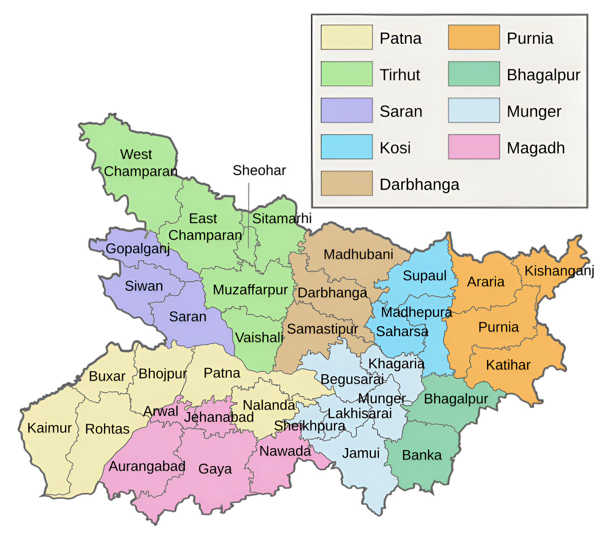
Darbhanga Division and its Districts
Darbhanga Division is an administrative division located in the northern part of Bihar, India. Known for its rich cultural heritage, historical significance, and vibrant traditions, it plays an important role in the cultural and economic landscape of Bihar. It is a part of historical Mithila region. The Division is bounded on the north by Nepal , on the south by the division Munghyr, on the east by Saharsa Division and on the west by the Muzaffarpur Division.
Darbhanga Division came into existence on 26 October 1973 after split of Tirhut Division. Prior to being established as a distinct district in 1875, Darbhanga was a part of Sarkar Tirhut. Prior to the creation of the Tirhut division, which had its headquarters at Muzaffarpur, in 1908, it was a part of the Patna division. Darbhanga, Madhubani, and Samastipur are the three districts that make up the Darbhanga division. The subdivisions were first established in 1845 as Darbhanga Sadar, 1866 as Madhubani, and 1867 as Samastipur (then called Tajpur). Madhubani and Samastipur subdivisions were promoted to autonomous districts as a part of the state’s district reform, which went into force in 1972.
The Division is named for its sole town, Darbhanga, which serves as the Division headquarters. It is said that Darbhangi Khan, about whom very little is known, created the Division. They further say that the word Darbhanga is derived from Dwar Banga or Dari-Banga, which means ‘gateway to Bengal’. Given that Bengal and Bihar have historically been divided further to the east, this derivation does not seem to be particularly accurate. Nonetheless, it may be argued that this is where the linguistic and cultural ties to Bengal begin.
District
In 1961, Darbhanga town became a city with a population of one lakh or more. The Maharaja of Darbhanga resides in Darbhanga. The town of Darbhanga includes Laheriasarai, the headquarters of divisional and district government. The complex of palaces, temples, buildings, parks, gardens, and ponds in the Raj region is well-developed and exquisitely designed. The subsequent Maharajas constructed a variety of palaces, including the significant Nargauna Palace, Rambagh Palace, Anandbagh Bhawan, and Bela Palace. Lalit Narayan Mithila University and Kameshwar Singh Darbhanga Sanskrit University both use a number of buildings in Darbhanga. L. N. Mithilia University now occupies the former Raj Library.
In India, Darbhanga could be the only city with two universities on one campus. Through their generosity, the Maharajas of Darbhanga have always supported the academics of Maithili and Sanskrit and have long been generous patrons of literature and the arts. The Raj was established by Mahesh Thakur, a distinguished Sanskrit scholar. Emperor Akbar bestowed the estate upon him after being greatly influenced by Raghunandan Jha, a scholar and Mahesh Thakur student.
The division is well-known for trading cash crops, vegetables, fish, mangos, and makhana. Its educational establishments include Darbhanga Medical College, Women Institute of Technology, Darbhanga Engineering College, Chandradhari Mithila College, and Chandradhari Mithila Science College. Pusa Agriculture University, Samastipur College, R.K. College Madhubani, and several other establishments.
Municipality
There are five Nagar Panchayats in the Darbhanga Division: Jhanjharpur, Jainagar, Ghoghardiha, Rosera, and Dalsinghsarai; three Municipal Councils: Madhubani, Samastipur, and Benipur Municipal Councils; and one Municipal Corporation, Darbhanga Municipal Corporation, Darbhanga.
A town with a municipal corporation is Darbhanga. The fifth-largest city in Bihar is Darbhanga. It is one of North Bihar’s most significant divisions and largest cities. Another name for Darbhanga is the Heart of the Mithilanchal.
There are 12,686,330 people living in the Division as per the 2011 census. There are 6067065 women and 6619265 men in the population. The whole geographical area of the Darbhanga division is 8684 square kilometers. Longitudes 85 degrees 9 minutes East and 26 degrees 17 minutes North are its coordinates.
Key Facts About Darbhanga Division
- Country:
 India
India - State:
 Bihar
Bihar - Region: Mithila
- Established: 1973
- Area: 8684 km2 (3353 sq mi)
- Population (2011): 12,686,330
- Division Headquarters: Darbhanga
- Divisional Commissioner: H. R. Shrinivas
- Gram Panchyat: 1069 (approx)
- Villages: 3689 (approx)
- Number of Districts: 3 (Darbhanga, Madhubani, Samastipur)
- Coordinates: 26.17°N 85.9°E
- Subdivisions: 12
- Darbhanga Sadar, Benipur, Biraul, Madhubani Sadar, Benipatti, Jhanjarpur, Phulparas, Jainagar, Samastipur Sadar, Dalsinghsarai, Rosera, Patori
- No. of Blocks: 59
- Rivers: Kamala, Koshi, Bagmati, Ganga
- Geography:
- Fertile plains enriched by rivers like Kamala, Bagmati, and Ganga.
- Prone to flooding during monsoons, yet agriculturally prosperous.
- Transports:
- NH-27, NH-103, NH-122, NH-227, NH-227J, NH-227L, NH-322, NH-527A, NH-527B
- Railway Stations: Darbhanga, Laheriasarai, Laukaha Bazar
- Lok Sabha constituencies: 6
- Darbhanga, Jhanjharpur, Madhubani, Samastipur, Ujiarpur, Rosera
- Vidhan Sabha constituencies: 31
- Harlakhi, Benipatti, Khajauli, Babubarhi, Bisfi, Madhubani, Rajnagar, Jhanjharpur, Phulparas, Laukaha, Kusheshwar Asthan, Gaura Bauram, Benipur, Alinagar, Darbhanga Rural, Darbhanga, Hayaghat, Bahadurpur, Keoti, Jale, Kalyanpur, Warisnagar, Samastipur, Ujiarpur, Morwa, Sarairanjan, Mohiuddinnagar, Bibhutipur, Rosera, Hasanpur
- Official Website: darbhangadivision.bih.nic.in
Districts of Darbhanga Division (Administrative Structure)
The Darbhanga Division consists of three districts:
1. Darbhanga district:
- Area: 2,279 km2 (880 sq mi)
- Population (2011): 3,937,385
- Literacy Rate: 56.56%
- District Headquarters: Darbhanga
- Gram Panchayats: 324
- Villages: 1314 (approx)
- No. of Subdivision: 3 (Darbhanga Sadar, Benipur, Biraul)
- Police Station: 37
- Ashok Paper Mill Thana, Bahadurpur, Bahera, Baheri, Balbhadrapur Siwir, Biraul, Ghanshyampur, Hayaghat, Jale, Jamalpur, Kamtaul, Keoti, Kusheshwar Asthan, Laheriasarai, Manigachhi, Moro, Rayem, Sadar, Sakatpur, Simri, Singhwara, Sonki, Town Thana, University Thana, Vishanpur, Mahila Thana (OP- Nehra, Pataur, Bajitpur, Kotwali Chowk, Tilkeshwar, Fekla, Mabbi, Benta, Bhalpatti, Badgaon, Alinagar)
- No. of Blocks: 18
- Darbhanga Sadar, Bahadurpur, Baheri, Hayaghat, Hanuman Nagar, Jale, Singhwara, Keoti, Manigachhi, Tardih, Benipur, Alinagar, Biraul, Gaura Bauram, Kiratpur, Ghanshyampur, Kusheshwar Asthan, Kusheshwar Asthan East
- Municipal Corporation(Nagar Nigam): 1 (Darbhanga)
- Municipal Council(Nagar Parishad): 1 (Benipur)
- Lok Sabha constituency: 1 (Darbhanga)
- Vidhan Sabha constituencies: 11
- Kusheshwar Asthan, Gaura Bauram, Benipur, Alinagar, Darbhanga Rural, Darbhanga, Hayaghat, Bahadurpur, Keoti, Jale
- Key Features:
- Known as the “Cultural Capital of Bihar” and an epicenter of Mithila’s traditions.
- Home to landmarks like Darbhanga Raj Palace, Kameshwar Singh Darbhanga Sanskrit University, and Ahilya Sthan.
- Major trade hub for agricultural products like mangoes, makhana (fox nuts), and fish.
- Significance: A cultural, educational, and economic hub of Mithila.
- Official Website: darbhanga.nic.in
2. Madhubani district:
- Area: 3,501 km2 (1,352 sq mi)
- Population (2011): 4,487,379
- Literacy Rate: 60.9%
- District Headquarters: Madhubani
- Gram Panchayats: 399
- Villages: 1115 (approx)
- No. of Subdivision: 5 (Madhubani Sadar, Benipatti, Jhanjarpur, Phulparas, Jainagar)
- Police Station: 26
- Incharge of Thana, Nagar,OP Incharge- Patauna, Ounsi (SHO- Rahika, Pandaul, Sakri, Khajauli, Kaluahi, Rajnagar, Babubarhi, Jainagar, Ladania, Basopatti, Benipatti, Arer, Bisfi, Khirhar, Madhwapur, Saharghat, Harlakhi, Jhanjarpur, Bhiravsthan, Madhepur, Bheja, Lakhnaur, Andhrathadi)
- No. of Blocks: 21
- Rahika, Pandaul, Rajnagar, Babubarhi, Kaluahi, Khjauli, Jainagar, Ladania, Basopatti, Benipatti, Bisfi, Harlakhi, Madhwapur, Jhanjarpur, Andhrathadi, Lakhnaur, Madhepur, Phulparas, Ghoghardiha, Khutauna, Laukahi
- Municipal Corporation(Nagar Nigam): 1 (Madhubani)
- Municipal Council(Nagar Parishad): 1 (Jhanjarpur)
- Nagar Panchayat: 4 (Ghoghardiha, Jainagar, Benipatti, Phulparas)
- Lok Sabha constituency: 2 (Madhubani, Jhanjharpur)
- Vidhan Sabha constituencies: 10
- Harlakhi, Benipatti, Khajauli, Babubarhi, Bisfi, Madhubani, Rajnagar, Jhanjharpur, Phulparas, Laukaha
- Key Features:
- Globally recognized for Madhubani (Mithila) paintings, a traditional art form.
- Known for cultural festivities and historical landmarks like Kapileshwar Sthan and Uchaith Bhagwati Temple.
- A predominantly agrarian district producing paddy, wheat, and vegetables.
- Significance: A global ambassador for Mithila art and culture.
- Official Website: madhubani.nic.in
3. Samastipur district:
- Area: 2,904 km2 (1,121 sq mi)
- Population (2011): 4,261,566
- Literacy Rate: 61.86%
- District Headquarters: Samastipur
- Gram Panchayats: 346
- Villages: 1260 (approx)
- No. of Subdivision: 4 (Samastipur Sadar, Dalsinghsarai, Rosera, Patori)
- Police Station: 21
- No. of Blocks: 20
- Tajpur, Kalyanpur, Pusa, Morwa, Warisnagar, Samastipur, Sarairanjan, Khanpur, Rosera, Singhiya, Bibhutipur, Shivajinagar, Hasanpur, Bithan, Dalsinghsarai, Ujiyarpur, Vidyapatinagar, Patori, Mohanpur, Mohiuddinagar
- Municipal Corporation(Nagar Nigam): 1 (Samastipur)
- Municipal Council(Nagar Parishad): 4 (Rosera, Dalsinghsarai, Tajpur, Shahpur Patori)
- Nagar Panchayat: 3 (Musrigharari, Sarairanjan, Singhiya)
- Rivers: Bagmati, Ganga
- Lok Sabha constituency: 2 (Samastipur, Ujiarpur)
- Vidhan Sabha constituencies: 10
- Kalyanpur, Warisnagar, Samastipur, Ujiarpur, Morwa, Sarairanjan, Mohiuddinnagar, Bibhutipur, Rosera, Hasanpur
- Key Features:
- An agricultural district known for its production of sugarcane, rice, and maize.
- Famous for Khudiram Bose Memorial and Mangalgarh Fort.
- Houses several sugar mills and agro-based industries.
- Significance: A vital agricultural and industrial district in the region.
- Official Website: samastipur.nic.in
Each district has its unique identity while contributing collectively to the division’s culture and economy.
Geographical Overview
- Location: Situated in the Mithila region of Bihar, Darbhanga Division lies north of the Ganges River. It shares borders with Nepal to the north, making it strategically significant.
- Rivers: Key rivers include the Bagmati, Kamla, and Gandak, which are prone to seasonal flooding, influencing agriculture and local livelihoods.
- Climate: The region experiences a humid subtropical climate, characterized by hot summers, monsoon rains, and cool winters.
Cultural Significance
- Mithila Region: Darbhanga Division is part of the historic Mithila region, renowned for its Maithili culture, language, and traditions. The region is a center for classical music, Maithili literature, and art.
- Mithila Paintings: World-famous Madhubani (Mithila) paintings, characterized by intricate patterns and vibrant colors, originate from this area.
- Festivals: Major festivals include Chhath Puja, Durga Puja, and Saraswati Puja, celebrated with great enthusiasm.
Historical Background
- Ancient History: Darbhanga and its surroundings have been significant since ancient times, with Mithila historically being a hub of learning, philosophy, and governance. Scholars such as Vachaspati Mishra hailed from this region.
- Darbhanga Raj: During the British era, Darbhanga was the seat of the powerful Darbhanga Raj, a zamindari estate known for its wealth and patronage of art and culture.
- Contributions to Education: The division is home to the Kameshwar Singh Darbhanga Sanskrit University, which preserves and promotes classical Sanskrit literature.
Economy
- Agriculture: The economy is predominantly agrarian, with rice, wheat, maize, and lentils as major crops. The fertile Gangetic plains support intensive farming.
- Livelihood: Traditional occupations include weaving, pottery, and fisheries. The division is also a center for the production of makhana (fox nuts) and mangoes.
- Remittances: A significant portion of the population migrates to other parts of India for work, and remittances contribute substantially to the local economy.
Education
- Key Institutions:
- Lalit Narayan Mithila University (LNMU): Located in Darbhanga, it serves as a leading higher education institution in the region.
- Darbhanga Medical College and Hospital (DMCH): A prominent medical institution catering to the healthcare needs of northern Bihar.
- Traditional Learning Centers: The region has been a hub for Sanskrit education and Vedic learning.
Transportation and Connectivity
- Railways: Darbhanga is a major railway hub, connecting the division to other parts of Bihar and India.
- Roadways: The region is well-connected by national and state highways, though road infrastructure requires significant improvement in rural areas.
- Airport: Darbhanga Airport, operational since 2020, has enhanced connectivity and boosted tourism and trade.
Tourism
- Darbhanga Fort: A historical landmark that reflects the architectural grandeur of the region.
- Temples: The division is home to many ancient and revered temples, including the Shyama Mai Temple and Ahilya Sthan in Madhubani.
- Cultural Festivals: Tourism peaks during major festivals, attracting visitors to witness Mithila’s traditional lifestyle.
Challenges
- Flooding: The region is prone to recurrent floods, causing widespread damage to agriculture, infrastructure, and livelihoods.
- Infrastructure Development: Despite recent advancements, basic infrastructure like roads, healthcare, and education in rural areas needs improvement.
- Outmigration: A significant portion of the population migrates for employment, highlighting limited local job opportunities.
Key Highlights
- Identity: A vibrant representation of Mithila’s culture and heritage.
- Economic Potential: Rich in agriculture, arts, and human resources, with growing potential in trade and tourism.
- Resilience: Despite challenges, the region maintains its cultural and historical importance in Bihar.
Conclusion
The Darbhanga Division is a perfect blend of history, culture, and economic activity. Known for its Mithila traditions, educational institutions, and agricultural contributions, the division remains a vital part of Bihar’s heritage and development. Its cultural richness and economic potential make it a cornerstone of Bihar’s identity.
Would you like more details about any specific Topics on Bihar? Comment Below or Checkout these topics 😊
दरभंगा प्रमंडल और उसके जिले
दरभंगा प्रमंडल भारत के बिहार के उत्तरी भाग में स्थित एक प्रशासनिक प्रमंडल है। यह ऐतिहासिक मिथिला क्षेत्र का एक हिस्सा है। यह प्रमंडल उत्तर में नेपाल, दक्षिण में मुंगेर प्रमंडल, पूर्व में सहरसा प्रमंडल और पश्चिम में मुजफ्फरपुर प्रमंडल से घिरा हुआ है।
तिरहुत डिवीजन के विभाजन के बाद 26 अक्टूबर 1973 को दरभंगा डिवीजन की स्थापना की गई। 1875 में एक अलग जिले के रूप में स्थापित होने से पहले, दरभंगा सरकार तिरहुत का एक हिस्सा था। 1908 में तिरहुत प्रमंडल के निर्माण से पहले, जिसका मुख्यालय मुजफ्फरपुर में था, यह पटना प्रमंडल का एक हिस्सा था। दरभंगा, मधुबनी और समस्तीपुर तीन जिले हैं जो दरभंगा प्रमंडल बनाते हैं। उपखंडों की स्थापना सबसे पहले 1845 में दरभंगा सदर, 1866 में मधुबनी और 1867 में समस्तीपुर (तब ताजपुर कहा जाता था) के रूप में की गई थी। मधुबनी और समस्तीपुर उपखंडों को राज्य के जिला सुधार के एक भाग के रूप में स्वायत्त जिलों में पदोन्नत किया गया था, जो 1972 में लागू हुआ।
इस डिवीजन का नाम इसके एकमात्र शहर दरभंगा के नाम पर रखा गया है, जो डिवीजन मुख्यालय के रूप में कार्य करता है। ऐसा कहा जाता है कि दरभंगी खान, जिनके बारे में बहुत कम जानकारी है, ने डिवीजन का निर्माण किया था। वे आगे कहते हैं कि दरभंगा शब्द द्वार बंगा या दारी-बंगा से लिया गया है, जिसका अर्थ है ‘बंगाल का प्रवेश द्वार’। यह देखते हुए कि बंगाल और बिहार ऐतिहासिक रूप से पूर्व की ओर विभाजित हैं, यह व्युत्पत्ति विशेष रूप से सटीक नहीं लगती है। फिर भी, यह तर्क दिया जा सकता है कि यहीं से बंगाल के साथ भाषाई और सांस्कृतिक संबंध शुरू होते हैं।
दरभंगा क्षेत्र
1961 में दरभंगा शहर एक लाख या उससे अधिक की आबादी वाला शहर बन गया। दरभंगा के महाराजा दरभंगा में रहते हैं। दरभंगा शहर में लहेरियासराय शामिल है, जो प्रमंडलीय और जिला सरकार का मुख्यालय है। राज क्षेत्र में महलों, मंदिरों, इमारतों, पार्कों, उद्यानों और तालाबों का परिसर अच्छी तरह से विकसित और उत्कृष्ट रूप से डिज़ाइन किया गया है। बाद के महाराजाओं ने कई तरह के महलों का निर्माण किया, जिनमें महत्वपूर्ण नरगौना पैलेस, रामबाग पैलेस, आनंदबाग भवन और बेला पैलेस शामिल हैं। ललित नारायण मिथिला विश्वविद्यालय और कामेश्वर सिंह दरभंगा संस्कृत विश्वविद्यालय दोनों दरभंगा में कई इमारतों का उपयोग करते हैं। एल. एन. मिथिलिया विश्वविद्यालय अब पूर्व राज पुस्तकालय पर कब्जा कर लेता है।
भारत में, दरभंगा एक ऐसा शहर हो सकता है जिसके एक परिसर में दो विश्वविद्यालय हों। अपनी उदारता के माध्यम से, दरभंगा के महाराजाओं ने हमेशा मैथिली और संस्कृत के शिक्षाविदों का समर्थन किया है और लंबे समय से साहित्य और कला के उदार संरक्षक रहे हैं। राज की स्थापना महेश ठाकुर नामक एक प्रतिष्ठित संस्कृत विद्वान ने की थी। महेश ठाकुर के छात्र और विद्वान रघुनंदन झा से बहुत प्रभावित होकर बादशाह अकबर ने उन्हें यह संपत्ति प्रदान की थी।
यह प्रभाग नकदी फसलों, सब्जियों, मछली, आम और मखाना के व्यापार के लिए प्रसिद्ध है। इसके शैक्षणिक संस्थानों में दरभंगा मेडिकल कॉलेज, महिला प्रौद्योगिकी संस्थान, दरभंगा इंजीनियरिंग कॉलेज, चंद्रधारी मिथिला कॉलेज और चंद्रधारी मिथिला विज्ञान कॉलेज शामिल हैं। पूसा कृषि विश्वविद्यालय, समस्तीपुर कॉलेज, आर.के. कॉलेज मधुबनी और कई अन्य संस्थान हैं।
नगर पालिका
दरभंगा प्रमंडल में पांच नगर पंचायतें हैं: झंझारपुर, जयनगर, घोघरडीहा, रोसेरा और दलसिंहसराय; तीन नगर परिषद: मधुबनी, समस्तीपुर, और बेनीपुर नगर परिषद; और एक नगर निगम, दरभंगा नगर निगम, दरभंगा।
नगर निगम वाला शहर दरभंगा है। बिहार का पांचवा सबसे बड़ा शहर दरभंगा है। यह उत्तर बिहार के सबसे महत्वपूर्ण प्रभागों और सबसे बड़े शहरों में से एक है। दरभंगा का दूसरा नाम मिथिलांचल का हृदय है।
2011 की जनगणना के अनुसार संभाग में 12,686,330 लोग रहते हैं। जनसंख्या में 6067065 महिलाएं और 6619265 पुरुष हैं। दरभंगा प्रमंडल का संपूर्ण भौगोलिक क्षेत्रफल 8684 वर्ग किलोमीटर है। देशांतर 85 डिग्री 9 मिनट पूर्व और 26 डिग्री 17 मिनट उत्तर इसके निर्देशांक हैं। अपनी समृद्ध सांस्कृतिक विरासत, ऐतिहासिक महत्व और जीवंत परंपराओं के लिए जाना जाने वाला यह प्रमंडल बिहार के सांस्कृतिक और आर्थिक परिदृश्य में महत्वपूर्ण भूमिका निभाता है।
दरभंगा प्रमंडल के बारे में मुख्य तथ्य
- देश: भारत
- राज्य: बिहार
- क्षेत्र: मिथिला
- स्थापना: 1973
- प्रमंडल मुख्यालय: दरभंगा
- संभागीय आयुक्त: एच. आर. श्रीनिवास
- क्षेत्रफल: 8684 km2 (3353 वर्ग मील)
- जनसंख्या (2011): 12,686,330
- ब्लॉकों की संख्या: 59
- ग्राम पंचायत: 1069 (लगभग)
- गांव: 3689 (लगभग)
- जिलों की संख्या: 3 (दरभंगा, मधुबनी, समस्तीपुर)
- निर्देशांक: 26.17°N 85.9°E
- उपखंड: 12
- दरभंगा सदर, बेनीपुर, बिरौल, मधुबनी सदर, बेनीपट्टी, झंझारपुर, फुलपरास, जयनगर, समस्तीपुर सदर, दलसिंहसराय, रोसेरा, पटोरी
- नदियाँ: कमला, कोशी, बागमती, गंगा
- भूगोल:
- कमला, बागमती और गंगा जैसी नदियों से समृद्ध उपजाऊ मैदान।
- मानसून के दौरान बाढ़ की आशंका, फिर भी कृषि की दृष्टि से समृद्ध।
- परिवहन:
- NH-27, NH-103, NH-122, NH-227, NH-227J, NH-227L, NH-322, NH-527A, NH-527B
- रेलवे स्टेशन: दरभंगा, लहेरियासराय, लौकहा बाजार
- लोकसभा क्षेत्र: 6
- दरभंगा, झंझारपुर, मधुबनी, समस्तीपुर, उजियारपुर, रोसेरा
- विधान सभा क्षेत्र: 31
- हरलाखी, बेनीपट्टी, खजौली, बाबूबरही, बिस्फी, मधुबनी, राजनगर, झंझारपुर, फुलपरास, लौकहा, कुशेश्वरस्थान, गौरा बौराम, बेनीपुर, अलीनगर, दरभंगा ग्रामीण, दरभंगा, हायाघाट, बहादुरपुर, केवटी, जाले, कल्याणपुर, वारिसनगर, समस्तीपुर, उजियारपुर , मोरवा, सरायरंजन, मोहिउद्दीननगर, विभूतिपुर, रोसरा, हसनपुर
- आधिकारिक वेबसाइट: darbhangadivision.bih.nic.in
दरभंगा प्रमंडल के जिले (प्रशासनिक संरचना)
दरभंगा प्रमंडल में तीन जिले शामिल हैं:
1. दरभंगा ज़िला
- क्षेत्रफल: 2,279 km2 (880 वर्ग मील)
- जनसंख्या (2011): 3,937,385
- साक्षरता दर: 56.56%
- जिला मुख्यालय: दरभंगा
- ग्राम पंचायतें: 324
- गाँव: 1314 (लगभग)
- अनुमण्डल की संख्या: 3 (दरभंगा सदर, बेनीपुर, बिरौल)
- पुलिस स्टेशन: 37
- अशोक पेपर मिल थाना, बहादुरपुर, बहेरा, बहेरी, बलभद्रपुर सिवीर, बिरौल, घनश्यामपुर, हायाघाट, जाले, जमालपुर, कमतौल, केवटी, कुशेश्वर स्थान, लहेरियासराय, मनीगाछी, मोरो, रायम, सदर, सकतपुर, सिमरी, सिंघवारा, सोनकी, टाउन थाना, विश्वविद्यालय थाना, विशनपुर, महिला थाना (ओपी- नेहरा, पतौर, बाजितपुर, कोतवाली चौक, तिलकेश्वर, फेकला, मब्बी, बेंता, भालपट्टी, बड़गांव, अलीनगर)
- ब्लॉकों की संख्या: 18
- दरभंगा सदर, बहादुरपुर, बहेरी, हायाघाट, हनुमान नगर, जाले, सिंहवाड़ा, केवटी, मनीगाछी, तारडीह, बेनीपुर, अलीनगर, बिरौल, गौरा बौराम, किरतपुर, घनश्यामपुर, कुशेश्वर अस्थान, कुशेश्वर अस्थान पूर्वी
- नगर निगम: 1 (दरभंगा)
- नगर परिषद: 1 (बेनीपुर)
- लोकसभा क्षेत्र: 1 (दरभंगा)
- विधान सभा क्षेत्र: 11
- कुशेश्वर स्थान, गौरा बौराम, बेनीपुर, अलीनगर, दरभंगा ग्रामीण, दरभंगा, हायाघाट, बहादुरपुर, केवटी, जाले
- प्रमुख विशेषताऐं:
- “बिहार की सांस्कृतिक राजधानी” और मिथिला का केंद्र के रूप में जाना जाता है परंपराएँ।
- दरभंगा राज पैलेस, कामेश्वर सिंह दरभंगा संस्कृत विश्वविद्यालय और अहिल्या स्थान जैसे ऐतिहासिक स्थलों का घर।
- आम, मखाना और मछली जैसे कृषि उत्पादों के लिए प्रमुख व्यापार केंद्र।
- महत्व: मिथिला का एक सांस्कृतिक, शैक्षिक और आर्थिक केंद्र ।
- आधिकारिक वेबसाइट: darbhanga.nic.in
2. मधुबनी ज़िला
- क्षेत्रफल: 3,501 km2 (1,352 वर्ग मील)
- जनसंख्या (2011): 4,487,379
- साक्षरता दर: 60.9%
- जिला मुख्यालय: मधुबनी
- ग्राम पंचायतें: 399
- गाँव: 1115 (लगभग)
- अनुमण्डल की संख्या: 5 (मधुबनी सदर, बेनीपट्टी, झंझारपुर, फुलपरास, जयनगर)
- पुलिस स्टेशन: 26
- थाना प्रभारी, नगर, ओपी प्रभारी- पतौना, औंसी (थाना प्रभारी- रहिका, पंडौल, सकरी, खजौली, कलुआही, राजनगर, बाबूबरही, जयनगर, लदनियां, बासोपट्टी, बेनीपट्टी, अरेर, बिस्फी, खिरहर, मधवापुर, साहरघाट, हरलाखी, झंझारपुर , भिरावस्थान, मधेपुर, भेजा, लखनौर, अंधराठाढ़ी)
- ब्लॉकों की संख्या: 21
- रहिका, पंडौल, राजनगर, बाबूबरही, कलुआही, खजौली, जयनगर, लदनियां, बासोपट्टी, बेनीपट्टी, बिस्फी, हरलाखी, मधवापुर, झंझारपुर, अंधराठाढ़ी, लखनौर, मधेपुर, फुलपरास, घोघरडीहा, खुटौना, लौकही
- नगर निगम: 1 (मधुबनी)
- नगर परिषद: 1 (झंझारपुर)
- लोकसभा क्षेत्र: 2 (मधुबनी, झंझारपुर)
- नगर पंचायत: 4 (घोघरडीहा, जयनगर, बेनीपट्टी, फुलपरास)
- विधान सभा क्षेत्र: 10
- हरलाखी, बेनीपट्टी, खजौली, बाबूबरही, बिस्फी, मधुबनी, राजनगर, झंझारपुर, फुलपरास, लौकहा
- प्रमुख विशेषताऐं:
- विश्व स्तर पर पहचान बनी है मधुबनी की (मिथिला) पेंटिंग, एक पारंपरिक कला रूप।
- सांस्कृतिक उत्सवों और कपिलेश्वर स्थान और उच्चैठ भगवती मंदिर जैसे ऐतिहासिक स्थलों के लिए जाना जाता है।
- धान, गेहूं और सब्जियों का उत्पादन करने वाला एक मुख्य रूप से कृषि प्रधान जिला।
- महत्व: मिथिला कला और संस्कृति का एक वैश्विक राजदूत।
- आधिकारिक वेबसाइट: madhubani.nic.in
3. समस्तीपुर ज़िला
- क्षेत्रफल: 2,904 km2 (1,121 वर्ग मील)
- जनसंख्या (2011): 4,261,566
- साक्षरता दर: 61.86%
- जिला मुख्यालय: समस्तीपुर
- ग्राम पंचायतें: 346
- गाँव: 1260 (लगभग)
- अनुमण्डल की संख्या: 4 (समस्तीपुर सदर, दलसिंहसराय, रोसरा, पटोरी)
- पुलिस स्टेशन: 21
- ब्लॉकों की संख्या: 20
- ताजपुर, कल्याणपुर, पूसा, मोरवा, वारिसनगर, समस्तीपुर, सरायरंजन, खानपुर, रोसरा, सिंघिया, विभूतिपुर, शिवाजीनगर, हसनपुर, बिथान, दलसिंहसराय, उजियारपुर, विद्यापतिनगर, पटोरी, मोहनपुर, मोहिउद्दीनगर
- नगर निगम: 1 (समस्तीपुर)
- नगर परिषद: 4 (रोसेरा, दलसिंहसराय, ताजपुर, शाहपुर पटोरी)
- नदियाँ: बागमती, गंगा
- नगर पंचायत: 3 (मुसरीघरारी, सरायरंजन, सिंघिया)
- लोकसभा क्षेत्र: 2 (समस्तीपुर, उजियारपुर)
- विधानसभा क्षेत्र: 10
- कल्याणपुर, वारिसनगर, समस्तीपुर, उजियारपुर, मोरवा , सरायरंजन, मोहिउद्दीननगर, बिभूतिपुर, रोसड़ा, हसनपुर
- मुख्य विशेषताएं:
- एक कृषि जिला जो गन्ना, चावल और मक्का के उत्पादन के लिए जाना जाता है।
- खुदीराम बोस स्मारक और मंगलगढ़ किले के लिए प्रसिद्ध है।
- कई चीनी मिलें और कृषि आधारित उद्योग हैं।
- महत्व: ए क्षेत्र का महत्वपूर्ण कृषि और औद्योगिक जिला।
- आधिकारिक वेबसाइट: samastipur.nic.in
प्रत्येक जिले की अपनी विशिष्ट पहचान है, जबकि वे सामूहिक रूप से संभाग की संस्कृति और अर्थव्यवस्था में योगदान करते हैं।
भौगोलिक अवलोकन
- स्थान: बिहार के मिथिला क्षेत्र में स्थित, दरभंगा डिवीजन गंगा नदी के उत्तर में स्थित है। यह उत्तर में नेपाल के साथ सीमा साझा करता है, जो इसे रणनीतिक रूप से महत्वपूर्ण बनाता है।
- नदियाँ: प्रमुख नदियों में बागमती, कमला और गंडक शामिल हैं, जो मौसमी बाढ़ के लिए प्रवण हैं, जो कृषि और स्थानीय आजीविका को प्रभावित करती हैं।
- जलवायु: इस क्षेत्र में आर्द्र उपोष्णकटिबंधीय जलवायु का अनुभव होता है, जिसमें गर्म ग्रीष्मकाल, मानसून की बारिश और ठंडी सर्दियाँ होती हैं।
सांस्कृतिक महत्व
- मिथिला क्षेत्र: दरभंगा डिवीजन ऐतिहासिक मिथिला क्षेत्र का हिस्सा है, जो अपनी मैथिली संस्कृति, भाषा और परंपराओं के लिए प्रसिद्ध है। यह क्षेत्र शास्त्रीय संगीत, मैथिली साहित्य और कला का केंद्र है।
- मिथिला पेंटिंग: जटिल पैटर्न और जीवंत रंगों की विशेषता वाली विश्व प्रसिद्ध मधुबनी (मिथिला) पेंटिंग इसी क्षेत्र से आती हैं।
- त्यौहार: प्रमुख त्योहारों में छठ पूजा, दुर्गा पूजा और सरस्वती पूजा शामिल हैं, जिन्हें बड़े उत्साह के साथ मनाया जाता है।
ऐतिहासिक पृष्ठभूमि
- प्राचीन इतिहास: दरभंगा और इसके आस-पास के क्षेत्र प्राचीन काल से ही महत्वपूर्ण रहे हैं, मिथिला ऐतिहासिक रूप से शिक्षा, दर्शन और शासन का केंद्र रहा है। वाचस्पति मिश्रा जैसे विद्वान इसी क्षेत्र से आए थे।
- दरभंगा राज: ब्रिटिश काल के दौरान, दरभंगा शक्तिशाली दरभंगा राज की राजधानी थी, जो एक ज़मींदारी एस्टेट था जो अपनी संपत्ति और कला और संस्कृति के संरक्षण के लिए जाना जाता था।
- शिक्षा में योगदान: यह प्रभाग कामेश्वर सिंह दरभंगा संस्कृत विश्वविद्यालय का घर है, जो शास्त्रीय संस्कृत साहित्य को संरक्षित और बढ़ावा देता है।
अर्थव्यवस्था
- कृषि: यहाँ की अर्थव्यवस्था मुख्य रूप से कृषि प्रधान है, जिसमें चावल, गेहूँ, मक्का और दालें प्रमुख फसलें हैं। उपजाऊ गंगा के मैदान गहन खेती का समर्थन करते हैं।
- आजीविका: पारंपरिक व्यवसायों में बुनाई, मिट्टी के बर्तन बनाना और मछली पालन शामिल हैं। यह प्रभाग मखाना (फॉक्स नट्स) और आम के उत्पादन का भी केंद्र है।
- प्रेषण: आबादी का एक महत्वपूर्ण हिस्सा काम के लिए भारत के अन्य हिस्सों में जाता है, और प्रेषण स्थानीय अर्थव्यवस्था में काफी योगदान देता है।
शिक्षा
- प्रमुख संस्थान:
- ललित नारायण मिथिला विश्वविद्यालय (एलएनएमयू): दरभंगा में स्थित, यह क्षेत्र में एक अग्रणी उच्च शिक्षा संस्थान के रूप में कार्य करता है।
- दरभंगा मेडिकल कॉलेज और अस्पताल (डीएमसीएच): उत्तरी बिहार की स्वास्थ्य सेवा आवश्यकताओं को पूरा करने वाला एक प्रमुख चिकित्सा संस्थान।
- पारंपरिक शिक्षण केंद्र: यह क्षेत्र संस्कृत शिक्षा और वैदिक शिक्षा का केंद्र रहा है।
परिवहन और संपर्क
- रेलवे: दरभंगा एक प्रमुख रेलवे हब है, जो इस संभाग को बिहार और भारत के अन्य हिस्सों से जोड़ता है।
- सड़क मार्ग: यह क्षेत्र राष्ट्रीय और राज्य राजमार्गों से अच्छी तरह जुड़ा हुआ है, हालांकि ग्रामीण क्षेत्रों में सड़क के बुनियादी ढांचे में महत्वपूर्ण सुधार की आवश्यकता है।
- हवाई अड्डा: 2020 से चालू दरभंगा हवाई अड्डे ने कनेक्टिविटी को बढ़ाया है और पर्यटन और व्यापार को बढ़ावा दिया है।
पर्यटन
- दरभंगा किला: एक ऐतिहासिक स्थल जो इस क्षेत्र की वास्तुकला की भव्यता को दर्शाता है।
- मंदिर: यह प्रभाग कई प्राचीन और पूजनीय मंदिरों का घर है, जिनमें मधुबनी में श्यामा माई मंदिर और अहिल्या स्थान शामिल हैं।
- सांस्कृतिक उत्सव: प्रमुख त्योहारों के दौरान पर्यटन चरम पर होता है, जो मिथिला की पारंपरिक जीवनशैली को देखने के लिए आगंतुकों को आकर्षित करता है।
चुनौतियाँ
- बाढ़: यह क्षेत्र बार-बार बाढ़ की चपेट में रहता है, जिससे कृषि, बुनियादी ढांचे और आजीविका को व्यापक नुकसान होता है।
- बुनियादी ढांचे का विकास: हाल की प्रगति के बावजूद, ग्रामीण क्षेत्रों में सड़क, स्वास्थ्य सेवा और शिक्षा जैसे बुनियादी ढांचे में सुधार की आवश्यकता है।
- बाहर पलायन: आबादी का एक बड़ा हिस्सा रोजगार के लिए पलायन करता है, जिससे स्थानीय स्तर पर रोजगार के सीमित अवसर सामने आते हैं।
मुख्य विशेषताएँ
- पहचान: मिथिला की संस्कृति और विरासत का जीवंत प्रतिनिधित्व।
- आर्थिक क्षमता: कृषि, कला और मानव संसाधनों में समृद्ध, व्यापार और पर्यटन में बढ़ती क्षमता के साथ।
- लचीलापन: चुनौतियों के बावजूद, यह क्षेत्र बिहार में अपना सांस्कृतिक और ऐतिहासिक महत्व बनाए रखता है।
निष्कर्ष
दरभंगा प्रमंडल इतिहास, संस्कृति और आर्थिक गतिविधि का एक आदर्श मिश्रण है। अपनी मिथिला परंपराओं, शैक्षणिक संस्थानों और कृषि योगदान के लिए जाना जाने वाला यह प्रमंडल बिहार की विरासत और विकास का एक महत्वपूर्ण हिस्सा बना हुआ है। इसकी सांस्कृतिक समृद्धि और आर्थिक क्षमता इसे बिहार की पहचान का आधार बनाती है।
क्या आप बिहार के किसी विशेष विषय के बारे में अधिक जानकारी चाहते हैं? नीचे टिप्पणी करें 😊
पदानुक्रमिक संरचना: बिहार का विस्तृत रोडमैप
बिहार में प्रमंडल और उसके जिलों का विवरण
Important Link
𝕋𝕙𝕒𝕟𝕜 𝕐𝕠𝕦 𝔽𝕠𝕣 𝕍𝕚𝕤𝕚𝕥𝕚𝕟𝕘 𝕆𝕦𝕣 𝕎𝕖𝕓𝕤𝕚𝕥𝕖𝕤 🙂
6 thoughts on “Darbhanga Division and its Special Districts of Bihar”