
Kosi Division: An Overview
Kosi Division is one of the administrative divisions of Bihar, located in the northeastern part of the state. Known for its unique geography, cultural heritage, and economic challenges, it derives its name from the Kosi River, which dominates the region’s landscape.
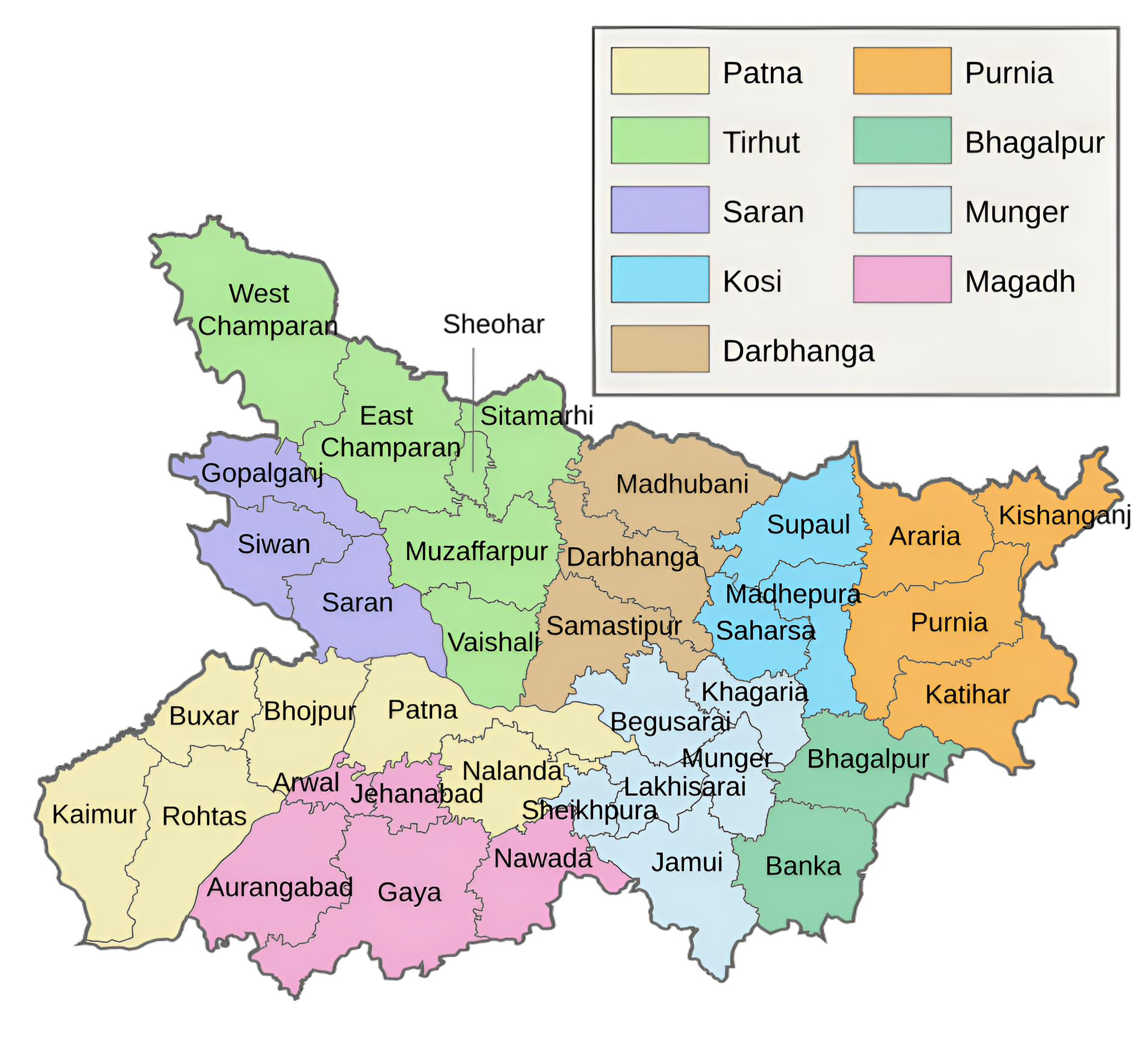
A Division of Kosi, the creation date of Saharsa is 2nd October 1972. Its Saharsa district serves as its administrative center. It is situated in the Mithila area at 25.880N and 86.60E. The Bagmati River in the south, the Sursar River in the east, the Kosi River in the west, and the Himalayas (Nepal) in the north form its borders. The districts of Saharsa, Purnea, and Katihar comprised the Kosi division upon its founding. Later, as a result of the creation of additional districts and an administrative structure, Purnea division was established, incorporating the districts of Kosi, Purnea, and Katihar in Saharsa. Currently, Kosi Division is divided into three districts: Madhepura, Supaul, and Saharsa.
There are 1,21,20,117 people living in Kosi division as per the 2011 census. Paan, Paag, Maachh (fish), and Makhana are the four objects that are regarded as the primary cultural characteristics of Kosi division. Makhana agriculture is another reason for this region’s fame. The Kosi division of Saharsa is home to several more religious, archeological, and picturesque locations, such as Ugratara Shaktipeeth, Mahishi, Sun Temple, Kandaha, Vaneshwar Mahadev Temple, Bangaon, Mateshwar Temple, Kantho, Sant Laxminath Gosai Kuti, and Sinheshwar Shiv temple.
History
The Mithila area includes the current Kosi division, which was formerly a part of Saharsa district. After being colonized by Indo-Aryan peoples who founded the Mithila Kingdom (also known as the Kingdom of the Videhas), Mithila first rose to prominence. Together with Kuru and Pañcāla, the Kingdom of the Videhas emerged as one of South Asia’s principal political and cultural hubs during the late Vedic era (c. 1100–500 BCE). The Janakas were the rulers of the Kingdom of the Videhas. Later, the Mithila Kingdom became part of the Vajjika League, which was headquartered in the Mithila city of Vaishali.
Key Facts About Kosi Division
- Country:
 India
India - State:
 Bihar
Bihar - Region: Mithila
- Established: 1972
- Division Headquarters: Saharsa
- Divisional Commissioner: Dinesh Kumar IAS
- Area: 5899 km2 (2277 sq mi)
- Population (2011): 12,120,117
- Number of Districts: 3 (Saharsa, Madhepur, Supaul)
- Gram Panchyat: 486 (approx)
- Villages: 1450 (approx)
- Coordinates: 25.88°N 86.6°E
- Subdivisions: 8
- Saharsa, Simri Bakhtiyarpur, Madhepura, Udakishunganj, Supaul Sadar, Triveniganj, Birpur, Nirmali
- No. of Blocks: 43
- Kahara, Sattar Kataiya, Nauhatta, Mahishi, Sonbarsa, Sour Bazar, Patarghat, Simri Bakhtiyarpur, Salkhua, Banma Itahri, Madhepura, Singheshwar, Murliganj, Gamharia, Ghailar, Kumarkhand, Shankarpur, Chausa, Puraini, Gwalpara, Bihariganj, Uda kishunganj, Alamnagar, Supaul, Kishanpur, Pipra, Bhaptiyahi, Tirveniganj, Jadia, Balua Bazar, Bhimpur, Chhatapur, Birpur, Karjain, Raghopur, Pratapganj, Nirmali, Marauna, Ratanpura, Kunauli
- Dams, Barrages, Bridges: Koshi Barrage, Kosi embankment, Sino-Nepal Friendship Bridge
- Geographical features:
- Tibetan Plateau, Himalayas, Mahabharat Range (Lower Himalayan Range), Sivalik Hills, Chatra Gorge
- Rivers:
- Arun/Bum-chu, Barun, Bhote koshi, Dudh Koshi, Hongu, Imja Khola, Indravati, Kosi, Sabha, Sangkhuwa, Siswa, Sunkoshi or Matsang Tsangpo, Tamur
- Geography:
- Located in a flood-prone region dominated by the Kosi River and its tributaries.
- Fertile alluvial plains support a predominantly agrarian economy.
- Transports:
- NH 27, NH 57, NH 106, NH 107, NH 327E, NH 327A, SH 91, SH 76
- Friendship Highway
- Araniko Highway
- Mahendra Highway
- Indo-Nepal border road
- Lok Sabha constituencies: 3 (Madhepura, Saharsa, Supaul)
- Vidhan Sabha constituencies: 13
- Sonbarsha, Saharsa, Simri Bakhtiarpur, Mahishi, Alamnagar, Bihariganj, Singheshwar, Madhepura, Nirmali, Pipra, Supaul, Triveniganj, Chhatapur
- Official Website: kosidivision.bih.nic.in
Districts of Kosi Division (Administrative Structure)
The Kosi Division comprises three districts:
1. Saharsa district:
- Area: 1,702 km2 (657 sq mi)
- Population (2011): 1,900,661
- Literacy Rate: 54.57%
- District Headquarters: Saharsa
- Gram Panchayats: 135
- Villages: 445 (approx)
- No. of Subdivision: 2 (Saharsa, Simri Bakhtiyarpur)
- Police Station: 35
- No. of Blocks: 10
- Kahara, Sattar Kataiya, Nauhatta, Mahishi, Sonbarsa, Sour Bazar, Patarghat, Simri Bakhtiyarpur, Salkhua, Banma Itahri
- Municipal Council(Nagar Parishad): 1 (Saharsa)
- Nagar Panchayat: 1 (Simri Bakhtiyarpur)
- Rivers: Koshi
- Lok Sabha constituency: 1 (Madhepura)
- Vidhan Sabha constituencies: 4 (Sonbarsha, Saharsa, Simri Bakhtiarpur, Mahishi)
- Key Features:
- A major agricultural district, producing paddy, wheat, and maize.
- Known for its connection to Mithila culture and Maithili language.
- Saharsa is a hub for education and administration in the region.
- Significance: Acts as the division’s administrative and economic center.
- Official Website: saharsa.nic.in
2. Madhepura district:
- Area: 1,787 km2 (690 sq mi)
- Population (2011): 2,001,762
- Literacy Rate: 53.78%
- District Headquarters: Madhepura
- Gram Panchayats: 170
- Villages: 449 (approx)
- No. of Subdivision: 2 (Madhepura, Udakishunganj)
- Police Station: 15
- MADHEPURA, SINGHESWAR, GAMHARIYA, SC/ST THANA, SHANKARPUR, MURLIGANJ, KUMARKHAND, SRINAGAR, MAHILA THANA, UDAKISHUNGANJ, CHAUSA, ALAMNAGAR, BIHARIGANJ, PURAINI, GWALPARA
- No. of Blocks: 13
- Madhepura, Singheshwar, Murliganj, Gamharia, Ghailar, Kumarkhand, Shankarpur, Chausa, Puraini, Gwalpara, Bihariganj, Uda kishunganj, Alamnagar
- Municipal Council(Nagar Parishad): 1 (Madhepura)
- Nagar Panchayat: 1 (Murliganj)
- Rivers: Koshi
- Lok Sabha constituency: 1 (Madhepura)
- Vidhan Sabha constituencies: 4 (Alamnagar, Bihariganj, Singheshwar, Madhepura)
- Key Features:
- Known for the Electric Locomotive Factory, a significant contributor to India’s railways.
- Primarily an agrarian district with fertile lands producing rice, sugarcane, and pulses.
- Historically connected to the freedom movement and Mithila culture.
- Significance: An emerging industrial district with agricultural roots.
- Official Website: madhepura.nic.in
3. Supaul district:
- Area: 2,410 km2 (930 sq mi)
- Population (2011): 2,229,076
- Literacy Rate: 72.86%
- District Headquarters: Supaul
- Gram Panchayats: 181
- Villages: 556 (approx)
- No. of Subdivision: 4 (Supaul Sadar, Triveniganj, Birpur, Nirmali)
- Police Station: 20
- Supaul, Kishanpur, Pipra, Bhaptiyahi, Tirveniganj, Jadia, Balua Bazar, Bhimpur, Chhatapur, Birpur, Karjain, Raghopur, Pratapganj, Nirmali, Marauna, Ratanpura, Kunauli
- No. of Blocks: 11
- Supaul, Kishanpur, Saraigarh Bhaptiyahi, Pipra, Triveniganj, Raghopur, chhatapur, Nirmali, Marauna, Basantpur, pratapganj
- Municipal Council(Nagar Parishad): 1 (Supaul)
- Nagar Panchayat: 2 (Birpur, Nirmali)
- Rivers: Koshi
- Lok Sabha constituency:1 (Supaul)
- Vidhan Sabha constituencies: 5 (Nirmali, Pipra, Supaul, Triveniganj, Chhatapur)
- Key Features:
- A border district near Nepal, strategically important for cross-border trade.
- Fertile lands enriched by the Kosi River, supporting rice and jute production.
- Known for the Kosi Barrage, a vital irrigation and flood control project.
- Significance: A district of strategic, agricultural, and developmental importance.
- Official Website: supaul.nic.in
These districts together form an integral part of the Mithila region and share cultural and linguistic similarities with neighboring divisions.
Geographical Overview
- Location: Kosi Division lies in the northeastern part of Bihar, bordered by Nepal to the north and other divisions like Darbhanga to the west and Purnia to the east.
- Rivers: The division is named after the Kosi River, often referred to as the “Sorrow of Bihar” due to its unpredictable floods. Other rivers include the Kamla, Bagmati, and Bhutahi Balan.
- Topography: The region consists of floodplains and is prone to waterlogging, making it a challenging area for infrastructure development.
- Climate: The division experiences a humid subtropical climate with hot summers, heavy monsoon rains, and mild winters.
Historical Significance
- Ancient History: The region has been part of the ancient Mithila Kingdom and holds significant cultural and historical importance in the Maithili-speaking region. It is mentioned in ancient scriptures and epics such as the Ramayana.
- British Era: During British rule, Kosi Division was part of the Bhagalpur and Darbhanga regions. It played a key role in the development of indigo plantations, though its floods often disrupted agriculture.
- Modern Era: Post-independence, Kosi Division was carved out as a separate administrative division in 1972 to focus on the region’s development.
Cultural Significance
- Maithili Culture: Kosi Division is an integral part of the Mithila region, known for the Maithili language, art, and traditions.
- Mithila Paintings: The traditional Madhubani paintings, though more prominent in neighboring regions, are also practiced here.
- Festivals: Chhath Puja, Durga Puja, and Makar Sankranti are widely celebrated, reflecting the region’s cultural richness.
- Folk Traditions: Maithili folk songs, especially those sung during weddings and festivals, are an important part of the cultural identity.
Economy
- Agriculture: The economy is predominantly agrarian, with rice, wheat, maize, and pulses as the major crops. The fertile alluvial soil is ideal for cultivation, though frequent floods impact productivity.
- Makhana Production: The region is famous for the cultivation and processing of makhana (fox nuts), a high-value crop grown in the waterlogged areas of the Kosi floodplain.
- Livelihood: Apart from agriculture, people engage in livestock rearing, fisheries, and small-scale trade. Many residents migrate to other parts of India for work, and remittances play a crucial role in the local economy.
- Challenges: Recurrent flooding, lack of industrial development, and poor infrastructure limit the region’s economic growth.
Education and Institutions
- Key Institutions:
- Bhupendra Narayan Mandal University (BNMU): Located in Madhepura, it is a key higher education institution in the division.
- Medical Colleges: Efforts are underway to improve healthcare education in the region.
- Traditional Learning: As part of the Mithila region, Kosi has a legacy of Sanskrit and Vedic education, though it is not as prominent today.
Transportation and Connectivity
- Railways: Kosi Division has a moderate railway network, with Saharsa being a major junction. However, the railway infrastructure is often affected by floods.
- Roadways: The region is connected by national and state highways, but road conditions in rural areas are poor.
- Bridges: The construction of bridges over the Kosi River, like the Kosi Mahasetu (mega bridge), has significantly improved connectivity in recent years.
- Proximity to Nepal: Its northern border with Nepal makes the division a potential hub for cross-border trade.
Tourism
Kosi Division offers several attractions that highlight its cultural and historical importance:
- Kosi River Basin: A unique geographic feature with scenic beauty, ideal for eco-tourism.
- Temples: The region is home to several temples and pilgrimage sites, which are popular among locals.
- Festivals: Cultural festivals like Chhath Puja attract tourists interested in experiencing Mithila’s traditions.
Challenges
- Flooding: The Kosi River is infamous for its unpredictable course changes and devastating floods, which disrupt agriculture, infrastructure, and daily life. Efforts to tame the river, such as embankments, have met with limited success.
- Infrastructure: The division suffers from inadequate infrastructure, including poor roads, lack of healthcare facilities, and limited access to quality education in rural areas.
- Outmigration: A significant portion of the population migrates to other states for employment due to limited local opportunities.
Key Highlights
- Agricultural Hub: The fertile plains and water resources make Kosi Division an important agricultural zone, despite the challenges posed by flooding.
- Cultural Identity: As part of Mithila, it shares in the rich Maithili heritage, including language, art, and traditions.
- Strategic Importance: Its proximity to Nepal and improvements in connectivity through projects like the Kosi Mahasetu enhance its economic potential.
- Economic Potential: The region’s makhana cultivation, fertile soil, and human resources have the potential to drive future growth, provided infrastructure and flood management issues are addressed.
Conclusion
Kosi Division is a region of contrasts, with immense potential for growth but significant challenges to overcome. Its rich cultural heritage, agricultural strength, and strategic location near Nepal provide opportunities for economic and social development. However, addressing the recurring floods, improving infrastructure, and creating local employment opportunities are critical to unlocking its full potential. With proper planning and investment, Kosi Division can emerge as a vibrant and prosperous part of Bihar.
Would you like more details about any specific Topics on Bihar? Comment Below or checkout these topics
कोसी प्रमंडल:एक अवलोकन
कोसी प्रमंडल बिहार के प्रशासनिक प्रमंडलों में से एक है, जो राज्य के उत्तरपूर्वी भाग में स्थित है। अपनी अनूठी भौगोलिक स्थिति, सांस्कृतिक विरासत और आर्थिक चुनौतियों के लिए जाना जाने वाला यह प्रमंडल कोसी नदी से अपना नाम प्राप्त करता है, जो इस क्षेत्र के परिदृश्य पर हावी है।
इसका सहरसा जिला इसका प्रशासनिक केंद्र है। यह मिथिला क्षेत्र में 25.880N और 86.60E पर स्थित है। दक्षिण में बागमती नदी, पूर्व में सुरसर नदी, पश्चिम में कोसी नदी और उत्तर में हिमालय (नेपाल) इसकी सीमाएँ बनाते हैं। सहरसा, पूर्णिया और कटिहार जिले इसकी स्थापना के समय कोसी प्रमंडल में शामिल थे। बाद में, अतिरिक्त जिलों और एक प्रशासनिक संरचना के निर्माण के परिणामस्वरूप, पूर्णिया प्रमंडल की स्थापना की गई, जिसमें सहरसा में कोसी, पूर्णिया और कटिहार जिले शामिल थे। वर्तमान में कोसी प्रमंडल तीन जिलों में विभाजित है: मधेपुरा, सुपौल और सहरसा।
2011 की जनगणना के अनुसार कोसी प्रमंडल में 1,21,20,117 लोग रहते हैं। पान, पाग, माछ (मछली) और मखाना चार ऐसी चीजें हैं जिन्हें कोसी प्रमंडल की प्राथमिक सांस्कृतिक विशेषता माना जाता है। मखाना की खेती इस क्षेत्र की प्रसिद्धि का एक और कारण है। सहरसा का कोसी प्रमंडल कई और धार्मिक, पुरातात्विक और मनोरम स्थानों का घर है, जैसे उग्रतारा शक्तिपीठ, महिषी, सूर्य मंदिर, कंदाहा, वनेश्वर महादेव मंदिर, बनगांव, मटेश्वर मंदिर, कंथो, संत लक्ष्मीनाथ गोसाई कुटी और सिंहेश्वर शिव मंदिर।
इतिहास
मिथिला क्षेत्र में वर्तमान कोसी डिवीजन शामिल है, जो पहले सहरसा जिले का हिस्सा था। इंडो-आर्यन लोगों द्वारा उपनिवेश बनाए जाने के बाद, जिन्होंने मिथिला साम्राज्य (जिसे विदेहों के साम्राज्य के रूप में भी जाना जाता है) की स्थापना की, मिथिला पहली बार प्रमुखता में आया। कुरु और पंचाल के साथ, विदेहों का साम्राज्य उत्तर वैदिक युग (लगभग 1100-500 ईसा पूर्व) के दौरान दक्षिण एशिया के प्रमुख राजनीतिक और सांस्कृतिक केंद्रों में से एक के रूप में उभरा। जनक विदेहों के साम्राज्य के शासक थे। बाद में, मिथिला साम्राज्य वज्जिका लीग का हिस्सा बन गया, जिसका मुख्यालय मिथिला शहर वैशाली में था।
कोसी प्रमंडल के बारे में मुख्य तथ्य
- देश: भारत
- राज्य: बिहार
- क्षेत्र: मिथिला
- स्थापना: 1972
- प्रमंडल मुख्यालय: सहरसा
- संभागीय आयुक्त: दिनेश कुमार आईएएस
- क्षेत्रफल: 5899 km2 (2277 वर्ग मील)
- जनसंख्या (2011): 12,120,117
- जिलों की संख्या: 3 (सहरसा, मधेपुर, सुपौल)
- ग्राम पंचायत: 486 (लगभग)
- गाँव: 1450 (लगभग)
- निर्देशांक: 25.88°N 86.6°E
- उपखंड: 8
- सहरसा, सिमरी बख्तियारपुर, मधेपुरा, उदाकिशुनगंज, सुपौल सदर, त्रिवेणीगंज, बीरपुर, निर्मली
- ब्लॉकों की संख्या: 43
- कहरा, सत्तर कटैया, नौहट्टा, महिषी, सोनबरसा, सौर बाजार, पतरघट, सिमरी बख्तियारपुर, सलखुआ, बनमा इटाहरी, मधेपुरा, सिंहेश्वर, मुरलीगंज, गम्हरिया, घैलार, कुमारखंड, शंकरपुर, चौसा, पुरैनी, ग्वालपाड़ा, बिहारीगंज, उदा किशुनगंज, आलमनगर , सुपौल, किशनपुर, पिपरा, भपटियाही, तिरवेनीगंज, जदिया, बलुआ बाजार, भीमपुर, छातापुर, बीरपुर, करजाईन, राघोपुर, प्रतापगंज, निर्मली, मरौना, रतनपुरा, कुनौली
- बांध, बैराज, पुल: कोशी बैराज, कोसी तटबंध, चीन-नेपाल मैत्री पुल
- भौगोलिक विशेषताओं:
- तिब्बती पठार, हिमालय, महाभारत श्रेणी (निचली हिमालय श्रृंखला), शिवालिक पहाड़ियाँ, चतरा कण्ठ
- नदियाँ:
- अरुण/बम-चू, बरुण, भोटे कोशी, दूध कोशी, होंगु, इम्जा खोला, इंद्रावती, कोसी, सभा, संगखुवा, सिसवा, सनकोशी या मत्सांग त्संगपो, तमूर
- भूगोल:
- कोसी नदी और उसकी सहायक नदियों वाले बाढ़-प्रवण क्षेत्र में स्थित है।
- उपजाऊ जलोढ़ मैदान मुख्य रूप से कृषि प्रधान अर्थव्यवस्था का समर्थन करते हैं।
- परिवहन:
- एनएच 27, एनएच 57, एनएच 106, एनएच 107, एनएच 327ई, एनएच 327ए, एसएच 91, एसएच 76
- मैत्री राजमार्ग
- अरानिको हाईवे
- महेंद्र हाईवे
- भारत-नेपाल सीमा सड़क
- लोकसभा क्षेत्र: 3 (मधेपुरा, सहरसा, सुपौल)
- विधान सभा क्षेत्र: 13
- सोनबर्षा, सहरसा, सिमरी बख्तियारपुर, महिषी, आलमनगर, बिहारीगंज, सिंघेश्वर, मधेपुरा, निर्मली, पिपरा, सुपौल, त्रिवेणीगंज, छातापुर
- आधिकारिक वेबसाइट: kosidivision.bih.nic.in
कोसी प्रमंडल के जिले (प्रशासनिक संरचना)
कोसी प्रमंडल में तीन जिले शामिल हैं:
1. सहरसा ज़िला
- क्षेत्रफल: 1,702 km2 (657 वर्ग मील)
- जनसंख्या (2011): 1,900,661
- साक्षरता दर: 54.57%
- जिला मुख्यालय: सहरसा
- ग्राम पंचायतें: 135
- गाँव: 445 (लगभग)
- अनुमण्डल की संख्या: 2 (सहरसा, सिमरी बख्तियारपुर)
- पुलिस स्टेशन: 35
- ब्लॉकों की संख्या: 10
- कहरा, सत्तर कटैया, नौहट्टा, महिषी, सोनबरसा, सौर बाजार, पतरघट, सिमरी बख्तियारपुर, सलखुआ, बनमा इटाहरी
- नगर परिषद: 1 (सहरसा)
- नगर पंचायत: 1 (सिमरी बख्तियारपुर)
- नदियाँ: कोशी
- लोकसभा क्षेत्र: 1 (मधेपुरा)
- विधान सभा क्षेत्र: 4 (सोनबर्षा,सहरसा, सिमरी बख्तियारपुर, महिषी)
- मुख्य विशेषताएं:
- धान, गेहूं और मक्का का उत्पादन करने वाला एक प्रमुख कृषि जिला।
- मिथिला संस्कृति और मैथिली भाषा से अपने जुड़ाव के लिए जाना जाता है।
- सहरसा इस क्षेत्र में शिक्षा और प्रशासन का केंद्र है।
- महत्व: संभाग के रूप में कार्य करता है प्रशासनिक और आर्थिक केंद्र।
- आधिकारिक वेबसाइट: saharsa.nic.in
2. मधेपुरा ज़िला
- क्षेत्रफल: 1,787 km2 (690 वर्ग मील)
- जनसंख्या (2011): 2,001,762
- साक्षरता दर: 53.78%
- जिला मुख्यालय: मधेपुरा
- ग्राम पंचायतें: 170
- गाँव: 449 (लगभग)
- अनुमण्डल की संख्या: 2 (मधेपुरा, उदाकिशुनगंज)
- पुलिस स्टेशन: 15
- मधेपुरा, सिंहेश्वर, गम्हरिया, एससी/एसटी थाना, शंकरपुर, मुरलीगंज, कुमारखंड, श्रीनगर, महिला थाना, उदाकिशुनगंज, चौसा, आलमनगर, बिहारीगंज, पुरैनी, ग्वालपाड़ा
- ब्लॉकों की संख्या: 13
- मधेपुरा, सिंहेश्वर, मुरलीगंज, गम्हरिया, घैलार, कुमारखंड, शंकरपुर, चौसा, पुरैनी, ग्वालपाड़ा, बिहारीगंज, उदा किशुनगंज, आलमनगर
- नगर परिषद: 1 (मधेपुरा)
- नगर पंचायत: 1 (मुरलीगंज)
- नदियाँ: कोशी
- लोकसभा निर्वाचन क्षेत्र: 1 (मधेपुरा)
- विधानसभा निर्वाचन क्षेत्र: 4 (आलमनगर) , बिहारीगंज, सिंहेश्वर, मधेपुरा)
- मुख्य विशेषताएँ:
- इलेक्ट्रिक लोकोमोटिव फैक्ट्री के लिए जाना जाता है, जो भारत के रेलवे में महत्वपूर्ण योगदानकर्ता है।
- मुख्य रूप से कृषि प्रधान जिला है, जिसकी उपजाऊ भूमि चावल, गन्ना और दालें पैदा करती है।
- ऐतिहासिक रूप से स्वतंत्रता आंदोलन और मिथिला संस्कृति से जुड़ा हुआ है।
- महत्व: कृषि जड़ों वाला एक उभरता हुआ औद्योगिक जिला।
- आधिकारिक वेबसाइट: madhepura.nic.in
3. सुपौल ज़िला
- क्षेत्रफल: 2,410 km2 (930 वर्ग मील)
- जनसंख्या (2011): 2,229,076
- साक्षरता दर: 72.86%
- जिला मुख्यालय: सुपौल
- ग्राम पंचायतें: 181
- गाँव: 556 (लगभग)
- अनुमण्डल की संख्या: 4 (सुपौल सदर, त्रिवेणीगंज, बीरपुर, निर्मली)
- पुलिस स्टेशन: 20
- सुपौल, किशनपुर, पिपरा, भपटियाही, तिरवेनीगंज, जदिया, बलुआ बाजार, भीमपुर, छातापुर, बीरपुर, करजाईन, राघोपुर, प्रतापगंज, निर्मली, मरौना, रतनपुरा, कुनौली
- ब्लॉकों की संख्या: 11
- सुपौल, किशनपुर, सरायगढ़ भपटियाही, पिपरा, त्रिवेणीगंज, राघोपुर, छातापुर, निर्मली, मरौना, बसंतपुर, प्रतापगंज
- नगर परिषद: 1 (सुपौल)
- नगर पंचायत: 2 (बीरपुर, निर्मली)
- नदियाँ: कोशी
- लोकसभा निर्वाचन क्षेत्र: 1 (सुपौल)
- विधानसभा निर्वाचन क्षेत्र: 5 (निर्मली, पिपरा, सुपौल, त्रिवेणीगंज, छातापुर)
- मुख्य विशेषताएँ:
- नेपाल के निकट एक सीमावर्ती जिला, सीमा पार व्यापार के लिए रणनीतिक रूप से महत्वपूर्ण।
- कोसी नदी द्वारा समृद्ध उपजाऊ भूमि, चावल और जूट उत्पादन में सहायक।
- कोसी बैराज के लिए जाना जाता है, जो एक महत्वपूर्ण सिंचाई और बाढ़ नियंत्रण परियोजना है।
- महत्व: रणनीतिक रूप से महत्वपूर्ण जिला, कृषि, और विकासात्मक महत्व।
- आधिकारिक वेबसाइट: supaul.nic.in
ये जिले मिलकर मिथिला क्षेत्र का अभिन्न अंग बनते हैं और पड़ोसी संभागों के साथ सांस्कृतिक और भाषाई समानताएँ साझा करते हैं।
भौगोलिक अवलोकन
- स्थान: कोसी प्रमंडल बिहार के उत्तरपूर्वी भाग में स्थित है, जिसकी सीमा उत्तर में नेपाल और पश्चिम में दरभंगा तथा पूर्व में पूर्णिया जैसे अन्य प्रमंडलों से लगती है।
- नदियाँ: इस प्रमंडल का नाम कोसी नदी के नाम पर रखा गया है, जिसे अक्सर इसकी अप्रत्याशित बाढ़ के कारण “बिहार का शोक” कहा जाता है। अन्य नदियों में कमला, बागमती और भुतही बलान शामिल हैं।
- स्थलाकृति: इस क्षेत्र में बाढ़ के मैदान हैं और जलभराव की संभावना है, जिससे यह बुनियादी ढाँचे के विकास के लिए एक चुनौतीपूर्ण क्षेत्र बन गया है।
- जलवायु: इस प्रमंडल में गर्म ग्रीष्मकाल, भारी मानसूनी वर्षा और हल्की सर्दियाँ के साथ आर्द्र उपोष्णकटिबंधीय जलवायु होती है।
ऐतिहासिक महत्व
- प्राचीन इतिहास: यह क्षेत्र प्राचीन मिथिला साम्राज्य का हिस्सा रहा है और मैथिली भाषी क्षेत्र में महत्वपूर्ण सांस्कृतिक और ऐतिहासिक महत्व रखता है। इसका उल्लेख प्राचीन ग्रंथों और रामायण जैसे महाकाव्यों में मिलता है।
- ब्रिटिश काल: ब्रिटिश शासन के दौरान, कोसी डिवीजन भागलपुर और दरभंगा क्षेत्रों का हिस्सा था। इसने नील की खेती के विकास में महत्वपूर्ण भूमिका निभाई, हालांकि इसकी बाढ़ अक्सर कृषि को बाधित करती थी।
- आधुनिक काल: स्वतंत्रता के बाद, क्षेत्र के विकास पर ध्यान केंद्रित करने के लिए 1972 में कोसी डिवीजन को एक अलग प्रशासनिक प्रभाग के रूप में बनाया गया था।
सांस्कृतिक महत्व
- मैथिली संस्कृति: कोसी डिवीजन मिथिला क्षेत्र का एक अभिन्न अंग है, जो मैथिली भाषा, कला और परंपराओं के लिए जाना जाता है।
- मिथिला पेंटिंग: पारंपरिक मधुबनी पेंटिंग, हालांकि पड़ोसी क्षेत्रों में अधिक प्रमुख हैं, यहाँ भी प्रचलित हैं।
- त्यौहार: छठ पूजा, दुर्गा पूजा और मकर संक्रांति व्यापक रूप से मनाए जाते हैं, जो क्षेत्र की सांस्कृतिक समृद्धि को दर्शाते हैं।
- लोक परंपराएँ: मैथिली लोक गीत, विशेष रूप से शादियों और त्योहारों के दौरान गाए जाने वाले गीत, सांस्कृतिक पहचान का एक महत्वपूर्ण हिस्सा हैं।
अर्थव्यवस्था
- कृषि: यहाँ की अर्थव्यवस्था मुख्य रूप से कृषि प्रधान है, जिसमें चावल, गेहूँ, मक्का और दालें प्रमुख फ़सलें हैं। उपजाऊ जलोढ़ मिट्टी खेती के लिए आदर्श है, हालाँकि बार-बार बाढ़ आने से उत्पादकता प्रभावित होती है।
- मखाना उत्पादन: यह क्षेत्र मखाना (फॉक्स नट्स) की खेती और प्रसंस्करण के लिए प्रसिद्ध है, जो कोसी बाढ़ के मैदान के जलभराव वाले क्षेत्रों में उगाई जाने वाली एक उच्च मूल्य वाली फ़सल है।
- आजीविका: कृषि के अलावा, लोग पशुपालन, मछली पालन और छोटे पैमाने के व्यापार में संलग्न हैं। कई निवासी काम के लिए भारत के अन्य हिस्सों में पलायन करते हैं, और प्रेषण स्थानीय अर्थव्यवस्था में महत्वपूर्ण भूमिका निभाते हैं।
- चुनौतियाँ: बार-बार बाढ़ आना, औद्योगिक विकास की कमी और खराब बुनियादी ढाँचा क्षेत्र की आर्थिक वृद्धि को सीमित करता है।
शिक्षा और संस्थान
- प्रमुख संस्थान:
- भूपेंद्र नारायण मंडल विश्वविद्यालय (बीएनएमयू): मधेपुरा में स्थित, यह संभाग का एक प्रमुख उच्च शिक्षा संस्थान है।
- मेडिकल कॉलेज: क्षेत्र में स्वास्थ्य सेवा शिक्षा में सुधार के लिए प्रयास चल रहे हैं।
- पारंपरिक शिक्षा: मिथिला क्षेत्र के हिस्से के रूप में, कोसी में संस्कृत और वैदिक शिक्षा की विरासत है, हालांकि आज यह उतनी प्रमुख नहीं है।
परिवहन और संपर्क
- रेलवे: कोसी डिवीजन में मध्यम रेलवे नेटवर्क है, जिसमें सहरसा एक प्रमुख जंक्शन है। हालांकि, रेलवे का बुनियादी ढांचा अक्सर बाढ़ से प्रभावित होता है।
- सड़क मार्ग: यह क्षेत्र राष्ट्रीय और राज्य राजमार्गों से जुड़ा हुआ है, लेकिन ग्रामीण क्षेत्रों में सड़कों की स्थिति खराब है।
- पुल: कोसी नदी पर कोसी महासेतु (मेगा ब्रिज) जैसे पुलों के निर्माण से हाल के वर्षों में कनेक्टिविटी में काफी सुधार हुआ है।
- नेपाल से निकटता: नेपाल के साथ इसकी उत्तरी सीमा इस डिवीजन को सीमा पार व्यापार के लिए एक संभावित केंद्र बनाती है।
पर्यटन
कोसी डिवीजन में कई आकर्षण हैं जो इसके सांस्कृतिक और ऐतिहासिक महत्व को उजागर करते हैं:
- कोसी नदी बेसिन: प्राकृतिक सुंदरता के साथ एक अद्वितीय भौगोलिक विशेषता, जो इको-टूरिज्म के लिए आदर्श है।
- मंदिर: इस क्षेत्र में कई मंदिर और तीर्थ स्थल हैं, जो स्थानीय लोगों के बीच लोकप्रिय हैं।
- त्यौहार: छठ पूजा जैसे सांस्कृतिक त्यौहार मिथिला की परंपराओं का अनुभव करने में रुचि रखने वाले पर्यटकों को आकर्षित करते हैं।
चुनौतियाँ
- बाढ़: कोसी नदी अपने अप्रत्याशित मार्ग परिवर्तन और विनाशकारी बाढ़ के लिए बदनाम है, जो कृषि, बुनियादी ढांचे और दैनिक जीवन को बाधित करती है। नदी को नियंत्रित करने के प्रयास, जैसे कि तटबंध, सीमित सफलता के साथ मिले हैं।
- बुनियादी ढांचा: यह प्रभाग अपर्याप्त बुनियादी ढांचे से ग्रस्त है, जिसमें खराब सड़कें, स्वास्थ्य सुविधाओं की कमी और ग्रामीण क्षेत्रों में गुणवत्तापूर्ण शिक्षा तक सीमित पहुंच शामिल है।
- पलायन: सीमित स्थानीय अवसरों के कारण आबादी का एक महत्वपूर्ण हिस्सा रोजगार के लिए दूसरे राज्यों में पलायन करता है।
मुख्य विशेषताएँ
- कृषि केंद्र: उपजाऊ मैदान और जल संसाधन बाढ़ से उत्पन्न चुनौतियों के बावजूद कोसी डिवीजन को एक महत्वपूर्ण कृषि क्षेत्र बनाते हैं।
- सांस्कृतिक पहचान: मिथिला के हिस्से के रूप में, यह भाषा, कला और परंपराओं सहित समृद्ध मैथिली विरासत को साझा करता है।
- रणनीतिक महत्व: नेपाल से इसकी निकटता और कोसी महासेतु जैसी परियोजनाओं के माध्यम से कनेक्टिविटी में सुधार इसकी आर्थिक क्षमता को बढ़ाता है।
- आर्थिक क्षमता: क्षेत्र की मखाना की खेती, उपजाऊ मिट्टी और मानव संसाधन भविष्य के विकास को गति देने की क्षमता रखते हैं, बशर्ते बुनियादी ढांचे और बाढ़ प्रबंधन के मुद्दों को संबोधित किया जाए।
निष्कर्ष
कोसी डिवीजन विरोधाभासों का क्षेत्र है, जिसमें विकास की अपार संभावनाएं हैं, लेकिन इससे निपटने के लिए कई चुनौतियां हैं। इसकी समृद्ध सांस्कृतिक विरासत, कृषि शक्ति और नेपाल के निकट रणनीतिक स्थान आर्थिक और सामाजिक विकास के अवसर प्रदान करते हैं। हालांकि, बार-बार आने वाली बाढ़ को संबोधित करना, बुनियादी ढांचे में सुधार करना और स्थानीय रोजगार के अवसर पैदा करना इसकी पूरी क्षमता को अनलॉक करने के लिए महत्वपूर्ण है। उचित योजना और निवेश के साथ, कोसी डिवीजन बिहार के एक जीवंत और समृद्ध हिस्से के रूप में उभर सकता है।
क्या आप बिहार के किसी विशेष विषय के बारे में अधिक जानकारी चाहते हैं? नीचे टिप्पणी करें 😊
पदानुक्रमिक संरचना: बिहार का विस्तृत रोडमैप
बिहार में प्रमंडल और उसके जिलों का विवरण
Important Link
𝕋𝕙𝕒𝕟𝕜 𝕐𝕠𝕦 𝔽𝕠𝕣 𝕍𝕚𝕤𝕚𝕥𝕚𝕟𝕘 𝕆𝕦𝕣 𝕎𝕖𝕓𝕤𝕚𝕥𝕖𝕤 🙂
5 thoughts on “Kosi Division and its Special Districts of Bihar”