
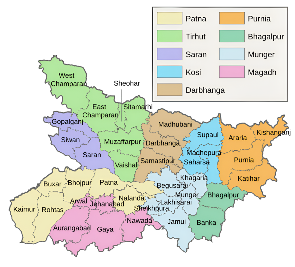
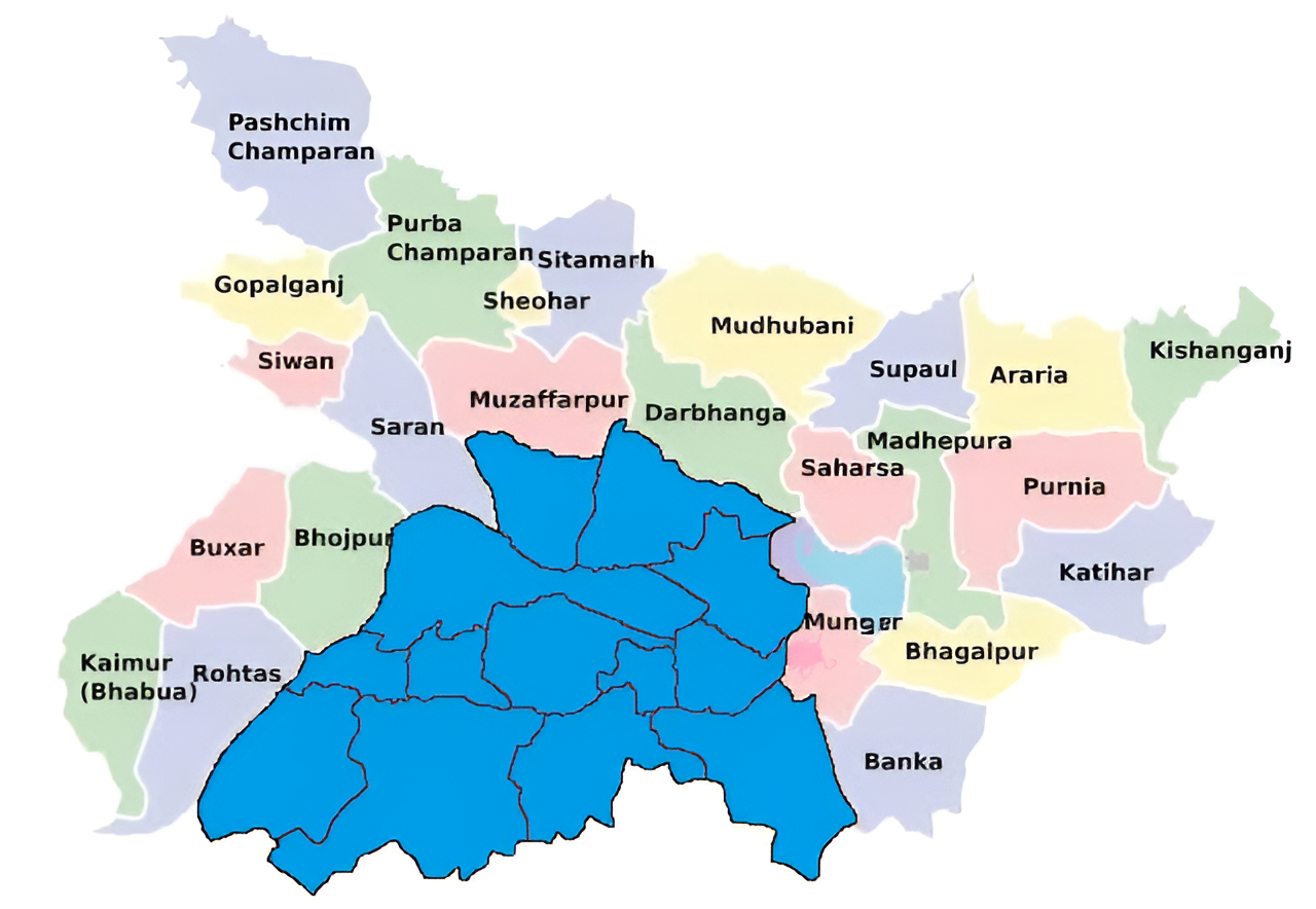
Magadh Division and Its Districts
Magadh Division is one of Bihar’s most historically significant and culturally rich regions, located in the southern part of the state. It is a geographical and administrative unit in the state of Bihar, India. The region’s administrative headquarters is Gaya, and it includes the following districts: Gaya, Nawada, Aurangabad, Jehanabad and Arwal. Known as the cradle of ancient Indian civilizations and religions such as Buddhism and Jainism, Magadh holds an unparalleled legacy in the fields of politics, spirituality, and education. The division combines its glorious past with modern development efforts to emerge as a vital economic and cultural hub in Bihar.
Magadh Region
The Magadh region was once the core of several larger kingdoms and empires between the 6th century BCE and the 8th century CE. The region’s strategic location in the Ganges River valley allowed it to control trade and communication on the river. The region’s culture is known for its distinct language, folk songs, and festivals. The primary language of the region is Magahi.
The Magadh region was originally known as the Magadha mahajanpada. The region’s boundaries were the Gaṅgā, Son, and Campā rivers to the north, west, and east, respectively. The Vindhya mountains’ eastern spurs formed the southern border. The region’s initial territory is now the Patna and Gaya districts of Bihar.
Formation of Administrative Headquarters
The British acquired Gaya during the 1764 Battle of Buxar. In 1947, Gaya and other regions of the nation gained their independence. Up till 1864, Gaya was a part of the Behar and Ramgarh districts. In 1865, it was granted the status of an autonomous district. In 1976, the old Gaya district was divided into the districts of Aurangabad and Nawada.
The Bihar State Government then established the Magadh Division in May 1981, which included the districts of Gaya, Nawada, Aurangabad, and Jehanabad. When the Gaya district was established in 1865, all of these districts were at the subdivision level.
Key Facts About Magadh Division
- Country:
 India
India - State:
 Bihar
Bihar - Established: May 1981
- Coordinates: 24°45′N 85°00′E
- Area: 412345 km2 (4769 sq mi)
- Division Headquarters: Gaya
- Divisional Commissioner: Prem singh meena IAS
- Number of Districts: 5 (Gaya, Nawada, Aurangabad, Jehanabad, Arwal)
- Subdivisions: 10
- (Sadar, Sherghati, Tekari, Nimchak Bathani, Auranagabad, Daudnagar, Nawada, Rajauli, Jehanabad, Arwal)
- No. of Blocks: 61
- Gram Panchyat: 862 (approx)
- Villages: 7122 (approx)
- Population (2011): 10,931,018
- Rivers: Lilajan/Niranjana, Mohana, Punpun, Son
- Geography:
- Located in the southern region of Bihar, bordered by Jharkhand to the south.
- Characterized by hilly terrains, forests, and rivers like the Phalgu and Sone.
- Transports:
- NH-2, NH-31, NH-22, NH-96, NH-33 NH-82, NH-83
- Grand Chord
- Asansol–Gaya section
- Gaya–Mughalsarai section
- Lok Sabha constituencies: 4 (Aurangabad, Gaya, Jahanabad, Nawada)
- Vidhan Sabha constituencies: 26
- Arwal, Kurtha, Jehanabad, Ghosi, Makhdumpur, Aurangabad, Goh, Obra, Nabinagar, kutumba, Rafiganj, Nawada, Hisua, Rajauli, Gobindpur, Warisaliganj, Gurua, Sherghati, Imamganj, Barachatti, Bodh Gaya, Gaya Town, Tikari, Belaganj, Atri, Wazirganj
- Community development blocks: Konch, Deo Block
- Official Website: gaya.nic.in/divisions/magadh-commissionary/
Districts of Saran Division (Administrative Structure)
The Magadh Division comprises five districts:
1. Gaya District:
- Area: 4,976 km2 (1,921 sq mi)
- Population (2011): 4,359,700
- Literacy Rate: 63.67%
- District Headquarters: Gaya
- Gram Panchayats: 320
- Villages: 2886
- No. of Subdivision: 4 (Gaya Sadar, Tekari, Neemchak Bhatani, Sherghati)
- Police Station: 46
- No. of Blocks: 24
- Sadar Gaya, Belaganj, Wazirganj, Manpur, Bodh Gaya, Tankuppa, Fatehpur, Konch, Tekari, Guraru, Paraiya, Khizarsarai, Atri, Bhatani, Muhra, Gurua, Amas, Banke Bazar, Imamganj, Dumaria, Sherghati, Dobhi, Mohanpur, Barachatti.
- Municipal Corporation(Nagar Nigam): 1 (Gaya)
- Nagar Panchayat: 3 (Bodhgaya, Sherghati, Tekari)
- Lok Sabha constituency: 1 (Gaya)
- Vidhan Sabha constituencies: 10
- Gurua, Sherghati, Imamganj, Barachatti, Bodh Gaya, Gaya Town, Tikari, Belaganj, Atri, Wazirganj
- Key Features:
- A major pilgrimage site for Hindus and Buddhists.
- Home to Bodh Gaya, where Lord Buddha attained enlightenment under the Bodhi Tree, a UNESCO World Heritage Site.
- Known for Vishnupad Temple and Pind Daan rituals.
- Significance: A spiritual and religious hub with global recognition.
- Official Website: gaya.nic.in
2. Nawada District:
- Area: 2,494 km2 (963 sq mi)
- Population (2011): 2,219,146
- Literacy Rate: 59.76%
- District Headquarters: Nawada
- Gram Panchayats: 182
- Villages: 1099
- No. of Subdivision: 2 (Nawada, Rajauli)
- No. of Blocks: 14
- Hisua, Warisaliganj, Kawakol, Nawada, Nardiganj, Kashichak, Pakari Barawan, Akbarpur, Narhat, Meskaur, Sirdala, Rajauli, Govindpur, Roh.
- Police Station: 35
- Municipal Council (Nagar Parishad): 1 (Nawada)
- Nagar Panchayat: 3 (Hisua, Rajauli, Warisaliganj)
- Lok Sabha constituency: 1 (Nawada)
- Vidhan Sabha constituencies: 5 (Nawada, Hisua, Rajauli, Gobindpur & Warisaliganj).
- Key Features:
- A district with historical and religious importance.
- Notable landmarks include Kakolat Waterfall, a popular tourist attraction, and Pawapuri, where Lord Mahavira attained salvation.
- Agriculture is the backbone of the local economy, with the production of rice and oilseeds.
- Significance: A district with natural beauty and spiritual relevance.
- Official Website: nawada.nic.in
3. Aurangabad District:
- Area: 3,305 km2 (1,276 sq mi)
- Population (2011): 2,540,073
- Literacy Rate: 72.77%
- District Headquarters: Aurangabad
- Gram Panchayats: 202
- Villages: 1884
- No. of Subdivision: 2 (Aurangabad, Daudnagar)
- No. of Blocks: 11
- (Aurangabad, Barun, Navinagar, Kutumba, Madanpur, Deo, Rafiganj, Obra, Daudnagar, Goh, Haspura)
- Police Station: 32
- Municipal Corporation (Nagar Nigam): 2 (Aurangabad, Daudnagar)
- Nagar Panchayat: 4 (Barun, Nabinagar, Rafiganj, Deo)
- Lok Sabha constituency: 2 (Aurangabad, Karakat)
- Vidhan Sabha constituencies: 6
- Aurangabad, Goh, Obra, Nabinagar, kutumba, Rafiganj
- Key Features:
- Known as the “Chittorgarh of Bihar“, it has a strong historical legacy of bravery and valor.
- Home to ancient temples like Deo Sun Temple, which hosts the famous Chhath Puja.
- Agriculturally rich, producing wheat, paddy, and sugarcane.
- Significance: A district with historical and cultural importance.
- Official Website: aurangabad.bih.nic.in
4. Jehanabad District:
- Area: 932 km2 (360 sq mi)
- Population (2011): 1,125,313
- Literacy Rate: 78.27%
- District Headquarters: Jehanabad
- Gram Panchayats: 93
- Villages: 918
- No. of Subdivision: 1 (Jehanabad)
- No. of Blocks: 7 (Jehanabad, Makhdumpur, Ghosi, Hulasganj, Ratni Faridpur, Modanganj, Kako)
- Police Station: 13
- Tehta O.P., Okari O.P., Karauna O.P., Hulasganj, Pali, Makhdumpur, Kako, Kalpa O.P., Bhelawar O.P., Jehanabad, Ghosi, Sakurabad, Paras Bigha.
- Municipal Council (Nagar Parishad): 1( Jehanabad)
- Nagar Panchayat: Makhdumpur
- Lok Sabha constituency: 1 (Jehanabad)
- Vidhan Sabha constituencies: 3 (Jehanabad, Ghosi, Makhdumpur)
- Key Features:
- Primarily an agricultural district producing paddy, wheat, and pulses.
- Known for its association with historical and cultural traditions.
- Important landmarks include Barabar Caves, ancient rock-cut caves linked to the Mauryan period.
- Significance: A blend of agricultural and historical importance.
- Official Website: jehanabad.nic.in
5. Arwal District:
- Area: 638 km2 (246 sq mi)
- Population (2011): 700,843
- Literacy Rate: 69.54%
- District Headquarters: Arwal
- Gram Panchayats: 65
- Villages: 335
- No. of Subdivision: 1 (Arwal Sadar)
- No. of Blocks: 5 (Arwal, Kaler, Karpi, Kurtha, Sonbhadra Banshi Suryapur)
- Police Station: 11
- Arwal, Rampur Chauram, Parasi, Mehndia, Kaler, karpi, Kurtha, Kinjer, Banshi OP, Manikpur OP, Shahertelpa OP
- Municipal Council (Nagar Parishad): 1 (Jehanabad)
- Nagar Panchayat: 1 (Kurtha)
- Lok Sabha constituency: 1 (Jahanabad)
- Vidhan Sabha constituencies: 2 (Arwal and Kurtha)
- Key Features:
- Smallest district in the division, primarily agrarian.
- Known for its contribution to the rural economy of Bihar.
- Culturally connected to Magadh’s rich traditions.
- Significance: Focused on agriculture and rural development.
- Official Website: arwal.nic.in
Each district is significant for its historical, cultural, and economic contributions to the division.
Geographical Overview
- Location: Magadh Division is located in south-central Bihar, bordered by the Ganga River to the north and Jharkhand to the south. It is named after the ancient Magadha Empire, which played a pivotal role in shaping Indian history.
- Rivers: The region is irrigated by the Falgu, Sone, and Punpun rivers, which contribute to its fertile agricultural land.
- Topography: The area consists of a mix of fertile plains and hilly terrains, with the Rajgir Hills and parts of the Chotanagpur Plateau adding to its geographical diversity.
- Climate: The division experiences a humid subtropical climate with hot summers, a monsoon season, and cool winters.
Historical Significance
- Ancient Period: Magadh was the core of the Magadha Empire, one of the 16 Mahajanapadas (ancient Indian kingdoms). It flourished under dynasties like the Mauryas and Guptas, with rulers such as Chandragupta Maurya and Ashoka leaving an indelible mark on Indian history.
- Buddhism and Jainism: The division is closely associated with the rise of Buddhism and Jainism. Bodh Gaya, the site where Lord Buddha attained enlightenment, is a UNESCO World Heritage Site. Jainism also has deep roots in the region, with Rajgir being an important pilgrimage site.
- Medieval Period: The division saw various dynasties, including the Delhi Sultanate, Mughals, and local rulers, contributing to its architectural and cultural heritage.
- Modern Period: During British rule, Gaya emerged as a key educational and administrative center. The region also played a role in India’s independence movement.
Cultural Significance
- Spiritual Hub: Magadh is revered as a spiritual epicenter due to its connection with Buddhism, Jainism, and Hinduism. It attracts pilgrims and tourists from across the globe.
- Languages: Commonly spoken languages include Hindi, Magahi, Urdu, and Pali (in religious contexts).
- Festivals: Festivals such as Chhath Puja, Buddha Purnima, Mahavir Jayanti, and Durga Puja are celebrated with great enthusiasm.
- Cuisine: Magadh is known for traditional dishes like litti chokha, pitha, sattu paratha, and sweets like tilkut and kesaria peda.
Economy
- Agriculture: Agriculture forms the backbone of Magadh’s economy, with key crops including rice, wheat, pulses, and oilseeds. The fertile plains and river irrigation systems enhance productivity.
- Tourism: The division is a global tourism hotspot, particularly for religious tourism. Sites like Bodh Gaya, Rajgir, and Nalanda attract millions of visitors annually, boosting the local economy.
- Industries:
- Small-scale industries related to handloom, handicrafts, and agro-processing are prevalent.
- Tourism-related businesses like hospitality, transportation, and guide services are significant contributors.
- Mining: The hilly areas of Aurangabad and Nawada are rich in mineral resources, including stone and sand, which support construction-related industries.
- Livelihood: Besides farming and tourism, residents engage in small-scale industries, trade, and public services. Migration for employment to other parts of India is also common.
Education and Institutions
- Key Institutions:
- Magadh University (Bodh Gaya): One of the largest universities in Bihar, offering higher education in various disciplines.
- Central University of South Bihar (Gaya): A prestigious institution for higher education and research.
- Bihar Institute of Mental Health and Allied Sciences (Nawada): A specialized medical institute.
- Historical Significance in Education:
- The division is close to Nalanda University, an ancient seat of learning, and Vikramshila University, showcasing Magadh’s legacy in education.
- Challenges: Despite its historical reputation, rural literacy rates remain low, and educational infrastructure in remote areas needs improvement.
Transportation and Connectivity
- Railways: The division is well-connected by the Indian Railways, with Gaya Junction being a major railway hub linking it to Delhi, Kolkata, and Patna.
- Roadways: National highways, including NH-2 (Grand Trunk Road) and NH-83, connect Magadh to other parts of Bihar and neighboring states. However, rural roads often require maintenance.
- Airways: The Gaya International Airport is one of the few international airports in Bihar, catering to tourists from countries like Japan, Thailand, and Sri Lanka.
- Local Transport: Public and private buses, autos, and cycle rickshaws are common means of local transportation.
Tourism
Magadh Division is one of India’s premier tourism regions, blending spirituality, history, and natural beauty:
- Bodh Gaya (Gaya): A UNESCO World Heritage Site where Buddha attained enlightenment under the Bodhi Tree. Key attractions include the Mahabodhi Temple, Bodhi Tree, and several international monasteries.
- Rajgir (Nalanda District): Known for its hot springs, Vishwa Shanti Stupa, Griddhakuta Hill, and sites associated with Lord Buddha and Mahavira.
- Barabar Caves (Jehanabad): The oldest rock-cut caves in India, associated with the Mauryan period.
- Vikramshila and Nalanda Ruins: Although technically outside the division, these sites are culturally and historically tied to Magadh.
- Aurangabad Temples: Famous for religious and historical temples like Amjhar Sharif Dargah and Deo Sun Temple.
Challenges
- Infrastructure Gaps: While urban centers like Gaya are developing, rural areas lack reliable roads, healthcare, and electricity.
- Flooding and Drought: The division faces seasonal flooding from rivers and occasional drought conditions, affecting agriculture.
- Tourism Management: Infrastructure for managing the high tourist inflow in Bodh Gaya and Rajgir requires improvement.
- Educational Access: Educational opportunities are limited in rural areas, contributing to lower literacy rates.
Development Initiatives
- Bodh Gaya Development Plan: Focused on enhancing infrastructure, security, and tourist facilities at the UNESCO World Heritage Site.
- Skill Development: Programs are being launched to promote skills in tourism, hospitality, and traditional crafts.
- Road and Rail Connectivity: Investments in upgrading highways and railways to boost trade and tourism.
- Flood Control Projects: Efforts are being made to improve embankments and flood management systems.
- Promotion of Ecotourism: Initiatives to develop Rajgir’s natural hot springs and forested areas as eco-tourism destinations.
Key Highlights
- Ancient Legacy: Magadh Division is the heartland of ancient Indian civilizations and a global center for Buddhist and Jain pilgrimages.
- Tourism Hub: The division attracts millions of international and domestic tourists, especially to Bodh Gaya and Rajgir.
- Economic Potential: With its fertile plains, mineral resources, and booming tourism sector, the division has significant economic opportunities.
- Cultural Identity: Magadh’s rich blend of history, religion, and culture makes it one of the most unique regions in India.
Conclusion
Magadh Division stands as a testament to Bihar’s historical and cultural grandeur. Its districts, particularly Gaya and Nawada, serve as centers for spiritual tourism, while agriculture drives the local economy. Known for its ancient empires, spiritual significance, and global tourism appeal, it holds immense potential for development. While challenges like infrastructure gaps and environmental concerns persist, focused initiatives in education, tourism, and economic development can help Magadh reclaim its historical stature as a leading center of progress and enlightenment.
Would you like more details about any specific Topics on Bihar? Comment Below 😊
मगध प्रमंडल और इसके जिले
मगध प्रमंडल बिहार के सबसे ऐतिहासिक रूप से महत्वपूर्ण और सांस्कृतिक रूप से समृद्ध क्षेत्रों में से एक है, जो राज्य के दक्षिणी भाग में स्थित है। यह भारत के बिहार राज्य में एक भौगोलिक और प्रशासनिक इकाई है। इस क्षेत्र का प्रशासनिक मुख्यालय गया है, और इसमें निम्नलिखित जिले शामिल हैं: गया, नवादा, औरंगाबाद, जहानाबाद और अरवल। प्राचीन भारतीय सभ्यताओं और बौद्ध धर्म और जैन धर्म जैसे धर्मों के उद्गम स्थल के रूप में जाना जाने वाला मगध राजनीति, आध्यात्मिकता और शिक्षा के क्षेत्र में एक अद्वितीय विरासत रखता है। यह प्रमंडल अपने गौरवशाली अतीत को आधुनिक विकास प्रयासों के साथ जोड़कर बिहार में एक महत्वपूर्ण आर्थिक और सांस्कृतिक केंद्र के रूप में उभरता है।
6वीं -8वीं शताब्दी
मगध क्षेत्र कभी 6वीं शताब्दी ईसा पूर्व और 8वीं शताब्दी ईस्वी के बीच कई बड़े राज्यों और साम्राज्यों का केंद्र था। गंगा नदी घाटी में इस क्षेत्र की रणनीतिक स्थिति ने इसे नदी पर व्यापार और संचार को नियंत्रित करने की अनुमति दी। इस क्षेत्र की संस्कृति अपनी विशिष्ट भाषा, लोकगीतों और त्योहारों के लिए जानी जाती है। इस क्षेत्र की प्राथमिक भाषा मगही है।
मगध क्षेत्र को मूल रूप से मगध महाजनपद के नाम से जाना जाता था। इस क्षेत्र की सीमाएँ क्रमशः उत्तर, पश्चिम और पूर्व में गंगा, सोन और कैम्पा नदियाँ थीं। विंध्य पर्वत की पूर्वी चोटियाँ दक्षिणी सीमा बनाती थीं। इस क्षेत्र का प्रारंभिक क्षेत्र अब बिहार के पटना और गया जिले हैं।
प्रशासनिक मुख्यालय का गठन
अंग्रेजों ने 1764 में बक्सर की लड़ाई के दौरान गया पर कब्ज़ा कर लिया। 1947 में गया और देश के अन्य क्षेत्रों ने अपनी स्वतंत्रता प्राप्त की। 1864 तक गया बिहार और रामगढ़ जिलों का हिस्सा था। 1865 में इसे एक स्वायत्त जिले का दर्जा दिया गया। 1976 में पुराने गया जिले को औरंगाबाद और नवादा जिलों में विभाजित कर दिया गया।
इसके बाद बिहार राज्य सरकार ने मई 1981 में मगध डिवीजन की स्थापना की, जिसमें गया, नवादा, औरंगाबाद और जहानाबाद जिले शामिल थे। 1865 में जब गया जिले की स्थापना हुई थी, तब ये सभी जिले अनुमंडल स्तर पर थे।
मगध प्रमंडल के बारे में मुख्य तथ्य
- देश: भारत
- राज्य: बिहार
- स्थापना: May 1981
- निर्देशांक: 24°45′N 85°00′E
- क्षेत्र: 412345 वर्ग किमी (4769 वर्ग मील)
- प्रमंडल मुख्यालय: गया
- संभागीय आयुक्त: प्रेम सिंह मीना आईएएस
- जिलों की संख्या: 5 (गया, नवादा, औरंगाबाद, जहानाबाद, अरवल)
- अनुमंडल: 10
- (सदर, शेरघाटी, टेकारी, नीमचक बथानी, औरंगाबाद, दाउदनगर, नवादा, रजौली, जहानाबाद, अरवल)
- ब्लॉकों की संख्या: 61
- ग्राम पंचायत: 862 (लगभग)
- गाँव: 7122 (लगभग)
- जनसंख्या (2011): 10,931,018
- नदियाँ: लीलाजन/निरंजना, मोहना, पुनपुन, सोन
- भूगोल:
- बिहार के दक्षिणी क्षेत्र में स्थित, दक्षिण में झारखंड की सीमा से लगा हुआ।
- पहाड़ी इलाकों, जंगलों और फल्गु और सोन जैसी नदियों से इसकी पहचान है।
- परिवहन:
- NH-2, NH-31, NH-22, NH-96, NH-33 NH-82, NH-83
- ग्रैंड कॉर्ड
- आसनसोल-गया खंड
- गया-मुगलसराय खंड
- लोकसभा निर्वाचन क्षेत्र: 4 (औरंगाबाद, गया, जहानाबाद, नवादा)
- विधानसभा निर्वाचन क्षेत्र: 26
- अरवल, कुर्था, जहानाबाद, घोसी, मखदुमपुर, औरंगाबाद, गोह, ओबरा, नबीनगर, कुटुंबा, रफीगंज, नवादा, हिसुआ, रजौली, गोबिंदपुर, वारिसलीगंज, गुरुआ, शेरघाटी, इमामगंज, बाराचट्टी, बोधगया, गया टाउन, टिकारी, बेलागंज, अत्रि, वजीरगंज
- सामुदायिक विकास खंड: कोंच, देव प्रखंड
- आधिकारिक वेबसाइट: gaya.nic.in/divisions/magadh-commissionary/
सारण प्रमंडल के जिले (प्रशासनिक संरचना)
मगध प्रमंडल में पांच जिले शामिल हैं:
1. गया जिला:
- क्षेत्रफल: 4,976 वर्ग किमी (1,921 वर्ग मील)
- जनसंख्या (2011): 4,359,700
- साक्षरता दर: 63.67%
- जिला मुख्यालय: गया
- ग्राम पंचायतें: 320
- गाँव: 2886
- अनुमण्डल की संख्या: 4 (गया सदर, टेकारी, नीमचक भटानी, शेरघाटी)
- पुलिस स्टेशन: 46
- ब्लॉकों की संख्या: 24
- सदर गया, बेलागंज, वजीरगंज, मानपुर, बोधगया, टनकुप्पा, फतेहपुर, कोंच, टेकारी, गुरारू, परैया, खिजरसराय, अतरी, भटनी, मुहरा, गुरुआ, आमस, बांके बाजार, इमामगंज, डुमरिया, शेरघाटी, डोभी, मोहनपुर, बाराचट्टी .
- नगर निगम: 1 (गया)
- नगर पंचायत: 3 (बोधगया, शेरघाटी, टेकारी)
- लोकसभा क्षेत्र: 1 (गया)
- विधान सभा क्षेत्र: 10
- गुरुआ, शेरघाटी, इमामगंज, बाराचट्टी, बोधगया, गया टाउन, टिकारी, बेलागंज, अतरी, वजीरगंज
- प्रमुख विशेषताऐं:
- हिंदुओं और बौद्धों के लिए एक प्रमुख तीर्थ स्थल।
- बोधगया का घर, जहां भगवान बुद्ध को बोधि वृक्ष के नीचे ज्ञान प्राप्त हुआ था, जो यूनेस्को की विश्व धरोहर स्थल है।
- विष्णुपद मंदिर और पिंडदान अनुष्ठान के लिए जाना जाता है।
- महत्व: वैश्विक मान्यता वाला आध्यात्मिक और धार्मिक केंद्र।
- आधिकारिक वेबसाइट: gaya.nic.in
2. नवादा जिला:
- क्षेत्रफल: 2,494 वर्ग किमी (963 वर्ग मील)
- जनसंख्या (2011): 2,219,146
- साक्षरता दर: 59.76%
- जिला मुख्यालय: नवादा
- ग्राम पंचायतें: 182
- गाँव: 1099
- अनुमण्डल की संख्या: 2 (नवादा, रजौली)
- ब्लॉकों की संख्या: 14
- हिसुआ, वारिसलीगंज, कौवाकोल, नवादा, नारदीगंज, काशीचक, पकरीबरावां, अकबरपुर, नरहट, मेसकौर, सिरदला, रजौली, गोविंदपुर, रोह.
- पुलिस स्टेशन: 35
- नगर परिषद: 1 (नवादा)
- नगर पंचायत: 3 (हिसुआ, रजौली, वारिसलीगंज)
- लोकसभा निर्वाचन क्षेत्र: 1 (नवादा)
- विधानसभा निर्वाचन क्षेत्र: 5 (नवादा, हिसुआ, रजौली, गोविंदपुर और वारिसलीगंज। )
- मुख्य विशेषताएँ:
- ऐतिहासिक और धार्मिक महत्व वाला जिला।
- उल्लेखनीय स्थलों में काकोलत झरना, एक लोकप्रिय पर्यटक आकर्षण और पावापुरी शामिल हैं, जहाँ भगवान महावीर ने मोक्ष प्राप्त किया था।
- कृषि स्थानीय अर्थव्यवस्था की रीढ़ है, जिसमें चावल और तिलहन का उत्पादन होता है।
- महत्व: प्राकृतिक सौंदर्य और आध्यात्मिक प्रासंगिकता वाला एक जिला।
- आधिकारिक वेबसाइट: nawada.nic.in
3. औरंगाबाद जिला:
- क्षेत्रफल: 3,305 वर्ग किमी (1,276 वर्ग मील)
- जनसंख्या (2011): 2,540,073
- साक्षरता दर: 72.77%
- जिला मुख्यालय: औरंगाबाद
- ग्राम पंचायतें: 202
- गाँव: 1884
- अनुमंडल की संख्या: 2 (औरंगाबाद, दाउदनगर)
- ब्लॉकों की संख्या: 11
- (औरंगाबाद, बारुण, नवीनगर, कुटुम्बा, मदनपुर, देव, रफीगंज, ओबरा, दाउदनगर, गोह, हसपुरा)
- पुलिस स्टेशन: 32
- नगर निगम: 2 (औरंगाबाद, दाउदनगर)
- नगर पंचायत: 4 (बारुण, नबीनगर, रफीगंज, देव)
- लोकसभा क्षेत्र: 2 (औरंगाबाद, काराकाट)
- विधान सभा क्षेत्र: 6
- औरंगाबाद, गोह, ओबरा, नबीनगर, कुटुम्बा, रफीगंज
- मुख्य विशेषताएं:
- “बिहार के चित्तौड़गढ़” के रूप में जाना जाता है, इसमें बहादुरी और वीरता की एक मजबूत ऐतिहासिक विरासत है।
- देव सूर्य मंदिर जैसे प्राचीन मंदिरों का घर, जहाँ प्रसिद्ध छठ पूजा का आयोजन किया जाता है .
- कृषि की दृष्टि से समृद्ध, गेहूं, धान और गन्ना उत्पादन।
- महत्व: ऐतिहासिक और सांस्कृतिक महत्व वाला जिला।
- आधिकारिक वेबसाइट: aurangabad.bih.nic.in
4. जहानाबाद जिला:
- क्षेत्रफल: 932 वर्ग किमी (360 वर्ग मील)
- जनसंख्या (2011): 1,125,313
- साक्षरता दर: 78.27%
- जिला मुख्यालय: जहानाबाद
- ग्राम पंचायतें: 93
- गांव: 918
- अनुमंडल की संख्या: 1 (जहानाबाद)
- ब्लॉकों की संख्या: 7 (जहानाबाद, मखदुमपुर, घोसी, हुलासगंज, रतनी फरीदपुर, मोदनगंज, काको)
- पुलिस स्टेशन: 13
- टेहटा ओपी, ओकरी ओपी, करौना ओपी, हुलासगंज, पाली, मखदुमपुर, काको, कल्पा ओपी, भेलावर ओपी, जहानाबाद, घोसी, सकुराबाद, परस बिगहा।
- नगर परिषद: 1 (जहानाबाद)
- नगर पंचायत: मखदुमपुर
- लोकसभा निर्वाचन क्षेत्र: 1 (जहानाबाद)
- विधानसभा निर्वाचन क्षेत्र: 3 (जहानाबाद, घोसी, मखदुमपुर)
- मुख्य विशेषताएं:
- मुख्य रूप से धान, गेहूं और दालों का उत्पादन करने वाला एक कृषि जिला।
- ऐतिहासिक और सांस्कृतिक परंपराओं के साथ अपने जुड़ाव के लिए जाना जाता है।
- महत्वपूर्ण स्थलों में बराबर गुफाएँ, मौर्य काल से जुड़ी प्राचीन चट्टान-काट गुफाएँ शामिल हैं।
- महत्व: कृषि और ऐतिहासिक महत्व का मिश्रण।
- आधिकारिक वेबसाइट: jehanabad.nic.in
5. अरवल जिला:
- क्षेत्रफल: 638 किमी2 (246 वर्ग मील)
- जनसंख्या (2011): 700,843
- साक्षरता दर: 69.54%
- जिला मुख्यालय: अरवल
- ग्राम पंचायतें: 65
- गाँव: 335
- अनुमण्डल की संख्या: 1 (अरवल सदर)
- ब्लॉकों की संख्या: 5 (अरवल, कलेर, करपी, कुर्था, सोनभद्र बंशी सूर्यपुर)
- पुलिस स्टेशन: 11
- अरवल, रामपुर चौरम, परासी, मेहंदिया, कलेर, करपी, कुर्था, किंजर, बंशी ओपी, मानिकपुर ओपी, शहरतेलपा ओपी
- नगर परिषद: 1 (जहानाबाद)
- नगर पंचायत: 1 (कुर्था)
- लोकसभा क्षेत्र: 1 (जहानाबाद)
- विधान सभा क्षेत्र: 2 (अरवल और कुर्था)
- मुख्य विशेषताएं:
- संभाग का सबसे छोटा जिला, मुख्य रूप से कृषि प्रधान।
- बिहार की ग्रामीण अर्थव्यवस्था में अपने योगदान के लिए जाना जाता है।
- मगध की समृद्ध परंपराओं से सांस्कृतिक रूप से जुड़ा हुआ है।
- महत्व: कृषि और ग्रामीण विकास पर केंद्रित।
- आधिकारिक वेबसाइट: arwal.nic.in
प्रत्येक जिला महत्वपूर्ण है प्रभाग में इसके ऐतिहासिक, सांस्कृतिक और आर्थिक योगदान के लिए।
भौगोलिक अवलोकन
- स्थान: मगध प्रमंडल दक्षिण-मध्य बिहार में स्थित है, जिसकी सीमा उत्तर में गंगा नदी और दक्षिण में झारखंड से लगती है। इसका नाम प्राचीन मगध साम्राज्य के नाम पर रखा गया है, जिसने भारतीय इतिहास को आकार देने में महत्वपूर्ण भूमिका निभाई थी।
- नदियाँ: इस क्षेत्र की सिंचाई फल्गु, सोन और पुनपुन नदियों द्वारा की जाती है, जो इसकी उपजाऊ कृषि भूमि में योगदान करती हैं।
- स्थलाकृति: इस क्षेत्र में उपजाऊ मैदान और पहाड़ी इलाके हैं, जिसमें राजगीर की पहाड़ियाँ और छोटानागपुर पठार के कुछ हिस्से इसकी भौगोलिक विविधता को बढ़ाते हैं।
- जलवायु: इस प्रमंडल में गर्म ग्रीष्मकाल, मानसून का मौसम और ठंडी सर्दियाँ के साथ आर्द्र उपोष्णकटिबंधीय जलवायु होती है।
ऐतिहासिक महत्व
- प्राचीन काल: मगध, मगध साम्राज्य का केंद्र था, जो 16 महाजनपदों (प्राचीन भारतीय राज्यों) में से एक था। यह मौर्य और गुप्त जैसे राजवंशों के अधीन फला-फूला, जिसमें चंद्रगुप्त मौर्य और अशोक जैसे शासकों ने भारतीय इतिहास पर एक अमिट छाप छोड़ी।
- बौद्ध धर्म और जैन धर्म: यह विभाजन बौद्ध धर्म और जैन धर्म के उदय से निकटता से जुड़ा हुआ है। बोधगया, वह स्थान जहाँ भगवान बुद्ध ने ज्ञान प्राप्त किया था, यूनेस्को की विश्व धरोहर स्थल है। जैन धर्म की भी इस क्षेत्र में गहरी जड़ें हैं, जिसमें राजगीर एक महत्वपूर्ण तीर्थ स्थल है।
- मध्यकालीन काल: इस विभाजन में दिल्ली सल्तनत, मुगलों और स्थानीय शासकों सहित विभिन्न राजवंशों ने अपनी वास्तुकला और सांस्कृतिक विरासत में योगदान दिया।
- आधुनिक काल: ब्रिटिश शासन के दौरान, गया एक प्रमुख शैक्षिक और प्रशासनिक केंद्र के रूप में उभरा। इस क्षेत्र ने भारत के स्वतंत्रता आंदोलन में भी भूमिका निभाई।
सांस्कृतिक महत्व
- आध्यात्मिक केंद्र: बौद्ध धर्म, जैन धर्म और हिंदू धर्म से जुड़े होने के कारण मगध को आध्यात्मिक केंद्र के रूप में जाना जाता है। यह दुनिया भर से तीर्थयात्रियों और पर्यटकों को आकर्षित करता है।
- भाषाएँ: आम तौर पर बोली जाने वाली भाषाओं में हिंदी, मगही, उर्दू और पाली (धार्मिक संदर्भों में) शामिल हैं।
- त्यौहार: छठ पूजा, बुद्ध पूर्णिमा, महावीर जयंती और दुर्गा पूजा जैसे त्यौहार बहुत उत्साह के साथ मनाए जाते हैं।
- खाना: मगध लिट्टी चोखा, पीठा, सत्तू पराठा और तिलकुट और केसरिया पेड़ा जैसी मिठाइयों जैसे पारंपरिक व्यंजनों के लिए जाना जाता है।
अर्थव्यवस्था
- कृषि: चावल, गेहूँ, दालें और तिलहन जैसी प्रमुख फ़सलों के साथ कृषि मगध की अर्थव्यवस्था की रीढ़ है। उपजाऊ मैदान और नदी सिंचाई प्रणाली उत्पादकता को बढ़ाती है।
- पर्यटन: यह प्रभाग विशेष रूप से धार्मिक पर्यटन के लिए एक वैश्विक पर्यटन स्थल है। बोधगया, राजगीर और नालंदा जैसी जगहें सालाना लाखों पर्यटकों को आकर्षित करती हैं, जिससे स्थानीय अर्थव्यवस्था को बढ़ावा मिलता है।
- उद्योग:
- हथकरघा, हस्तशिल्प और कृषि प्रसंस्करण से संबंधित छोटे पैमाने के उद्योग प्रचलित हैं।
- पर्यटन से संबंधित व्यवसाय जैसे आतिथ्य, परिवहन और गाइड सेवाएँ महत्वपूर्ण योगदान देती हैं।
- खनन: औरंगाबाद और नवादा के पहाड़ी इलाके पत्थर और रेत सहित खनिज संसाधनों से समृद्ध हैं, जो निर्माण से संबंधित उद्योगों का समर्थन करते हैं।
- आजीविका: खेती और पर्यटन के अलावा, निवासी छोटे पैमाने के उद्योगों, व्यापार और सार्वजनिक सेवाओं में संलग्न हैं। भारत के अन्य हिस्सों में रोजगार के लिए पलायन भी आम है।
शिक्षा और संस्थान
- प्रमुख संस्थान:
- मगध विश्वविद्यालय (बोधगया): बिहार के सबसे बड़े विश्वविद्यालयों में से एक, जो विभिन्न विषयों में उच्च शिक्षा प्रदान करता है।
- दक्षिण बिहार केंद्रीय विश्वविद्यालय (गया): उच्च शिक्षा और शोध के लिए एक प्रतिष्ठित संस्थान।
- बिहार मानसिक स्वास्थ्य और संबद्ध विज्ञान संस्थान (नवादा): एक विशेष चिकित्सा संस्थान।
- शिक्षा में ऐतिहासिक महत्व:
- यह प्रभाग नालंदा विश्वविद्यालय, जो शिक्षा का एक प्राचीन केंद्र है, और विक्रमशिला विश्वविद्यालय के करीब है, जो शिक्षा में मगध की विरासत को दर्शाता है।
- चुनौतियाँ: अपनी ऐतिहासिक प्रतिष्ठा के बावजूद, ग्रामीण साक्षरता दर कम है, और दूरदराज के क्षेत्रों में शैक्षिक बुनियादी ढांचे में सुधार की आवश्यकता है।
परिवहन और संपर्क
- रेलवे: यह मंडल भारतीय रेलवे द्वारा अच्छी तरह से जुड़ा हुआ है, गया जंक्शन एक प्रमुख रेलवे हब है जो इसे दिल्ली, कोलकाता और पटना से जोड़ता है।
- सड़क मार्ग: NH-2 (ग्रैंड ट्रंक रोड) और NH-83 सहित राष्ट्रीय राजमार्ग मगध को बिहार के अन्य हिस्सों और पड़ोसी राज्यों से जोड़ते हैं। हालाँकि, ग्रामीण सड़कों को अक्सर रखरखाव की आवश्यकता होती है।
- वायुमार्ग: गया अंतर्राष्ट्रीय हवाई अड्डा बिहार के कुछ अंतरराष्ट्रीय हवाई अड्डों में से एक है, जो जापान, थाईलैंड और श्रीलंका जैसे देशों के पर्यटकों को आकर्षित करता है।
- स्थानीय परिवहन: सार्वजनिक और निजी बसें, ऑटो और साइकिल रिक्शा स्थानीय परिवहन के सामान्य साधन हैं।
पर्यटन
मगध संभाग भारत के प्रमुख पर्यटन क्षेत्रों में से एक है, जिसमें आध्यात्मिकता, इतिहास और प्राकृतिक सुंदरता का मिश्रण है:
- बोधगया (गया): यूनेस्को की विश्व धरोहर स्थल जहाँ बुद्ध ने बोधि वृक्ष के नीचे ज्ञान प्राप्त किया था। मुख्य आकर्षणों में महाबोधि मंदिर, बोधि वृक्ष और कई अंतरराष्ट्रीय मठ शामिल हैं।
- राजगीर (नालंदा जिला): अपने गर्म झरनों, विश्व शांति स्तूप, गृद्धकूट पहाड़ी और भगवान बुद्ध और महावीर से जुड़े स्थलों के लिए जाना जाता है।
- बराबर गुफाएँ (जहानाबाद): भारत में सबसे पुरानी चट्टान-काट गुफाएँ, मौर्य काल से जुड़ी हैं।
- विक्रमशिला और नालंदा खंडहर: हालाँकि तकनीकी रूप से संभाग के बाहर हैं, लेकिन ये स्थल सांस्कृतिक और ऐतिहासिक रूप से मगध से जुड़े हुए हैं।
- औरंगाबाद मंदिर: अमझर शरीफ दरगाह और देव सूर्य मंदिर जैसे धार्मिक और ऐतिहासिक मंदिरों के लिए प्रसिद्ध हैं।
चुनौतियाँ
- बुनियादी ढाँचे की कमी: गया जैसे शहरी केंद्र विकसित हो रहे हैं, जबकि ग्रामीण क्षेत्रों में विश्वसनीय सड़कों, स्वास्थ्य सेवा और बिजली की कमी है।
- बाढ़ और सूखा: प्रभाग नदियों से मौसमी बाढ़ और कभी-कभी सूखे की स्थिति का सामना करता है, जिससे कृषि प्रभावित होती है।
- पर्यटन प्रबंधन: बोधगया और राजगीर में पर्यटकों की उच्च आमद को प्रबंधित करने के लिए बुनियादी ढाँचे में सुधार की आवश्यकता है।
- शैक्षणिक पहुँच: ग्रामीण क्षेत्रों में शिक्षा के अवसर सीमित हैं, जिससे साक्षरता दर कम हो रही है।
विकास पहल
- बोधगया विकास योजना: यूनेस्को विश्व धरोहर स्थल पर बुनियादी ढांचे, सुरक्षा और पर्यटक सुविधाओं को बढ़ाने पर ध्यान केंद्रित किया गया।
- कौशल विकास: पर्यटन, आतिथ्य और पारंपरिक शिल्प में कौशल को बढ़ावा देने के लिए कार्यक्रम शुरू किए जा रहे हैं।
- सड़क और रेल संपर्क: व्यापार और पर्यटन को बढ़ावा देने के लिए राजमार्गों और रेलवे को उन्नत करने में निवेश।
- बाढ़ नियंत्रण परियोजनाएँ: तटबंधों और बाढ़ प्रबंधन प्रणालियों को बेहतर बनाने के प्रयास किए जा रहे हैं।
- पारिस्थितिकी पर्यटन को बढ़ावा: राजगीर के प्राकृतिक गर्म झरनों और वन क्षेत्रों को पारिस्थितिकी पर्यटन स्थलों के रूप में विकसित करने की पहल।
मुख्य विशेषताएँ
- प्राचीन विरासत: मगध प्रमंडल प्राचीन भारतीय सभ्यताओं का गढ़ है और बौद्ध तथा जैन तीर्थयात्राओं का वैश्विक केंद्र है।
- पर्यटन केंद्र: यह प्रमंडल लाखों अंतरराष्ट्रीय और घरेलू पर्यटकों को आकर्षित करता है, खास तौर पर बोधगया और राजगीर में।
- आर्थिक संभावना: अपने उपजाऊ मैदानों, खनिज संसाधनों और तेजी से बढ़ते पर्यटन क्षेत्र के साथ, इस प्रमंडल में महत्वपूर्ण आर्थिक अवसर हैं।
- सांस्कृतिक पहचान: मगध का इतिहास, धर्म और संस्कृति का समृद्ध मिश्रण इसे भारत के सबसे अनोखे क्षेत्रों में से एक बनाता है।
निष्कर्ष
मगध प्रमंडल बिहार की ऐतिहासिक और सांस्कृतिक भव्यता का प्रमाण है। इसके जिले, खास तौर पर गया और नवादा, आध्यात्मिक पर्यटन के केंद्र हैं, जबकि कृषि स्थानीय अर्थव्यवस्था को आगे बढ़ाती है। अपने प्राचीन साम्राज्यों, आध्यात्मिक महत्व और वैश्विक पर्यटन आकर्षण के लिए जाना जाने वाला यह प्रमंडल विकास की अपार संभावनाएं रखता है। जबकि बुनियादी ढांचे की कमी और पर्यावरण संबंधी चिंताओं जैसी चुनौतियां बनी हुई हैं, शिक्षा, पर्यटन और आर्थिक विकास में केंद्रित पहल मगध को प्रगति और ज्ञान के अग्रणी केंद्र के रूप में अपने ऐतिहासिक कद को पुनः प्राप्त करने में मदद कर सकती है।
क्या आप बिहार के किसी विशेष विषय के बारे में अधिक जानकारी चाहते हैं? नीचे टिप्पणी करें 😊
पदानुक्रमिक संरचना: बिहार का विस्तृत रोडमैप
बिहार में प्रमंडल और उसके जिलों का विवरण
Important Links
𝕋𝕙𝕒𝕟𝕜 𝕐𝕠𝕦 𝔽𝕠𝕣 𝕍𝕚𝕤𝕚𝕥𝕚𝕟𝕘 𝕆𝕦𝕣 𝕎𝕖𝕓𝕤𝕚𝕥𝕖𝕤 🙂
12 thoughts on “Magadh Division and its Special Districts of Bihar”