
Samastipur District: An Overview
Samastipur district, located in the northern part of Bihar, India, is an agriculturally rich district with historical, cultural, and economic significance. Moreover, it is well-known for its fertile land, industrial development, and strong transportation network, making it a vital district in Bihar’s growth story. In addition, it is the Divisional Headquarters of the North Eastern railway.
Specifically, the Samastipur district covering an area of 2,904 square kilometers (1,121 square miles). Particularly, the Bagmati River, which divides Samastipur from the Darbhanga district, forms its northern boundary. Furthermore, it shares borders with Vaishali and a portion of Muzaffarpur district on the west, the Ganges on the south, and Begusarai and a portion of Khagaria district on the east. Consequently, the district headquarters is located at Samastipur.
Additionally, Numerous rivers, including Budhi Gandak, Baya, Kosi, Kamla, Kareh, and Jhamwari and Balan, which are both branches of Burhi Gandak, flow through Samastipur district. On the south side of the district, the Ganges likewise avoids it.
Samastipur’s fertile plain contributes to its agricultural wealth. In particular, the primary crops are wheat, rice, maize, and tobacco. Moreover, Mango and leechi fruits are cultivated in large quantities. In addition, in Samsastipur, in Muktapur Village, there is a jute mill. With almost 5000 employees, Rameshwar Jute Mill is, particularly, a well-known jute mill. One of the greatest agricultural settlements is Shekhopur, which is also home to the well-known temple of Bhagwatisthan in Manipur.
Due to its large number of sugar mills, Samastipur is a major producer of sugar in the state. Additionally, the district is a significant producer of potatoes and it has about 20 cold storage facilities with a combined capacity of 650000 quintles for storing potatoes. Fertilizer use has also increased in Samastipur.
According to pages 33–34 of the Darbhanga district gazetteers Following a brief period of unrest, Darbhanga was ruled by the Oinwaras, commonly referred to as the Kameshwara Thakur or Sugauna Dynasty, from 1325 until 1525 AD. During this time, the Muslim invaders, who had by now taken over all of Mithila and whose achievements are documented, left these Hindu chiefs unaffected. Particularly, the Oinwara Dynasty is renowned for promoting learning and the arts, and as such, their court was the epicenter of Sanskrit belle’s philosophy and correspondence.
Gadadhara, Sankara, Vachaspati Mishra, Vidyapati, Amartakara, and Amiykara were among the eminent academics of the era. Furthermore, the dynasty’s progenitor, Kameshwara, lived in the Darbhanga District’s hamlet of Oini, close to Pusa Road. Subsequently, the Oinwara Raja moved his capital to Sugauna, which is close to Madhubani, after Hazi Ilyas of Bengal split Tirhut in two. Hazi Ilyas ruled the southern portion of the area, while the Oinwaras ruled the northern portion. Hazi Shamsuddin Ilyas of West Bengal established the present-day subdivision of Samastipur, which was once known as Shamsuddinpur. Eventually, after being separated from Darbhanga district in 1972, Samastipur became a district.
In addition, Samastipur has a modest, lovely, and secular culture, as well as folk melodies and famous Mithila paintings have long been sung and performed there at festivals and significant social events like marriage and birth rituals. Kathghorwa nach, natua nach dom domin, and jhijhia are among the folk dance forms that are also practiced. This region is also known for its famous Sama chakeva and Dom kach. Bhat dal and aaloo chokha are the happiest meals for all living things, while men’s dhoti kurtas and women’s sari and salwar kurtas are common attire. Overall, people of Samastipur mainly speak Hindi, Maithili and Angika languages.
Key Facts About Samastipur district
- Country:
 India
India - State:
 Bihar
Bihar - Established: 14th November, 1972
- Region: Mithila
- Division: Darbhanga
- Coordinates: 25.86319°N 85.78001°E
- Area: 2,904 km2 (1,121 sq mi)
- District Headquarters: Samastipur
- District Magistrate (DM): Shri Roshan Kushwaha, IAS
- Superintendent of Police (SP): Shri Ashok Mishra, IPS
- Population (2011):
- Total: 4,261,566
- Density: 1,500/km2 (3,800/sq mi)
- Literacy Rate: 61.86%
- Sex Ratio: 911 females/1000 males
- Gram Panchayats: 346
- Villages: 1260 (approx)
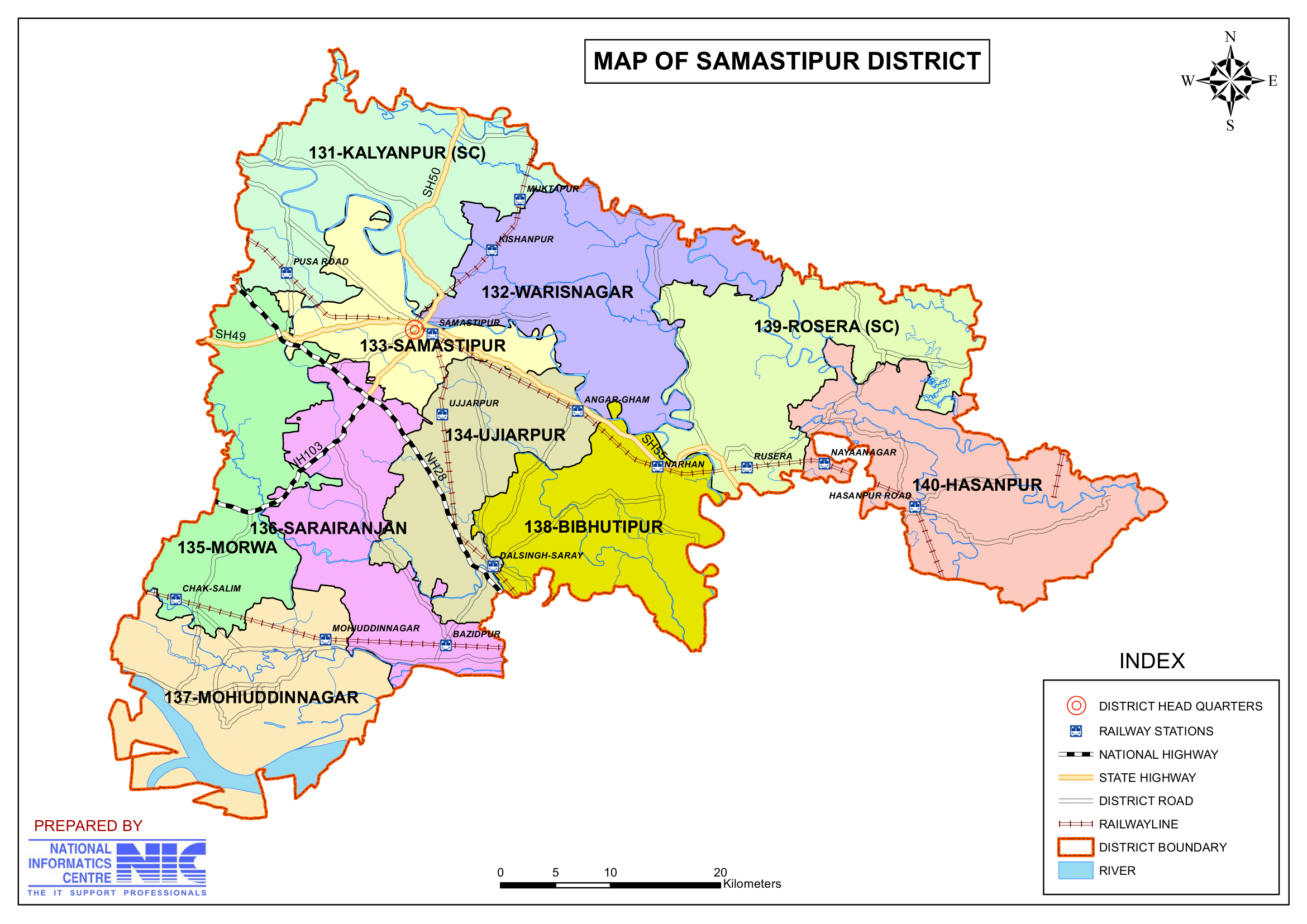
- Subdivisions: 4 (Samastipur Sadar, Dalsinghsarai, Rosera, Patori)
- No. of Blocks: 20
- Samastipur- Samastipur, Tajpur, Morwa, Khanpur, Kalyanpur, Sarairanjan, Pusa, Warisnagar
- Rosera- Rosera, Hasanpur, Bithan, Shivajinagar, Singhiya, Bibhutipur
- Dalsinghsarai- Dalsinghsarai, Ujiyarpur, Vidyapatinagar
- Patori- Patori, Mohanpur, Mohiuddinagar
- Police Station: 21
- Municipal Corporation (Nagar Nigam): 1 (Samastipur)
- Municipal Council (Nagar Parishad): 4 (Rosera, Dalsinghsarai, Tajpur, Shahpur Patori)
- Nagar Panchayat: 3 (Musrigharari, Sarairanjan, Singhiya)
- Rivers: Bagmati, Ganga, Burhi Gandak, Baya, Kosi, Kamla, Kareh, and Jhamwari and Balan, which are both the offshoots of Burhi Gandak.
- Lok Sabha constituency: 2 (Samastipur, Ujiarpur)
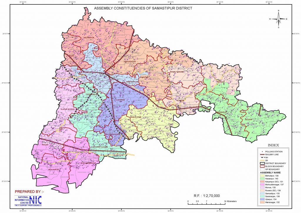
- Vidhan Sabha constituencies: 10
- 131- Kalyanpur, 132- Warisnagar, 133- Samastipur, 134- Ujiarpur, 135- Morwa, 136- Sarairanjan, 137- Mohiuddinnagar, 138- Bibhutipur, 139- Rosera, 140- Hasanpur
- Key Features:
- An agricultural district known for its production of sugarcane, rice, and maize.
- Famous for Khudiram Bose Memorial and Mangalgarh Fort.
- Houses several sugar mills and agro-based industries.
- Significance: A vital agricultural and industrial district in the region.
- Major Highways: NH-28, SH-88, SH-93, NH-122, NH-322
- Nearest Airport:
- Darbhnaga Airport (Approx 58 km. away from Dist. Headquarter)
- Jay Prakash Narayan International Airport Patna (Approx 100 km. away from Dist. Headquarter)
- Time Zone: UTC+05:30 (IST)
- PIN Code: 848101 (Samastipur)
- Vehicle Registration: BR33
- Official Website: samastipur.nic.in
Geography
- Location: Samastipur district lies in central Bihar, bordered by Darbhanga to the north, Begusarai to the south, Muzaffarpur to the west, and Khagaria to the east.
- Area: Samastipur district spans an area of approximately 2,905 square kilometers.
- Rivers: Samastipur district is traversed by several rivers, including the Ganga, Budhi Gandak, Bagmati, and Kamal Balan, which contribute to its fertile soil and agricultural prosperity.
- Climate: The district experiences a humid subtropical climate with hot summers, monsoon rains, and mild winters.
History
- Ancient Era: The region has historical connections with the ancient Mithila kingdom and is part of the broader Mithila region known for its rich cultural and literary heritage.
- Medieval Period: During the Mughal era, the region was known for its fertile plains and trade activities.
- Modern History: Samastipur was carved out as a separate district from Darbhanga in 1972. It has since grown into an important center for agriculture, trade, and education.
Demographics
- Population: As per the 2011 Census, Samastipur has a population of approximately 4.26 million.
- Literacy Rate: The district has a literacy rate of 61.86%, reflecting gradual improvement in education.
- Rank: 45th largest district in India out of 640.
- Population Density: 1,467 inhabitants per square kilometer (3,800/sq mi).
- Population Growth Rate (2001-2011): 25.53%.
- Sex Ratio: 911 females for every 1,000 males.
- Urban Population: 3.47% of the population lives in urban areas.
- Religious Composition (2011 Census):
- Hinduism: 89.18% of the population.
- Scheduled Castes: 18.85% of the population.
- Scheduled Tribes: 0.04% of the population.
- Islam: 10.62% of the population.
- Other/Not Stated: 0.20% of the population.
- Hinduism: 89.18% of the population.
- Languages Spoken: The primary language spoken is Maithili, alongside Hindi, Urdu, and regional dialects.
- 52.32% speak Hindi.
- 30.79% speak Maithili.
- 8.40% speak Urdu.
- 8.29% identified their language as ‘Others’ under Hindi.
Administration
- Headquarters: Samastipur town serves as the administrative headquarters.
- Subdivisions:
- Samastipur district is divided into four subdivisions: Samastipur, Rosera, Dalsinghsarai, and Patori.
- A subdivisional magistrate, therefore, leads each subdivision and is in charge of development, revenue-related tasks, and maintaining law and order.
- Blocks and circles:
- Samastipur district is divided into 20 Blocks and Circles,
- Samastipur- Samastipur, Tajpur, Morwa, Khanpur, Kalyanpur, Sarairanjan, Pusa, Warisnagar
- Rosera- Rosera, Hasanpur, Bithan, Shivajinagar, Singhiya, Bibhutipur
- Dalsinghsarai- Dalsinghsarai, Ujiyarpur, Vidyapatinagar
- Patori- Patori, Mohanpur, Mohiuddinagar
- A circle officer (CO) leads each circle, while a Block Development Officer (BDO) leads each block.
- Samastipur district is divided into 20 Blocks and Circles,
- Governance: Samastipur district is part of the Darbhanga division and has representation in the Bihar Legislative Assembly and Parliament.
- Lok Sabha constituency: Samastipur, Ujiarpur
- Vidhan Sabha constituencies: 10
- 131- Kalyanpur, 132- Warisnagar, 133- Samastipur, 134- Ujiarpur, 135- Morwa, 136- Sarairanjan, 137- Mohiuddinnagar, 138- Bibhutipur, 139- Rosera, 140- Hasanpur
Economy
- Agriculture: The district’s economy is predominantly agrarian. Major crops include rice, wheat, maize, sugarcane, lentils, and oilseeds. The fertile alluvial plains and irrigation systems contribute to high productivity.
- Industries:
- Sugar Mills: Samastipur district is known for its sugar industry, with several sugar mills operating in the region.
- Railway Workshop: The Samastipur Railway Workshop is one of the oldest and largest in the country, playing a significant role in the local economy.
- Dairy Industry: The district is a part of the Sudha Dairy network, contributing to Bihar’s dairy production.
- Trade: The district serves as a major trading hub for agricultural and industrial goods.
- Out of 640 districts nationwide, Samastipur was identified as one of the 250 most backward districts by the Ministry of Panchayati Raj in 2006.
- According to the Backward Regions Grant Fund Program (BRGF), it is one of 36 districts in Bihar that are getting funding.
Education
Samastipur district has a strong educational foundation, with schools and colleges providing quality education. Notable institutions include:
- Dr. Rajendra Prasad Central Agricultural University, Pusa: One of India’s premier agricultural universities located in Pusa, contributing to agricultural research and development. In 1970, this university was built.
- Samastipur College: A prominent institution offering higher education in various disciplines.
- Women’s College, Samastipur: A center for promoting women’s education in the region.
- Bali Ram Bhagat(B.R.B) College
- R.N.A.R. College, Samastipur
- Government Engineering College, Samastipur: It is an engineering college under Department of Science and Technology, Bihar. This college is affiliated with Bihar Engineering University. It was established in 2019.
- Indira Gandhi National Open University (IGNOU) has several study centres in Samastipur.
- AHS Nursing institution & Hospital, a private nursing school located on Tajpur Road in Samastipur, and Shri Ram Janki Medical College and Hospital, a medical institution, are both approved by the Bihar government and connected with the Bihar University of Health Sciences.
Culture
- Festivals: Samastipur celebrates major festivals like Chhath Puja, Durga Puja, and Holi with enthusiasm, reflecting the vibrant Mithila culture.
- Cuisine: Samastipur district is known for Maithili cuisine, including dishes like litti chokha, dal-pitha, sattu paratha, and sweets like balushahi and khaja.
- Art and Literature: Samastipur shares the rich cultural legacy of the Mithila region, contributing to Maithili literature, music, and art.
Tourism
Samastipur district is not only a hub for agriculture and industry but also offers a few tourist attractions:
- Rajendra Agricultural University (Pusa): A major research and educational center, its lush campus attracts visitors interested in agriculture and nature.
- Mannipur Temple: A historic temple dedicated to Lord Shiva, attracting devotees from nearby regions.
- Musrigharari: A popular religious site known for its spiritual importance.
- Ganga Riverbanks: Scenic spots along the Ganga offer peaceful retreats for visitors.
- Historical Places:
- Vidyapatidham – The Sacred Land of Vidyapati: Nirvan Bhoomi of Mahakavi Vidyapati, the great poet, philosopher, and ardent devotee of Shiva and Shakti. A place of immense religious significance, inspiring litterateurs, diplomats, and intellectuals through its rich cultural and spiritual legacy.
- Vidyapati’s Devotion and Spiritual Influence: An ardent devotee of Shiva and Shakti, Vidyapati celebrated divine feminine power in his works. His compositions honored deities like Durga, Kali, Bhairavi, Ganga, and Gauri, depicting them as forms of Shakti.
- Vidyapati – The Maithil KaviKokil (1352–1448): Renowned as the poet cuckoo of Maithili, Vidyapati was a master of Maithili and Sanskrit literature. His talents as a polyglot and a writer influenced not only Maithili but also several other Eastern literary traditions.
- Vidyapati’s Lasting Legacy in Literature: Vidyapati wrote during the late Abahatta period, a Prakrit-derived language, shaping its evolution. His contributions to language and literature are compared to Dante in Italy and Chaucer in England, for revolutionizing and enriching linguistic traditions.
- Udyanacharya Dih Karian – A Site of Ancient Significance: Located in Karian village, Shivajinagar, Samastipur, the site holds the ancient ruins of Udyanacharya Dih, reflecting its historical prominence.
- Historical and Philosophical Legacy: Udyanacharya, a prominent scholar of the 10th century, is known for repeatedly defeating Buddhist scholars in scriptural debates. His works like Atmatatw (Self-Righteousness) and Videh are rich in historical, spiritual, and cultural insights.
- Geographical, Spiritual, and Cultural Importance: The site’s geographical and cultural surroundings reflect its significance as a hub of knowledge and spirituality. Udyanacharya’s writings provide critical insights into the historical attributes of Rosera and important facts about the world and nation of that era.
- Kabir Monastery: Two of the fifteen Kabir monasteries in all of India are situated at Kabir Math Rosera. When Kabir visited Rosera, his followers founded both of the Kabir monasteries in his honor.
- Baba’s mazar: The eastern part of U.R. College is home to Rosera Baba’s Mazar of Muslim Fakir from the 13th and 14th centuries, and his Hindu disciple Tomb is placed just next to him. Both religions congregate there in great numbers for prayer.
- Mangalgarh – A Historical Treasure Trove: Located 4 km north of Nayanagar station on the Samastipur-Khagaria railway line, Mangalgarh spans a 2.5 square km area surrounded by high clay terrain.
- Archaeological Significance:
- Discoveries include:
- Maurya-era earth statues, Gupta-era golden mudras, and Pal-era stone sculptures.
- These artifacts are housed in:
- Kumar Museum, Hasanpur (Samastipur)
- Chandraderee Museum, Darbhanga
- Private collections in Devdha and Rosera.
- Believed to be linked to the Mauryan citadel of Jaymanglagarh (Begusarai), but the site lacks proper archaeological excavations.
- Discoveries include:
- Religious and Cultural Importance:
- Features a Lord Shiva temple located in a graveyard, highlighting its spiritual significance.
- A small stone statue of Bhairav and Trishul-stamped copper mudras excavated from here are preserved in Kumar Museum.
- Archaeological Significance:
- Vari – A Village of Antiquity and Artistic Heritage: Located 8 km north of Singhiya Block, the village is known for its historical significance and the antiquity of its houses and surroundings.
- Archaeological and Artistic Treasures
- Discoveries from the village include:
- A huge Shivalinga and Makarmukhi Jaldhari (crocodile-shaped water spout).
- Statues such as the six-handed Bhagwati Tara and Buddhist goddess Tara sitting in Lalitasan (graceful seated posture).
- Gupta-era bricks, ornate door pillars, and other relics important to Indian art.
- Discoveries from the village include:
- Documentation and Reference: These findings are documented in Darsaniya Mithila by Satya Narayan Jha Satyarthi, Part 8, Laheriyasarai, Darbhanga (2002).
- Archaeological and Artistic Treasures
- Simaria-Bhindi – A Village of Archaeological and Spiritual Significance: Situated on the Darbhanga-Samastipur road, 25 km southeast of Darbhanga district and 5 km from Mirzapur Chauk. The village is located on a mound and falls under Kalyanpur Block, Samastipur.
- Notable Archaeological Discoveries
- Sculptures and Relics:
- Mahishasur Mardini (48 × 30 cm) idol made of black stone, representing Goddess Bhagwati (Pal era).
- Umameshwar (44 × 20 cm) in Lalitasan (graceful seated posture).
- Damaged stone statue of Lord Sun.
- Other relics: An old well, deer skeleton, and a mill.
- Sculptures and Relics:
- Religious and Cultural Importance
- The Mahishasur Mardini idol is now enshrined in the Bhagwati Temple in the village.
- The stone statue of Lord Sun is placed at the base of a tree, further enhancing its religious significance.
- The village is considered a “God Village” due to its rich spiritual heritage.
- Documentation and Reference: These findings and historical details are documented in Darsaniya Mithila, Part-2 by Satyarthi, Laheriyasarai, Darbhanga (2001).
- Notable Archaeological Discoveries
- Narhan State – A Historical and Cultural Capital: Thirteen rulers of the Dronwar dynasty developed Narhan as a capital city, contributing to its historical prominence. Evidence of its legacy includes the Rajmahal Temple, Pushkarini (sacred ponds), and ancient bridges, built under Narhan State.
- Archaeological and Historical Findings
- Chakbadelia Village:
- Features a Pal era temple housing:
- A two-foot-long statue of the Sun.
- Shivaling and Nandi sculptures.
- Features a Pal era temple housing:
- Kewas Village (on Samastipur to Rosera road): A fragmented Karnataka-era stone statue of Mahishasurmardini has been found and is preserved along with other antiquities.
- Chakbadelia Village:
- Anonymity and Preservation: While some historical and archaeological materials from Narhan State have been moved to Varanasi, many others remain obscure and unrecognized.
- Archaeological and Historical Findings
- Kumar Museum, Hasanpur – A Repository of Heritage and Art: Established in 1958 by Dr. Maun, the museum houses a rich collection of historical and artistic artifacts. Registered by the state government, it holds immense potential for development into a district museum.
- Artifacts and Collections
- Antiquities and materials sourced from:
- Mangalgarh, Pand, Bharwadi, Kumran, Checher (Vaishali), Srinagargarh (Saharsa), Chandi (Eastern Champaran), and Morang (Nepal).
- Collections include:
- Ancient antiquities and metal statues.
- Historical coins, earthen pots, and ancient manuscripts.
- Beads, medieval weapons, Mithila folk paintings, and old handicrafts.
- Mughal-era wallets, farmans (royal decrees), and other artifacts of historical significance.
- Antiquities and materials sourced from:
- Cultural Significance: The museum showcases the artistic and historical legacy of Mithila and other regions, enhancing its cultural and educational value.
- Artifacts and Collections
- Pandav Banam Pandavgarh – A Legendary and Archaeological Site: Situated on the Samastipur-Barauni railway line, approximately 10 km south-west of Dalasinhasarai railway station.
- Historical and Archaeological Significance
- Structures and Remains:
- The mounds’ walls are constructed from ancient Kushan bricks (2’x1’x3′).
- Surrounding area is enclosed by chairo (natural lowlands).
- Findings and Excavation:
- Excavations conducted by Kashi Prasad Jaiswal Research Institute, Patna revealed predominantly Kushan-era artifacts.
- Findings suggest the site was a commercial hub rather than a king’s fort.
- Local legends associate it with the Pandavas and the Laakchhagrih (House of Lac) episode from the Mahabharata.
- Structures and Remains:
- Artifacts and Preservation:
- Excavated items include: Kushan-era copper coins, nail-thorns, beads, and community chulhas (clay stoves).
- Artifacts are preserved in: Kumar Museum, Hasanpur and Museums in Begusarai and Patna.
- Cultural Timeline:
- Excavations cover a 750×400 meter area, uncovering evidence of six cultural phases, ranging from the Navpasaan (Neolithic) era to the Gupta period.
- The site is also speculated to have been a Buddhist settlement (Gahinagar).
- Historical and Archaeological Significance
- Vidyapatidham – The Sacred Land of Vidyapati: Nirvan Bhoomi of Mahakavi Vidyapati, the great poet, philosopher, and ardent devotee of Shiva and Shakti. A place of immense religious significance, inspiring litterateurs, diplomats, and intellectuals through its rich cultural and spiritual legacy.
Transportation
- Railways: Samastipur Junction is a major railway hub connecting Bihar to major cities across India. It is part of the East Central Railway zone.
- Roadways: The district is well-connected through National and State Highways, facilitating smooth road transport.
- Nearest Airport: The nearest airports are Darbhanga Airport (approximately 50 km) and Patna Airport (approximately 90 km).
Challenges
- Floods: Seasonal floods from rivers like Bagmati and Gandak disrupt life and agriculture in some areas.
- Infrastructure: While improving, challenges remain in road connectivity, healthcare facilities, and educational infrastructure in rural areas.
- Employment: Limited industrialization forces a significant portion of the population to migrate to other states for work.
Conclusion
Samastipur district that balances its agrarian roots with industrial development and cultural heritage. With its fertile lands, robust railway network, and historical significance, the district is a vital contributor to Bihar’s economy and culture. Efforts to improve infrastructure and education hold promise for a brighter future for Samastipur.
Would you like more details about any specific Topics on Bihar? Comment Below or Checkout these topics
समस्तीपुर जिला: विशेष आकर्षण और छुपे हुए रत्न
अवलोकन
समस्तीपुर जिला, भारत के बिहार के उत्तरी भाग में स्थित है। यह ऐतिहासिक, सांस्कृतिक और आर्थिक महत्व वाला कृषि समृद्ध जिला है। यह अपनी उपजाऊ भूमि, औद्योगिक विकास और मजबूत परिवहन नेटवर्क के लिए जाना जाता है, जो इसे बिहार की विकास गाथा में एक महत्वपूर्ण जिला बनाता है। यह पूर्वोत्तर रेलवे का संभागीय मुख्यालय है।
समस्तीपुर जिला 2,904 वर्ग किलोमीटर (1,121 वर्ग मील) के क्षेत्र को कवर करता है। बागमती नदी, जो समस्तीपुर को दरभंगा जिले से अलग करती है, इसकी उत्तरी सीमा बनाती है। यह पश्चिम में वैशाली और मुजफ्फरपुर जिले के एक हिस्से, दक्षिण में गंगा और पूर्व में बेगूसराय और खगड़िया जिले के एक हिस्से के साथ सीमा साझा करता है। जिला मुख्यालय समस्तीपुर में स्थित है।
बूढ़ी गंडक, बाया, कोसी, कमला, करेह और झामवारी और बलान सहित कई नदियाँ, जो बूढ़ी गंडक की दोनों शाखाएँ हैं, समस्तीपुर जिले से होकर बहती हैं। जिले के दक्षिणी हिस्से में गंगा भी इससे दूर रहती है।
समस्तीपुर का उपजाऊ मैदान इसकी कृषि संपदा में योगदान देता है। मुख्य फसलें गेहूं, चावल, मक्का और तंबाकू हैं। आम और लीची के फलों की खेती बड़ी मात्रा में की जाती है। समस्तीपुर में, मुक्तापुर गांव में, एक जूट मिल है। लगभग 5000 कर्मचारियों के साथ, रामेश्वर जूट मिल एक प्रसिद्ध जूट मिल है। सबसे बड़ी कृषि बस्तियों में से एक शेखोपुर है, जो मणिपुर में भगवतीस्थान के प्रसिद्ध मंदिर का भी घर है। बड़ी संख्या में चीनी मिलों के कारण, समस्तीपुर राज्य में चीनी का एक प्रमुख उत्पादक है। आलू का एक महत्वपूर्ण उत्पादक समस्तीपुर है। जिले में आलू के भंडारण के लिए 650000 क्विंटल की संयुक्त क्षमता वाली लगभग 20 कोल्ड स्टोरेज सुविधाएँ हैं। समस्तीपुर में उर्वरक का उपयोग भी बढ़ा है।
दरभंगा जिला गजेटियर के पृष्ठ 33-34 के अनुसार अशांति के एक संक्षिप्त काल के बाद, दरभंगा पर ओइनवारों का शासन था, जिन्हें आमतौर पर कामेश्वर ठाकुर या सुगौना राजवंश के रूप में जाना जाता है, 1325 से 1525 ईस्वी तक। मुस्लिम आक्रमणकारियों, जिन्होंने अब तक पूरे मिथिला पर कब्जा कर लिया था और जिनकी उपलब्धियों का दस्तावेजीकरण किया गया है, ने इन हिंदू प्रमुखों को अप्रभावित छोड़ दिया। ओइनवारा राजवंश शिक्षा और कला को बढ़ावा देने के लिए प्रसिद्ध है, और उनका दरबार संस्कृत बेले के दर्शन और पत्राचार का केंद्र था।
गदाधर, शंकर, वाचस्पति मिश्र, विद्यापति, अमर्त्यकर और अमियकार उस युग के प्रख्यात शिक्षाविदों में से थे। राजवंश के पूर्वज, कामेश्वर, दरभंगा जिले के ओइनी गांव में रहते थे, जो पूसा रोड के करीब है हाजी इलियास ने क्षेत्र के दक्षिणी भाग पर शासन किया, जबकि ओइनवारों ने उत्तरी भाग पर शासन किया। पश्चिम बंगाल के हाजी शम्सुद्दीन इलियास ने समस्तीपुर के वर्तमान उपखंड की स्थापना की, जिसे कभी शम्सुद्दीनपुर के नाम से जाना जाता था। 1972 में दरभंगा जिले से अलग होने के बाद, समस्तीपुर एक जिला बन गया।
समस्तीपुर की संस्कृति विनम्र, प्यारी और धर्मनिरपेक्ष है। लोकगीत और प्रसिद्ध मिथिला पेंटिंग लंबे समय से त्योहारों और विवाह और जन्म संस्कार जैसे महत्वपूर्ण सामाजिक आयोजनों में गाई और प्रदर्शित की जाती रही हैं। कठघोरवा नाच, नटुआ नाच डोम डोमिन और झिझिया उन लोक नृत्य रूपों में से हैं जिनका अभ्यास भी किया जाता है। यह क्षेत्र अपने प्रसिद्ध सामा चकेवा और डोम कच के लिए भी जाना जाता है। भात दाल और आलू चोखा सभी जीवित प्राणियों के लिए सबसे सुखद भोजन हैं, जबकि पुरुषों के धोती कुर्ते और महिलाओं के साड़ी और सलवार कुर्ते आम पोशाक हैं। समस्तीपुर के लोग मुख्य रूप से हिंदी, मैथिली और अंगिका भाषा बोलते हैं।
समस्तीपुर जिले के बारे में मुख्य तथ्य
- देश: भारत
- राज्य: बिहार
- स्थापना: 14 नवंबर, 1972
- क्षेत्र: मिथिला
- विभाग: दरभंगा
- निर्देशांक: 25.86319°N 85.78001°E
- क्षेत्रफल: 2,904 km2 (1,121 वर्ग मील)
- जिला मुख्यालय: समस्तीपुर
- जिला मजिस्ट्रेट (DM): श्री रोशन कुशवाह, IAS
- पुलिस अधीक्षक (SP): श्री अशोक मिश्रा, IPS
- जनसंख्या (2011):
- कुल: 4,261,566
- घनत्व: 1,500/km2 (3,800/वर्ग मील)
- साक्षरता दर: 61.86%
- लिंग अनुपात: 911 महिलाएँ/1000 पुरुष
- ग्राम पंचायतें: 346
- गाँव: 1260 (लगभग)
- अनुमंडल: 4 (समस्तीपुर सदर, दलसिंहसराय, रोसड़ा, पटोरी)
- ब्लॉकों की संख्या: 20
- समस्तीपुर-समस्तीपुर, ताजपुर, मोरवा, खानपुर, कल्याणपुर, सरायरंजन, पूसा, वारिसनगर
- रोसेरा- रोसेरा, हसनपुर, बिथान, शिवाजीनगर, सिंघिया, विभूतिपुर
- दलसिंहसराय- दलसिंहसराय, उजियारपुर, विद्यापतिनगर
- पटोरी- पटोरी, मोहनपुर, मोहिउद्दीनगर
- नगर निगम: 1 (समस्तीपुर)
- पुलिस स्टेशन: 21
- नगर परिषद: 4 (रोसड़ा, दलसिंहसराय, ताजपुर, शाहपुर पटोरी)
- नगर पंचायत: 3 (मुसरीघरारी, सरायरंजन, सिंघिया)
- नदियाँ: बागमती, गंगा, बूढ़ी गंडक, बया, कोसी, कमला, करेह, और झामवारी और बलान, जो बूढ़ी गंडक की दोनों शाखाएँ हैं।
- लोकसभा निर्वाचन क्षेत्र: 2 (समस्तीपुर, उजियारपुर)
- विधानसभा निर्वाचन क्षेत्र: 10
- 131- कल्याणपुर, 132- वारिसनगर, 133- समस्तीपुर, 134- उजियारपुर, 135- मोरवा, 136- सरायरंजन, 137- मोहिउद्दीननगर, 138- विभूतिपुर, 139- रोसरा, 140- हसनपुर
- मुख्य विशेषताएं:
- एक कृषि जिला जो गन्ना, चावल और मक्का के उत्पादन के लिए जाना जाता है।
- खुदीराम बोस स्मारक और मंगलगढ़ किले के लिए प्रसिद्ध है।
- कई चीनी मिलें और कृषि आधारित उद्योग हैं।
- महत्व: क्षेत्र का एक महत्वपूर्ण कृषि और औद्योगिक जिला।
- प्रमुख राजमार्ग: NH-28, SH-88, SH-93, NH-122, NH-322
- निकटतम हवाई अड्डा:
- दरभंगा हवाई अड्डा (जिला मुख्यालय से लगभग 58 किमी. दूर)
- जय प्रकाश नारायण अंतर्राष्ट्रीय हवाई अड्डा पटना (जिला मुख्यालय से लगभग 100 किमी. दूर)
- समय क्षेत्र: UTC+05:30 (IST)
- पिन कोड: 848101 (समस्तीपुर)
- वाहन पंजीकरण: BR33
- आधिकारिक वेबसाइट: samastipur.nic.in
भूगोल
- स्थान: समस्तीपुर मध्य बिहार में स्थित है, जिसकी सीमा उत्तर में दरभंगा, दक्षिण में बेगूसराय, पश्चिम में मुजफ्फरपुर और पूर्व में खगड़िया से लगती है।
- क्षेत्र: जिला लगभग 2,905 वर्ग किलोमीटर में फैला हुआ है।
- नदियाँ: जिले में गंगा, बूढ़ी गंडक, बागमती और कमल बलान सहित कई नदियाँ बहती हैं, जो इसकी उपजाऊ मिट्टी और कृषि समृद्धि में योगदान करती हैं।
- जलवायु: जिले में गर्म ग्रीष्मकाल, मानसून की बारिश और हल्की सर्दियाँ के साथ आर्द्र उपोष्णकटिबंधीय जलवायु होती है।
इतिहास
- प्राचीन युग: इस क्षेत्र का प्राचीन मिथिला साम्राज्य के साथ ऐतिहासिक संबंध है और यह व्यापक मिथिला क्षेत्र का हिस्सा है जो अपनी समृद्ध सांस्कृतिक और साहित्यिक विरासत के लिए जाना जाता है।
- मध्यकालीन काल: मुगल काल के दौरान, यह क्षेत्र अपने उपजाऊ मैदानों और व्यापारिक गतिविधियों के लिए जाना जाता था।
- आधुनिक इतिहास: समस्तीपुर को 1972 में दरभंगा से अलग करके एक अलग जिले के रूप में बनाया गया था। तब से यह कृषि, व्यापार और शिक्षा के लिए एक महत्वपूर्ण केंद्र बन गया है।
जनसांख्यिकी
- जनसंख्या: 2011 की जनगणना के अनुसार, समस्तीपुर की आबादी लगभग 4.26 मिलियन है।
- साक्षरता दर: जिले की साक्षरता दर 61.86% है, जो शिक्षा में क्रमिक सुधार को दर्शाती है।
- रैंक: 640 में से भारत का 45वां सबसे बड़ा जिला।
- जनसंख्या घनत्व: 1,467 निवासी प्रति वर्ग किलोमीटर (3,800/वर्ग मील)।
- जनसंख्या वृद्धि दर (2001-2011): 25.53%
- लिंग अनुपात: हर 1,000 पुरुषों पर 911 महिलाएं।
- शहरी जनसंख्या: 3.47% आबादी शहरी क्षेत्रों में रहती है।
- धार्मिक संरचना (2011 की जनगणना):
- हिंदू धर्म: जनसंख्या का 89.18%
- अनुसूचित जाति: जनसंख्या का 18.85%
- अनुसूचित जनजाति: जनसंख्या का 0.04%
- इस्लाम: जनसंख्या का 10.62%
- अन्य/बताया नहीं गया: जनसंख्या का 0.20%
- हिंदू धर्म: जनसंख्या का 89.18%
- बोली जाने वाली भाषाएँ: मुख्य भाषा मैथिली है, इसके अलावा हिंदी, उर्दू और क्षेत्रीय बोलियाँ भी बोली जाती हैं।
- 52.32% हिंदी बोलते हैं।
- 30.79% मैथिली बोलते हैं।
- 8.40% उर्दू बोलते हैं।
- 8.29% ने अपनी भाषा को हिंदी के अंतर्गत ‘अन्य’ के रूप में पहचाना।
प्रशासन
- मुख्यालय: समस्तीपुर शहर प्रशासनिक मुख्यालय के रूप में कार्य करता है।
- उपखंड:
- जिले को चार उपखंडों में विभाजित किया गया है: समस्तीपुर, रोसड़ा, दलसिंहसराय और पटोरी।
- इसलिए, एक उपखंड मजिस्ट्रेट प्रत्येक उपखंड का नेतृत्व करता है और विकास, राजस्व संबंधी कार्यों और कानून व्यवस्था बनाए रखने का प्रभारी होता है।
- ब्लॉक और सर्किल:
- जिले को 20 ब्लॉक और सर्किल में विभाजित किया गया है जैसे कि ताजपुर, कल्याणपुर, पूसा, मोरवा, वारिसनगर, समस्तीपुर, सरायरंजन, खानपुर, रोसड़ा, सिंघिया, बिभूतिपुर, शिवाजीनगर, हसनपुर, बिथान, दलसिंहसराय, उजियारपुर, विद्यापतिनगर, पटोरी, मोहनपुर और मोहिउद्दीननगर।
- प्रत्येक सर्किल का नेतृत्व एक सर्किल अधिकारी (सीओ) करता है, जबकि प्रत्येक ब्लॉक का नेतृत्व एक ब्लॉक विकास अधिकारी (बीडीओ) करता है।
- शासन: जिला दरभंगा प्रमंडल का हिस्सा है और बिहार विधानसभा और संसद में इसका प्रतिनिधित्व है।
- लोकसभा क्षेत्र: समस्तीपुर, उजियारपुर
- विधान सभा क्षेत्र: 10
- 131- कल्याणपुर, 132- वारिसनगर, 133- समस्तीपुर, 134- उजियारपुर, 135- मोरवा, 136- सरायरंजन, 137- मोहिउद्दीननगर, 138- विभूतिपुर, 139- रोसरा, 140- हसनपुर
अर्थव्यवस्था
- कृषि: जिले की अर्थव्यवस्था मुख्य रूप से कृषि आधारित है। प्रमुख फसलों में चावल, गेहूं, मक्का, गन्ना, दाल और तिलहन शामिल हैं। उपजाऊ जलोढ़ मैदान और सिंचाई प्रणाली उच्च उत्पादकता में योगदान करते हैं।
- उद्योग:
- चीनी मिलें: समस्तीपुर अपने चीनी उद्योग के लिए जाना जाता है, इस क्षेत्र में कई चीनी मिलें संचालित हैं।
- रेलवे वर्कशॉप: समस्तीपुर रेलवे वर्कशॉप देश की सबसे पुरानी और सबसे बड़ी में से एक है, जो स्थानीय अर्थव्यवस्था में महत्वपूर्ण भूमिका निभाती है।
- डेयरी उद्योग: यह जिला सुधा डेयरी नेटवर्क का हिस्सा है, जो बिहार के डेयरी उत्पादन में योगदान देता है।
- व्यापार: यह जिला कृषि और औद्योगिक वस्तुओं के लिए एक प्रमुख व्यापारिक केंद्र के रूप में कार्य करता है।
- देश भर के 640 जिलों में से, समस्तीपुर को 2006 में पंचायती राज मंत्रालय द्वारा 250 सबसे पिछड़े जिलों में से एक के रूप में पहचाना गया था।
- पिछड़ा क्षेत्र अनुदान निधि कार्यक्रम (BRGF) के अनुसार, यह बिहार के 36 जिलों में से एक है जिसे वित्त पोषण मिल रहा है।
शिक्षा
समस्तीपुर में एक मजबूत शैक्षणिक आधार है, जहाँ स्कूल और कॉलेज गुणवत्तापूर्ण शिक्षा प्रदान करते हैं। उल्लेखनीय संस्थानों में शामिल हैं:
- डॉ. राजेंद्र प्रसाद केंद्रीय कृषि विश्वविद्यालय, पूसा: पूसा में स्थित भारत के प्रमुख कृषि विश्वविद्यालयों में से एक, जो कृषि अनुसंधान और विकास में योगदान देता है। 1970 में, इस विश्वविद्यालय का निर्माण किया गया था।
- समस्तीपुर कॉलेज: विभिन्न विषयों में उच्च शिक्षा प्रदान करने वाला एक प्रमुख संस्थान।
- महिला कॉलेज, समस्तीपुर: क्षेत्र में महिला शिक्षा को बढ़ावा देने का एक केंद्र।
- बली राम भगत (बी.आर.बी) कॉलेज
- आर.एन.ए.आर. कॉलेज, समस्तीपुर
- सरकारी इंजीनियरिंग कॉलेज, समस्तीपुर: यह विज्ञान और प्रौद्योगिकी विभाग, बिहार के तहत एक इंजीनियरिंग कॉलेज है। यह कॉलेज बिहार इंजीनियरिंग विश्वविद्यालय से संबद्ध है। इसकी स्थापना 2019 में हुई थी।
- इंदिरा गांधी राष्ट्रीय मुक्त विश्वविद्यालय (IGNOU) के समस्तीपुर में कई अध्ययन केंद्र हैं।
- समस्तीपुर में ताजपुर रोड पर स्थित एक निजी नर्सिंग स्कूल, एएचएस नर्सिंग संस्थान और अस्पताल, और एक चिकित्सा संस्थान, श्री राम जानकी मेडिकल कॉलेज और अस्पताल, दोनों बिहार सरकार द्वारा अनुमोदित हैं और बिहार स्वास्थ्य विज्ञान विश्वविद्यालय से जुड़े हुए हैं।
पर्यटन
समस्तीपुर न केवल कृषि और उद्योग का केंद्र है, बल्कि यहाँ कुछ पर्यटक आकर्षण भी हैं:
- राजेंद्र कृषि विश्वविद्यालय (पूसा): एक प्रमुख शोध और शैक्षिक केंद्र, इसका हरा-भरा परिसर कृषि और प्रकृति में रुचि रखने वाले आगंतुकों को आकर्षित करता है।
- मणिपुर मंदिर: भगवान शिव को समर्पित एक ऐतिहासिक मंदिर, जो आस-पास के क्षेत्रों से भक्तों को आकर्षित करता है।
- मुसरीघरारी: एक लोकप्रिय धार्मिक स्थल जो अपने आध्यात्मिक महत्व के लिए जाना जाता है।
- गंगा नदी के किनारे: गंगा के किनारे के दर्शनीय स्थल आगंतुकों के लिए शांतिपूर्ण विश्राम प्रदान करते हैं।
- ऐतिहासिक स्थान:
- विद्यापतिधाम – विद्यापति की पवित्र भूमि: महाकवि विद्यापति की निर्वाण भूमि, महान कवि, दार्शनिक और शिव और शक्ति के प्रबल भक्त। अपनी समृद्ध सांस्कृतिक और आध्यात्मिक विरासत के माध्यम से साहित्यकारों, राजनयिकों और बुद्धिजीवियों को प्रेरित करने वाला एक अत्यधिक धार्मिक महत्व का स्थान।
- विद्यापति की भक्ति और आध्यात्मिक प्रभाव: शिव और शक्ति के प्रबल भक्त, विद्यापति ने अपने कार्यों में दिव्य स्त्री शक्ति का जश्न मनाया। उनकी रचनाओं में दुर्गा, काली, भैरवी, गंगा और गौरी जैसे देवताओं का सम्मान किया गया है, उन्हें शक्ति के रूप में दर्शाया गया है।
- विद्यापति – मैथिल कविकोकिल (1352-1448): मैथिली के कवि कोयल के रूप में प्रसिद्ध, विद्यापति मैथिली और संस्कृत साहित्य के गुरु थे। बहुभाषी और लेखक के रूप में उनकी प्रतिभा ने न केवल मैथिली बल्कि कई अन्य पूर्वी साहित्यिक परंपराओं को भी प्रभावित किया।
- साहित्य में विद्यापति की स्थायी विरासत: विद्यापति ने अबहट्टा काल के अंत में लिखा, जो एक प्राकृत-व्युत्पन्न भाषा है, जिसने इसके विकास को आकार दिया। भाषा और साहित्य में उनके योगदान की तुलना इटली में दांते और इंग्लैंड में चौसर से की जाती है, जिन्होंने भाषाई परंपराओं में क्रांति लाकर उन्हें समृद्ध बनाया।
- उद्यानाचार्य दीह करियन – प्राचीन महत्व का स्थल: समस्तीपुर के शिवाजीनगर के करियन गांव में स्थित, यह स्थल उदयनाचार्य दीह के प्राचीन खंडहरों को समेटे हुए है, जो इसकी ऐतिहासिक प्रमुखता को दर्शाता है।
- ऐतिहासिक और दार्शनिक विरासत: 10वीं शताब्दी के एक प्रमुख विद्वान उदयनाचार्य को बौद्ध विद्वानों को शास्त्रार्थ में बार-बार पराजित करने के लिए जाना जाता है। आत्मतत्व (स्व-धार्मिकता) और विदेह जैसी उनकी रचनाएँ ऐतिहासिक, आध्यात्मिक और सांस्कृतिक अंतर्दृष्टि से भरपूर हैं।
- भौगोलिक, आध्यात्मिक और सांस्कृतिक महत्व: इस स्थल का भौगोलिक और सांस्कृतिक परिवेश ज्ञान और आध्यात्मिकता के केंद्र के रूप में इसके महत्व को दर्शाता है। उदयनाचार्य के लेखन में रोसेरा की ऐतिहासिक विशेषताओं और उस युग की दुनिया और राष्ट्र के बारे में महत्वपूर्ण तथ्यों के बारे में महत्वपूर्ण जानकारी मिलती है।
- कबीर मठ: पूरे भारत में पंद्रह कबीर मठों में से दो कबीर मठ रोसेरा में स्थित हैं। जब कबीर रोसेरा आए, तो उनके अनुयायियों ने उनके सम्मान में दोनों कबीर मठों की स्थापना की।
- बाबा की मजार: यू.आर. कॉलेज का पूर्वी भाग रोसेरा बाबा की मजार का घर है, जो 13वीं और 14वीं शताब्दी के मुस्लिम फकीर थे, और उनके हिंदू शिष्य का मकबरा उनके ठीक बगल में स्थित है। दोनों धर्मों के लोग प्रार्थना के लिए बड़ी संख्या में यहाँ एकत्रित होते हैं।
- मंगलगढ़ – एक ऐतिहासिक खजाना: समस्तीपुर-खगड़िया रेलवे लाइन पर नयानगर स्टेशन से 4 किमी उत्तर में स्थित, मंगलगढ़ 2.5 वर्ग किमी क्षेत्र में फैला हुआ है, जो ऊँची मिट्टी की भूमि से घिरा हुआ है।
- पुरातात्विक महत्व:
- खोजों में शामिल हैं:
- मौर्य युग की मिट्टी की मूर्तियाँ, गुप्त युग की स्वर्ण मुद्राएँ और पाल युग की पत्थर की मूर्तियाँ।
- ये कलाकृतियाँ यहाँ रखी गई हैं:
- कुमार संग्रहालय, हसनपुर (समस्तीपुर)
- चंद्रदरी संग्रहालय, दरभंगा
- देवधा और रोसड़ा में निजी संग्रह।
- खोजों में शामिल हैं:
- माना जाता है कि यह जयमंगलागढ़ (बेगूसराय) के मौर्य गढ़ से जुड़ा हुआ है, लेकिन इस स्थल पर उचित पुरातात्विक खुदाई का अभाव है।
- धार्मिक और सांस्कृतिक महत्व:
- एक कब्रिस्तान में स्थित भगवान शिव का मंदिर, इसके आध्यात्मिक महत्व को दर्शाता है।
- यहाँ से प्राप्त भैरव की एक छोटी पत्थर की मूर्ति और त्रिशूल-मुद्रित तांबे की मुद्राएँ कुमार संग्रहालय में सुरक्षित हैं।
- पुरातात्विक महत्व:
- वारी – पुरातनता और कलात्मक विरासत का एक गाँव: सिंघिया ब्लॉक से 8 किमी उत्तर में स्थित, यह गाँव अपने ऐतिहासिक महत्व और अपने घरों और आसपास की प्राचीनता के लिए जाना जाता है।
- पुरातात्विक और कलात्मक खजाने
- गाँव से प्राप्त खोजों में शामिल हैं:
- एक विशाल शिवलिंग और मकरमुखी जलधारी (मगरमच्छ के आकार का पानी का नल)।
- छह भुजाओं वाली भगवती तारा और बौद्ध देवी तारा जैसी मूर्तियाँ ललितासन (सुंदर बैठी हुई मुद्रा) में बैठी हुई हैं।
- गुप्त युग की ईंटें, अलंकृत द्वार स्तंभ और भारतीय कला के लिए महत्वपूर्ण अन्य अवशेष।
- गाँव से प्राप्त खोजों में शामिल हैं:
- दस्तावेजीकरण और संदर्भ: ये खोजें सत्य नारायण झा सत्यार्थी द्वारा दर्शनीय मिथिला, भाग 8, लहेरियासराय, दरभंगा (2002) में प्रलेखित हैं।
- पुरातात्विक और कलात्मक खजाने
- सिमरिया-भिंडी – पुरातात्विक और आध्यात्मिक महत्व का एक गाँव: दरभंगा-समस्तीपुर मार्ग पर स्थित, दरभंगा जिले से 25 किमी दक्षिण-पूर्व और मिर्जापुर चौक से 5 किमी दूर। यह गाँव एक टीले पर स्थित है और समस्तीपुर के कल्याणपुर ब्लॉक के अंतर्गत आता है।
- उल्लेखनीय पुरातात्विक खोजें
- मूर्तियाँ और अवशेष:
- महिषासुर मर्दिनी (48 × 30 सेमी) काले पत्थर से बनी मूर्ति, देवी भगवती (पाल युग) का प्रतिनिधित्व करती है।
- उमामेश्वर (44 × 20 सेमी) ललितासन (सुंदर बैठी मुद्रा) में।
- भगवान सूर्य की क्षतिग्रस्त पत्थर की मूर्ति।
- अन्य अवशेष: एक पुराना कुआँ, हिरण का कंकाल और एक चक्की।
- मूर्तियाँ और अवशेष:
- धार्मिक और सांस्कृतिक महत्व
- महिषासुर मर्दिनी की मूर्ति अब गाँव के भगवती मंदिर में स्थापित है।
- भगवान सूर्य की पत्थर की मूर्ति एक पेड़ के नीचे रखी गई है, जो इसके धार्मिक महत्व को और बढ़ाती है।
- इस गाँव को इसकी समृद्ध आध्यात्मिक विरासत के कारण “देव गाँव” माना जाता है।
- दस्तावेजीकरण और संदर्भ: ये निष्कर्ष और ऐतिहासिक विवरण सत्यार्थी, लहेरियासराय, दरभंगा (2001) द्वारा दर्शनीय मिथिला, भाग-2 में प्रलेखित हैं।
- उल्लेखनीय पुरातात्विक खोजें
- नरहन राज्य – एक ऐतिहासिक और सांस्कृतिक राजधानी: द्रोणवार वंश के तेरह शासकों ने नरहन को एक राजधानी शहर के रूप में विकसित किया, जिसने इसकी ऐतिहासिक प्रमुखता में योगदान दिया। इसकी विरासत के साक्ष्य में राजमहल मंदिर, पुष्करिणी (पवित्र तालाब) और नरहन राज्य के तहत निर्मित प्राचीन पुल शामिल हैं।
- पुरातात्विक और ऐतिहासिक खोजें
- चकबडेलिया गांव:
- पाल युग का मंदिर जिसमें स्थित है:
- सूर्य की दो फुट लंबी प्रतिमा।
- शिवलिंग और नंदी की मूर्तियां।
- पाल युग का मंदिर जिसमें स्थित है:
- केवास गांव (समस्तीपुर से रोसड़ा रोड पर): महिषासुरमर्दिनी की कर्नाटक युग की एक खंडित पत्थर की मूर्ति मिली है और इसे अन्य पुरावशेषों के साथ संरक्षित किया गया है।
- चकबडेलिया गांव:
- गुमनाम और संरक्षण: जबकि नरहन राज्य से कुछ ऐतिहासिक और पुरातात्विक सामग्री वाराणसी ले जाई गई है, कई अन्य अस्पष्ट और अपरिचित बनी हुई हैं।
- पुरातात्विक और ऐतिहासिक खोजें
- कुमार संग्रहालय, हसनपुर – विरासत और कला का भंडार: डॉ. मौन द्वारा 1958 में स्थापित, संग्रहालय में ऐतिहासिक और कलात्मक कलाकृतियों का एक समृद्ध संग्रह है। राज्य सरकार द्वारा पंजीकृत, इसमें जिला संग्रहालय के रूप में विकास की अपार संभावनाएँ हैं।
- कलाकृतियाँ और संग्रह
- प्राचीन वस्तुएँ और सामग्री यहाँ से प्राप्त की गई:
- मंगलगढ़, पांड, भरवाड़ी, कुमरान, चेचर (वैशाली), श्रीनगरगढ़ (सहरसा), चंडी (पूर्वी चंपारण), और मोरंग (नेपाल)।
- संग्रह में शामिल हैं:
- प्राचीन पुरावशेष और धातु की मूर्तियाँ।
- ऐतिहासिक सिक्के, मिट्टी के बर्तन और प्राचीन पांडुलिपियाँ।
- मोती, मध्ययुगीन हथियार, मिथिला लोक चित्रकारी और पुराने हस्तशिल्प।
- मुगलकालीन बटुए, फरमान (शाही फरमान), और ऐतिहासिक महत्व की अन्य कलाकृतियाँ।
- प्राचीन वस्तुएँ और सामग्री यहाँ से प्राप्त की गई:
- सांस्कृतिक महत्व: संग्रहालय मिथिला और अन्य क्षेत्रों की कलात्मक और ऐतिहासिक विरासत को प्रदर्शित करता है, जो इसके सांस्कृतिक और शैक्षिक मूल्य को बढ़ाता है।
- कलाकृतियाँ और संग्रह
- पांडव बनम पांडवगढ़ – एक पौराणिक और पुरातात्विक स्थल: समस्तीपुर-बरौनी रेलवे लाइन पर स्थित, दलसिंहसराय रेलवे स्टेशन से लगभग 10 किमी दक्षिण-पश्चिम में।
- ऐतिहासिक और पुरातात्विक महत्व
- संरचनाएँ और अवशेष:
- टीलों की दीवारें प्राचीन कुषाण ईंटों (2’x1’x3′) से निर्मित हैं।
- आस-पास का क्षेत्र चैरो (प्राकृतिक निचली भूमि) से घिरा हुआ है।
- निष्कर्ष और उत्खनन:
- काशी प्रसाद जायसवाल शोध संस्थान, पटना द्वारा किए गए उत्खनन में मुख्य रूप से कुषाण-युग की कलाकृतियाँ सामने आईं।
- निष्कर्षों से पता चलता है कि यह स्थल राजा के किले के बजाय एक व्यावसायिक केंद्र था।
- स्थानीय किंवदंतियाँ इसे पांडवों और महाभारत के लाक्षागृह (लाख का घर) प्रकरण से जोड़ती हैं।
- संरचनाएँ और अवशेष:
- कलाकृतियाँ और संरक्षण:
- उत्खनन की गई वस्तुओं में शामिल हैं: कुषाण-युग के तांबे के सिक्के, कील-काँटे, मनके और सामुदायिक चूल्हे (मिट्टी के चूल्हे)।
- कलाकृतियाँ यहाँ संरक्षित हैं: कुमार संग्रहालय, हसनपुर और बेगूसराय और पटना के संग्रहालय।
- सांस्कृतिक समयरेखा:
- उत्खनन 750×400 मीटर क्षेत्र को कवर करता है, जिसमें नवपाषाण युग से लेकर गुप्त काल तक के छह सांस्कृतिक चरणों के साक्ष्य सामने आए हैं।
- यह स्थल एक बौद्ध बस्ती (गहिनगर) भी माना जाता है।
- ऐतिहासिक और पुरातात्विक महत्व
- विद्यापतिधाम – विद्यापति की पवित्र भूमि: महाकवि विद्यापति की निर्वाण भूमि, महान कवि, दार्शनिक और शिव और शक्ति के प्रबल भक्त। अपनी समृद्ध सांस्कृतिक और आध्यात्मिक विरासत के माध्यम से साहित्यकारों, राजनयिकों और बुद्धिजीवियों को प्रेरित करने वाला एक अत्यधिक धार्मिक महत्व का स्थान।
परिवहन
- रेलवे: समस्तीपुर जंक्शन बिहार को भारत के प्रमुख शहरों से जोड़ने वाला एक प्रमुख रेलवे हब है। यह ईस्ट सेंट्रल रेलवे ज़ोन का हिस्सा है।
- सड़क मार्ग: यह जिला राष्ट्रीय और राज्य राजमार्गों के माध्यम से अच्छी तरह से जुड़ा हुआ है, जिससे सड़क परिवहन सुगम है।
- निकटतम हवाई अड्डा: निकटतम हवाई अड्डे दरभंगा हवाई अड्डा (लगभग 50 किमी) और पटना हवाई अड्डा (लगभग 90 किमी) हैं।
चुनौतियाँ
- बाढ़: बागमती और गंडक जैसी नदियों से आने वाली मौसमी बाढ़ कुछ क्षेत्रों में जीवन और कृषि को बाधित करती है।
- बुनियादी ढाँचा: सुधार के बावजूद, ग्रामीण क्षेत्रों में सड़क संपर्क, स्वास्थ्य सुविधाएँ और शैक्षिक बुनियादी ढाँचे में चुनौतियाँ बनी हुई हैं।
- रोज़गार: सीमित औद्योगीकरण के कारण आबादी का एक बड़ा हिस्सा काम के लिए दूसरे राज्यों में पलायन करने को मजबूर है।
निष्कर्ष
समस्तीपुर एक ऐसा जिला है जो अपनी कृषि जड़ों को औद्योगिक विकास और सांस्कृतिक विरासत के साथ संतुलित करता है। अपनी उपजाऊ भूमि, मजबूत रेलवे नेटवर्क और ऐतिहासिक महत्व के साथ, यह जिला बिहार की अर्थव्यवस्था और संस्कृति में महत्वपूर्ण योगदान देता है। बुनियादी ढांचे और शिक्षा में सुधार के प्रयास समस्तीपुर के उज्ज्वल भविष्य की आशा जगाते हैं।
क्या आप बिहार के किसी विशेष विषय के बारे में अधिक जानकारी चाहते हैं? नीचे टिप्पणी करें या इन विषयों का संदर्भ लें
पदानुक्रमिक संरचना: बिहार का विस्तृत रोडमैप
बिहार में प्रमंडल और उसके जिलों का विवरण
Important Links
𝕋𝕙𝕒𝕟𝕜 𝕐𝕠𝕦 𝔽𝕠𝕣 𝕍𝕚𝕤𝕚𝕥𝕚𝕟𝕘 𝕆𝕦𝕣 𝕎𝕖𝕓𝕤𝕚𝕥𝕖𝕤
6 thoughts on “Samastipur district: Special Attractions and Hidden Gems”