
Saharsa District: An Overview
Saharsa, is one of the 38th districts located in the Kosi Division of Bihar, India, is known for its fertile agricultural lands, cultural heritage, and the challenges posed by the mighty Kosi River. The government established it as a district on April 1, 1954. The district’s administrative headquarters is located at Saharsa city. Saharsa district is located in Mithila region, one of India’s first hubs for Brahminical civilization. Consequently, people say that the whole Mithila area is centered around Saharsa. In fact, it is the birthplace of legends like Mandana Misra, Laxminath Gosain, and Ubhai Bharti, among others. Thus, it holds historical and economic importance in Bihar and serves as a gateway to the Mithila region.
Indo-Aryan peoples colonized the region and founded the Mithila Kingdom (also known as the Kingdom of the Videhas), leading to Mithila’s initial rise to prominence. Together with Kuru and Pañcāla, Videha emerged as one of South Asia’s principal political and cultural hubs during the late Vedic era (c. 1100–500 BCE). In fact, the rulers of the Videha Kingdom were called Janakas. The city of Vaishali, located in Mithila, served as the capital of the Vajjika League, which later included the Videha Kingdom.
Mandan Mishra engaged in a discourse with Shankaracharya that many regarded as one of the world’s most intelligent at the Mahismati hamlet, now known as Mahisi village. During Adi Shankara’s Dharma Vijaya yatra, he visited Mahisi hamlet (formerly known as Mahishmati) to dispute Mandana Misra. After winning all arguments around the country, however, he lost the Sastrartha there.
Previously, the Saharsa district was part of Munger and Bhagalpur districts. Consequently, officials established it as a separate district on April 1, 1954. On October 2, 1972, they also designated it as the headquarters of the Kosi division, which included the Saharsa, Purnia, and Katihar districts and was headquartered at Saharsa. Similarly, on December 1, 1972, authorities established a new Civil Sub-Division, Birpur, consisting of 24 development blocks, including Raghopur, Chhatapur, Basantpur, and Nirmali, which had previously belonged to the district’s Supaul subdivision.
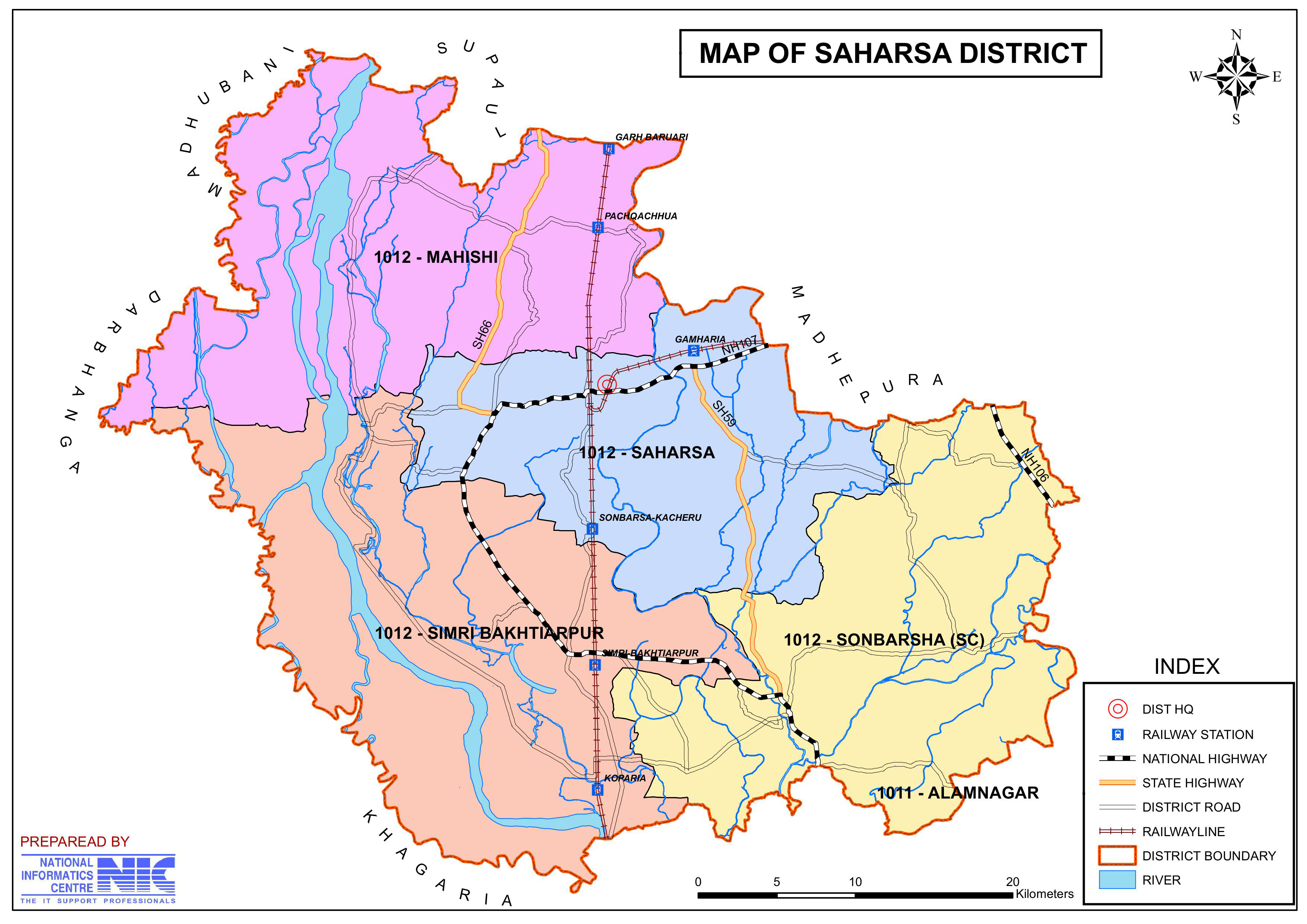
On April 30, 1981, authorities divided Saharsa district into two new districts: Madhepura and Supaul, in 1991. Saharsa district presently has two subdivisions: Saharsa Sadar and Simri Bakhtiarpur. There are ten development blocks and anchals in the district.
Key Facts About Kosi District
- Country:
 India
India - State:
 Bihar
Bihar - Region: Mithila
- Division: Kosi
- Established: 1 April 1954
- Coordinates: 25°53′N 86°36′E
- Area: 1,702 km2 (657 sq mi)
- District Headquarters: Saharsa
- Population (2011):
- Total: 1,900,661
- Density: 1,100/km2 (2,900/sq mi)
- Literacy Rate: 54.57%
- Sex Ratio: 906
- Gram Panchayats: 135
- Villages: 445 (approx)
- No. of Subdivision: 2 (Saharsa, Simri Bakhtiyarpur)
- No. of Blocks: 10
- Saharsa- Nauhatta, Sattar, Kataiya, Mahishi, Kahara, Sour Bazar, Patarghat, Sonbarsa.
- Simri-Bakhtiyarpur- Simri-Bakhtiyarpur, Salkhua, Banma Itahri.
- Police Station: 35
- Municipal Council (Nagar Parishad): 1 (Saharsa)
- Nagar Panchayat: 1 (Simri Bakhtiyarpur)
- Rivers: Koshi
- Lok Sabha constituency: 1 (Madhepura)
- Vidhan Sabha constituencies: 4 (Sonbarsha, Saharsa, Simri Bakhtiarpur, Mahishi)
- Key Features:
- A major agricultural district, producing paddy, wheat, and maize.
- Known for its connection to Mithila culture and Maithili language.
- Saharsa is a hub for education and administration in the region.
- Significance: Acts as the division’s administrative and economic center.
- Time Zone: UTC+05:30 (IST)
- Major Highways: NH-107, NH-231, NH-327
- Official Website: saharsa.nic.in
Geography
- Location: Saharsa lies in northeastern Bihar, bordered by Supaul to the north, Madhepura to the east, Khagaria to the south, and Darbhanga to the west.
- Area: The district spans an area of approximately 1,696 square kilometers.
- Rivers: The Kosi River, often referred to as the “Sorrow of Bihar” due to its frequent flooding, dominates the district and significantly impacts the region’s economy and lifestyle. Kosi river has an abundance of fish and Makhana.
- Climate: Saharsa experiences a humid subtropical climate with hot summers, heavy monsoon rains, and mild winters.
History
- Ancient Era: The region has historical links to the ancient Mithila kingdom and finds mention in historical texts as part of the Mithila region. The development of Maithili culture and literature is associated with it.
- Modern History: In 1954, the government carved out Saharsa as a separate district from Bhagalpur. Over the decades, it has evolved as a center for agriculture and trade.
Demographics
- Coordinates:
- Latitude: 25°35′ to 26°28′ North
- Longitude: 86°18′ to 86°51′ East
- Population: As per the 2011 Census, Saharsa has a population of approximately 1.90 million.
- Male: 997,174
- Female: 903,487
- Urban population: 8.24% of the total population lives in urban areas.
- Population Density: 1,125 inhabitants per square kilometer (2,910/sq mi).
- Growth Rate (2001–2011): 25.79% growth over the decade.
- Rank: 247th district in India out of 640 districts.
- Literacy Rate: The district’s literacy rate is 54.57%, with significant room for improvement in educational access, especially in rural areas.
- Sex Ratio: 906 females for every 1,000 males.
- Religious Composition (2011 Census):
- Hinduism: 85.72% of the population.
- Scheduled Castes: 16.69% of the population.
- Scheduled Tribes: 0.32% of the population.
- Islam: 14.03% of the population.
- Other/Not Stated: 0.25% of the population.
- Hinduism: 85.72% of the population.
- Languages: Maithili is the primary language spoken, alongside Hindi and regional dialects.
- Maithili: 68.87% (most widely spoken).
- Hindi: 21.15%.
- Urdu: 9.62%.
- Others: 0.36%.
Administration
- Headquarters: Saharsa town serves as the district headquarters.
- Subdivisions:
- The district is divided into two subdivisions: Saharsa Sadar and Simri Bakhtiyarpur, which are further divided into blocks for administrative purposes.
- Each subdivision is led by a subdivisional magistrate who is in charge of development, revenue-related tasks, and maintaining law and order.
- Blocks and Circles:
- Saharsa district is divided into 10 Blocks and Circles such as Kahara, Sattar Kataiya, Nauhatta, Mahishi, Sonbarsa, Sour Bazar, Patarghat, Simri Bakhtiyarpur, Salkhua and Banma Itahri.
- A circle officer (CO) leads each circle, while a Block Development Officer (BDO) leads each block.
- Governance: Saharsa falls under the Kosi division and is represented in the Bihar Legislative Assembly and Parliament.
Economy
- Agriculture: The district’s economy is predominantly agrarian, with rice, wheat, maize, and pulses being the major crops. The fertile soil and water from the Kosi River support high agricultural productivity.
- Makhana, rice, mangoes, litchi, bamboo, mustard, corn, wheat, ber, and sugarcane are among the crops farmed in the area. Nowadays, Tectona grandis or sagwan trees are cultivated extensively.
- It is the primary producer of India’s highest-quality makhana and corn. Corn and makhana are exported from Saharsa to countries including America, France, Japan, and England. Two lakh tons of corn are exported annually to other nations, including Makhana.
- Fisheries and Dairy: The district has a growing dairy and fisheries sector, contributing to the livelihoods of many local residents.
- Along with this corn product, Saharsa’s other popular businesses that employ hundreds of people are the manufacturing of jute, soap, chocolate, biscuits, and paper as well as printing.
- One of Saharsa’s key industries is brick manufacturing, which is regarded as one of the biggest brick-producing hubs in the whole Kosi area.
- Trade: Saharsa serves as a regional trading hub, especially for agricultural produce.
- With a high literacy rate, many individuals, particularly the youth, are pursuing corporate careers or starting their own businesses. Shopkeepers and dealers make major contributions to the Saharsa region’s economy.
- Challenges: Frequent flooding by the Kosi River severely affects agricultural output and infrastructure, posing a constant challenge to economic stability.
Education
Saharsa has a mix of government and private educational institutions catering to the local population. Notable institutions include:
- B.N. Mandal University (nearby in Madhepura): Serves as an important educational center for the region.
- Government Polytechnic College, Saharsa: Focuses on technical education.
- Various Schools and Colleges: Efforts are being made to improve the educational infrastructure, especially in rural areas.
Culture
- Festivals: The district celebrates festivals like Chhath Puja, Durga Puja, Sama Chakeva, and Makar Sankranti with great enthusiasm, reflecting the rich Mithila culture.
- Cuisine: Saharsa is known for Maithili cuisine, including dishes like litti chokha, pua, ghughni, and sweets like balushahi and tilkut.
- Art and Music: Traditional Maithili music and folk dances, including Jhijhiya and Nachari, are an integral part of the district’s cultural identity.
Tourism
Saharsa has limited but notable tourist attractions, primarily linked to its religious and natural significance:
- Kosi River: Though known for its destructive floods, the river’s scenic beauty and its role in agriculture make it a key geographical feature.
- Nearby Destinations: Saharsa serves as a base for exploring nearby tourist spots like Supaul, Madhepura, and Bhagalpur.
- Major Saharsa sites that draw tourists from all over the nation include Tara Sthan in Mahishi, Mandan Bharti Asthan in Mahishi, Sun Temple in Kandaha, Laxminath Gosaisthal in Bangoan, Dewan Ban Mandir in Nauhatta, Karu Khirhari temple, and many more.
- Shri Ugra Tarasthan:
- Located in Mahishi hamlet, approximately 17 kilometers west of Saharsa station, lies the Shri Ugratara Mandir, Mahishi, Saharsa.
- The statue of Bhagwati Tara in this historic temple is reputed to be very old and attracts worshippers from all over.
- The populace worships two minor female deities, Ekjata and Nil Saraswati, on either side of the main deity.
- Mandan Bharti Dham:
- Philosophical Heritage: The dham is associated with Pandit Mandan Mishra, a renowned Indian philosopher of Mimansa, and a student of the Mimansa scholar Kumarila Bhatta.
- Historical Anecdote:
- When Adi Shankaracharya sought the residence of Pandit Mandan Mishra, a pitcher-woman directed him to the scholar’s abode with a poetic description, showcasing the deep intellectual and cultural environment of the place. The poetic description are “Where parrots and mynahs are deliberating in chaste Sanskrit whether Vedas are eternal or have to be proven with the help of other scriptures and disciples are singing the hymns, is the abode of Mandan Mishra”.
- Approximately twelve hundred years ago, the two great figures of Indian philosophy met at this sacred site in Mahishi, Saharsa district. The renowned Shankaracharya and the local outstanding Mimansa scholar Mandan Mishra are reported to have engaged in a religious conversation (Shastrarth). The discourse’s judge was Bharti, the wife of Mandan Mishra, a distinguished scholar.
- Sun Temple:
- It is situated in Pastwar Panchayat of Mahishi Block, which is nearly 16kms west from Saharsa district headquarter and It is situated around 3 km north of Gorho Ghat Chowk on the route to Tarasthan, Mahishi.
- Similar to Surya Mandir in the Dev of Aurangabad district, it is a significant religious and historical site that has been formally acknowledged by the Archaeological Survey of India.
- Here at Kandaha, a single granite block has been carved with the majestic idol of Surya Bhagwan riding a seven-horse chariot. Historians have translated inscriptions above the door of the sanctum sanctorum (garbh grih), which attest to the fact that this sun temple was constructed during the 14th-century Karnata dynasty reign over Mithila under King Narsimha Deo.
- The temple was reportedly destroyed by Kalapahad, a cruel Mughal ruler; nonetheless, it was restored by the well-known saint poet Laxminath Gosai.
- Sant Karu Khirhari temple, Mahishi:
- The temple of Saint Karu Khirhari, who is said to have become divine via his Shiv-Bhakti devotion to cows, is located on the Kosi River’s bank. Karu Baba receives milk offerings from people from all walks of life.
- Despite being located on the eastern Koshi Embankment’s riverbank, this temple is close to Mahpura village, two kilometers from the Mahishi block office. Despite the raging river’s fury, it has managed to live. The Bihar government has declared its intention to make the Karu Khirhari shrine a popular tourism destination.
- Chandi temple:
- It is located in Biratpur village, which lies under the Sonebarsa block of this district. It is famous for an ancient temple of goddess Chandi. This place is also linked to King Birat of the Mahabharat era. The Pandavas had resided here for 12 years while in exile.
- The tantric Scholars and devotees attach much significance to this Chandi temple, which is said to form an equilateral triangle (TRIK) with the Tara temple at Mahishi and the Katyayani temple at Dhamara Ghat. People travel from far and wide to the village to worship to the goddess of power during Navaratri.
- Babaji Kuti, Bangaon:
- The renowned Babaji Kuti is located around 9 kilometers west of the Saharsa district headquarters. People of all sects and religions hold the enormous bunyan tree, beneath which the bones of Laxminath Gosaiji have been kept, in the highest regard.
- Dewan Ban Mandir:
- A temple in Sahpur-Manjhoul of Nauhatta block has established one Shiv Ling.
- Maharaja Shalivahan is said to have established the Ling some time in 100 BC. In honor of Jimutbahan, the son of Maharaja Shalivahan, the Hindus celebrate a festival known as Jitiya. The Shri Puran contains a description of this location.
- The violent Koshi River wiped destroyed the old temple at Dewan Ban. However, another temple has been constructed nearby by the locals.
- Nauhatta:
- It is an old village, significant since the Mughal era and currently serves as the headquarters for the block bearing the same name. There is an 80-foot-tall “Shiva temple” in the settlement. Raja Srinand Singh of Srinagar Estate rebuilt the temple after it was destroyed in the 1934 earthquake.
- Madho Singh’s burial is situated atop an earthen mound that is around 50 feet high. Madho Singh had lost his life in the Ladri Ghat combat. Both Muslims and Hindus make offerings on the occasion.
- Durga Mandir, Okahi:
- The settlement is located in the block of Sattar Kataiya. During excavation, an old image of the goddess Durga was found within. One Sone Lala Jha is said to have dreamed that he had been given supernatural instructions to dig a certain hole. The image was discovered there and later placed in the temple.
- This place is packed with devotees from all over. Every year on the day of Maha Ashtami Puja, there is a fair.
- Rakta Kali temple, Matsyagandha:
- The desolate, waterlogged territory of Saharsa town has been transformed into the lovely Matsyagandha Mandir.
- Devotees from far locations are drawn to the Rakta Kali temple and an oval temple with 64 deities (known as 64-Yogini) etched on the inside walls. Here, the Bihar government has built a stunning tourism complex.
- Shri Ugra Tarasthan:
Transportation
- Railways: Saharsa Junction is an important railway hub in the region, connecting the district to major cities like Patna, Delhi, and Kolkata.
- Roadways: National Highways and State Highways connect the district, and bus services facilitate transport to nearby regions.
- Nearest Airport: The nearest airport is Darbhanga Airport (approximately 120 km), providing domestic connectivity.
Challenges
- Flooding: The Kosi River’s frequent flooding remains the most significant challenge, causing loss of life, property, and agricultural output.
- Infrastructure: Limited infrastructure development, especially in healthcare and education, hampers overall growth.
- Unemployment: A lack of industrialization forces many residents to migrate to other states for work.
Conclusion
Saharsa is a district of contrasts, with its rich cultural heritage and fertile lands juxtaposed against the challenges posed by the Kosi River. Despite the hurdles, the district holds promise, with efforts focused on improving infrastructure, education, and disaster management. Saharsa remains an integral part of Bihar’s economy and cultural identity, symbolizing the resilience and spirit of the Mithila region.
Would you like more details about any specific Topics on Bihar? Comment Below or checkout these topics
सहरसा जिला: विशेष विरासत और सौंदर्य का अनावरण
अवलोकन
सहरसा, भारत के बिहार के कोसी डिवीजन में स्थित 38वें जिलों में से एक है, जो अपनी उपजाऊ कृषि भूमि, सांस्कृतिक विरासत और विशाल कोसी नदी द्वारा उत्पन्न चुनौतियों के लिए जाना जाता है। इसे 1 अप्रैल 1954 को एक जिले के रूप में स्थापित किया गया था। जिले का प्रशासनिक मुख्यालय सहरसा शहर में स्थित है। सहरसा जिला मिथिला क्षेत्र में स्थित है, जो ब्राह्मणवादी सभ्यता के लिए भारत के पहले केंद्रों में से एक है। कहा जाता है कि पूरा मिथिला क्षेत्र सहरसा के आसपास केंद्रित है। यह मंदाना मिश्रा, लक्ष्मीनाथ गोसाईं और उभय भारती जैसे दिग्गजों की जन्मस्थली है। यह बिहार में ऐतिहासिक और आर्थिक महत्व रखता है और मिथिला क्षेत्र के प्रवेश द्वार के रूप में कार्य करता है।
इंडो-आर्यन लोगों द्वारा उपनिवेश बनाए जाने के बाद, जिन्होंने मिथिला साम्राज्य (जिसे विदेहों के साम्राज्य के रूप में भी जाना जाता है) की स्थापना की, कुरु और पंचाल के साथ, विदेह उत्तर वैदिक युग (लगभग 1100-500 ईसा पूर्व) के दौरान दक्षिण एशिया के प्रमुख राजनीतिक और सांस्कृतिक केंद्रों में से एक के रूप में उभरा। विदेह साम्राज्य के शासकों को जनक कहा जाता था। वैशाली शहर, जो मिथिला में स्थित है, वज्जिका लीग की राजधानी के रूप में कार्य करता था, जिसमें बाद में विदेह साम्राज्य शामिल हो गया।
मंडन मिश्र, जिनका शंकराचार्य के साथ प्रवचन दुनिया के सबसे बुद्धिमान लोगों में से एक माना जाता है, महिष्मती गांव में हुआ था, जिसे आज महिषी गांव के रूप में जाना जाता है। आदि शंकराचार्य की धर्म विजय यात्रा के दौरान, उन्होंने मंडन मिश्र से विवाद करने के लिए महिषी गांव (जिसे पहले महिष्मती के नाम से जाना जाता था) का दौरा किया। देश भर में सभी तर्क जीतने के बाद, उन्होंने वहां शास्त्रार्थ खो दिया।
पहले, सहरसा जिला मुंगेर और भागलपुर जिलों का हिस्सा था। 1 अप्रैल 1954 को इसे एक अलग जिले के रूप में स्थापित किया गया था। 2 अक्टूबर 1972 को इसे कोसी प्रमंडल का मुख्यालय भी नामित किया गया, जिसमें सहरसा, पूर्णिया और कटिहार जिले शामिल थे और इसका मुख्यालय सहरसा में था। इसी तरह, 1 दिसंबर 1972 को एक नया सिविल सब-डिवीजन बीरपुर की स्थापना की गई, जिसमें राघोपुर, छातापुर, बसंतपुर और निर्मली सहित 24 विकास खंड शामिल थे, जो पहले जिले के सुपौल अनुमंडल का हिस्सा थे। सहरसा जिले को क्रमशः 30 अप्रैल 1981 और 1991 को दो नए जिलों, मधेपुरा और सुपौल में विभाजित किया गया था। सहरसा जिले में वर्तमान में दो अनुमंडल हैं: सहरसा सदर और सिमरी बख्तियारपुर। जिले में दस विकास खंड और अंचल हैं।
कोसी जिले के बारे में मुख्य तथ्य
- देश: भारत
- राज्य: बिहार
- क्षेत्र: मिथिला
- प्रमंडल: कोसी
- स्थापना: 1 अप्रैल 1954
- निर्देशांक: 25°53′N 86°36′E
- क्षेत्रफल: 1,702 km2 (657 वर्ग मील)
- जिला मुख्यालय: सहरसा
- जनसंख्या (2011):
- कुल: 1,900,661
- घनत्व: 1,100/ km2 (2,900/वर्ग मील)
- साक्षरता दर: 54.57%
- लिंगानुपात: 906
- ग्राम पंचायतें: 135
- गाँव: 445 (लगभग)
- अनुमंडल की संख्या: 2 (सहरसा, सिमरी बख्तियारपुर)
- ब्लॉकों की संख्या: 10
- सहरसा- नौहट्टा, सत्तर, कटैया, महिषी, कहरा, सौर बाजार, पतरघट, सोनबरसा।
- सिमरी-बख्तियारपुर- सिमरी-बख्तियारपुर, सलखुआ, बनमा इटाहरी.
- पुलिस स्टेशन: 35
- नगर परिषद: 1 (सहरसा)
- नगर पंचायत: 1 (सिमरी बख्तियारपुर)
- नदियाँ: कोशी
- लोकसभा क्षेत्र: 1 (मधेपुरा)
- विधान सभा क्षेत्र: 4 (सोनबर्षा, सहरसा, सिमरी बख्तियारपुर, महिषी)
- प्रमुख विशेषताऐं:
- धान, गेहूं और मक्का का उत्पादन करने वाला एक प्रमुख कृषि जिला।
- मिथिला संस्कृति और मैथिली भाषा से जुड़ाव के लिए जाना जाता है।
- सहरसा क्षेत्र में शिक्षा और प्रशासन का केंद्र है।
- महत्व: प्रभाग के प्रशासनिक और आर्थिक केंद्र के रूप में कार्य करता है।
- समय क्षेत्र: UTC+05:30 (IST)
- प्रमुख राजमार्ग: NH-107, NH-231, NH-327
- आधिकारिक वेबसाइट: saharsa.nic.in
भूगोल
- स्थान: सहरसा उत्तर-पूर्वी बिहार में स्थित है, जिसकी सीमा उत्तर में सुपौल, पूर्व में मधेपुरा, दक्षिण में खगड़िया और पश्चिम में दरभंगा से लगती है।
- क्षेत्र: यह जिला लगभग 1,696 वर्ग किलोमीटर में फैला हुआ है।
- नदियाँ: इस जिले में कोसी नदी का प्रभुत्व है, जिसे अक्सर “बिहार का शोक” कहा जाता है, क्योंकि इसमें अक्सर बाढ़ आती है, जो इस क्षेत्र की अर्थव्यवस्था और जीवनशैली को महत्वपूर्ण रूप से प्रभावित करती है। कोसी नदी में मछली और मखाना प्रचुर मात्रा में हैं।
- जलवायु: सहरसा में गर्म ग्रीष्मकाल, भारी मानसूनी बारिश और हल्की सर्दियाँ के साथ आर्द्र उपोष्णकटिबंधीय जलवायु होती है।
इतिहास
- प्राचीन युग: इस क्षेत्र का प्राचीन मिथिला साम्राज्य से ऐतिहासिक संबंध है और ऐतिहासिक ग्रंथों में मिथिला क्षेत्र के हिस्से के रूप में इसका उल्लेख मिलता है। यह मैथिली संस्कृति और साहित्य के विकास से जुड़ा हुआ है।
- आधुनिक इतिहास: सहरसा को 1954 में भागलपुर से अलग करके एक अलग जिले के रूप में बनाया गया था। दशकों से, यह कृषि और व्यापार के केंद्र के रूप में विकसित हुआ है।
जनसांख्यिकी
- निर्देशांक:
- अक्षांश: 25°35′ से 26°28′ उत्तर
- देशांतर: 86°18′ से 86°51′ पूर्व
- जनसंख्या: 2011 की जनगणना के अनुसार, सहरसा की जनसंख्या लगभग 1.90 मिलियन है।
- पुरुष: 997,174
- महिला: 903,487
- शहरी जनसंख्या: कुल जनसंख्या का 8.24% शहरी क्षेत्रों में रहता है।
- जनसंख्या घनत्व: 1,125 निवासी प्रति वर्ग किलोमीटर (2,910/वर्ग मील)।
- विकास दर (2001–2011): दशक में 25.79% की वृद्धि।
- रैंक: भारत के 640 जिलों में से 247वाँ जिला।
- साक्षरता दर: जिले की साक्षरता दर 54.57% है, जिसमें शिक्षा तक पहुँच में सुधार की काफी गुंजाइश है, खासकर ग्रामीण क्षेत्रों में।
- लिंग अनुपात: हर 1,000 पुरुषों पर 906 महिलाएँ।
- धार्मिक संरचना (2011 की जनगणना):
- हिंदू धर्म: जनसंख्या का 85.72%
- अनुसूचित जाति: जनसंख्या का 16.69%
- अनुसूचित जनजाति: जनसंख्या का 0.32%
- इस्लाम: जनसंख्या का 14.03%
- अन्य/बताया नहीं गया: जनसंख्या का 0.25%
- हिंदू धर्म: जनसंख्या का 85.72%
- भाषाएँ: मैथिली हिंदी और क्षेत्रीय बोलियों के साथ-साथ बोली जाने वाली मुख्य भाषा है।
- मैथिली: 68.87% (सबसे अधिक बोली जाने वाली)
- हिंदी: 21.15%
- उर्दू: 9.62%
- अन्य: 0.36%
प्रशासन
- मुख्यालय: सहरसा शहर जिला मुख्यालय के रूप में कार्य करता है।
- उपखंड:
- जिले को दो उपखंडों में विभाजित किया गया है: सहरसा सदर और सिमरी बख्तियारपुर, जिन्हें प्रशासनिक उद्देश्यों के लिए आगे ब्लॉकों में विभाजित किया गया है।
- एक उपखंड मजिस्ट्रेट प्रत्येक उपखंड का नेतृत्व करता है और विकास, राजस्व से संबंधित कार्यों और कानून व्यवस्था बनाए रखने का प्रभारी होता है।
- ब्लॉक और सर्किल:
- सहरसा जिले को 10 ब्लॉक और सर्किल में विभाजित किया गया है जैसे कहरा, सत्तर कटैया, नौहट्टा, महिषी, सोनबरसा, सौर बाजार, पतरघाट, सिमरी बख्तियारपुर, सलखुआ और बनमा इटहरी।
- एक सर्किल अधिकारी (सीओ) प्रत्येक सर्किल का नेतृत्व करता है, जबकि एक ब्लॉक विकास अधिकारी (बीडीओ) प्रत्येक ब्लॉक का नेतृत्व करता है।
- शासन: सहरसा कोसी प्रमंडल के अंतर्गत आता है और इसका प्रतिनिधित्व बिहार विधानसभा और संसद में होता है।
अर्थव्यवस्था
- कृषि: जिले की अर्थव्यवस्था मुख्य रूप से कृषि आधारित है, जिसमें चावल, गेहूं, मक्का और दालें प्रमुख फसलें हैं। कोसी नदी से उपजाऊ मिट्टी और पानी उच्च कृषि उत्पादकता का समर्थन करते हैं।
- मखाना, चावल, आम, लीची, बांस, सरसों, मक्का, गेहूं, बेर और गन्ना क्षेत्र में उगाई जाने वाली फसलों में से हैं। आजकल, टेक्टोना ग्रैंडिस या सागवान के पेड़ों की बड़े पैमाने पर खेती की जाती है।
- यह भारत के उच्चतम गुणवत्ता वाले मखाना और मकई का प्राथमिक उत्पादक है। सहरसा से मक्का और मखाना अमेरिका, फ्रांस, जापान और इंग्लैंड सहित देशों में निर्यात किया जाता है। मखाना सहित अन्य देशों को सालाना दो लाख टन मक्का निर्यात किया जाता है।
- मत्स्य पालन और डेयरी: जिले में डेयरी और मत्स्य पालन क्षेत्र बढ़ रहा है, जो कई स्थानीय निवासियों की आजीविका में योगदान देता है।
- इस मकई उत्पाद के साथ, सहरसा के अन्य लोकप्रिय व्यवसाय जो सैकड़ों लोगों को रोजगार देते हैं, वे हैं जूट, साबुन, चॉकलेट, बिस्कुट और कागज के साथ-साथ छपाई का निर्माण।
- सहरसा के प्रमुख उद्योगों में से एक ईंट निर्माण है, जिसे पूरे कोसी क्षेत्र में सबसे बड़े ईंट-उत्पादन केंद्रों में से एक माना जाता है।
- व्यापार: सहरसा एक क्षेत्रीय व्यापार केंद्र के रूप में कार्य करता है, खासकर कृषि उपज के लिए।
- उच्च साक्षरता दर के साथ, कई व्यक्ति, विशेष रूप से युवा, कॉर्पोरेट करियर बना रहे हैं या अपना खुद का व्यवसाय शुरू कर रहे हैं। दुकानदार और डीलर सहरसा क्षेत्र की अर्थव्यवस्था में प्रमुख योगदान देते हैं।
- चुनौतियाँ: कोसी नदी में बार-बार आने वाली बाढ़ से कृषि उत्पादन और बुनियादी ढाँचा बुरी तरह प्रभावित होता है, जिससे आर्थिक स्थिरता के लिए लगातार चुनौती बनी रहती है।
शिक्षा
सहरसा में स्थानीय आबादी की ज़रूरतों को पूरा करने वाले सरकारी और निजी शैक्षणिक संस्थानों का मिश्रण है। उल्लेखनीय संस्थानों में शामिल हैं:
- बी.एन. मंडल विश्वविद्यालय (मधेपुरा में पास में): इस क्षेत्र के लिए एक महत्वपूर्ण शैक्षणिक केंद्र के रूप में कार्य करता है।
- सरकारी पॉलिटेक्निक कॉलेज, सहरसा: तकनीकी शिक्षा पर ध्यान केंद्रित करता है।
- विभिन्न स्कूल और कॉलेज: विशेष रूप से ग्रामीण क्षेत्रों में शैक्षिक बुनियादी ढांचे को बेहतर बनाने के प्रयास किए जा रहे हैं।
संस्कृति
- त्यौहार: जिले में छठ पूजा, दुर्गा पूजा, सामा चकेवा और मकर संक्रांति जैसे त्यौहार बहुत उत्साह के साथ मनाए जाते हैं, जो समृद्ध मिथिला संस्कृति को दर्शाते हैं।
- भोजन: सहरसा मैथिली व्यंजनों के लिए जाना जाता है, जिसमें लिट्टी चोखा, पुआ, घुघनी जैसे व्यंजन और बालूशाही और तिलकुट जैसी मिठाइयाँ शामिल हैं।
- कला और संगीत: झिझिया और नचारी सहित पारंपरिक मैथिली संगीत और लोक नृत्य, जिले की सांस्कृतिक पहचान का एक अभिन्न अंग हैं।
पर्यटन
सहरसा में सीमित लेकिन उल्लेखनीय पर्यटक आकर्षण हैं, जो मुख्य रूप से इसके धार्मिक और प्राकृतिक महत्व से जुड़े हैं:
- कोसी नदी: हालांकि यह अपनी विनाशकारी बाढ़ के लिए जानी जाती है, लेकिन नदी की प्राकृतिक सुंदरता और कृषि में इसकी भूमिका इसे एक प्रमुख भौगोलिक विशेषता बनाती है।
- आस-पास के गंतव्य: सहरसा सुपौल, मधेपुरा और भागलपुर जैसे आस-पास के पर्यटन स्थलों की खोज के लिए एक आधार के रूप में कार्य करता है।
- देश भर से पर्यटकों को आकर्षित करने वाले प्रमुख सहरसा स्थलों में महिषी में तारा स्थान, महिषी में मंडन भारती अस्थान, कंदाहा में सूर्य मंदिर, बंगाओन में लक्ष्मीनाथ गोसाईस्थल, नौहट्टा में दीवान बन मंदिर, कारू खिरहरि मंदिर और कई अन्य शामिल हैं।
- श्री उग्र तारास्थान:
- सहरसा स्टेशन से लगभग 17 किलोमीटर पश्चिम में महिषी गांव में स्थित श्री उग्रतारा मंदिर, महिषी, सहरसा स्थित है।
- इस ऐतिहासिक मंदिर में भगवती तारा की प्रतिमा बहुत पुरानी मानी जाती है और यह हर जगह से भक्तों को आकर्षित करती है।
- लोग मुख्य देवता के दोनों ओर दो छोटी महिला देवताओं, एकजटा और नील सरस्वती की पूजा करते हैं।
- मंडन भारती धाम:
- दार्शनिक विरासत: यह धाम मीमांसा के प्रसिद्ध भारतीय दार्शनिक पंडित मंडन मिश्र से जुड़ा है, और मीमांसा विद्वान कुमारिल भट्ट के छात्र थे।
- ऐतिहासिक किस्सा:
- जब आदि शंकराचार्य पंडित मंडन मिश्र के निवास की तलाश में थे, तो एक घड़ा-महिला ने उन्हें एक काव्यात्मक वर्णन के साथ विद्वान के निवास की ओर निर्देशित किया, जो उस स्थान के गहन बौद्धिक और सांस्कृतिक वातावरण को दर्शाता है। काव्यात्मक वर्णन है “जहाँ तोते और मैनाएँ शुद्ध संस्कृत में विचार-विमर्श कर रहे हैं कि वेद शाश्वत हैं या अन्य शास्त्रों की सहायता से सिद्ध किए जाने चाहिए और शिष्य भजन गा रहे हैं, वह मंडन मिश्र का निवास स्थान है”।
- लगभग बारह सौ साल पहले, भारतीय दर्शन के दो महान व्यक्ति महिषी, सहरसा जिले में इस पवित्र स्थल पर मिले थे। प्रसिद्ध शंकराचार्य और स्थानीय उत्कृष्ट मीमांसा विद्वान मंडन मिश्र के बीच धार्मिक वार्तालाप (शास्त्रार्थ) हुआ था। प्रवचन की निर्णायक मंडन मिश्र की पत्नी भारती थीं, जो एक प्रतिष्ठित विद्वान थे।
- सूर्य मंदिर:
- यह महिषी प्रखंड के पस्तवार पंचायत में स्थित है, जो सहरसा जिला मुख्यालय से लगभग 16 किलोमीटर पश्चिम में है और यह गोरहो घाट चौक से लगभग 3 किलोमीटर उत्तर में तारास्थान, महिषी के मार्ग पर स्थित है।
- औरंगाबाद जिले के देव में सूर्य मंदिर के समान, यह एक महत्वपूर्ण धार्मिक और ऐतिहासिक स्थल है जिसे औपचारिक रूप से भारतीय पुरातत्व सर्वेक्षण द्वारा मान्यता दी गई है।
- यहाँ कंदाहा में, एक ग्रेनाइट ब्लॉक पर सात घोड़ों के रथ पर सवार सूर्य भगवान की राजसी मूर्ति उकेरी गई है। इतिहासकारों ने गर्भगृह के द्वार के ऊपर शिलालेखों का अनुवाद किया है, जो इस तथ्य की पुष्टि करते हैं कि इस सूर्य मंदिर का निर्माण 14वीं शताब्दी में राजा नरसिंह देव के अधीन मिथिला पर कर्नाटक राजवंश के शासनकाल के दौरान किया गया था।
- कथित तौर पर मंदिर को क्रूर मुगल शासक कालापहाड़ ने नष्ट कर दिया था; फिर भी, इसे प्रसिद्ध संत कवि लक्ष्मीनाथ गोसाई ने बहाल किया था।
- संत कारू खिरहरि मंदिर, महिषी:
- संत कारू खिरहरि का मंदिर, जिनके बारे में कहा जाता है कि वे गायों के प्रति अपनी शिव-भक्ति भक्ति के कारण दिव्य बन गए थे, कोसी नदी के तट पर स्थित है। कारू बाबा को सभी वर्गों के लोग दूध का प्रसाद चढ़ाते हैं।
- पूर्वी कोशी तटबंध के नदी तट पर स्थित होने के बावजूद, यह मंदिर महिषी ब्लॉक कार्यालय से दो किलोमीटर दूर महपुरा गाँव के करीब है। नदी के प्रचंड प्रकोप के बावजूद यह जीवित रहने में कामयाब रही है। बिहार सरकार ने कारू खिरहरि तीर्थ को एक लोकप्रिय पर्यटन स्थल बनाने का इरादा जताया है।
- चंडी मंदिर:
- यह इस जिले के सोनबरसा प्रखंड के अंतर्गत बीरटपुर गांव में स्थित है। यह देवी चंडी के एक प्राचीन मंदिर के लिए प्रसिद्ध है। महाभारत काल के राजा बीरट का भी इस स्थान से संबंध है। पांडवों ने वनवास के दौरान 12 वर्षों तक यहां निवास किया था।
- तांत्रिक विद्वान और भक्त इस चंडी मंदिर को बहुत महत्व देते हैं, जिसके बारे में कहा जाता है कि यह महिषी में तारा मंदिर और धमारा घाट में कात्यायनी मंदिर के साथ एक समबाहु त्रिभुज (त्रिक) बनाता है। नवरात्रि के दौरान शक्ति की देवी की पूजा करने के लिए लोग दूर-दूर से गांव आते हैं।
- बाबाजी कुटी, बनगांव:
- प्रसिद्ध बाबाजी कुटी सहरसा जिला मुख्यालय से लगभग 9 किलोमीटर पश्चिम में स्थित है। सभी संप्रदायों और धर्मों के लोग उस विशाल बरगद के पेड़ को सर्वोच्च सम्मान देते हैं, जिसके नीचे लक्ष्मीनाथ गोसाईजी की अस्थियाँ रखी गई हैं।
- दीवान बन मंदिर:
- नौहट्टा ब्लॉक के साहपुर-मंझौल में स्थित मंदिर में एक शिव लिंग स्थापित है।
- ऐसा कहा जाता है कि लिंग की स्थापना महाराजा शालिवाहन ने 100 ईसा पूर्व में की थी। महाराजा शालिवाहन के पुत्र जीमूतबहन के सम्मान में, हिंदू जितिया नामक त्यौहार मनाते हैं। श्री पुराण में इस स्थान का वर्णन है।
- हिंसक कोशी नदी ने दीवान बन में पुराने मंदिर को नष्ट कर दिया। हालाँकि, स्थानीय लोगों द्वारा पास में एक और मंदिर बनाया गया है।
- नौहट्टा:
- यह एक पुराना गाँव है, जो मुगल काल से ही महत्वपूर्ण है और वर्तमान में इसी नाम वाले ब्लॉक का मुख्यालय है। बस्ती में एक 80 फुट ऊँचा “शिव मंदिर” है। श्रीनगर एस्टेट के राजा श्रीनंद सिंह ने 1934 के भूकंप में नष्ट हो जाने के बाद मंदिर का पुनर्निर्माण करवाया।
- माधो सिंह की समाधि एक मिट्टी के टीले के ऊपर स्थित है जो लगभग 50 फीट ऊंचा है। माधो सिंह ने लाद्री घाट युद्ध में अपनी जान गंवा दी थी। इस अवसर पर मुस्लिम और हिंदू दोनों ही प्रसाद चढ़ाते हैं।
- दुर्गा मंदिर, ओकाही:
- यह बस्ती सत्तर कटैया के ब्लॉक में स्थित है। खुदाई के दौरान, देवी दुर्गा की एक पुरानी प्रतिमा मिली थी। कहा जाता है कि सोने लाला झा नामक व्यक्ति ने सपना देखा था कि उसे एक निश्चित गड्ढा खोदने के लिए अलौकिक निर्देश दिए गए हैं। प्रतिमा वहाँ मिली और बाद में उसे मंदिर में स्थापित कर दिया गया।
- यह स्थान हर जगह से भक्तों से भरा हुआ है। हर साल महा अष्टमी पूजा के दिन यहाँ मेला लगता है।
- रक्त काली मंदिर, मत्स्यगंधा:
- सहरसा शहर का उजाड़, जलमग्न इलाका सुंदर मत्स्यगंधा मंदिर में तब्दील हो गया है।
- दूर-दूर से भक्त रक्त काली मंदिर और एक अंडाकार मंदिर की ओर आकर्षित होते हैं, जिसकी अंदर की दीवारों पर 64 देवी-देवता (जिन्हें 64-योगिनी के रूप में जाना जाता है) उकेरे गए हैं। यहाँ, बिहार सरकार ने एक शानदार पर्यटन परिसर बनाया है।
- श्री उग्र तारास्थान:
परिवहन
- रेलवे: सहरसा जंक्शन इस क्षेत्र का एक महत्वपूर्ण रेलवे हब है, जो जिले को पटना, दिल्ली और कोलकाता जैसे प्रमुख शहरों से जोड़ता है।
- सड़क मार्ग: जिला राष्ट्रीय राजमार्गों और राज्य राजमार्गों से जुड़ा हुआ है, बस सेवाएं आस-पास के क्षेत्रों में परिवहन की सुविधा प्रदान करती हैं।
- निकटतम हवाई अड्डा: निकटतम हवाई अड्डा दरभंगा हवाई अड्डा (लगभग 120 किमी) है, जो घरेलू संपर्क प्रदान करता है।
चुनौतियाँ
- बाढ़: कोसी नदी की लगातार बाढ़ सबसे बड़ी चुनौती बनी हुई है, जिससे जान-माल और कृषि उत्पादन को नुकसान होता है।
- बुनियादी ढाँचा: सीमित बुनियादी ढाँचा विकास, विशेष रूप से स्वास्थ्य सेवा और शिक्षा में, समग्र विकास को बाधित करता है।
- बेरोज़गारी: औद्योगीकरण की कमी कई निवासियों को काम के लिए दूसरे राज्यों में पलायन करने के लिए मजबूर करती है।
निष्कर्ष
सहरसा विरोधाभासों का जिला है, इसकी समृद्ध सांस्कृतिक विरासत और उपजाऊ भूमि कोसी नदी द्वारा उत्पन्न चुनौतियों के विपरीत है। बाधाओं के बावजूद, जिले में बुनियादी ढाँचे, शिक्षा और आपदा प्रबंधन में सुधार पर ध्यान केंद्रित करने के साथ वादा है। सहरसा बिहार की अर्थव्यवस्था और सांस्कृतिक पहचान का एक अभिन्न अंग बना हुआ है, जो मिथिला क्षेत्र की लचीलापन और भावना का प्रतीक है।
क्या आप बिहार के किसी विशेष विषय के बारे में अधिक जानकारी चाहते हैं? नीचे टिप्पणी करें
पदानुक्रमिक संरचना: बिहार का विस्तृत रोडमैप
बिहार में प्रमंडल और उसके जिलों का विवरण
Important Links
𝕋𝕙𝕒𝕟𝕜 𝕐𝕠𝕦 𝔽𝕠𝕣 𝕍𝕚𝕤𝕚𝕥𝕚𝕟𝕘 𝕆𝕦𝕣 𝕎𝕖𝕓𝕤𝕚𝕥𝕖𝕤 🙂
6 thoughts on “Saharsa District: Unveiling the Special Legacy and Beauty”