
Supaul District: An Overview
Supaul, is one of the 38 districts located in the northern part of Bihar, India. The Supaul district has borders with Araria and Purnia to the east, Madhubani to the west, Nepal to the north, Saharsa and Madhepura to the south. The district covers an area of 2,410 km2 (931 sq mi) and was separated from the previous Saharsa district on March 14, 1991. It is one of the district under the Koshi division. The district’s administrative center is located at Supaul town.
It is closely tied to the Kosi River, which significantly impacts its economy, lifestyle, and challenges. The district is an essential part of the Mithila region and reflects the rich cultural richness, fertile lands and resilience of its people.
Since the late Vedic era (c. 1100–500 BCE), the District of Supaul has been a part of Mithilanchal (Mithila Region). Mithila initially gained to prominence when Indo-Aryans migrated there and founded the Mithila Kingdom, also known as the Kingdom of the Videhas. Videha, Kuru, and Pañcāla emerged as South Asia’s principal centers of culture and politics. The Videha Kingdom’s rulers were known as Janakas. Vaishali, which is located in Mithila, served as the capital of the Vajjika League, which subsequently included the Videha Kingdom.
In Hindu mythology, the region is known as the fisheries area (Matasya Kshetra). Angutaran and Apadnigam, the two earliest democracies, are renowned for having existed throughout the Buddhist era, which includes the present-day Supaul region.
Supaul is located in latitude 25° 37′-26° 25′ N and longitude 86° 22′-87° 10′ E. The kind of soil is alluvial and sandy. The Koshi River runs through the district, which is regarded as the sorrow of the whole state of Bihar, not just this particular location. Some of its tributaries include tilyuga chhaimra, kali, tilawe, bhenga, mirchaiya, and sursar. Its nature is basic in some places and acetic in others. Bihar’s Supaul district has 2,420 square kilometers in size.
Key Facts About Supaul District
- Country:
 India
India - State:
 Bihar
Bihar - Region: Mithila
- Division: Kosi
- Coordinates: 25.9300°N 86.2500°E
- Established: 14 March 1991
- Area: 2,410 km2 (930 sq mi)
- District Headquarters: Supaul
- District Magistrate (DM): Shri Kaushal Kumar, IAS
- Superintendent of Police (SP): Shri Shaishav Yadav, IPS
- Population (2011):
- Total: 2,229,076
- Density: 920/km2 (2,400/sq mi)
- Literacy Rate: 72.86%
- Sex Ratio: 925 females/1000 males
- Gram Panchayats: 181
- Villages: 556 (approx)
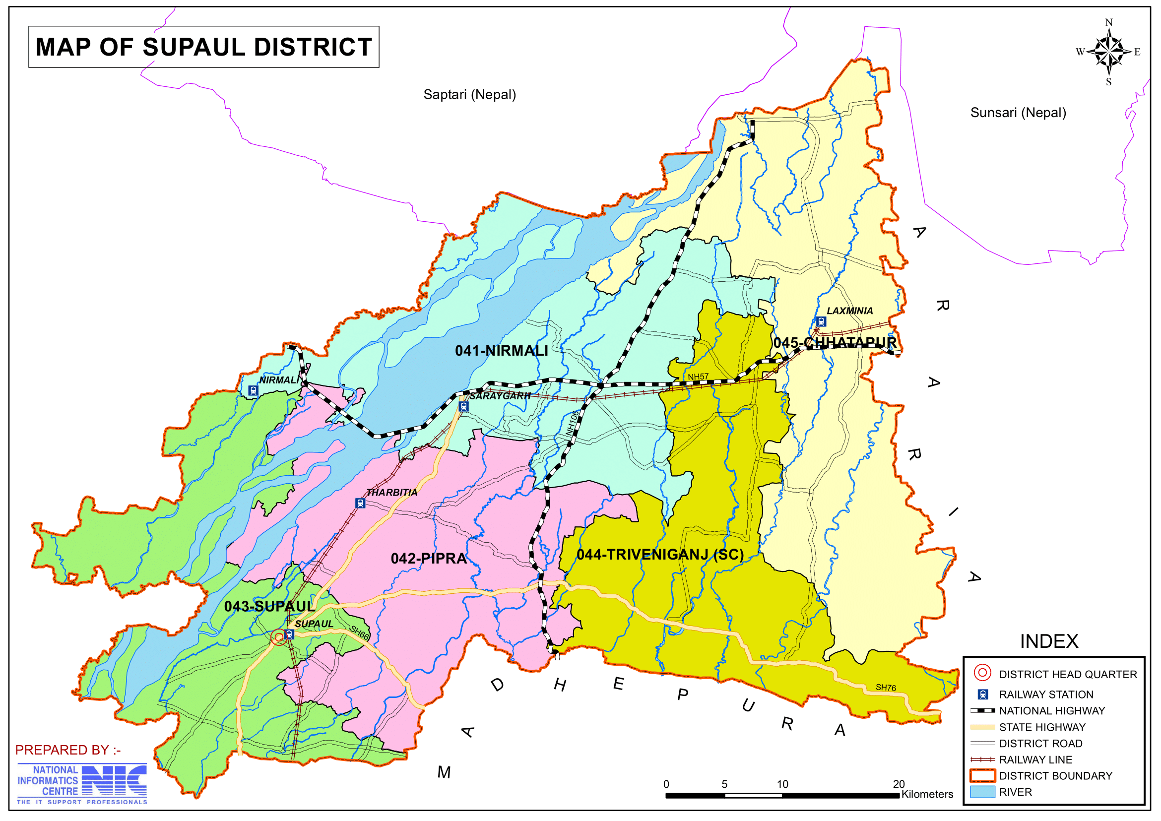
- No. of Subdivision: 4 (Supaul Sadar, Triveniganj, Birpur, Nirmali)
- No. of Blocks: 11
- Supaul Sadar- Supaul, Kishanpur, Saraigarh-Bhaptiyahi, Pipra.
- Birpur- Basantpur, Raghopur, Pratapganj.
- Triveniganj- Triveniganj, Chhatapur.
- Nirmali- Nirmali, Marauna.
- Police Station: 23
- Bhimnagar, Birpur, Karjain, Pratapganj, Raghopur, Ratanpura, Dagmara, Kunauli, Marauna, Nirmali, Riverine, Bhaptai Sarai, Kishunpur, Lokha, Pipra, Supaul, Balua Bazaar, Bhimpur, Chhatapur, Jadia, Lalitgram, Rajeswari, Triveniganj
- Municipal Council (Nagar Parishad): 1 (Supaul)
- Nagar Panchayat: 2 (Birpur, Nirmali)
- Rivers: Koshi
- Lok Sabha constituency:1 (Supaul)
- Vidhan Sabha constituencies: 5
- 41- Nirmali, 42- Pipra, 43- Supaul, 44- Triveniganj, 45- Chhatapur
- Key Features:
- A border district near Nepal, strategically important for cross-border trade.
- Fertile lands enriched by the Kosi River, supporting rice and jute production.
- Known for the Kosi Barrage, a vital irrigation and flood control project.
- Significance: A district of strategic, agricultural, and developmental importance.
- Notable People:
- Lalit Narayan Mishra: An Indian politician who served as Minister of Railways in the government of India from 1973 to 1975.
- R K Singh, IAS: A former Indian bureaucrat served as Home Secretary to Government of India and a MP since May 2014.
- Syed Shahnawaz Hussain: BJP spokesperson and former Union Minister.
- Udit Narayan: A Singer, who was born in the village of Baisi, Supaul.
- Sharda Sinha: An indian folk and classical singer is called Bihar Kokila, the cuckoo of Bihar.
- Govind Kumar Singh: a fashion designer.
- Aman Anand Singh: An Indian Entrepreneur and Founder of Arise Point (a global Online Reputation Management (ORM) Company).
- Major Highways: NH-57, NH-106, NH-107, NH-327E NH-327A, SH-91, SH-76, Indo-Nepal border road.
- Time Zone: UTC+05:30 (IST)
- STD Code: 06473
- PIN Code: 8521xx (Supaul)
- Official Website: supaul.nic.in
Geography
- Location: Supaul is situated in the northeastern part of Bihar, bordered by Nepal to the north, Araria and Purnia to the east, Saharsa and Madhepura to the south, and Madhubani to the west.
- Area: The district covers an area of approximately 2,410 square kilometers.
- Rivers: The district is dominated by the Kosi River, which, while providing fertile lands for agriculture, also causes frequent and devastating floods.
- Climate: Supaul experiences a humid subtropical climate with hot summers, heavy monsoon rains, and mild winters.
History
- Ancient Era: Supaul has historical ties to the ancient Mithila kingdom and is part of the broader Mithila region, known for its literary and cultural contributions.
- Formation: Supaul was carved out of the Saharsa district and established as a separate district on 14 March 1991.
Demographics (According to the 2011 Census)
- Population:
- Total: Supaul district has a population of 2,229,076 (approximately 2.22 million), comparable to the population of Republic of Latvia (a country in the Baltic region of Northern Europe) or the US state of New Mexico (a state in the Southwestern region of the US)
- Ranking: 204th in India (out of 640 districts).
- Population Density: 919 inhabitants per square kilometre (2,380/sq mi).
- Growth Rate (2001–2011): 28.62%, reflecting significant population increase.
- Literacy Rate: The literacy rate is around 72.86%, reflecting gradual improvement in education.
- Sex Ratio: 925 females for every 1000 males, indicating a gender disparity.
- Religious Composition (2011 Census):
- Hinduism: 81.20%
- Scheduled Castes: 15.89%
- Scheduled Tribes: 0.46%
- Islam: 18.36%
- Other or not stated: 0.44%
- Hinduism: 81.20%
- Languages: Maithili is the primary language spoken, followed by Hindi, Urdu and Bengali.
- Maithili: 76.31%
- Hindi: 12.43%
- Urdu: 9.30%
- Bengali: 1.25%
- Others: 0.71%
- Urban Population Statistics:
- Urban Population:
- Total urban population: 105,558 (4.74% of the total population).
- Males: 55,788; Females: 49,770.
- Sex Ratio:
- Overall: 892 females per 1,000 males.
- Children (0–6 years): 932 females per 1,000 males.
- Child Population:
- Total children (ages 0–6): 17,654 (16.38% of the urban population).
- Males: 9,140; Females: 8,514.
- Literacy Rate:
- Overall: 72.74%.
- Males: 80.78%; Females: 63.64%.
- Total literates: 63,939.
- Males: 37,684; Females: 26,255.
- Urban Population:
- Rural Population Statistics:
- Rural Population:
- Total rural population: 2,123,518 (95.26% of the total population).
- Males: 1,099,495; Females: 1,024,023.
- Sex Ratio:
- Overall: 931 females per 1,000 males.
- Children (0–6 years): 945 girls per 1,000 boys.
- Child Population:
- Total children (ages 0–6): 419,703 (19.63% of the rural population).
- Males: 215,813; Females: 203,890.
- Literacy Rate:
- Overall: 56.89%.
- Males: 69.03%; Females: 43.82%.
- Total literates: 969,344.
- Males: 609,988; Females: 359,356.
- Rural Population:
Administration
- Headquarters: Supaul town serves as the district headquarters.
- Subdivisions:
- The district is divided into four subdivisions: Supaul, Birpur, Triveniganj, and Nirmali, which are further divided into blocks for better administration.
- Each subdivision is led by a subdivisional magistrate who is in charge of development, revenue-related tasks, and maintaining law and order.
- Blocks and Circles:
- Supaul district is divided into 11 Blocks and Circles.
- Supaul Sadar- Supaul, Kishanpur, Saraigarh-Bhaptiyahi, Pipra.
- Birpur- Basantpur, Raghopur, Pratapganj.
- Triveniganj- Triveniganj, Chhatapur.
- Nirmali- Nirmali, Marauna.
- A circle officer (CO) leads each circle, while a Block Development Officer (BDO) leads each block.
- Supaul district is divided into 11 Blocks and Circles.
- Governance: Supaul falls under the Kosi division and is represented in both the Bihar Legislative Assembly and the Indian Parliament.
- Lok Sabha constituency: Supaul
- Vidhan Sabha constituencies: 5
- 41- Nirmali, 42- Pipra, 43- Supaul, 44- Triveniganj, 45- Chhatapur
Organisation Chart

Economy
- Backward District Recognition (2006):
- Identified as one of India’s 250 most backward districts (out of a total of 640) by the Ministry of Panchayati Raj.
- Reflects socio-economic challenges and developmental lag.
- Developmental Funding:
- Included among the 36 districts in Bihar receiving financial aid under the Backward Regions Grant Fund Programme (BRGF).
- Since December 2012, Supaul’s Koshi division has received educational funding from the Bivha International Child Fund.
- Bivha International School, Bivha Rural Development Fund, national banks, NABARD, and the World Bank all provide funding for a number of agricultural and educational initiatives.
- Aims to support infrastructure development, enhance rural livelihoods, and reduce regional disparities.
- Agriculture: The economy of Supaul is predominantly agrarian. The fertile plains of the Kosi River support the cultivation of rice, wheat, maize, pulses, sugarcane, and oilseeds.
- Livelihood: Many residents are involved in dairy farming, fishing, and small-scale industries.
- Dairy Production: A dairy farm established by Bivha Corporation in Simrahi Bazar produces approximately 100,000 litres (22,000 imperial gallons) of milk daily.
- Poultry Farming: An egg farm established by M/S Koshi in Parsauni village produces approximately 20,000 eggs per day.
- Trade: Supaul serves as a local trading hub for agricultural produce and consumer goods.
- Challenges: Frequent flooding disrupts agriculture and infrastructure, posing a major challenge to the district’s economic stability.
Education
Supaul has a growing network of educational institutions, although infrastructure improvements are still needed in rural areas:
- Schools and Colleges: Government and private schools, along with colleges, cater to students across the district.
- Educational Institutions:
- Bhupendra Narayan Mandal University
- Jamiatul Qasim Darul Uloom Al-Islamiah
- Educational Institutions:
- Technical Education: Efforts are being made to establish technical and vocational training centers to create employment opportunities for youth.
Culture
- Festivals: Supaul celebrates festivals like Chhath Puja, Durga Puja, Sama Chakeva, and Holi with great enthusiasm. These festivals reflect the vibrant cultural and religious traditions of the Mithila region.
- Cuisine: Supaul’s cuisine includes traditional Maithili dishes such as litti chokha, dal-pitha, ghughni, and sweets like balushahi, khaja, and tilkut.
- Art and Music: The district is a custodian of Maithili culture, contributing to Maithili literature, folk songs, and Mithila paintings.
Tourism
Supaul has several places of interest that attract visitors for their religious, natural, and cultural significance:
- Kosi River: The river, though challenging due to floods, is a significant geographical and agricultural resource, offering scenic beauty in certain areas.
- Koshi Barrage, Birpur:
- Another destination is the Kosi River. This transboundary river traverses between Nepal and Bihar. Seven tributaries is the name given to it. A number of hills around the river basin.
- It splits off from the Mahananda in the east, the Gandaki in the west, and the Yarlung Tsangpo River in the north. The Kosi River has altered its path within the past 250 years. Heavy silt is the cause of its instability. There are two tributaries of this river. Fishing is a very significant activity on the river. Traveling there is enjoyable.
- Bivha National Park, Koshi High Dam, Katiya Power Project, Latona Church, Azgaibi Kali Mandir, and other locations are good places to have a picnic.
- Another destination is Hardi, also known as Chowghara, which is the historical birthplace of the renowned warriors Rudal and Allaha. As a result, there are several locations to visit.
- Koshi Barrage, Birpur:
- Birpur Hydropower Project: This project, part of the Kosi Barrage, is a key engineering marvel and tourist attraction.
- Koshi Tappu Wildlife: The proximity to wildlife areas near the Kosi River offers opportunities for nature enthusiasts.
- Religious Sites: Temples and religious spots across the district draw pilgrims and devotees.
- Vishnu Mandir: The district’s most popular tourist site is a temple devoted to Lord Vishnu that is modeled after South Indian architecture. This gives the local Mithila culture a touch of south Indian culture. It is a popular destination for many enthusiasts from around the nation. Numerous devotees gathered at this temple to worship the god Vishnu. He is portrayed as the Almighty God. It is located on National Highway 106.
- Tintolia: It is Kali’s temple. Many devotees go from all around India. The goddess Kali represents empowerment. She is known as the Goddess of Time and Change. It is a well-liked destination for pilgrims. The goddess Kali is portrayed as Lord Shiva’s bride. Shiva is in Goddess Kali’s path, and his foot on her calms her wrath.
- Kapileshwar Mandir: It is an ancient Indian temple situated near Supaul. This temple is devoted to Lord Shiva. During Mahashivratri, a vast number of devotees give prayers and puja.
- Hanuman Mandir: This temple is located right in the heart of Supaul. Numerous individuals travel from far and wide to visit this temple because of the sculptures on its walls.
- Rajdevi Temple: The renowned Temple, which dates back to the eighth century, is located in the ancient city of Rajbiraj, which lies 10 kilometers north of Chinnamasta Shakti Peeth in Nepal. It also has several cultural exhibitions from the area. It is located close outside the Kunauli boundary.
Transportation
- Railways: Supaul has a railway network connecting it to other parts of Bihar and neighboring states. The Supaul Railway Station is a key point for passenger and goods trains.
- The old narrow-gauge railway that ran between Forbesganj and Saharsa is still operational. Numerous cities, including Forbesganj, Saharasa Darbhanga, and Mujjafarpur, are to be connected to it.
- The ₹516 crore New Kosi Mahasetu Bridge was built and dedicated by Narendra Modi in 2020. The bridge is 1.9 kilometers (1.2 miles) long. The first trains to pass over this bridge were the Forbesganj, Saharasa, and Raghopur-Saraigarh DEMU.
- Roadways: The district is well-connected through National (NH-57 and NH-106) and State Highways, with regular bus services to major cities like Patna, Purnia, Darbhanga and the national capital Delhi.
- Key Highway NH-57 links Supaul to major cities, including: Silchar, Gauhati, Siliguri, Forbesganj, Muzaffarpur, Gorakhpur, Lucknow, Ahmedabad, and Porbandar.
- Nearest Airport: The nearest airports are Darbhanga Airport (approximately 90 km) and Patna Airport (approximately 240 km).
Challenges
- Flooding: The Kosi River’s frequent and unpredictable flooding poses a constant threat to agriculture, infrastructure, and livelihoods.
- Infrastructure: The district faces challenges in improving healthcare, education, and road connectivity, especially in remote areas.
- Employment: Limited industrialization forces many residents to migrate to other states for work.
Conclusion
Supaul district is a region of resilience and cultural richness. While it faces significant challenges due to flooding and underdeveloped infrastructure, its fertile lands, vibrant traditions, and hardworking people hold immense potential. With focused efforts on disaster management, education, and infrastructure development, Supaul can emerge as a model district in Bihar, balancing its agricultural heritage with modern development.
Would you like more details about any specific Topics on Bihar? Comment Below or checkout these topics
सुपौल जिला: मिथिलांचल का विशेष आकर्षण
अवलोकन
सुपौल, भारत के बिहार के उत्तरी भाग में स्थित 38 जिलों में से एक है। जिले की सीमा पूर्व में अररिया और पूर्णिया, पश्चिम में मधुबनी, उत्तर में नेपाल, दक्षिण में सहरसा और मधेपुरा से लगती है। यह जिला 2,410 km2 (931 वर्ग मील) के क्षेत्र में फैला हुआ है और 14 मार्च, 1991 को पिछले सहरसा जिले से अलग हो गया था। यह कोशी प्रमंडल के अंतर्गत आने वाले जिलों में से एक है। जिले का प्रशासनिक केंद्र सुपौल शहर में स्थित है। यह कोसी नदी से बहुत करीब से जुड़ा हुआ है, जो इसकी अर्थव्यवस्था, जीवनशैली और चुनौतियों को महत्वपूर्ण रूप से प्रभावित करता है। यह जिला मिथिला क्षेत्र का एक अनिवार्य हिस्सा है और यहाँ की समृद्ध सांस्कृतिक समृद्धि, उपजाऊ भूमि और लोगों के लचीलेपन को दर्शाता है।
उत्तर वैदिक युग (लगभग 1100-500 ईसा पूर्व) से ही सुपौल जिला मिथिलांचल (मिथिला क्षेत्र) का हिस्सा रहा है। मिथिला को सबसे पहले तब प्रसिद्धि मिली जब इंडो-आर्यन वहां चले गए और मिथिला साम्राज्य की स्थापना की, जिसे विदेहों का साम्राज्य भी कहा जाता है। विदेह, कुरु और पंचाल दक्षिण एशिया के संस्कृति और राजनीति के प्रमुख केंद्र के रूप में उभरे। विदेह साम्राज्य के शासकों को जनक के नाम से जाना जाता था। वैशाली, जो मिथिला में स्थित है, वज्जिका लीग की राजधानी थी, जिसमें बाद में विदेह साम्राज्य शामिल हो गया।
हिंदू पौराणिक कथाओं में, इस क्षेत्र को मत्स्य क्षेत्र (मत्स्य क्षेत्र) के रूप में जाना जाता है। अंगुतारन और अपदनिगम, दो सबसे पुराने लोकतंत्र, बौद्ध युग के दौरान अस्तित्व में रहने के लिए प्रसिद्ध हैं, जिसमें वर्तमान सुपौल क्षेत्र भी शामिल है।
सुपौल अक्षांश 25° 37′-26° 25′ उत्तर और देशांतर 86° 22′-87° 10′ पूर्व में स्थित है। मिट्टी जलोढ़ और रेतीली है। कोशी नदी इस जिले से होकर गुजरती है, जिसे सिर्फ़ इस खास जगह का ही नहीं बल्कि पूरे बिहार का शोक माना जाता है। इसकी कुछ सहायक नदियों में तिलयुगा छैमरा, काली, तिलावे, भेंगा, मिर्चैया और सुरसर शामिल हैं। इसकी प्रकृति कुछ जगहों पर क्षारीय और कुछ जगहों पर अम्लीय है। बिहार का सुपौल जिला 2,420 वर्ग किलोमीटर में फैला हुआ है।
सुपौल जिले के बारे में मुख्य तथ्य
- देश: भारत
- राज्य: बिहार
- क्षेत्र: मिथिला
- प्रमंडल: कोसी
- स्थापित: 14 मार्च 1991
- निर्देशांक: 25.9300°N 86.2500°E
- क्षेत्रफल: 2,410 km2 (930 वर्ग मील)
- जिला मुख्यालय: सुपौल
- जिला मजिस्ट्रेट (DM): श्री कौशल कुमार, IAS
- पुलिस अधीक्षक (SP): श्री शैशव यादव, IPS
- जनसंख्या (2011):
- कुल: 2,229,076
- घनत्व: 920/km2 (2,400/वर्ग मील)
- साक्षरता दर: 72.86%
- लिंगानुपात: प्रति 1000 पुरुषों पर 925 महिलाएँ
- ग्राम पंचायतें: 181
- गांव: 556 (लगभग)
- अनुमण्डल की संख्या: 4 (सुपौल सदर, त्रिवेणीगंज, बीरपुर, निर्मली)
- ब्लॉकों की संख्या: 11
- सुपौल सदर- सुपौल, किशनपुर, सरायगढ़-भपटियाही, पिपरा
- बीरपुर- बसंतपुर, राघोपुर, प्रतापगंज
- त्रिवेणीगंज- त्रिवेणीगंज, छातापुर
- निर्मली- निर्मली, मरौना
- पुलिस स्टेशन: 20
- सुपौल, किशनपुर, पिपरा, भपटियाही, तिरवेनीगंज, जदिया, बलुआ बाजार, भीमपुर, छातापुर, बीरपुर, करजाईन, राघोपुर, प्रतापगंज, निर्मली, मरौना, रतनपुरा, कुनौली
- नगर परिषद: 1 (सुपौल)
- नगर पंचायत: 2 (बीरपुर, निर्मली)
- नदियाँ: कोशी
- लोकसभा क्षेत्र: 1 (सुपौल)
- विधानसभा क्षेत्र: 5
- 41- निर्मली, 42- पिपरा, 43- सुपौल, 44- त्रिवेणीगंज, 45- छातापुर
- प्रमुख विशेषताऐं:
- नेपाल के पास एक सीमावर्ती जिला, सीमा पार व्यापार के लिए रणनीतिक रूप से महत्वपूर्ण।
- कोसी नदी द्वारा समृद्ध उपजाऊ भूमि, चावल और जूट उत्पादन का समर्थन करती है।
- कोसी बैराज के लिए जाना जाता है, जो एक महत्वपूर्ण सिंचाई और बाढ़ नियंत्रण परियोजना है।
- महत्व: रणनीतिक, कृषि और विकासात्मक महत्व का एक जिला।
- प्रमुख राजमार्ग: NH-57, NH-106, NH-107, NH-327E NH-327A, SH -91, SH-76, भारत-नेपाल सीमा सड़क।
- समय क्षेत्र: UTC+05:30 (IST)
- पिन कोड: 8521xx (सुपौल)
- आधिकारिक वेबसाइट: supaul.nic.in
भूगोल
- स्थान: सुपौल बिहार के उत्तरपूर्वी भाग में स्थित है, जिसकी सीमा उत्तर में नेपाल, पूर्व में अररिया और पूर्णिया, दक्षिण में सहरसा और मधेपुरा तथा पश्चिम में मधुबनी से लगती है।
- क्षेत्र: जिले का क्षेत्रफल लगभग 2,410 वर्ग किलोमीटर है।
- नदियाँ: जिले में कोसी नदी का प्रभुत्व है, जो कृषि के लिए उपजाऊ भूमि प्रदान करने के साथ-साथ अक्सर विनाशकारी बाढ़ का कारण भी बनती है।
- जलवायु: सुपौल में गर्म ग्रीष्मकाल, भारी मानसूनी वर्षा और हल्की सर्दियाँ के साथ आर्द्र उपोष्णकटिबंधीय जलवायु होती है।
इतिहास
- प्राचीन युग: सुपौल का प्राचीन मिथिला साम्राज्य से ऐतिहासिक संबंध है और यह व्यापक मिथिला क्षेत्र का हिस्सा है, जो अपने साहित्यिक और सांस्कृतिक योगदान के लिए जाना जाता है।
- गठन: सुपौल को सहरसा जिले से अलग करके 14 मार्च 1991 को एक अलग जिले के रूप में स्थापित किया गया था।
जनसांख्यिकी (2011 की जनगणना के अनुसार)
- जनसंख्या:
- कुल: सुपौल जिले की जनसंख्या 2,229,076 (लगभग 2.22 मिलियन) है, जो लातविया गणराज्य (उत्तरी यूरोप के बाल्टिक क्षेत्र में एक देश) या अमेरिका के न्यू मैक्सिको राज्य (अमेरिका के दक्षिण-पश्चिमी क्षेत्र में एक राज्य) की जनसंख्या के बराबर है
- रैंकिंग: भारत में 204वाँ (640 जिलों में से)।
- जनसंख्या घनत्व: प्रति वर्ग किलोमीटर 919 निवासी (2,380/वर्ग मील)।
- विकास दर (2001-2011): 28.62%, जो महत्वपूर्ण जनसंख्या वृद्धि को दर्शाता है।
- साक्षरता दर: साक्षरता दर लगभग 72.86% है, जो शिक्षा में क्रमिक सुधार को दर्शाती है।
- लिंग अनुपात: प्रति 1000 पुरुषों पर 925 महिलाएं, जो लैंगिक असमानता को दर्शाता है।
- धार्मिक संरचना (2011 की जनगणना):
- हिंदू धर्म: 81.20%
- अनुसूचित जाति: 15.89%
- अनुसूचित जनजाति: 0.46%
- इस्लाम: 18.36%
- अन्य या नहीं बताया गया: 0.44%
- भाषाएँ: मैथिली मुख्य बोली जाने वाली भाषा है, उसके बाद हिंदी, उर्दू और बंगाली हैं।
- मैथिली: 76.31%
- हिंदी: 12.43%
- उर्दू: 9.30%
- बंगाली: 1.25%
- अन्य: 0.71%
- शहरी जनसंख्या सांख्यिकी:
- शहरी जनसंख्या:
- कुल शहरी जनसंख्या: 105,558 (कुल जनसंख्या का 4.74%)
- पुरुष: 55,788; महिलाएँ: 49,770
- लिंग अनुपात:
- कुल: 1,000 पुरुषों पर 892 महिलाएँ
- बच्चे (0-6 वर्ष): 1,000 पुरुषों पर 932 महिलाएँ
- बाल जनसंख्या:
- कुल बच्चे (0-6 वर्ष की आयु): 17,654 (शहरी जनसंख्या का 16.38%)
- पुरुष: 9,140; महिलाएँ: 8,514
- साक्षरता दर:
- कुल: 72.74%
- पुरुष: 80.78%; महिलाएँ: 63.64%
- कुल साक्षर: 63,939
- पुरुष: 37,684; महिलाएँ: 26,255
- शहरी जनसंख्या:
- ग्रामीण जनसंख्या सांख्यिकी:
- ग्रामीण जनसंख्या:
- कुल ग्रामीण जनसंख्या: 2,123,518 (कुल जनसंख्या का 95.26%)
- पुरुष: 1,099,495; महिलाएँ: 1,024,023
- लिंग अनुपात:
- कुल: 1,000 पुरुषों पर 931 महिलाएँ
- बच्चे (0-6 वर्ष): 1,000 लड़कों पर 945 लड़कियाँ
- बाल जनसंख्या:
- कुल बच्चे (0-6 वर्ष की आयु): 419,703 (ग्रामीण जनसंख्या का 19.63%)
- पुरुष: 215,813; महिलाएँ: 203,890
- साक्षरता दर:
- कुल: 56.89%
- पुरुष: 69.03%; महिलाएँ: 43.82%
- कुल साक्षर: 969,344
- पुरुष: 609,988; महिलाएँ: 359,356
- ग्रामीण जनसंख्या:
प्रशासन
- मुख्यालय: सुपौल शहर जिला मुख्यालय के रूप में कार्य करता है।
- उपखंड:
- जिले को चार उपखंडों में विभाजित किया गया है: सुपौल, बीरपुर, त्रिवेणीगंज और निर्मली, जिन्हें बेहतर प्रशासन के लिए आगे ब्लॉकों में विभाजित किया गया है।
- प्रत्येक उपखंड का नेतृत्व एक उपखंड मजिस्ट्रेट करता है जो विकास, राजस्व संबंधी कार्यों और कानून व्यवस्था बनाए रखने का प्रभारी होता है।
- ब्लॉक और सर्किल:
- सुपौल जिले को 11 ब्लॉक और सर्किल में विभाजित किया गया है जैसे सुपौल, किशनपुर, सरायगढ़ भपटियाही, पिपरा, त्रिवेणीगंज, राघोपुर, छातापुर, निर्मली, मरौना, बसंतपुर, प्रतापगंज।
- सुपौल सदर- सुपौल, किशनपुर, सरायगढ़-भपटियाही, पिपरा
- बीरपुर- बसंतपुर, राघोपुर, प्रतापगंज
- त्रिवेणीगंज- त्रिवेणीगंज, छातापुर
- निर्मली- निर्मली, मरौना
- प्रत्येक सर्किल का नेतृत्व एक सर्किल अधिकारी (सीओ) करता है, जबकि प्रत्येक ब्लॉक का नेतृत्व एक ब्लॉक विकास अधिकारी (बीडीओ) करता है।
- सुपौल जिले को 11 ब्लॉक और सर्किल में विभाजित किया गया है जैसे सुपौल, किशनपुर, सरायगढ़ भपटियाही, पिपरा, त्रिवेणीगंज, राघोपुर, छातापुर, निर्मली, मरौना, बसंतपुर, प्रतापगंज।
- शासन: सुपौल कोसी प्रमंडल के अंतर्गत आता है और इसका प्रतिनिधित्व बिहार विधानसभा और भारतीय संसद दोनों में होता है।
- लोकसभा क्षेत्र: सुपौल
- विधान सभा क्षेत्र: 5
- 41- निर्मली, 42- पिपरा, 43- सुपौल, 44- त्रिवेणीगंज, 45- छातापुर
अर्थव्यवस्था
- पिछड़े जिले की मान्यता (2006):
- पंचायती राज मंत्रालय द्वारा भारत के 250 सबसे पिछड़े जिलों (कुल 640 में से) में से एक के रूप में पहचाना गया।
- सामाजिक-आर्थिक चुनौतियों और विकासात्मक पिछड़ेपन को दर्शाता है।
- विकासात्मक निधि:
- पिछड़ा क्षेत्र अनुदान निधि कार्यक्रम (BRGF) के तहत वित्तीय सहायता प्राप्त करने वाले बिहार के 36 जिलों में शामिल।
- दिसंबर 2012 से, सुपौल के कोशी डिवीजन को बिभा इंटरनेशनल चाइल्ड फंड से शैक्षिक निधि प्राप्त हुई है।
- बिभा इंटरनेशनल स्कूल, बिभा ग्रामीण विकास निधि, राष्ट्रीय बैंक, नाबार्ड और विश्व बैंक सभी कई कृषि और शैक्षिक पहलों के लिए धन मुहैया कराते हैं।
- इसका उद्देश्य बुनियादी ढांचे के विकास का समर्थन करना, ग्रामीण आजीविका को बढ़ाना और क्षेत्रीय असमानताओं को कम करना है।
- कृषि: सुपौल की अर्थव्यवस्था मुख्य रूप से कृषि आधारित है। कोसी नदी के उपजाऊ मैदान चावल, गेहूं, मक्का, दालें, गन्ना और तिलहन की खेती का समर्थन करते हैं।
- आजीविका: कई निवासी डेयरी फार्मिंग, मछली पकड़ने और छोटे पैमाने के उद्योगों में लगे हुए हैं।
- डेयरी उत्पादन: सिमराही बाजार में बिव्हा कॉर्पोरेशन द्वारा स्थापित एक डेयरी फार्म प्रतिदिन लगभग 100,000 लीटर (22,000 शाही गैलन) दूध का उत्पादन करता है।
- मुर्गी पालन: परसौनी गांव में मेसर्स कोशी द्वारा स्थापित एक अंडा फार्म प्रतिदिन लगभग 20,000 अंडे का उत्पादन करता है।
- व्यापार: सुपौल कृषि उपज और उपभोक्ता वस्तुओं के लिए एक स्थानीय व्यापार केंद्र के रूप में कार्य करता है।
- चुनौतियाँ: बार-बार आने वाली बाढ़ कृषि और बुनियादी ढांचे को बाधित करती है, जो जिले की आर्थिक स्थिरता के लिए एक बड़ी चुनौती है।
शिक्षा
सुपौल में शैक्षणिक संस्थानों का एक बढ़ता हुआ नेटवर्क है, हालाँकि ग्रामीण क्षेत्रों में बुनियादी ढाँचे में सुधार की अभी भी आवश्यकता है:
- स्कूल और कॉलेज: सरकारी और निजी स्कूल, कॉलेजों के साथ, पूरे जिले में छात्रों को शिक्षा प्रदान करते हैं।
- शैक्षणिक संस्थान:
- भूपेंद्र नारायण मंडल विश्वविद्यालय
- जमीअतुल कासिम दारुल उलूम अल-इस्लामिया
- तकनीकी शिक्षा: युवाओं के लिए रोजगार के अवसर पैदा करने के लिए तकनीकी और व्यावसायिक प्रशिक्षण केंद्र स्थापित करने के प्रयास किए जा रहे हैं।
संस्कृति
- त्यौहार: सुपौल में छठ पूजा, दुर्गा पूजा, सामा चकेवा और होली जैसे त्यौहार बड़े उत्साह के साथ मनाए जाते हैं। ये त्यौहार मिथिला क्षेत्र की जीवंत सांस्कृतिक और धार्मिक परंपराओं को दर्शाते हैं।
- भोजन: सुपौल के व्यंजनों में लिट्टी चोखा, दाल-पीठा, घुघनी जैसे पारंपरिक मैथिली व्यंजन और बालूशाही, खाजा और तिलकुट जैसी मिठाइयाँ शामिल हैं।
- कला और संगीत: यह जिला मैथिली संस्कृति का संरक्षक है, जिसने मैथिली साहित्य, लोकगीत और मिथिला चित्रकला में योगदान दिया है।
पर्यटन
सुपौल में कई दर्शनीय स्थल हैं जो अपने धार्मिक, प्राकृतिक और सांस्कृतिक महत्व के कारण पर्यटकों को आकर्षित करते हैं:
- कोसी नदी: बाढ़ के कारण चुनौतीपूर्ण होने के बावजूद यह नदी एक महत्वपूर्ण भौगोलिक और कृषि संसाधन है, जो कुछ क्षेत्रों में प्राकृतिक सुंदरता प्रदान करती है।
- कोशी बैराज, बीरपुर:
- कोसी नदी एक और गंतव्य है। यह सीमा पार की नदी नेपाल और बिहार के बीच बहती है। इसे सात सहायक नदियाँ कहा जाता है। नदी बेसिन के चारों ओर कई पहाड़ियाँ हैं।
- यह पूर्व में महानंदा, पश्चिम में गंडकी और उत्तर में यारलुंग त्संगपो नदी से अलग हो जाती है। कोसी नदी ने पिछले 250 वर्षों में अपना मार्ग बदल दिया है। भारी गाद इसकी अस्थिरता का कारण है। इस नदी की दो सहायक नदियाँ हैं। नदी पर मछली पकड़ना एक बहुत ही महत्वपूर्ण गतिविधि है। वहाँ यात्रा करना आनंददायक है।
- बिव्हा नेशनल पार्क, कोशी हाई डैम, कटिया पावर प्रोजेक्ट, लैटोना चर्च, अजगैबी काली मंदिर और अन्य स्थान पिकनिक मनाने के लिए अच्छे स्थान हैं।
- एक अन्य गंतव्य हरदी है, जिसे चौघरा के नाम से भी जाना जाता है, जो प्रसिद्ध योद्धाओं रुदल और अल्ला का ऐतिहासिक जन्मस्थान है। नतीजतन, यहाँ घूमने के लिए कई स्थान हैं।
- कोशी बैराज, बीरपुर:
- बीरपुर हाइड्रोपावर प्रोजेक्ट: कोसी बैराज का हिस्सा यह प्रोजेक्ट एक प्रमुख इंजीनियरिंग चमत्कार और पर्यटक आकर्षण है।
- कोशी टप्पू वन्यजीव: कोसी नदी के पास वन्यजीव क्षेत्रों की निकटता प्रकृति प्रेमियों के लिए अवसर प्रदान करती है।
- धार्मिक स्थल: जिले भर में मंदिर और धार्मिक स्थल तीर्थयात्रियों और भक्तों को आकर्षित करते हैं।
- विष्णु मंदिर: जिले का सबसे लोकप्रिय पर्यटक स्थल भगवान विष्णु को समर्पित एक मंदिर है जिसे दक्षिण भारतीय वास्तुकला के आधार पर बनाया गया है। यह स्थानीय मिथिला संस्कृति को दक्षिण भारतीय संस्कृति का स्पर्श देता है। यह देश भर के कई उत्साही लोगों के लिए एक लोकप्रिय गंतव्य है। भगवान विष्णु की पूजा करने के लिए कई भक्त इस मंदिर में एकत्रित होते हैं। उन्हें सर्वशक्तिमान भगवान के रूप में चित्रित किया गया है। यह राष्ट्रीय राजमार्ग 106 पर स्थित है।
- टिनटोलिया: यह काली का मंदिर है। यहाँ पूरे भारत से बहुत से भक्त आते हैं। देवी काली सशक्तिकरण का प्रतिनिधित्व करती हैं। उन्हें समय और परिवर्तन की देवी के रूप में जाना जाता है। यह तीर्थयात्रियों के लिए एक पसंदीदा स्थान है। देवी काली को भगवान शिव की दुल्हन के रूप में चित्रित किया गया है। शिव देवी काली के मार्ग में हैं, और उनके पैर पर उनका पैर उनके क्रोध को शांत करता है।
- कपिलेश्वर मंदिर: यह सुपौल के पास स्थित एक प्राचीन भारतीय मंदिर है। यह मंदिर भगवान शिव को समर्पित है। महाशिवरात्रि के दौरान, बड़ी संख्या में भक्त प्रार्थना और पूजा करते हैं।
- हनुमान मंदिर: यह मंदिर सुपौल के ठीक बीच में स्थित है। इसकी दीवारों पर बनी मूर्तियों के कारण बहुत से लोग दूर-दूर से इस मंदिर को देखने आते हैं।
- राजदेवी मंदिर: आठवीं शताब्दी का प्रसिद्ध मंदिर, राजबिराज के प्राचीन शहर में स्थित है, जो नेपाल में छिन्नमस्ता शक्ति पीठ से 10 किलोमीटर उत्तर में स्थित है। इसमें क्षेत्र की कई सांस्कृतिक प्रदर्शनियाँ भी हैं। यह कुनौली सीमा के बाहर स्थित है।
परिवहन
- रेलवे: सुपौल में रेलवे नेटवर्क है जो इसे बिहार के अन्य हिस्सों और पड़ोसी राज्यों से जोड़ता है। सुपौल रेलवे स्टेशन यात्री और मालगाड़ियों के लिए एक महत्वपूर्ण स्थान है।
- फोर्ब्सगंज और सहरसा के बीच चलने वाली पुरानी नैरो-गेज रेलवे अभी भी चालू है। इससे कई शहरों को जोड़ा जाना है, जिनमें फोर्ब्सगंज, सहरसा दरभंगा और मुजफ्फरपुर शामिल हैं।
- 516 करोड़ रुपये की लागत से बना नया कोसी महासेतु पुल 2020 में नरेंद्र मोदी द्वारा बनाया और समर्पित किया गया था। यह पुल 1.9 किलोमीटर (1.2 मील) लंबा है। इस पुल से गुजरने वाली पहली ट्रेनें फोर्ब्सगंज, सहरसा और राघोपुर-सरायगढ़ डेमू थीं।
- सड़क मार्ग: यह जिला राष्ट्रीय (NH-57 और NH-106) और राज्य राजमार्गों के माध्यम से अच्छी तरह से जुड़ा हुआ है, जहाँ से पटना, पूर्णिया, दरभंगा और राष्ट्रीय राजधानी दिल्ली जैसे प्रमुख शहरों के लिए नियमित बस सेवाएँ उपलब्ध हैं।
- मुख्य राजमार्ग NH-57 सुपौल को सिलचर, गौहाटी, सिलीगुड़ी, फोर्ब्सगंज, मुजफ्फरपुर, गोरखपुर, लखनऊ, अहमदाबाद और पोरबंदर जैसे प्रमुख शहरों से जोड़ता है।
- निकटतम हवाई अड्डा: निकटतम हवाई अड्डे दरभंगा हवाई अड्डा (लगभग 90 किमी) और पटना हवाई अड्डा (लगभग 240 किमी) हैं।
चुनौतियाँ
- बाढ़: कोसी नदी की लगातार और अप्रत्याशित बाढ़ कृषि, बुनियादी ढांचे और आजीविका के लिए लगातार खतरा पैदा करती है।
- बुनियादी ढांचा: जिले को स्वास्थ्य सेवा, शिक्षा और सड़क संपर्क में सुधार करने में चुनौतियों का सामना करना पड़ता है, खासकर दूरदराज के इलाकों में।
- रोज़गार: सीमित औद्योगीकरण के कारण कई निवासी काम के लिए दूसरे राज्यों में पलायन करने को मजबूर हैं।
निष्कर्ष
सुपौल जिला लचीलापन और सांस्कृतिक समृद्धि का क्षेत्र है। हालांकि बाढ़ और अविकसित बुनियादी ढांचे के कारण इसे महत्वपूर्ण चुनौतियों का सामना करना पड़ता है, लेकिन इसकी उपजाऊ भूमि, जीवंत परंपराएं और मेहनती लोग अपार संभावनाएं रखते हैं। आपदा प्रबंधन, शिक्षा और बुनियादी ढांचे के विकास पर केंद्रित प्रयासों के साथ, सुपौल बिहार में एक आदर्श जिले के रूप में उभर सकता है, जो अपनी कृषि विरासत को आधुनिक विकास के साथ संतुलित करता है।
क्या आप बिहार के किसी विशेष विषय के बारे में अधिक जानकारी चाहते हैं? नीचे टिप्पणी करें 😊
पदानुक्रमिक संरचना: बिहार का विस्तृत रोडमैप
बिहार में प्रमंडल और उसके जिलों का विवरण
Important Links
𝕋𝕙𝕒𝕟𝕜 𝕐𝕠𝕦 𝔽𝕠𝕣 𝕍𝕚𝕤𝕚𝕥𝕚𝕟𝕘 𝕆𝕦𝕣 𝕎𝕖𝕓𝕤𝕚𝕥𝕖𝕤 🙂
2 thoughts on “Supaul district: The Special Charm of Mithilanchal”