
Kishanganj District: An Overview
Kishanganj district, is one of the 38th-districts located in the northeastern part of Bihar state, India, with a great historical, geographical, and cultural significance. Known as the “Gateway to the Northeast”, it shares borders with West Bengal and Nepal, and is also in proximity to Bangladesh. Kishanganj is renowned for its agricultural economy, cultural diversity, and tea plantations. The district’s administrative center is located at Kishanganj town. It is one of the district under the Purnia division (Seemanchal).
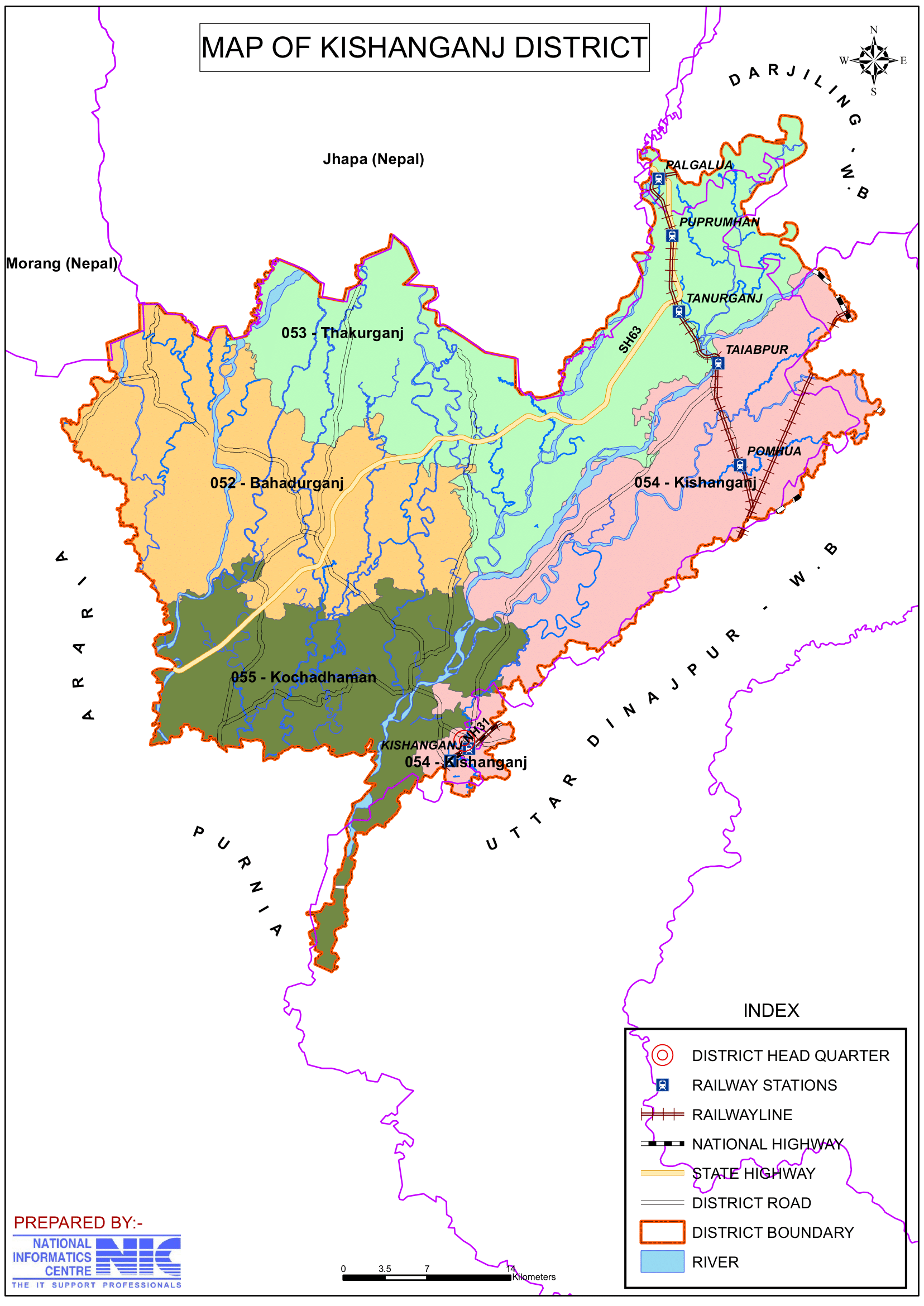
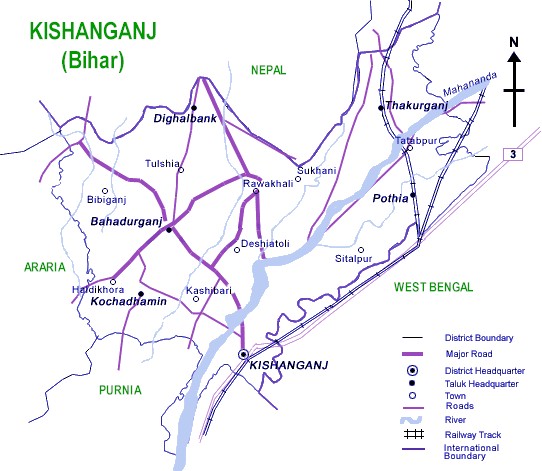
Kishanganj, which was previously an ancient and significant Sub-Division of Purnia district. On 14 January 1990, the Kishanganj district that were separated from Purnia district after a long and difficult effort by the people of Kishanganj, including social workers, legislators, journalists, business people, farmers, and others. The district covers an area of 1,884 km2 (727 sq mi), which bordering Darjeeling district of West Bengal and Nepal to the north, Uttar Dinajpur district of West Bengal to the east, Araria district to the west, and Purnia district to the south-west. The Kishanganj district lies between latitudes 25° 20′ and 26° 30′ north and longitudes 87° 7′ and 88° 19′ east.
Ancient Era
Since the late Vedic era (c. 1100–500 BCE), the District of Kishanganj has been a part of Mithilanchal (Mithila Region). Mithila initially gained to prominence when Indo-Aryans migrated there and founded the Mithila Kingdom, also known as the Kingdom of the Videhas. Videha, Kuru, and Pañcāla emerged as South Asia’s principal centers of culture and politics. The Videha Kingdom’s rulers were known as Janakas. The Videha Kingdom was eventually integrated into the Vajji confederacy, which had its capital in Vaishali, also located in Mithila.
When Mohammed Fakiruddin, a Hindu saint, arrived during the Khagada Nawab era, he was exhausted and wanted to rest here. However, he refused to enter Alamganj after learning that this place name called Alamganj, the river name was called Ramazan and the Jamindar name was called Fakiruddin. After that, the Nawab made a decision and declared Krishna-Kunj, a section from Kishanganj Gudri to Ramzan Pool Gandhi Ghat. Over time, the name changed to Kishanganj as it is now.
Key Facts About Kishanganj District
- Country:
 India
India - State:
 Bihar
Bihar - Region: Mithila
- Division: Purnia
- Coordinates: 26°15′N 87°59′E
- Established: 14 January 1990
- Area: 1,884 km2 (727 sq mi)
- District Headquarters: Kishanganj
- District Magistrate (DM): Shri Vishal Raj, IAS
- Superintendent of Police (SP): Shri Sagar Kumar, IPS
- Population (2011):
- Total: 1,690,400
- Density: 900/km2 (2,300/sq mi)
- Literacy Rate: 57.04%
- Sex Ratio: 946
- Gram Panchayats: 125
- Villages: 802 (approx)
- No. of Subdivision: 1 (Kishanganj)
- No. of Blocks: 7
- Kishanganj- Bahadurganj, Dighalbank, Kishanganj, Kochadhaman, Pothia, Teragacch, Thakurganj
- Police Station: 20
- Municipal Council (Nagar Parishad): 1 (Kishanganj)
- Nagar Panchayat: 2 (Bahadurganj, Thakurganj)
- Rivers: Mahananda, Kankai, Mechi, Donk, Ratua
- Lok Sabha constituency: 1 (Kishanganj)
- Vidhan Sabha constituencies: 4
- 52- Bahdurganj, 53- Thakurganj, 54- Kishanganj, 55- Kochadhaman
- NGOs:
- AFIFA Foundation
- Rahat NGO
- Bhartiye Samriddi Vikas Kalyan Sangthan
- Postal Address:
- Post Office Head Quarter, Near Bus Stand, kishanganj
- Churipatti Post Office
- Gangi Hat Post Office, Gangi, Kishanganj
- Thakurganj Post Office, Thakurganj Market
- Key Features:
- Known for its tea gardens, as it shares proximity with Darjeeling and Assam.
- Predominantly a rural district with a focus on agriculture and trade.
- Houses religious sites such as the Har Gauri Temple and Churli Jamia Masjid.
- Significance: A district with economic potential and cultural diversity.
- Major Highways: NH-31
- Vehicle Registration: BR-37
- Time Zone: UTC+05:30 (IST)
- Official Website: kishanganj.nic.in
Geography
- Location: Kishanganj is situated in the easternmost part of Bihar, bordering Nepal to the north, West Bengal to the east, Araria to the west, and Purnia to the south.
- Area: The district covers an area of approximately 1,884 square kilometers, making it one of Bihar’s smaller districts by land area.
- Rivers: Major rivers include the Mahananda, Mechi, Kankai, Donk, Ratua and Ramzan Sudhani, which support agriculture but also cause seasonal flooding.
- Climate: The district experiences a humid subtropical climate, with heavy monsoons, warm summers, and mild winters.
History
- Ancient and Medieval Periods: Kishanganj has historical connections to the Mithila and Bengal regions. It has been influenced by Hindu, Buddhist, and Islamic cultures over the centuries.
- Colonial Era: During British rule, Kishanganj was part of Purnia district and served as a key transit and trade point due to its strategic location near Nepal and Bengal.
- Formation: Kishanganj became a separate district on 14 January 1990, after being carved out of Purnia district.
Demographics (According to the 2011 Census)
- Population:
- Total Population: Kishanganj district has a population of 1,690,400 (approximately 1.69 million), comparable to the nation of Guinea-Bissau or the US state of Idaho.
- Ranking: 293rd in India (out of 640 districts).
- Population Density: 898 inhabitants per square kilometer (2,570/sq mi).
- Population Growth (2001–2011): 30.44% reflecting significant population increase.
- Sex Ratio: 946 females per 1,000 males, indicating a gender disparity.
- Literacy Rate: The literacy rate is 57.04%, with significant disparities between urban and rural areas, and efforts ongoing to improve educational access in rural areas.
- Urban Population: 9.53% of the total population lives in urban areas.
- Rural Population: A vast majority of the population resides in villages.
- Religious Composition (2011 Census):
- Islam: 67.98%, making Kishanganj the only Muslim-majority district in Bihar.
- Hinduism: 31.43%
- Hindu Minority: Hindus form a significant minority, predominantly from the Surjapuri (Rajbanshi) community.
- Santals: Small pockets of the Santal tribal community also reside in the district.
- Scheduled Castes: 6.69%
- Scheduled Tribes: 3.80%
- Other or not stated: 0.59%
- Languages: The district is linguistically diverse, with Hindi, Bengali, Urdu, Santali, Maithili, Bhojpuri and Surjapuri (a regional dialect) being widely spoken.
- Surjapuri: 42.61% (most widely spoken language)
- Urdu: 32.62%
- Hindi: 9.05%
- Bengali: 6.66%
- Santali: 3.45%
- Maithili: 2.63%
- Bhojpuri: 1.23%
- Others: 1.75%
Administration
- Headquarters: Kishanganj town serves as the district headquarters.
- Subdivisions:
- The district is divided into one subdivision, Kishanganj Sadar, which is further divided into seven blocks.
- Each subdivision is led by a subdivisional magistrate who is in charge of development, revenue-related tasks, and maintaining law and order.
- Blocks and Circles:
- Kishanganj district is divided into 7 Blocks and Circles such as Bahadurganj, Dighalbank, Kishanganj, Kochadhaman, Pothia, Teragacch and Thakurganj.
- A circle officer (CO) leads each circle, while a Block Development Officer (BDO) leads each block.
- Governance: Kishanganj falls under the Purnia division and is represented in both the Bihar Legislative Assembly and the Indian Parliament.
- Lok Sabha constituency: Kishanganj
- Vidhan Sabha constituencies: 4
- 52- Bahdurganj, 53- Thakurganj, 54- Kishanganj, 55- Kochadhaman
Organization Chart

Economy
- Agriculture: The economy is primarily agrarian, with rice, wheat, maize, jute, and pulses as the main crops. The fertile alluvial soil is ideal for farming.
- Tea Plantations: Kishanganj is the only district in Bihar with tea plantations, which are growing in significance as a source of income and employment.
- Trade and Commerce: Its proximity to Nepal, West Bengal, and Bangladesh makes it a regional trade hub for agricultural products and consumer goods.
- Employment: Despite its potential, Kishanganj faces challenges in employment, with many residents migrating to other states for work.
- Backward District Status: In 2006, the Indian government identified Araria as one of the 250 most backward districts in the country (out of 640).
- Funding and Development: Araria is one of the 36 districts in Bihar currently receiving financial support through the Backward Regions Grant Fund Programme (BRGF) to address its socio-economic disparities and promote growth.
Education
Kishanganj district has made strides in education, though rural areas still face challenges in access and infrastructure:
- Aligarh Muslim University (AMU) Center: A significant milestone for the district, the AMU Center in Kishanganj provides higher education opportunities to the local population.
- Sonia Gandhi laid the cornerstone for Aligarh Muslim University’s Kishanganj campus on January 30, 2014.
- Schools and Colleges: A mix of government and private schools, along with degree colleges, cater to the district’s educational needs.
- List of some Colleges:
- Marwari College Kishanganj
- Nehru College, Bahadurganj
- Mata Gujri Medical College
- RK Saha Women College
- List of some Schools:
- DPS Kishanganj
- Girls High School, Kishanganj
- Inter High School, Kishanganj
- GBM School, Hospital Road, Kishanganj
- Insan School, Siksha Nagar, Kishanganj
- Kendriya Vidyalaya, B.S.F Camp Khagra, Kishanganj
- Bethel Mission School, Uttarpali, Fulwari Road, Kishanganj
- Bal Mandir Senior Secondary School, Purab Palli, Kishanganj
- Jawahar Novodaya Vidyalaya, Motihara Taluka, Belwa, Kishanganj
- Crescent Public School, Sir Sayed Nagar, Crescent road, Kishanganj
- List of some Colleges:
- Focus on Literacy: Special initiatives and programs are being undertaken to improve literacy rates, especially among women and marginalized communities.
Culture
- Festivals: The district celebrates festivals like Eid, Durga Puja, Chhath Puja, and Holi with enthusiasm, reflecting its religious and cultural diversity.
- Cuisine: Kishanganj’s cuisine includes a mix of Bihari, Bengali, and Mughlai influences, featuring dishes like litti chokha, pulao, biryani, and sweets like khaja and rasgulla.
- Languages and Arts: The cultural diversity of the district is evident in its languages, folk songs, and traditional crafts.
Tourism
Kishanganj district has several attractions that showcase its natural beauty, religious importance, and historical significance:
- Khagra Mela: A traditional fair that attracts visitors from neighboring regions.
- Hulhulia River: A scenic spot known for its natural beauty.
- Mahananda River: This river is situated 6 km away from Kishanganj Bus stand.
- Tea Gardens: The lush tea plantations offer a unique experience for visitors and highlight Kishanganj’s agricultural diversity.
- Religious Sites: Various temples, mosques, and shrines in the district reflect its cultural harmony and spiritual significance.
Transportation
- Railways: Kishanganj Railway Station belongs to Northeast Frontier Railway (NFR), is a major junction connecting the district to other parts of Bihar, West Bengal, and the northeastern states.
- Direct train services to major cities, including New Delhi, Mumbai, Patna, Kolkata, Guwahati, Bangalore, Chennai, and Trivandrum.
- Rajdhani Express has a stoppage at Kishanganj, connecting New Delhi and Guwahati.
- Garib Nawaz Express originates from Kishanganj and travels to Ajmer.
- Roadways: The district is well-connected by National Highway NH-31, providing road access to neighboring states and cities.
- A crucial and busy national highway NH-31 connecting Kishanganj to other parts of India.
- NH-31 Plays a vital role in facilitating transport and trade in the region.
- Airways: The nearest airports are Bagdogra Airport in West Bengal (about 70 km) and Patna Airport (approximately 400 km).
Challenges
- Flooding: Seasonal floods caused by rivers like the Mahananda disrupt lives and livelihoods in the district.
- Infrastructure: Kishanganj district faces challenges in healthcare, road connectivity, and educational facilities, particularly in rural areas.
- Unemployment: Limited industrial growth and job opportunities lead to high rates of migration for work.
Conclusion
Kishanganj is a district of immense potential, with its strategic location, fertile lands, and unique tea plantations. Its rich cultural heritage and linguistic diversity make it a unique part of Bihar. However, the district faces challenges like floods, underdeveloped infrastructure, and unemployment. With focused government efforts in education, disaster management, and industrialization, Kishanganj can emerge as a key economic and cultural hub in the region.
Would you like more details about any specific Topics on Bihar? Comment Below or checkout these topics
किशनगंज जिला: समृद्ध विविधता और सद्भाव की एक विशेष भूमि
अवलोकन
किशनगंज जिला, भारत के बिहार राज्य के पूर्वोत्तर भाग में स्थित 38वें जिलों में से एक है, जिसका ऐतिहासिक, भौगोलिक और सांस्कृतिक महत्व बहुत बड़ा है। इसे “पूर्वोत्तर का प्रवेश द्वार” के रूप में जाना जाता है, यह पश्चिम बंगाल और नेपाल के साथ सीमा साझा करता है, और बांग्लादेश के भी निकट है। किशनगंज अपनी कृषि अर्थव्यवस्था, सांस्कृतिक विविधता और चाय बागानों के लिए प्रसिद्ध है। जिले का प्रशासनिक केंद्र किशनगंज शहर में स्थित है। यह पूर्णिया संभाग (सीमांचल) के अंतर्गत आने वाले जिलों में से एक है।
किशनगंज, जो पहले पूर्णिया जिले का एक प्राचीन और महत्वपूर्ण उप-विभाग था। 14 जनवरी 1990 को, किशनगंज जिले को सामाजिक कार्यकर्ताओं, विधायकों, पत्रकारों, व्यापारियों, किसानों और अन्य लोगों सहित किशनगंज के लोगों द्वारा लंबे और कठिन प्रयास के बाद पूर्णिया जिले से अलग कर दिया गया था। जिले का क्षेत्रफल 1,884 km2 (727 वर्ग मील) है, जो उत्तर में पश्चिम बंगाल के दार्जिलिंग जिले और नेपाल, पूर्व में पश्चिम बंगाल के उत्तर दिनाजपुर जिले, पश्चिम में अररिया जिले और दक्षिण-पश्चिम में पूर्णिया जिले की सीमा से लगा हुआ है। किशनगंज जिला 25° 20′ और 26° 30′ उत्तरी अक्षांश और 87° 7′ और 88° 19′ पूर्वी देशांतर के बीच स्थित है।
प्राचीन युग
उत्तर वैदिक युग (लगभग 1100-500 ईसा पूर्व) से ही किशनगंज जिला मिथिलांचल (मिथिला क्षेत्र) का हिस्सा रहा है। मिथिला को सबसे पहले तब प्रसिद्धि मिली जब इंडो-आर्यन यहाँ आकर बसे और मिथिला साम्राज्य की स्थापना की, जिसे विदेहों का साम्राज्य भी कहा जाता है। विदेह, कुरु और पंचाल दक्षिण एशिया के संस्कृति और राजनीति के प्रमुख केंद्र के रूप में उभरे। विदेह साम्राज्य के शासकों को जनक के नाम से जाना जाता था। विदेह साम्राज्य को अंततः वज्जि संघ में शामिल कर लिया गया, जिसकी राजधानी वैशाली थी, जो मिथिला में भी स्थित है।
जब खगड़ा नवाब काल में एक हिंदू संत मोहम्मद फकीरुद्दीन यहां आए, तो वे थक गए थे और यहां आराम करना चाहते थे। हालांकि, उन्होंने आलमगंज में प्रवेश करने से इनकार कर दिया, क्योंकि उन्हें पता चला कि इस जगह का नाम आलमगंज है, नदी का नाम रमजान है और जमींदार का नाम फकीरुद्दीन है। उसके बाद, नवाब ने एक निर्णय लिया और किशनगंज गुदरी से रमजान पूल गांधी घाट तक के हिस्से को कृष्ण-कुंज घोषित किया। समय के साथ, नाम बदलकर किशनगंज हो गया जैसा कि अब है।
किशनगंज जिले के बारे में मुख्य तथ्य
- देश: भारत
- राज्य: बिहार
- क्षेत्र: मिथिला
- प्रमंडल: पूर्णिया
- निर्देशांक: 26°15′N 87°59′E
- स्थापित: 14 जनवरी 1990
- क्षेत्रफल: 1,884 km2 (727 वर्ग मील)
- जनसंख्या (2011):
- कुल: 1,690,400
- घनत्व: 900/km2 (2,300/वर्ग मील)
- साक्षरता दर: 57.04%
- लिंगानुपात: 946
- जिला मुख्यालय: किशनगंज
- ग्राम पंचायतें: 125
- गांव: 802 (लगभग)
- उपखंड की संख्या: 1 (किशनगंज)
- ब्लॉकों की संख्या: 7
- बहादुरगंज, दिघलबैंक, किशनगंज, कोचाधामन, पोठिया, टेरागाछ, ठाकुरगंज
- पुलिस स्टेशन: 20
- नगर परिषद: 1 (किशनगंज)
- नगर पंचायत: 2 (बहादुरगंज, ठाकुरगंज)
- नदियाँ: महानंदा, कनकई, मेची, डोंक, रतुआ
- लोकसभा क्षेत्र: 1 (किशनगंज)
- विधानसभा क्षेत्र: 4
- 52- बहादुरगंज, 53- ठाकुरगंज, 54- किशनगंज, 55- कोचाधामन
- गैर सरकारी संगठन:
- अफीफा फाउंडेशन
- राहत एनजीओ
- भारतीय समृद्धि विकास कल्याण संगठन
- डाक का पता:
- डाकघर मुख्यालय, बस स्टैंड के पास, किशनगंज
- चुरीपट्टी डाकघर
- गांगी हाट डाकघर, गांगी, किशनगंज
- ठाकुरगंज डाकघर, ठाकुरगंज बाजार
- प्रमुख विशेषताऐं:
- यह अपने चाय बागानों के लिए जाना जाता है, क्योंकि यह दार्जिलिंग और असम से निकटता साझा करता है।
- मुख्य रूप से कृषि और व्यापार पर ध्यान देने वाला एक ग्रामीण जिला।
- हर गौरी मंदिर और चुरली जामिया मस्जिद जैसे धार्मिक स्थल हैं।
- महत्व: आर्थिक क्षमता और सांस्कृतिक विविधता वाला जिला।
- प्रमुख राजमार्ग: NH-31
- वाहन पंजीकरण: BR-37
- समय क्षेत्र: UTC+05:30 (IST)
- आधिकारिक वेबसाइट: kishanganj.nic.in
भूगोल
- स्थान: किशनगंज बिहार के सबसे पूर्वी भाग में स्थित है, जिसकी सीमा उत्तर में नेपाल, पूर्व में पश्चिम बंगाल, पश्चिम में अररिया और दक्षिण में पूर्णिया से लगती है।
- क्षेत्र: यह जिला लगभग 1,884 वर्ग किलोमीटर में फैला हुआ है, जो इसे भूमि क्षेत्र के हिसाब से बिहार के छोटे जिलों में से एक बनाता है।
- नदियाँ: प्रमुख नदियों में महानंदा, मेची, कंकई, डोंक, रतुआ और रमजान सुधानी शामिल हैं, जो कृषि को बढ़ावा देती हैं, लेकिन मौसमी बाढ़ का कारण भी बनती हैं।
- जलवायु: जिले में आर्द्र उपोष्णकटिबंधीय जलवायु होती है, जिसमें भारी मानसून, गर्म ग्रीष्मकाल और हल्की सर्दियाँ होती हैं।
इतिहास
- प्राचीन और मध्यकालीन काल: किशनगंज का मिथिला और बंगाल क्षेत्रों से ऐतिहासिक संबंध है। यह सदियों से हिंदू, बौद्ध और इस्लामी संस्कृतियों से प्रभावित रहा है।
- औपनिवेशिक युग: ब्रिटिश शासन के दौरान, किशनगंज पूर्णिया जिले का हिस्सा था और नेपाल और बंगाल के पास अपनी रणनीतिक स्थिति के कारण एक प्रमुख पारगमन और व्यापार बिंदु के रूप में कार्य करता था।
- गठन: 14 जनवरी 1990 को पूर्णिया जिले से अलग होकर किशनगंज एक अलग जिला बन गया।
जनसांख्यिकी (2011 की जनगणना के अनुसार)
- जनसंख्या:
- कुल जनसंख्या: किशनगंज जिले की जनसंख्या 1,690,400 (लगभग 1.69 मिलियन) है, जो गिनी-बिसाऊ राष्ट्र या अमेरिकी राज्य इडाहो के बराबर है।
- रैंकिंग: भारत में 293वाँ (640 जिलों में से)।
- जनसंख्या घनत्व: प्रति वर्ग किलोमीटर 898 निवासी (2,570/वर्ग मील)।
- जनसंख्या वृद्धि (2001-2011): 30.44% जो महत्वपूर्ण जनसंख्या वृद्धि को दर्शाता है।
- लिंग अनुपात: प्रति 1,000 पुरुषों पर 946 महिलाएँ, जो लिंग असमानता को दर्शाता है।
- साक्षरता दर: साक्षरता दर 57.04% है, शहरी और ग्रामीण क्षेत्रों के बीच महत्वपूर्ण असमानताएँ हैं, और ग्रामीण क्षेत्रों में शिक्षा की पहुँच में सुधार के लिए प्रयास जारी हैं।
- शहरी जनसंख्या: कुल जनसंख्या का 9.53% शहरी क्षेत्रों में रहता है।
- ग्रामीण जनसंख्या: अधिकांश आबादी गाँवों में रहती है।
- धार्मिक संरचना (2011 की जनगणना):
- इस्लाम: 67.98%, जो किशनगंज को बिहार का एकमात्र मुस्लिम बहुल जिला बनाता है।
- हिंदू धर्म: 31.43%
- हिंदू अल्पसंख्यक: हिंदू एक महत्वपूर्ण अल्पसंख्यक हैं, मुख्य रूप से सुरजापुरी (राजबंशी) समुदाय से।
- संथाल: संथाल आदिवासी समुदाय के छोटे-छोटे समूह भी जिले में रहते हैं।
- अनुसूचित जाति: 6.69%
- अनुसूचित जनजातियाँ: 3.80%
- अन्य या नहीं बताया गया: 0.59%
- भाषाएँ: जिला भाषाई रूप से विविध है, जिसमें हिंदी, बंगाली, उर्दू, संताली, मैथिली, भोजपुरी और सुरजापुरी (एक क्षेत्रीय बोली) व्यापक रूप से बोली जाती है।
- सुरजापुरी: 42.61% (सबसे अधिक बोली जाने वाली भाषा)
- उर्दू: 32.62%
- हिंदी: 9.05%
- बंगाली: 6.66%
- संताली: 3.45%
- मैथिली: 2.63%
- भोजपुरी: 1.23%
- अन्य: 1.75%
प्रशासन
- मुख्यालय: किशनगंज शहर जिला मुख्यालय के रूप में कार्य करता है।
- उपखंड:
- जिले को एक उपखंड, किशनगंज सदर में विभाजित किया गया है, जिसे आगे सात ब्लॉकों में विभाजित किया गया है।
- प्रत्येक उपखंड का नेतृत्व एक उपखंड मजिस्ट्रेट करता है जो विकास, राजस्व-संबंधी कार्यों और कानून व्यवस्था बनाए रखने का प्रभारी होता है।
- ब्लॉक और सर्किल:
- किशनगंज जिले को बहादुरगंज, दिघलबैंक, किशनगंज, कोचाधामन, पोठिया, तेरागाछ और ठाकुरगंज जैसे 7 ब्लॉक और सर्किल में विभाजित किया गया है।
- प्रत्येक सर्किल का नेतृत्व एक सर्किल अधिकारी (सीओ) करता है, जबकि प्रत्येक ब्लॉक का नेतृत्व एक ब्लॉक विकास अधिकारी (बीडीओ) करता है।
- शासन: किशनगंज पूर्णिया डिवीजन के अंतर्गत आता है और इसका प्रतिनिधित्व बिहार विधानसभा और भारतीय संसद दोनों में होता है।
- लोकसभा क्षेत्र: किशनगंज
- विधान सभा क्षेत्र: 4
- 52- बहादुरगंज, 53- ठाकुरगंज, 54- किशनगंज, 55- कोचाधामन
अर्थव्यवस्था
- कृषि: अर्थव्यवस्था मुख्य रूप से कृषि आधारित है, जिसमें चावल, गेहूं, मक्का, जूट और दालें मुख्य फसलें हैं। उपजाऊ जलोढ़ मिट्टी खेती के लिए आदर्श है।
- चाय बागान: किशनगंज बिहार का एकमात्र जिला है, जहां चाय के बागान हैं, जो आय और रोजगार के स्रोत के रूप में महत्वपूर्ण होते जा रहे हैं।
- व्यापार और वाणिज्य: नेपाल, पश्चिम बंगाल और बांग्लादेश से इसकी निकटता इसे कृषि उत्पादों और उपभोक्ता वस्तुओं के लिए एक क्षेत्रीय व्यापार केंद्र बनाती है।
- रोजगार: अपनी क्षमता के बावजूद, किशनगंज को रोजगार में चुनौतियों का सामना करना पड़ता है, क्योंकि कई निवासी काम के लिए दूसरे राज्यों में पलायन करते हैं।
- पिछड़े जिले का दर्जा: 2006 में, भारत सरकार ने अररिया को देश के 250 सबसे पिछड़े जिलों (640 में से) में से एक के रूप में पहचाना।
- वित्त पोषण और विकास: अररिया बिहार के उन 36 जिलों में से एक है, जिन्हें वर्तमान में पिछड़ा क्षेत्र अनुदान निधि कार्यक्रम (BRGF) के माध्यम से वित्तीय सहायता मिल रही है, ताकि इसकी सामाजिक-आर्थिक विषमताओं को दूर किया जा सके और विकास को बढ़ावा दिया जा सके।
शिक्षा
किशनगंज ने शिक्षा के क्षेत्र में प्रगति की है, हालांकि ग्रामीण क्षेत्रों में अभी भी पहुंच और बुनियादी ढांचे में चुनौतियों का सामना करना पड़ रहा है:
- अलीगढ़ मुस्लिम विश्वविद्यालय (AMU) केंद्र: जिले के लिए एक महत्वपूर्ण मील का पत्थर, किशनगंज में AMU केंद्र स्थानीय आबादी को उच्च शिक्षा के अवसर प्रदान करता है।
- सोनिया गांधी ने 30 जनवरी, 2014 को अलीगढ़ मुस्लिम विश्वविद्यालय के किशनगंज परिसर की आधारशिला रखी।
- स्कूल और कॉलेज: सरकारी और निजी स्कूलों के साथ-साथ डिग्री कॉलेज भी जिले की शैक्षिक आवश्यकताओं को पूरा करते हैं।
- कुछ कॉलेजों की सूची:
- मारवाड़ी कॉलेज किशनगंज
- नेहरू कॉलेज, बहादुरगंज
- माता गुजरी मेडिकल कॉलेज
- आरके साहा महिला कॉलेज
- कुछ स्कूलों की सूची:
- डीपीएस किशनगंज
- गर्ल्स हाई स्कूल, किशनगंज
- इंटर हाई स्कूल, किशनगंज
- जीबीएम स्कूल, हॉस्पिटल रोड, किशनगंज
- इंसान स्कूल, शिक्षा नगर, किशनगंज
- केन्द्रीय विद्यालय, बी.एस.एफ कैंप खगड़ा, किशनगंज
- बेथेल मिशन स्कूल, उत्तरपाली, फुलवारी रोड, किशनगंज
- बाल मंदिर सीनियर सेकेंडरी स्कूल, पूरब पल्ली, किशनगंज
- जवाहर नवोदय विद्यालय, मोतिहारा तालुका, बेलवा, किशनगंज
- क्रिसेंट पब्लिक स्कूल, सर सैयद नगर, क्रिसेंट रोड, किशनगंज
- कुछ कॉलेजों की सूची:
- साक्षरता पर ध्यान: विशेषकर महिलाओं और हाशिए पर रहने वाले समुदायों के बीच साक्षरता दर में सुधार के लिए विशेष पहल और कार्यक्रम चलाए जा रहे हैं।
संस्कृति
- त्यौहार: जिला ईद, दुर्गा पूजा, छठ पूजा और होली जैसे त्यौहारों को उत्साह के साथ मनाता है, जो इसकी धार्मिक और सांस्कृतिक विविधता को दर्शाता है।
- भोजन: किशनगंज के भोजन में बिहारी, बंगाली और मुगलई प्रभावों का मिश्रण शामिल है, जिसमें लिट्टी चोखा, पुलाव, बिरयानी जैसे व्यंजन और खाजा और रसगुल्ला जैसी मिठाइयाँ शामिल हैं।
- भाषाएँ और कलाएँ: जिले की सांस्कृतिक विविधता इसकी भाषाओं, लोकगीतों और पारंपरिक शिल्पों में स्पष्ट है।
पर्यटन
किशनगंज में कई आकर्षण हैं जो इसकी प्राकृतिक सुंदरता, धार्मिक महत्व और ऐतिहासिक महत्व को दर्शाते हैं:
- खगरा मेला: एक पारंपरिक मेला जो पड़ोसी क्षेत्रों से आगंतुकों को आकर्षित करता है।
- हुलहुलिया नदी: अपनी प्राकृतिक सुंदरता के लिए जाना जाने वाला एक दर्शनीय स्थल।
- महानंदा नदी: यह नदी किशनगंज बस स्टैंड से 6 किमी दूर स्थित है।
- चाय के बागान: हरे-भरे चाय के बागान आगंतुकों को एक अनूठा अनुभव प्रदान करते हैं और किशनगंज की कृषि विविधता को उजागर करते हैं।
- धार्मिक स्थल: जिले में विभिन्न मंदिर, मस्जिद और तीर्थस्थल इसकी सांस्कृतिक सद्भाव और आध्यात्मिक महत्व को दर्शाते हैं।
परिवहन
- रेलवे: किशनगंज रेलवे स्टेशन पूर्वोत्तर सीमांत रेलवे (एनएफआर) से संबंधित है, यह जिले को बिहार, पश्चिम बंगाल और पूर्वोत्तर राज्यों के अन्य हिस्सों से जोड़ने वाला एक प्रमुख जंक्शन है।
- नई दिल्ली, मुंबई, पटना, कोलकाता, गुवाहाटी, बैंगलोर, चेन्नई और त्रिवेंद्रम सहित प्रमुख शहरों के लिए सीधी ट्रेन सेवाएँ।
- राजधानी एक्सप्रेस का किशनगंज में ठहराव है, जो नई दिल्ली और गुवाहाटी को जोड़ती है।
- गरीब नवाज एक्सप्रेस किशनगंज से शुरू होती है और अजमेर जाती है।
- सड़क मार्ग: जिला राष्ट्रीय राजमार्ग NH-31 द्वारा अच्छी तरह से जुड़ा हुआ है, जो पड़ोसी राज्यों और शहरों तक सड़क पहुँच प्रदान करता है।
- एक महत्वपूर्ण और व्यस्त राष्ट्रीय राजमार्ग NH-31 किशनगंज को भारत के अन्य हिस्सों से जोड़ता है।
- NH-31 क्षेत्र में परिवहन और व्यापार को सुविधाजनक बनाने में महत्वपूर्ण भूमिका निभाता है।
- वायुमार्ग: निकटतम हवाई अड्डे पश्चिम बंगाल में बागडोगरा हवाई अड्डा (लगभग 70 किमी) और पटना हवाई अड्डा (लगभग 400 किमी) हैं।
चुनौतियाँ
- बाढ़: महानंदा जैसी नदियों के कारण होने वाली मौसमी बाढ़ से जिले में जीवन और आजीविका बाधित होती है।
- बुनियादी ढाँचा: किशनगंज को स्वास्थ्य सेवा, सड़क संपर्क और शैक्षिक सुविधाओं में चुनौतियों का सामना करना पड़ता है, खासकर ग्रामीण क्षेत्रों में।
- बेरोज़गारी: सीमित औद्योगिक विकास और नौकरी के अवसरों के कारण काम के लिए पलायन की दर बहुत अधिक है।
निष्कर्ष
किशनगंज अपनी रणनीतिक स्थिति, उपजाऊ भूमि और अद्वितीय चाय बागानों के साथ अपार संभावनाओं वाला जिला है। इसकी समृद्ध सांस्कृतिक विरासत और भाषाई विविधता इसे बिहार का एक अनूठा हिस्सा बनाती है। हालाँकि, जिले को बाढ़, अविकसित बुनियादी ढाँचे और बेरोज़गारी जैसी चुनौतियों का सामना करना पड़ता है। शिक्षा, आपदा प्रबंधन और औद्योगीकरण में केंद्रित सरकारी प्रयासों के साथ, किशनगंज इस क्षेत्र में एक प्रमुख आर्थिक और सांस्कृतिक केंद्र के रूप में उभर सकता है।
क्या आप बिहार के किसी विशेष विषय के बारे में अधिक जानकारी चाहते हैं? नीचे टिप्पणी करें 😊
पदानुक्रमिक संरचना: बिहार का विस्तृत रोडमैप
बिहार में प्रमंडल और उसके जिलों का विवरण
Important Links
𝕋𝕙𝕒𝕟𝕜 𝕐𝕠𝕦 𝔽𝕠𝕣 𝕍𝕚𝕤𝕚𝕥𝕚𝕟𝕘 𝕆𝕦𝕣 𝕎𝕖𝕓𝕤𝕚𝕥𝕖𝕤 🙂
4 thoughts on “Kishanganj District: A Special Land of Diversity and Harmony”