
Sheohar District: An Overview
Sheohar District is one of the smallest among 38-districts, located in north part of Bihar state, India, known for its agricultural economy, cultural heritage, and historical significance. Spanning an area of 443 square kilometers (171.04 square miles), Sitamarhi lies at 26° 30′ 52.5132” N latitude and 85° 17′ 39.2208” E longitude, and shares borders with Sitamarhi district to the north and east, Muzaffarpur district to the south, and East Champaran district to the west. The district’s administrative headquarters is located at Sheohar town. The region is part of the Tirhut Division.
On October 6 1994, Sheohar an independent district, was officially carved out of Sitamarhi district, following a government notification. It is the smallest district in Bihar in terms of both population and area. As per the 2011 Census, district has a population of 656,246, making it the second least populous district in Bihar after Sheikhpura district. Despite its small size, Sheohar has a rich history and is an important region in terms of fertile agricultural land and traditional rural lifestyle.
Creation of District
The creation of Sheohar as a separate district was largely driven by the efforts of Raghunath Jha, a former Union Minister. The first District Magistrate of Sheohar was Dr. Bhagwati Sharan Mishra, a renowned Hindi novelist. Historically, the Mehsi town in East Champaran housed a guest house used by local rulers (Shivas), which still exists today as Raja Bazar.
Though small in size, Sheohar holds immense historical, cultural, and religious significance. Its lush green landscape, deep-rooted Hindu traditions, and agricultural prominence make it a unique part of Bihar. While flooding remains a major challenge, Sheohar continues to thrive as a peaceful and spiritually significant district.
The name Sheohar is derived from Shiva and Har, both referring to Lord Shiva, highlighting the district’s religious heritage. Sheohar is known for its numerous Shiva temples, with Devkuli being a major pilgrimage site, famous for its ancient Lord Shiva temple. The district is renowned for its greenery and cleanliness, with Cadamba and Teak being the principal trees. The Nilgai (blue bull) is the most common regional animal.
Agriculture is the primary occupation of Sheohar’s residents. However, the district is one of the most flood-prone areas in Bihar, frequently affected by the overflowing of the Bagmati and Budhi Gandak rivers. Despite these challenges, the region remains a significant agricultural and religious hub.
Key Facts About Sheohar District
- Country:
 India
India - State:
 Bihar
Bihar - Region: Mithila
- Division: Tirhut
- Established: October 6 1994
- Area: 443 km2 (171.04 sq mi)
- District Headquarters: Sheohar town
- District Magistrate: Vivek Ranjan Maitrey, IAS
- Superitendent of Police: Shailesh Kumar Sinha, IPS
- Population:
- Total: 656,246
- Density: 1,900/km2 (4,900/sq mi)
- Literacy Rate: 72%
- Sex Ratio: 893/1000
- No. of Subdivision: 1 (Sheohar)
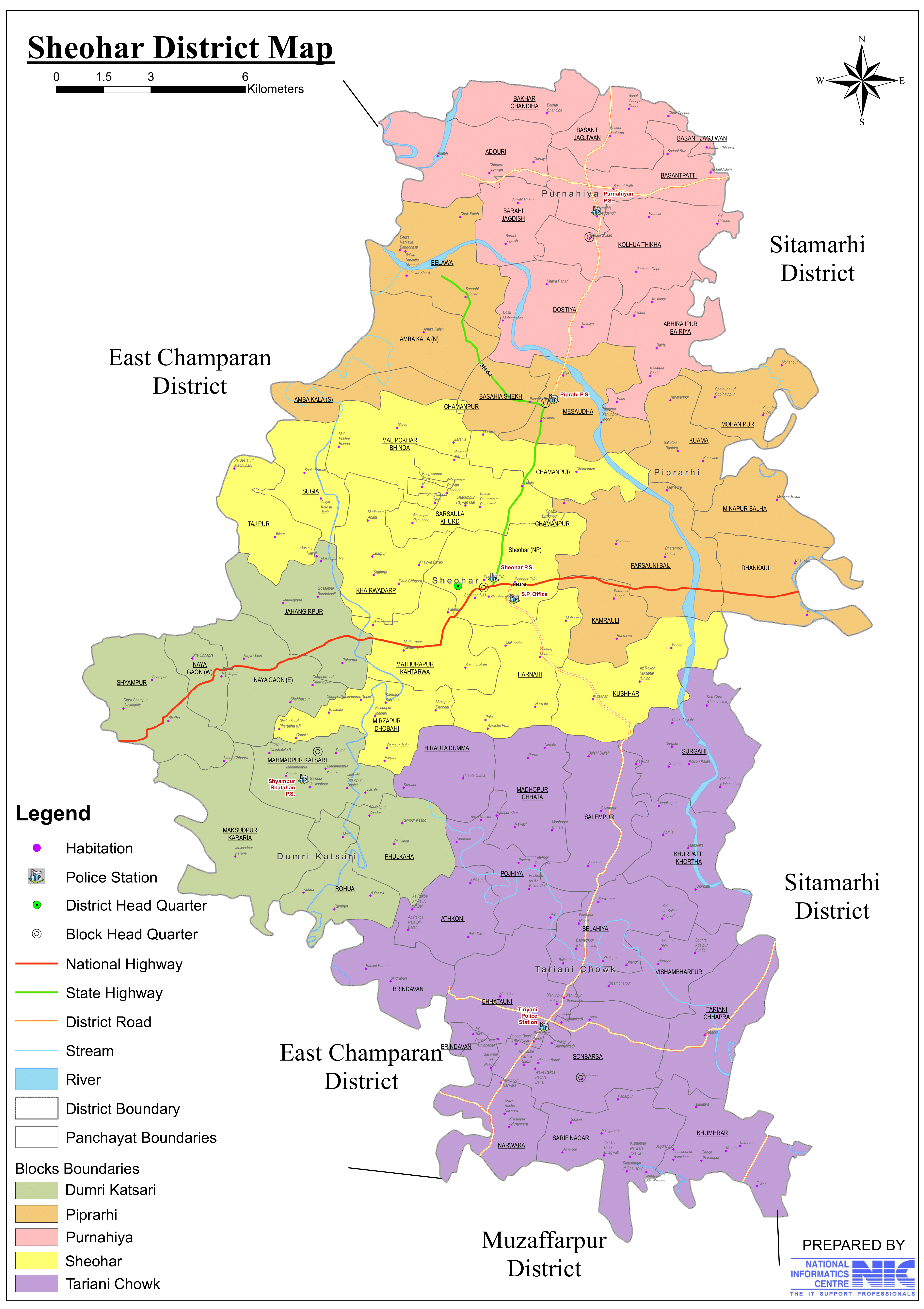
- No. of Blocks: 5 (Sheohar, Tariyani, Piprahi, Dumri-katsari, Purnahiya)
- Gram Panchayats: 53
- Villages: 203
- Municipal council (Nagar Parishad): 1 (Sheohar)
- Police Station: 12
- Sheohar, Fatehpur, Tariyani, Hiramma, Tariyani Chhapra, Purnahiya, Piprahi, Shyampur Bhataha, Traffic P.S, Sheohar Cyber P.S, SC/ST P.S, Mahila P.S
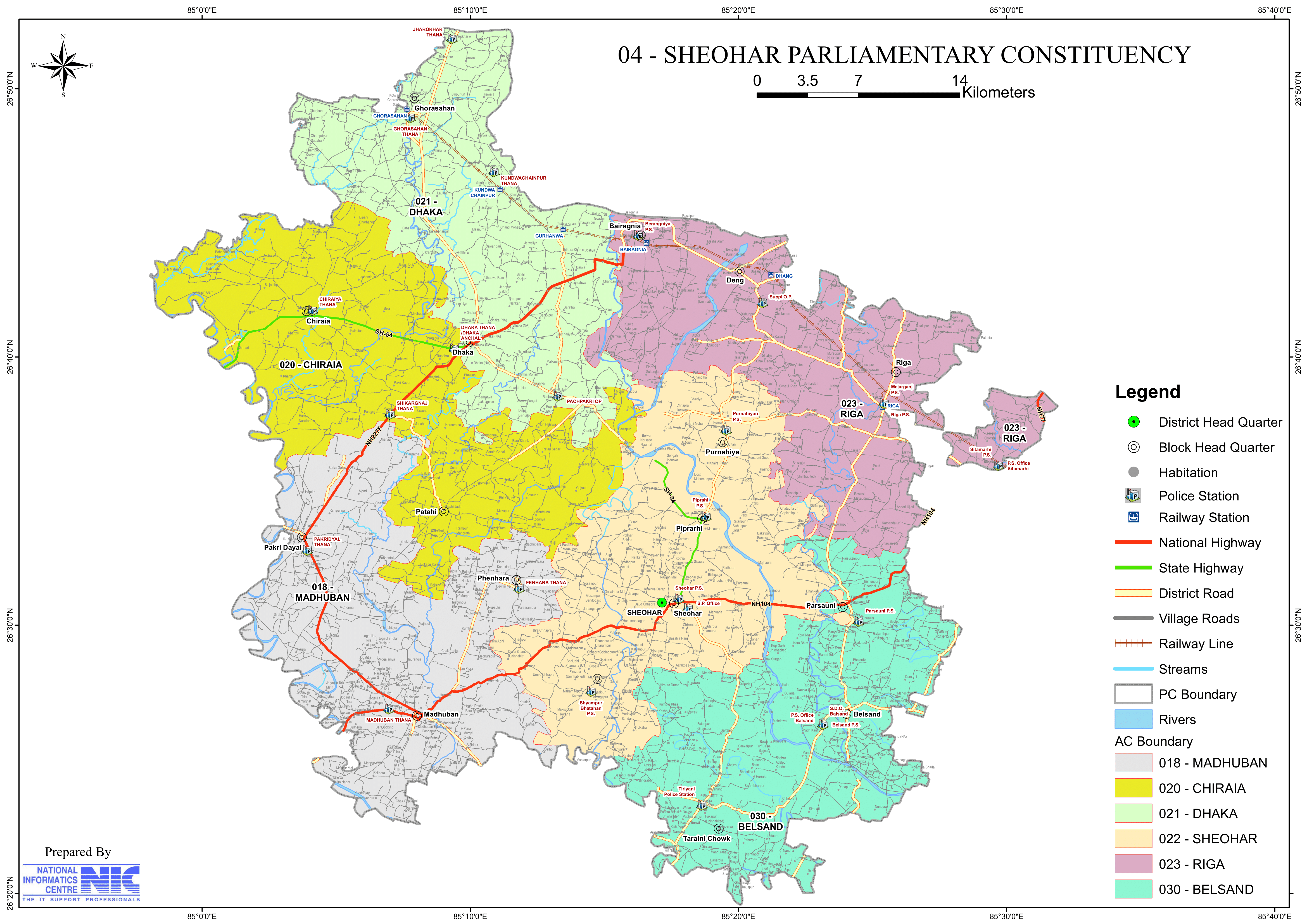
- Lok Sabha constituency: 1 (04-Sheohar)
- Vidhan Sabha constituencies: 2 (22-Sheohar and 30-Belsand(Part))
- Key Features:
- Smallest district in Tirhut Division.
- Known for its scenic beauty and fertile plains.
- Primarily an agrarian economy with paddy and sugarcane cultivation.
- Significance: A developing district with a focus on agriculture.
- Time Zone: UTC+05:30 (IST)
- Pin Code: 8433XX
- Major Highways:
- Gorakhpur – Siliguri Expressway, SH-54, NH-227, Ram – Janki Marg, Mehsi – Sheohar Rd, Sheohar – Muzaffarpur Expressway.
- Average annual precipitation: 720.4 mm
- Official Website: sheohar.nic.in
Geography
- Location: Sheohar is located in north Bihar, sharing borders with:
- Sitamarhi (east & south)
- East Champaran (west)
- Nepal (north, through Sitamarhi)
- Area: 443 square kilometers, making it the smallest district in Bihar.
- Topography:
- Fertile alluvial plains of the Gangetic belt.
- Flat agricultural land with high productivity.
- Climate:
- Humid subtropical climate with hot summers, a monsoon season (June-September), and mild winters.
- Rivers:
- Bagmati River flows through Sheohar, providing irrigation but also causing floods during monsoons.
- The Sheohar District’s most flooded regions include Belwa Ghat and Indarwa Khurd.
History
Ancient Period
- Sheohar was part of the Mithila region, known for its cultural and historical significance in Hinduism.
- It was under the rule of the Maurya and Gupta dynasties.
Medieval Period
- The region saw influence from the Delhi Sultanate and the Mughals.
- It was an important trade and agricultural center during these times.
Modern Era
- Sheohar was previously part of Sitamarhi district.
- It became an independent district on October 6, 1994.
Demographics (As per 2011 Census)
- Population:
- Total Population: Sheohar district has a population of approximately 656,246.
- Population Male: 346673
- Population Female: 309573
- Ranking: 511th in India (out of 640 districts).
- Density: 1,882 persons per square kilometer (4,900/sq mi).
- Population Growth (2001–2011): 27.32% reflecting significant population increase.
- Sex Ratio: 893 females per 1,000 males, indicating a gender disparity.
- Literacy Rate: 54.57%, which is below the national and state average but with significant efforts being made to improve education access and quality.
- Male Literacy Rate : 61.31%
- Female Literacy Rate: 45.26%
- Urban Population: 4.29% of the total population lives in urban areas.
- Total Population: Sheohar district has a population of approximately 656,246.
- Religious Composition (2011 Census): The majority of the population follows Hinduism, with a significant Muslim community.
- Hinduism: 84.19%
- Scheduled Castes: 14.73%
- Scheduled Tribes: 0.05%
- Islam: 15.14%
- Other or not stated: 0.67%
- Languages: Hindi, Maithili, and Bhojpuri are widely spoken.
- Other ‘Hindi’: 68.70%
- Hindi: 22.97%
- Urdu: 7.78%
- Others: 0.55%
Administration
- Headquarters: Sheohar town
- Subdivisions:
- The district has one subdivision – Sheohar Sadar.
- Each subdivision is led by a subdivisional magistrate who is in charge of development, revenue-related tasks, and maintaining law and order.
- Blocks and Circles:
- Sheohar district comprises 5 administrative Blocks and Circles such as Sheohar, Tariyani, Piprahi, Dumri-katsari and Purnahiya, each responsible for local governance and development.
- A Circle officer (CO) leads each circle, while a Block Development Officer (BDO) leads each block.
- Lok Sabha Constituency: Sheohar Parliamentary seat represents the district.
- Vidhan Sabha Constituency: One assembly seat – Sheohar.
Organization Chart

Economy
Agriculture
- Agriculture is the backbone of Sheohar’s economy, with crops like:
- Paddy, wheat, maize, pulses, and oilseeds.
- Sugarcane and vegetables are also grown in large quantities.
- Challenges in Agriculture:
- Frequent flooding from the Bagmati River damages crops.
- Lack of modern irrigation facilities.
Small-Scale Industries
- Handicrafts and cottage industries provide employment to rural populations.
- Dairy farming and animal husbandry are additional sources of livelihood.
- Limited Industrialization:
- The district lacks large industries, leading to high migration for jobs.
Trade and Commerce
- The district has a small local market, with trade largely dependent on nearby Sitamarhi and Muzaffarpur.
Economic Challenges & Government Initiatives
- In 2006, the Ministry of Panchayati Raj identified Sheohar as one of the 250 most backward districts in India (out of 640 districts).
- Sheohar is among the 38 districts in Bihar currently receiving financial aid under the Backward Regions Grant Fund Programme (BRGF).
- Flooding is a recurring problem, damaging crops and infrastructure.
- Industrial development is minimal, leading to high migration for jobs.
Education
- Government & Private Schools:
- Sheohar has many primary and secondary schools, but higher education facilities are limited.
- Nawab High School Block-Sheohar, District-Sheohar
- Sheohar has many primary and secondary schools, but higher education facilities are limited.
- Colleges:
- The district has a few colleges affiliated with Babasaheb Bhimrao Ambedkar Bihar University (BRABU), Muzaffarpur.
- Government diploma college
- Challenges:
- Poor literacy rate, especially among women.
- Lack of professional and technical education institutes.
Culture
Festivals
- Chhath Puja, Durga Puja, Diwali, Holi, and Eid are celebrated with great enthusiasm.
- Local fairs and religious gatherings are common.
Cuisine
- Traditional dishes include:
- Litti Chokha, Sattu Paratha, Dal Pitha, and Thekua.
- Sweets like Balushahi and Khaja are popular.
Folk Traditions
- Maithili folk songs and dances, such as Jat-Jatin and Jhijhiya, are part of Sheohar’s cultural identity.
Tourism
Sheohar is not widely known for tourism, but it has a few sites of religious and cultural significance:
- Bagmati River Ghats
- Sacred ghats where Chhath Puja and other Hindu rituals are performed.
- Durga Mandir, Sheohar
- A popular Hindu temple, attracting devotees year-round.
- Jama Masjid, Sheohar
- A significant mosque, reflecting the district’s religious diversity.
Nearby Attractions:
Pilgrims visiting Sitamarhi (Janaki Mandir) often pass through Sheohar.
Dekuli Shiv Mandir (Baba Bhawaneshwar Nath Temple), Sitamarhi
Dekuli Shiv Mandir, also known as Baba Bhawaneshwar Nath Temple, is one of the oldest and most revered Shiva temples in the Sitamarhi district of Bihar. The temple holds immense religious and historical significance, believed to have been constructed during the Dwapar Yuga (the era of Lord Krishna).
Historical Significance
- Ancient Stone-Carved Structure: The temple was carved from a single stone, making it a unique architectural marvel.
- Mention in British Gazette (1956): The British Gazette described the temple as a sacred site, placing it between Pashupatinath Temple (Nepal) and the Harihar region (India).
- Recognition by Calcutta High Court: In a legal decision, the Calcutta High Court recognized the temple as an ancient religious site.
- Mention in East India Company Records: According to local villagers, the temple was referenced on proclamation receipts of the East India Company.
Archaeological Discoveries
- In 1962, Saint Prem Bhikshu from Chhatouni village led an excavation near the temple.
- The excavation unearthed rare metal sculptures from the Dwapar period, which were later placed near an ancient Mool tree.
- Villagers believe that granite stones can still be found by digging 12 feet below the surface.
Religious & Spiritual Importance
- Sri Yantra & Shivlinga: The Sri Yantra, placed above the temple, is considered extremely powerful. It is believed that any wish made after performing Jalabhishek (holy water offering) to the Shivlinga is fulfilled.
- Sacred Pond: A pond located to the west of the temple is considered holy and spiritually significant.
Temple & Governance
- A petition was sent to the Bihar Government and Government of India to include the temple under the Religious Trust Board.
- Efforts were made to link the temple to Janaki Circuit and Chitrakoot Circuit due to its historical and religious significance.
- However, disputes arose as local Mahants claimed the temple as personal property, creating some confusion regarding its official status.
- Despite governance issues, devotees continue to worship freely at the temple.
Why Visit Dekuli Shiv Mandir?
- One of the oldest Shiva temples, dating back to the Dwapar Yuga.
- Recognized by historical records, including the British Gazette & Calcutta High Court.
- Unique stone-carved temple architecture.
- Powerful Sri Yantra & sacred pond.
- Believed to fulfill wishes through Jalabhishek to Lord Shiva.
Dekuli Shiv Mandir is a must-visit for devotees, historians, and spiritual seekers, offering a blend of history, mythology, and divine energy.
Transportation
Roadways
- Connected by NH-104 to major cities like Sitamarhi, Muzaffarpur, and Patna.
- State highways provide access to neighboring districts.
- Bus and private vehicle services are the main modes of transport.
Railways
- Sheohar does not have a major railway station.
- The nearest railway station is Sitamarhi Junction (25 km away).
Airways
- Nearest Airport:
- Darbhanga Airport (90 km away) – for domestic flights.
- Patna Airport (140 km away) – for better connectivity.
Notable People from Sheohar
Sheohar has been home to several freedom fighters, political leaders, and diplomats who have contributed significantly to India’s independence, governance, and cooperative movements.
Freedom Fighters & Political Leaders
1. Thakur Jugal Kishore Sinha
- Freedom Fighter and Member of the 1st Lok Sabha.
- Popularly known as the “Father of the Cooperative Movement” in India.
2. Ram Dulari Sinha
- Freedom Fighter, Former Union Minister, and Governor.
- First woman from Bihar to serve as a Governor.
3. Raghunath Jha
- Former Union Minister and an influential leader.
- Known as the creator of Sheohar District.
4. Hari Kishore Singh
- Former Ambassador of Syria.
- Prominent diplomat representing India’s interests abroad.
5. Anwarul Haque
- Former Member of Parliament (MP) from Sheohar.
6. Sitaram Singh
- Former Member of Parliament (MP) from Sheohar.
7. Rama Devi
- Former Member of Parliament (MP) from Sheohar.
Current Political Representatives
8. Lovely Anand
- Current Member of Parliament (MP) from Sheohar (JDU, NDA alliance).
9. Chetan Anand
- Current Member of the Legislative Assembly (MLA) from Sheohar (JDU, NDA alliance).
Legacy & Contributions
- These eminent personalities have played key roles in India’s freedom struggle, cooperative development, governance, and international diplomacy.
- Their contributions continue to shape Bihar’s political and social landscape.
Challenges
- Flooding
- The Bagmati River causes annual floods, damaging agriculture and homes.
- Limited Industrial Growth
- Lack of large industries results in high unemployment and migration.
- Poor Infrastructure
- Limited healthcare and educational institutions in rural areas.
- Low Literacy Rate
- Female literacy is especially low, and higher education opportunities are scarce.
Conclusion
Sheohar is a small but significant district of Bihar with a strong agricultural base and rich cultural traditions. However, flooding, unemployment, lack of higher education, and poor industrialization remain major challenges. Investments in flood control, education, and industry can help Sheohar develop into a more prosperous district while preserving its heritage and traditions.
Would you like more details about any specific Topics on Bihar? Comment Below or Checkout these topics
शिवहर जिला: क्षेत्र के विशेष महत्व को जानें
अवलोकन
शिवहर जिला भारत के बिहार राज्य के उत्तरी-भाग में स्थित 38-जिलों में से सबसे छोटा जिला है, जो अपनी कृषि अर्थव्यवस्था, सांस्कृतिक विरासत और ऐतिहासिक महत्व के लिए जाना जाता है। 443 वर्ग किलोमीटर (171.04 वर्ग मील) के क्षेत्र में फैला सीतामढ़ी 26° 30′ 52.5132” उत्तरी अक्षांश और 85° 17′ 39.2208” पूर्वी देशांतर पर स्थित है, और उत्तर और पूर्व में सीतामढ़ी जिले, दक्षिण में मुजफ्फरपुर जिले और पश्चिम में पूर्वी चंपारण जिले के साथ सीमा साझा करता है। जिले का प्रशासनिक मुख्यालय शिवहर शहर में स्थित है। यह क्षेत्र तिरहुत प्रमंडल का हिस्सा है।
6 अक्टूबर 1994 को, एक सरकारी अधिसूचना के बाद, शिवहर एक स्वतंत्र जिला था, जिसे आधिकारिक तौर पर सीतामढ़ी जिले से अलग कर दिया गया था। यह जनसंख्या और क्षेत्रफल दोनों के मामले में बिहार का सबसे छोटा जिला है। 2011 की जनगणना के अनुसार, जिले की जनसंख्या 656,246 है, जो इसे शेखपुरा जिले के बाद बिहार का दूसरा सबसे कम आबादी वाला जिला बनाता है। अपने छोटे आकार के बावजूद, शिवहर का इतिहास समृद्ध है और उपजाऊ कृषि भूमि और पारंपरिक ग्रामीण जीवन शैली के मामले में यह एक महत्वपूर्ण क्षेत्र है।
जिले का निर्माण
शिवहर को एक अलग जिले के रूप में बनाने का मुख्य कारण रघुनाथ झा, एक पूर्व केंद्रीय मंत्री थे। शिवहर के पहले जिला मजिस्ट्रेट डॉ. भगवती शरण मिश्र थे, जो एक प्रसिद्ध हिंदी उपन्यासकार थे। ऐतिहासिक रूप से, पूर्वी चंपारण के मेहसी शहर में स्थानीय शासकों (शिवों) द्वारा इस्तेमाल किया जाने वाला एक गेस्ट हाउस था, जो आज भी राजा बाजार के रूप में मौजूद है।
आकार में छोटा होने के बावजूद, शिवहर का ऐतिहासिक, सांस्कृतिक और धार्मिक महत्व बहुत अधिक है। इसका हरा-भरा परिदृश्य, गहरी जड़ें वाली हिंदू परंपराएँ और कृषि प्रधानता इसे बिहार का एक अनूठा हिस्सा बनाती हैं। जबकि बाढ़ एक बड़ी चुनौती बनी हुई है, शिवहर एक शांतिपूर्ण और आध्यात्मिक रूप से महत्वपूर्ण जिले के रूप में फल-फूल रहा है।
शिवहर नाम शिव और हर से लिया गया है, दोनों भगवान शिव को संदर्भित करते हैं, जो जिले की धार्मिक विरासत को उजागर करता है। शिवहर अपने कई शिव मंदिरों के लिए जाना जाता है, जिसमें देवकुली एक प्रमुख तीर्थ स्थल है, जो अपने प्राचीन भगवान शिव मंदिर के लिए प्रसिद्ध है। यह जिला अपनी हरियाली और सफाई के लिए प्रसिद्ध है, जिसमें कदंब और सागौन प्रमुख पेड़ हैं। नीलगाय (नीला बैल) सबसे आम क्षेत्रीय पशु है।
हालाँकि, यह जिला बिहार के सबसे अधिक बाढ़ प्रभावित क्षेत्रों में से एक है, जो अक्सर बागमती और बूढ़ी गंडक नदियों के उफान से प्रभावित होता है। इन चुनौतियों के बावजूद, यह क्षेत्र एक महत्वपूर्ण कृषि और धार्मिक केंद्र बना हुआ है। शिवहर के निवासियों का प्राथमिक व्यवसाय कृषि है।
शिवहर जिले के बारे में मुख्य तथ्य
- देश: भारत
- राज्य: बिहार
- क्षेत्र: मिथिला
- प्रमंडल: तिरहुत
- स्थापना: 6 अक्टूबर 1994
- क्षेत्रफल: 443 km2 (171.04 वर्ग मील)
- जिला मुख्यालय: शिवहर शहर
- जिला मजिस्ट्रेट: विवेक रंजन मैत्रे, IAS
- पुलिस अधीक्षक: शैलेश कुमार सिन्हा, IPS
- जनसंख्या:
- कुल: 656,246
- घनत्व: 1,900/km2 (4,900/वर्ग मील)
- साक्षरता दर: 72%
- लिंग अनुपात: 893/1000
- अनुमंडल की संख्या: 1 (शिवहर)
- प्रखंडों की संख्या: 5 (शिवहर, तरियानी, पिपराही, डुमरी-कटसरी, पुरनहिया)
- ग्राम पंचायतें: 53
- गांव: 203
- नगर परिषद: 1 (शिवहर)
- पुलिस स्टेशन: 12
- शिवहर, फ़तेहपुर, तरियानी, हिरम्मा, तरियानी छपरा, पुरनहिया, पिपराही, श्यामपुर भटहा, ट्रैफिक पी.एस., शिवहर साइबर पी.एस., एससी/एसटी पी.एस., महिला पी.एस.
- लोकसभा क्षेत्र: 1 (04-शिवहर)
- विधान सभा क्षेत्र: 2 (22-शिवहर एवं 30-बेलसंड(भाग))
- प्रमुख विशेषताऐं:
- तिरहुत प्रमंडल का सबसे छोटा जिला।
- अपनी प्राकृतिक सुंदरता और उपजाऊ मैदानों के लिए जाना जाता है।
- मुख्य रूप से धान और गन्ने की खेती वाली कृषि अर्थव्यवस्था।
- महत्व: कृषि पर ध्यान केंद्रित करने वाला एक विकासशील जिला।
- समय क्षेत्र: UTC+05:30 (IST)
- पिन कोड: 8433XX
- प्रमुख राजमार्ग:
- गोरखपुर – सिलीगुड़ी एक्सप्रेसवे, SH-54, NH-227, राम – जानकी मार्ग, मेहसी – शिवहर रोड, शिवहर – मुजफ्फरपुर एक्सप्रेसवे।
- औसत वार्षिक वर्षा: 720.4 mm
- आधिकारिक वेबसाइट: sheohar.nic.in
भूगोल
- स्थान: शिवहर उत्तर बिहार में स्थित है, जिसकी सीमाएँ निम्नलिखित से मिलती हैं:
- सीतामढ़ी (पूर्व और दक्षिण)
- पूर्वी चंपारण (पश्चिम)
- नेपाल (उत्तर, सीतामढ़ी से होते हुए)
- क्षेत्रफल: 443 वर्ग किलोमीटर, जो इसे बिहार का सबसे छोटा जिला बनाता है।
- स्थलाकृति:
- गंगा के मैदान के उपजाऊ जलोढ़ मैदान।
- उच्च उत्पादकता वाली समतल कृषि भूमि।
- जलवायु:
- गर्म ग्रीष्मकाल, मानसून का मौसम (जून-सितंबर) और हल्की सर्दियाँ वाली आर्द्र उपोष्णकटिबंधीय जलवायु।
- नदियाँ:
- बागमती नदी शिवहर से होकर बहती है, जो सिंचाई प्रदान करती है, लेकिन मानसून के दौरान बाढ़ का कारण भी बनती है।
- शिवहर जिले के सबसे अधिक बाढ़ वाले क्षेत्रों में बेलवा घाट और इंदरवा खुर्द शामिल हैं।
इतिहास
- प्राचीन काल
- शिवहर मिथिला क्षेत्र का हिस्सा था, जो हिंदू धर्म में अपने सांस्कृतिक और ऐतिहासिक महत्व के लिए जाना जाता है।
- यह मौर्य और गुप्त राजवंशों के शासन के अधीन था।
- मध्यकालीन काल
- इस क्षेत्र पर दिल्ली सल्तनत और मुगलों का प्रभाव रहा।
- यह उस समय एक महत्वपूर्ण व्यापार और कृषि केंद्र था।
- आधुनिक युग
- शिवहर पहले सीतामढ़ी जिले का हिस्सा था।
- यह 6 अक्टूबर, 1994 को एक स्वतंत्र जिला बन गया।
जनसांख्यिकी (2011 की जनगणना के अनुसार)
- जनसंख्या:
- कुल जनसंख्या: शिवहर जिले की जनसंख्या लगभग 656,246 है।
- पुरुष जनसंख्या: 346673
- महिला जनसंख्या: 309573
- रैंकिंग: भारत में 511वीं (640 जिलों में से)।
- घनत्व: 1,882 व्यक्ति प्रति वर्ग किलोमीटर (4,900/वर्ग मील)।
- जनसंख्या वृद्धि (2001–2011): 27.32% जो महत्वपूर्ण जनसंख्या वृद्धि को दर्शाती है।
- लिंग अनुपात: 1,000 पुरुषों पर 893 महिलाएं, जो लैंगिक असमानता को दर्शाता है।
- साक्षरता दर: 54.57%, जो राष्ट्रीय और राज्य औसत से कम है, लेकिन शिक्षा की पहुँच और गुणवत्ता में सुधार के लिए महत्वपूर्ण प्रयास किए जा रहे हैं।
- पुरुष साक्षरता दर: 61.31%
- महिला साक्षरता दर: 45.26%
- शहरी आबादी: कुल आबादी का 4.29% शहरी क्षेत्रों में रहता है।
- कुल जनसंख्या: शिवहर जिले की जनसंख्या लगभग 656,246 है।
- धार्मिक संरचना (2011 की जनगणना): अधिकांश आबादी हिंदू धर्म का पालन करती है, जिसमें एक महत्वपूर्ण मुस्लिम समुदाय है।
- हिंदू धर्म: 84.19%
- अनुसूचित जाति: 14.73%
- अनुसूचित जनजाति: 0.05%
- इस्लाम: 15.14%
- अन्य या नहीं बताया गया: 0.67%
- हिंदू धर्म: 84.19%
- भाषाएँ: हिंदी, मैथिली और भोजपुरी व्यापक रूप से बोली जाती हैं।
- अन्य ‘हिंदी’: 68.70%
- हिंदी: 22.97%
- उर्दू: 7.78%
- अन्य: 0.55%
प्रशासन
- मुख्यालय: शिवहर शहर
- उपखंड:
- जिले में एक उपखंड है – शिवहर सदर।
- प्रत्येक उपखंड का नेतृत्व एक उपखंड मजिस्ट्रेट करता है जो विकास, राजस्व संबंधी कार्यों और कानून व्यवस्था बनाए रखने का प्रभारी होता है।
- ब्लॉक और सर्किल:
- शिवहर जिले में 5 प्रशासनिक ब्लॉक और सर्किल शामिल हैं जैसे शिवहर, तरियानी, पिपराही, डुमरी-कटसरी और पुरनहिया, जिनमें से प्रत्येक स्थानीय शासन और विकास के लिए जिम्मेदार है।
- प्रत्येक सर्किल का नेतृत्व एक सर्किल अधिकारी (सीओ) करता है, जबकि प्रत्येक ब्लॉक का नेतृत्व एक ब्लॉक विकास अधिकारी (बीडीओ) करता है।
- लोकसभा निर्वाचन क्षेत्र: शिवहर संसदीय सीट जिले का प्रतिनिधित्व करती है।
- विधानसभा निर्वाचन क्षेत्र: एक विधानसभा सीट – शिवहर।
अर्थव्यवस्था
- कृषि
- शिवहर की अर्थव्यवस्था की रीढ़ कृषि है, जिसमें निम्न फसलें उगाई जाती हैं:
- धान, गेहूँ, मक्का, दलहन और तिलहन।
- गन्ना और सब्जियाँ भी बड़ी मात्रा में उगाई जाती हैं।
- कृषि में चुनौतियाँ:
- बागमती नदी में बार-बार आने वाली बाढ़ से फसलें खराब हो जाती हैं।
- आधुनिक सिंचाई सुविधाओं का अभाव।
- शिवहर की अर्थव्यवस्था की रीढ़ कृषि है, जिसमें निम्न फसलें उगाई जाती हैं:
- लघु उद्योग
- हस्तशिल्प और कुटीर उद्योग ग्रामीण आबादी को रोजगार प्रदान करते हैं।
- डेयरी फार्मिंग और पशुपालन आजीविका के अतिरिक्त स्रोत हैं।
- सीमित औद्योगीकरण:
- जिले में बड़े उद्योगों का अभाव है, जिससे नौकरियों के लिए बड़ी संख्या में लोग पलायन करते हैं।
- व्यापार और वाणिज्य
- जिले में एक छोटा स्थानीय बाजार है, जिसका व्यापार मुख्य रूप से पास के सीतामढ़ी और मुजफ्फरपुर पर निर्भर है।
- आर्थिक चुनौतियाँ और सरकारी पहल
- 2006 में, पंचायती राज मंत्रालय ने शिवहर को भारत के 250 सबसे पिछड़े जिलों (640 जिलों में से) में से एक के रूप में पहचाना।
- शिवहर बिहार के उन 38 जिलों में से एक है, जिन्हें वर्तमान में पिछड़ा क्षेत्र अनुदान निधि कार्यक्रम (BRGF) के तहत वित्तीय सहायता मिल रही है।
- बाढ़ एक आवर्ती समस्या है, जो फसलों और बुनियादी ढांचे को नुकसान पहुंचाती है।
- औद्योगिक विकास न्यूनतम है, जिससे नौकरियों के लिए बहुत अधिक पलायन होता है।
शिक्षा
- सरकारी और निजी स्कूल:
- शिवहर में कई प्राथमिक और माध्यमिक विद्यालय हैं, लेकिन उच्च शिक्षा की सुविधाएँ सीमित हैं।
- नवाब हाई स्कूल ब्लॉक-शिवहर, जिला-शिवहर
- कॉलेज:
- जिले में बाबासाहेब भीमराव अंबेडकर बिहार विश्वविद्यालय (BRABU), मुजफ्फरपुर से संबद्ध कुछ कॉलेज हैं।
- सरकारी डिप्लोमा कॉलेज
- चुनौतियाँ:
- विशेष रूप से महिलाओं में साक्षरता दर कम है।
- व्यावसायिक और तकनीकी शिक्षा संस्थानों की कमी।
संस्कृति
- त्यौहार
- छठ पूजा, दुर्गा पूजा, दिवाली, होली और ईद बड़े उत्साह के साथ मनाई जाती हैं।
- स्थानीय मेले और धार्मिक समारोह आम हैं।
- भोजन
- पारंपरिक व्यंजनों में शामिल हैं:
- लिट्टी चोखा, सत्तू पराठा, दाल पीठा और ठेकुआ।
- बालूशाही और खाजा जैसी मिठाइयाँ लोकप्रिय हैं।
- पारंपरिक व्यंजनों में शामिल हैं:
- लोक परंपराएँ
- जट-जटिन और झिझिया जैसे मैथिली लोक गीत और नृत्य शिवहर की सांस्कृतिक पहचान का हिस्सा हैं।
पर्यटन
शिवहर पर्यटन के लिए बहुत प्रसिद्ध नहीं है, लेकिन यहाँ धार्मिक और सांस्कृतिक महत्व के कुछ स्थल हैं:
- बागमती नदी के घाट: पवित्र घाट जहाँ छठ पूजा और अन्य हिंदू अनुष्ठान किए जाते हैं।
- दुर्गा मंदिर, शिवहर: एक लोकप्रिय हिंदू मंदिर, जो साल भर भक्तों को आकर्षित करता है।
- जामा मस्जिद, शिवहर: एक महत्वपूर्ण मस्जिद, जो जिले की धार्मिक विविधता को दर्शाती है।
आस-पास के आकर्षण:
सीतामढ़ी (जानकी मंदिर) जाने वाले तीर्थयात्री अक्सर शिवहर से होकर गुजरते हैं।
देकुली शिव मंदिर (बाबा भवनेश्वर नाथ मंदिर), सीतामढ़ी
देकुली शिव मंदिर, जिसे बाबा भवनेश्वर नाथ मंदिर के नाम से भी जाना जाता है, बिहार के सीतामढ़ी जिले के सबसे पुराने और सबसे प्रतिष्ठित शिव मंदिरों में से एक है। यह मंदिर बहुत धार्मिक और ऐतिहासिक महत्व रखता है, माना जाता है कि इसका निर्माण द्वापर युग (भगवान कृष्ण के युग) के दौरान हुआ था।
ऐतिहासिक महत्व
- प्राचीन पत्थर से बनी संरचना: मंदिर को एक ही पत्थर से तराश कर बनाया गया था, जो इसे एक अद्वितीय वास्तुशिल्प चमत्कार बनाता है।
- ब्रिटिश राजपत्र (1956) में उल्लेख: ब्रिटिश राजपत्र ने मंदिर को एक पवित्र स्थल के रूप में वर्णित किया, इसे पशुपतिनाथ मंदिर (नेपाल) और हरिहर क्षेत्र (भारत) के बीच रखा।
- कलकत्ता उच्च न्यायालय द्वारा मान्यता: एक कानूनी निर्णय में, कलकत्ता उच्च न्यायालय ने मंदिर को एक प्राचीन धार्मिक स्थल के रूप में मान्यता दी।
- ईस्ट इंडिया कंपनी के अभिलेखों में उल्लेख: स्थानीय ग्रामीणों के अनुसार, ईस्ट इंडिया कंपनी की घोषणा रसीदों पर मंदिर का संदर्भ दिया गया था।
पुरातात्विक खोजें
- 1962 में, छतौनी गाँव के संत प्रेम भिक्षु ने मंदिर के पास एक खुदाई का नेतृत्व किया।
- उत्खनन में द्वापर काल की दुर्लभ धातु की मूर्तियाँ मिलीं, जिन्हें बाद में एक प्राचीन मूल वृक्ष के पास रखा गया।
- ग्रामीणों का मानना है कि सतह से 12 फीट नीचे खुदाई करने पर अभी भी ग्रेनाइट पत्थर मिल सकते हैं।
धार्मिक और आध्यात्मिक महत्व
- श्री यंत्र और शिवलिंग: मंदिर के ऊपर स्थापित श्री यंत्र को अत्यंत शक्तिशाली माना जाता है। ऐसा माना जाता है कि शिवलिंग पर जलाभिषेक करने के बाद की गई कोई भी इच्छा पूरी होती है।
- पवित्र तालाब: मंदिर के पश्चिम में स्थित एक तालाब को पवित्र और आध्यात्मिक रूप से महत्वपूर्ण माना जाता है।
मंदिर और शासन
- मंदिर को धार्मिक न्यास बोर्ड के अंतर्गत शामिल करने के लिए बिहार सरकार और भारत सरकार को एक याचिका भेजी गई थी।
- हालांकि, स्थानीय महंतों द्वारा मंदिर को निजी संपत्ति के रूप में दावा करने के कारण विवाद उत्पन्न हो गया, जिससे इसकी आधिकारिक स्थिति के बारे में कुछ भ्रम पैदा हो गया।
- मंदिर को इसके ऐतिहासिक और धार्मिक महत्व के कारण जानकी सर्किट और चित्रकूट सर्किट से जोड़ने का प्रयास किया गया था।
- शासन संबंधी मुद्दों के बावजूद, भक्त मंदिर में स्वतंत्र रूप से पूजा करना जारी रखते हैं।
देकुली शिव मंदिर क्यों जाएँ?
- यह द्वापर युग के सबसे पुराने शिव मंदिरों में से एक है।
- ब्रिटिश राजपत्र और कलकत्ता उच्च न्यायालय सहित ऐतिहासिक अभिलेखों द्वारा मान्यता प्राप्त है।
- पत्थर पर नक्काशीदार मंदिर की अनूठी वास्तुकला।
- शक्तिशाली श्री यंत्र और पवित्र तालाब।
- भगवान शिव को जलाभिषेक करने से मनोकामनाएं पूरी होती हैं।
भक्तों, इतिहासकारों और आध्यात्मिक साधकों के लिए देकुली शिव मंदिर अवश्य जाना चाहिए, जो इतिहास, पौराणिक कथाओं और दिव्य ऊर्जा का मिश्रण प्रस्तुत करता है।
परिवहन
- सड़क मार्ग
- NH-104 द्वारा सीतामढ़ी, मुजफ्फरपुर और पटना जैसे प्रमुख शहरों से जुड़ा हुआ है।
- राज्य राजमार्ग पड़ोसी जिलों तक पहुँच प्रदान करते हैं।
- बस और निजी वाहन सेवाएँ परिवहन के मुख्य साधन हैं।
- रेलवे
- शिवहर में कोई बड़ा रेलवे स्टेशन नहीं है।
- निकटतम रेलवे स्टेशन सीतामढ़ी जंक्शन (25 किमी दूर) है।
- वायुमार्ग
- निकटतम हवाई अड्डा:
- घरेलू उड़ानों के लिए दरभंगा हवाई अड्डा (90 किमी दूर)।
- बेहतर कनेक्टिविटी के लिए पटना हवाई अड्डा (140 किमी दूर)।
शिवहर के उल्लेखनीय लोग
शिवहर कई स्वतंत्रता सेनानियों, राजनीतिक नेताओं और राजनयिकों का घर रहा है जिन्होंने भारत की स्वतंत्रता, शासन और सहकारी आंदोलनों में महत्वपूर्ण योगदान दिया है।
स्वतंत्रता सेनानी और राजनीतिक नेता
- ठाकुर जुगल किशोर सिन्हा
- स्वतंत्रता सेनानी और पहली लोकसभा के सदस्य।
- भारत में “सहकारिता आंदोलन के जनक” के रूप में लोकप्रिय।
- राम दुलारी सिन्हा
- स्वतंत्रता सेनानी, पूर्व केंद्रीय मंत्री और राज्यपाल।
- बिहार से राज्यपाल बनने वाली पहली महिला।
- रघुनाथ झा
- पूर्व केंद्रीय मंत्री और एक प्रभावशाली नेता।
- शिवहर जिले के निर्माता के रूप में जाने जाते हैं।
- हरि किशोर सिंह
- सीरिया के पूर्व राजदूत।
- विदेश में भारत के हितों का प्रतिनिधित्व करने वाले प्रमुख राजनयिक।
- अनवारुल हक
- शिवहर से पूर्व सांसद (सांसद)।
- सीताराम सिंह
- शिवहर से पूर्व सांसद (सांसद)।
- रमा देवी
- शिवहर से पूर्व सांसद (सांसद)।
वर्तमान राजनीतिक प्रतिनिधि
- लवली आनंद
- शिवहर से वर्तमान सांसद (सांसद) (जदयू, एनडीए गठबंधन)।
- चेतन आनंद
- शिवहर से वर्तमान विधान सभा सदस्य (विधायक) (जदयू, एनडीए गठबंधन)।
विरासत और योगदान
- इन प्रतिष्ठित हस्तियों ने भारत के स्वतंत्रता संग्राम, सहकारी विकास, शासन और अंतर्राष्ट्रीय कूटनीति में महत्वपूर्ण भूमिका निभाई है।
- उनके योगदान ने बिहार के राजनीतिक और सामाजिक परिदृश्य को आकार देना जारी रखा है।
चुनौतियाँ
- बाढ़: बागमती नदी हर साल बाढ़ का कारण बनती है, जिससे कृषि और घरों को नुकसान पहुँचता है।
- सीमित औद्योगिक विकास: बड़े उद्योगों की कमी के कारण बेरोजगारी और पलायन में वृद्धि होती है।
- खराब बुनियादी ढाँचा: ग्रामीण क्षेत्रों में सीमित स्वास्थ्य सेवा और शैक्षणिक संस्थान।
- कम साक्षरता दर: महिला साक्षरता विशेष रूप से कम है, और उच्च शिक्षा के अवसर दुर्लभ हैं।
निष्कर्ष
शिवहर बिहार का एक छोटा लेकिन महत्वपूर्ण जिला है, जिसका कृषि आधार मजबूत है और सांस्कृतिक परंपराएँ समृद्ध हैं। हालाँकि, बाढ़, बेरोजगारी, उच्च शिक्षा की कमी और खराब औद्योगीकरण प्रमुख चुनौतियाँ बनी हुई हैं। बाढ़ नियंत्रण, शिक्षा और उद्योग में निवेश से शिवहर को अपनी विरासत और परंपराओं को संरक्षित करते हुए एक अधिक समृद्ध जिले के रूप में विकसित होने में मदद मिल सकती है।
क्या आप बिहार के किसी विशेष विषय के बारे में अधिक जानकारी चाहते हैं? नीचे टिप्पणी करें 😊
पदानुक्रमिक संरचना: बिहार का विस्तृत रोडमैप
बिहार में प्रमंडल और उसके जिलों का विवरण
Important Links
𝕋𝕙𝕒𝕟𝕜 𝕐𝕠𝕦 𝔽𝕠𝕣 𝕍𝕚𝕤𝕚𝕥𝕚𝕟𝕘 𝕆𝕦𝕣 𝕎𝕖𝕓𝕤𝕚𝕥𝕖𝕤 🙂
2 thoughts on “Sheohar District: Explore the Special Significance of Region”