
Araria District: An Overview
Araria District is one of the 38th districts located in the northeastern part of Bihar, India. Known for its historical roots, agricultural economy, and proximity to the Nepal border is only about 8 km from Forbesganj head quarter. Part of the culturally rich Mithila region, Araria holds strategic significance as a trade hub and showcases a diverse blend of traditions, languages, and communities. The district covers an area of 2,830 km2 (1,090 sq mi). Araria established as a district on 14 January 1990 under Purnia Division. The district’s administrative center is located at Araria town.
Ancient Era
Despite the uncertainty, Araria has a highly distinguished past. Important details of the district’s ancient history may be found in the Mahabharata’s Sabha Parva and Vana Parva, which describe the conquering of Bhima in eastern India.
Since the late Vedic era (c. 1100–500 BCE), the District of Araria has been a part of Mithilanchal (Mithila Region). Mithila initially gained to prominence when Indo-Aryans migrated there and founded the Mithila Kingdom, also known as the Kingdom of the Videhas. Videha, Kuru, and Pañcāla emerged as South Asia’s principal centers of culture and politics. The Videha Kingdom’s rulers were known as Janakas. The Videha Kingdom was eventually integrated into the Vajji confederacy, which had its capital in Vaishali, also located in Mithila.
Araria, which was formerly governed by three significant clans in Indian history, may be described as a location where three completely distinct cultures came together. The eastern side was ruled by the Pundras and the region west of the Kosi River, which at the time flowed somewhere close to the modern Araria, by the Angas, while the northern side was ruled by the significant tribe of Kiratas.
British Era
Alexander John Forbes (1807-1890), a British district collector and municipal commissioner for the East India Company, administered the area under the British Raj. He was a military adventurer who had participated in the adventures of Northwest India. While battling the rebels of the 73rd local infantry, he was also a member of Commissioner Yule’s squad from Bhagalpur. The Sultanpur estate was established by Alexander John Forbes, who also established other indigo factories spread over this region. People shortened the name of the area where Mr. Forbes’ home was located to “Residential Area,” or R-Area. Over time, the name transformed to ‘Araria’ and he is honored with the Forbesganj sub-divisional town’s name.
During the first war of independence in 1857, Araria witnessed a few clashes between mutineers and commissioner Yule’s men near Nathpur. In light of the 1857 episode and other developments in law and order, Araria was established as a Sub-Division in 1864 by merging the small divisions of Araria, Matiari, Dimia, parts of Haveli, and Bahadurganj to provide better administration, and it was eventually formed as one of the administrative districts of Bihar under Purnea division. on 14 January 1990.

Key Facts About Araria District
- Country:
 India
India - State:
 Bihar
Bihar - Region: Mithila
- Division: Purnia
- Coordinates: 26°07′48″N 87°28′12″E
- Established: 14 January 1990
- Area: 2,830 km2 (1,090 sq mi)
- District Headquarters: Araria
- District Magistrate (DM): Shri Anil Kumar, IAS
- Superintendent of Police (SP): Shri Anjani Kumar, IPS
- Population (2011):
- Total: 2,811,569
- Density: 990/km2 (2,600/sq mi)
- Literacy Rate: 53.53%
- Sex Ratio: 921 females for every 1000 males
- Gram Panchayats: 218
- Villages: 751 (approx)
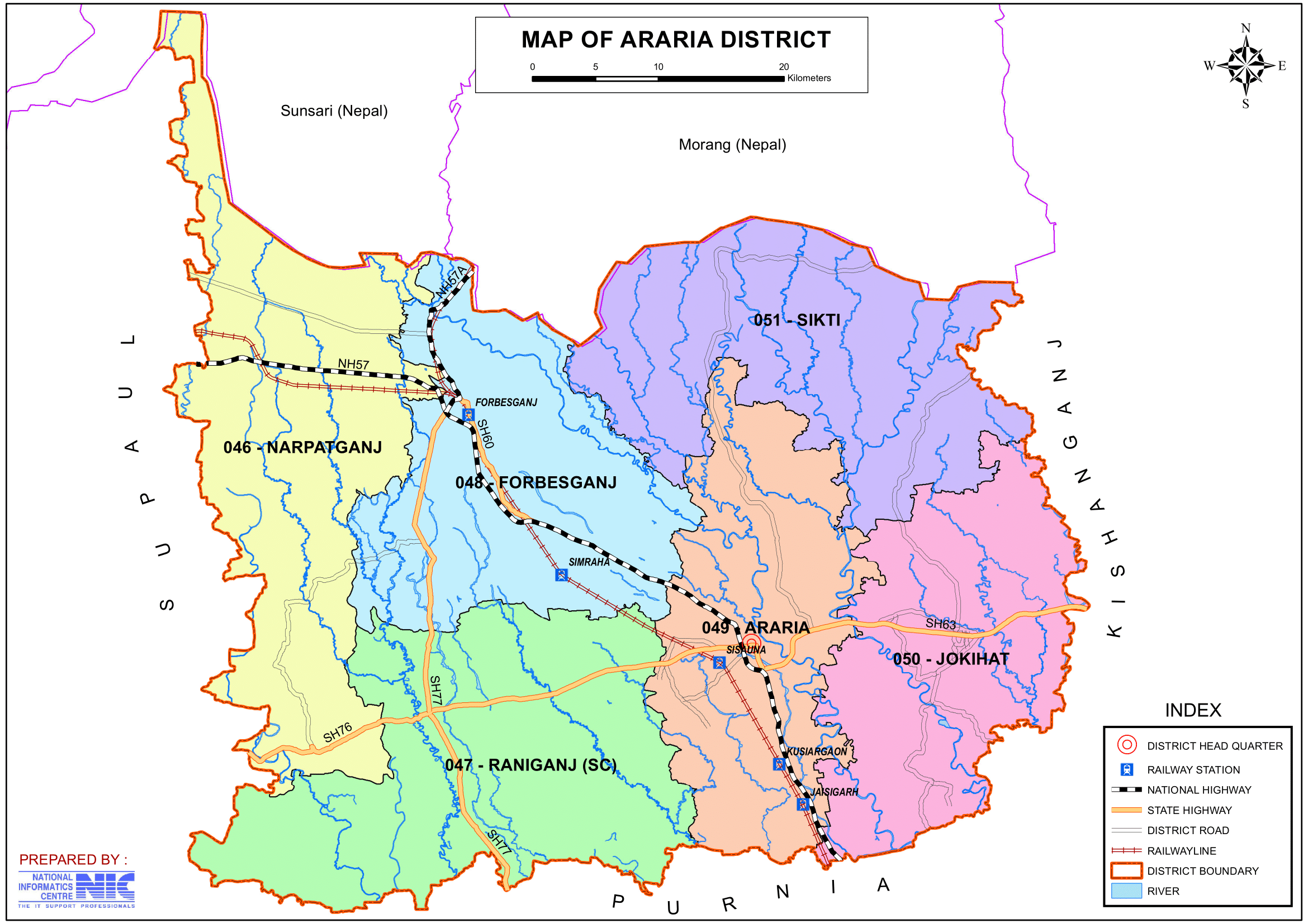
- No. of Subdivision: 2 (Araria, Forbesganj)
- No. of Blocks: 9
- Araria- Araria, Jokihat, Kursakanta, Raniganj, Sikti, Palasi.
- Forbesganj- Forbesganj, Narpatganj, Bhargama.
- Police Station: 26
- Tarabari, Jokihat, Palasi, Sikti, Bardaha, Forbesganj, Jogbani, Kursakanta, Raniganj, Baunsi, Bhargama, Narpatganj, Phulkaha, Araria, SC/ST PS, Women PS (OP- Madanpur, Bairgachi, Araria RS, Mahalgaon, Simraha, Ghurna, Sonamani Gudam, Kuar, Basmatiya, Bathnaha)
- Municipal Council (Nagar Parishad): 2 (Araria, Forbesganj)
- Nagar Panchayat: 1 (Jogbani)
- Lok Sabha constituency: 1 (Araria)
- Vidhan Sabha constituencies: 6
- 46- Narpatganj, 47- Raniganj, 48- Forbesganj, 49- Araria, 50- Jokihat, 51- Sikti
- Key Features:
- Located near the Indo-Nepal border, making it significant for trade and commerce.
- A predominantly rural district with an agrarian economy.
- Rich in cultural diversity and traditional practices.
- Significance: A district of strategic and agricultural importance.
- Notable People:
- Phanishwar Nath ‘Renu’, novelist and story writer.
- Mohammed Taslimuddin Former Union Minister of State
- Subrata Roy, chairman of Sahara Group
- Quaiser Khalid IPS, Maharashtra Cadre, Poet, Educationist
- Postal Address: Head Post Office Araria, Near Chandani Chowk, Araria- 854311, Phone: 06453-222199
- Time Zone: UTC+05:30 (IST)
- Human Development Index (HDI): 0.251 (low)
- Major Highways: NH-57
- STD Code:
- Araria, Jokihat, Kursakanta, Sikti, Palasi: 06453
- Forbesganj, Narpatganj: 06455
- Raniganj, Bhargama: 06461
- PIN Code: 854311 (Araria)
- Official Website: araria.nic.in
Geography
- Location: Araria is situated in northeastern Bihar, sharing its northern border with Nepal. It is bordered by Supaul to the west, Kishanganj to the east, and Purnia to the south.
- Area: The district covers an area of approximately 2,830 square kilometers.
- The district has a view of Mount Kanchenjunga (One of the great peaks of the Himalyan range).
- Rivers: Araria is traversed by rivers such as the Kosi, Suwara, Kali, Parmar, Koli and Panaar, which contribute to the fertility of the land but also cause frequent floods.
- Climate: The district experiences a humid subtropical climate with hot summers, heavy monsoons, and mild winters.
History
- Formation: Araria was carved out of the Purnia district and established as a separate district on 14 January 1990.
- Historical Significance: The name “Araria” is believed to have originated from the term “Resaldar Nagar,” as the area served as the headquarters of a British cavalry regiment during colonial times. Over time, it evolved to Araria.
- Another name for Araria is “Renu ki Dharti” (The Land of Renu). His work, after Munshi Prem Chand, was among the most significant in modern Hindi literature.
- Cultural Heritage: The district has strong ties to Mithila’s cultural and literary traditions.
Demographics (According to the 2011 Census)
- Population:
- Total Population: Araria district has a population of 2,811,569 (approximately 2.81 million), comparable to the nation of Jamaica or the US state of Utah.
- Ranking: 139th in India (out of 640 districts).
- Population Density: 992 inhabitants per square kilometer (2,570/sq mi).
- Population Growth (2001–2011): 30% reflecting significant population increase.
- Sex Ratio: 921 females per 1,000 males, indicating a gender disparity.
- Literacy Rate: The literacy rate is 53.53%, with significant disparities between urban and rural areas, and efforts ongoing to improve educational access in rural areas.
- Urban Population: 6.00% of the total population lives in urban areas.
- Religious Composition (2011 Census):
- Hinduism: 56.68%
- Scheduled Castes: 13.61%
- Scheduled Tribes: 1.38%
- Islam: 42.95%
- Other or not stated: 0.37%
- Hinduism: 56.68%
- Languages: The primary languages spoken are Maithili, Hindi, Urdu, Kulhaiya, Surjapuri, Santali and Bengali, reflecting the district’s linguistic diversity.
- Urdu: 28.71%
- Hindi: 25.05%
- Maithili (including Thati): 20.57%
- Other languages (recorded under Hindi): 16.43%
- Bengali: 2.17%
- Kulhaiya: 2.10%
- Surjapuri: 1.91%
- Santali: 1.05%
- Others: 2.01%
Administration
- Headquarters: Araria town serves as the district headquarters.
- Subdivisions:
- The district is divided into two subdivisions: Araria Sadar and Forbesganj, which are further divided into blocks for better governance.
- Each subdivision is led by a subdivisional magistrate who is in charge of development, revenue-related tasks, and maintaining law and order.
- Blocks and Circles:
- Araria district is divided into 9 Blocks and Circles.
- Araria- Araria, Jokihat, Kursakanta, Raniganj, Sikti, Palasi.
- Forbesganj- Forbesganj, Narpatganj, Bhargama.
- A circle officer (CO) leads each circle, while a Block Development Officer (BDO) leads each block.
- Araria district is divided into 9 Blocks and Circles.
- Governance: Araria is part of the Purnia division and has representation in both the Bihar Legislative Assembly and the Indian Parliament.
- Lok Sabha constituency: Araria
- Vidhan Sabha constituencies: 6
- 46- Narpatganj, 47- Raniganj, 48- Forbesganj, 49- Araria, 50- Jokihat, 51- Sikti
Organisation Chart

Economy
- Agriculture: The economy of Araria is predominantly agrarian, with major crops including rice, wheat, paddy, maize, jute, and pulses. The fertile alluvial soil supports high agricultural productivity.
- Trade and Border Economy: Araria’s location near the Nepal border makes it a key trade hub for cross-border commerce.
- Small-scale Industries: Jute production, agro-processing, and small-scale industries contribute to the local economy.
- Employment: Despite its agricultural strength, the district faces high unemployment, leading to migration to other states for better opportunities.
- Backward District Status: In 2006, the Indian government identified Araria as one of the 250 most backward districts in the country (out of 640).
- Aspirational District: Despite its challenges, Araria has been included in the list of 112 aspirational districts of India by NITI Aayog for targeted developmental efforts.
- Funding and Development: Araria is one of the 36 districts in Bihar currently receiving financial support through the Backward Regions Grant Fund Programme (BRGF) to address its socio-economic disparities and promote growth.
Education
Araria has a growing educational infrastructure, though rural areas still face challenges in access and quality:
- Schools and Colleges: Government and private schools, along with several colleges affiliated with BN Mandal University, cater to students in the region.
- Arara College Araria
- Forbesganj College Forbesganj
- Technical Education: Institutions providing vocational and technical education are gradually being established to address the district’s skill development needs.
- MBIT an International Engineering College
Culture
- Festivals: Araria celebrates festivals like Chhath Puja, Durga Puja, Eid, and Holi with great enthusiasm, reflecting its diverse religious and cultural heritage.
- Cuisine: The cuisine of Araria is deeply rooted in Maithili traditions, featuring dishes like litti chokha, dal-pitha, and sweets like khaja and balushahi.
- Art and Music: Araria district contributes to the Mithila region’s cultural richness through its folk songs, dances, and Maithili art forms.
- Gangetic Dolphins:
- Araria district serves as a natural habitat for the Gangetic Dolphins (South Asian river dolphins), scientifically known as Platanista gangetica. These dolphins are commonly found in the local rivers of the district. With an average length of about 2.5 meters, the Gangetic Dolphin holds ecological importance and is considered an indicator of the health of the river ecosystem. These freshwater dolphins are a unique and treasured part of Araria’s biodiversity.
Tourism
Araria district has several places of historical, religious, and natural importance:
- Jogbani: A town near the India-Nepal border, serving as a trade point and an attraction for its bustling markets.
- Shakti Peeth Mandir: A revered temple dedicated to Goddess Durga, attracting devotees from nearby regions.
- “Kali Mandir” is the common name for the six-story Kali Mandir temple.
- Maata aasawar mandir in Gidwas is very important for Hindu.
- Shiv Temple: The Temple of Lord Shiva, situated in the heart of Araria city, is a prominent spiritual and cultural landmark. Located within the ancient Thakurbari, it is widely referred to as Shiva Mandir or simply Thakurbari by the locals. This revered temple attracts devotees year-round and is known for its historical and religious significance in the region.
- As well as Shiv temple Of Madanpur and Sundernath are also famous.
- Kosi River: The scenic beauty of the Kosi River and its surroundings provide opportunities for nature lovers and visitors.
- Shrines and Mosques: The district has various religious sites, reflecting its cultural and religious diversity.
- Quba Masjid, is situated near navratan chowk. It is one of the famous mosque of this city.
- Sultan phokher in Forbesganj is important for Hindu and Muslim communities.
- Replica Stoop: It is situated Near Manikpur about 15 km far from Araria district headquarter going towards Forbesganj.
Raniganj Vriksh Vatika:
- Location:
- 30 km west of Araria District Headquarters, Bihar.
- 25 km east of S.H. 77.
- 310 km northeast of Patna, near Forbesganj (NH 57) to South Kursela.
- Historical Background:
- Previously known as Hasanpur Balu Dhima.
- Declared as forest land by the Bihar government.
- Area and Development:
- Covers 289 acres of land.
- Transformed into a natural forest area with an attractive landscape to meet tourist needs.
- Significance:
- Tourist Attraction: A scenic and picturesque destination in Bihar.
- Nature and Health: Ideal for nature lovers and health enthusiasts.
- Research: Serves as a valuable site for researchers.
- Current Appeal: Offers a blend of natural beauty and a serene environment for visitors.
Bihar’s First Biodiversity
- Significance:
- Recognized as Bihar’s first biodiversity park, fostering environmental awareness.
- Creates opportunities for researchers to study biodiversity.
- Tourism Promotion:
- Attracts visitors from far-off places due to its proximity to NH-57.
- Serves as a major tourist destination for nature enthusiasts and locals alike.
- Location:
- Situated in Kusiargaon, just 10 km from Araria District Headquarters.
- Impact:
- Contributes to the preservation of biodiversity in the region.
- Enhances eco-tourism and boosts local economy through tourism activities.
- Accessibility: Strategically located near the national highway, making it easy to access for travelers.
Transportation
- Railways: Araria is connected by the Indian Railways network, with Araria Court and Forbesganj being major railway stations in the district.
- The East-West Corridor runs through the area. The area has two railway stations and trains run on wide gauge tracks. This route finishes on one side at the Katihar Junction, a large and significant junction from which trains to all around India depart; on the other end of the track lies Jogbani, India’s final rail station.
- Roadways: Araria district has good road connectivity through National Highways like NH-57, linking it to major towns and cities.
- Airport: The nearest airports are Bagdogra Airport in West Bengal (about 160 km) and Darbhanga Airport (about 175 km).
Challenges
- Flooding: Frequent flooding due to the Kosi River disrupts agriculture, infrastructure, and livelihoods.
- Infrastructure: Araria district faces challenges in healthcare, education, and transportation, particularly in rural areas.
- Unemployment: Limited industrial growth and employment opportunities lead to high migration rates.
Conclusion
Araria is a district of strategic and cultural importance, serving as a vital trade hub due to its location near the Nepal border. With fertile lands, rich traditions, and a hardworking population, Araria holds immense potential for development. Addressing challenges like floods, infrastructure gaps, and unemployment through focused government initiatives can pave the way for the district’s progress and prosperity.
Would you like more details about any specific Topics on Bihar? Comment Below
अररिया जिला: समृद्ध विरासत और विकास की विशेष कहानियाँ
अवलोकन
अररिया जिला भारत के बिहार के पूर्वोत्तर भाग में स्थित 38वें जिलों में से एक है। अपनी ऐतिहासिक जड़ों, कृषि अर्थव्यवस्था और नेपाल सीमा से निकटता के लिए जाना जाने वाला यह जिला फोर्ब्सगंज मुख्यालय से केवल 8 किमी दूर है। सांस्कृतिक रूप से समृद्ध मिथिला क्षेत्र का हिस्सा, अररिया एक व्यापार केंद्र के रूप में रणनीतिक महत्व रखता है और परंपराओं, भाषाओं और समुदायों के विविध मिश्रण को प्रदर्शित करता है। यह जिला 2,830 km2 (1,090 वर्ग मील) के क्षेत्र में फैला हुआ है। अररिया की स्थापना 14 जनवरी 1990 को पूर्णिया डिवीजन के तहत एक जिले के रूप में की गई थी। जिले का प्रशासनिक केंद्र अररिया शहर में स्थित है।
प्राचीन युग
अनिश्चितता के बावजूद, अररिया का अतीत बहुत ही शानदार रहा है। जिले के प्राचीन इतिहास के महत्वपूर्ण विवरण महाभारत के सभा पर्व और वन पर्व में पाए जा सकते हैं, जो पूर्वी भारत में भीम की विजय का वर्णन करते हैं।
वैदिक काल के उत्तरार्ध (लगभग 1100-500 ईसा पूर्व) से ही अररिया जिला मिथिलांचल (मिथिला क्षेत्र) का हिस्सा रहा है। मिथिला को सबसे पहले तब प्रसिद्धि मिली जब इंडो-आर्यन वहां चले गए और मिथिला साम्राज्य की स्थापना की, जिसे विदेहों का साम्राज्य भी कहा जाता है। विदेह, कुरु और पंचाल दक्षिण एशिया के संस्कृति और राजनीति के प्रमुख केंद्रों के रूप में उभरे। विदेह साम्राज्य के शासकों को जनक के नाम से जाना जाता था। विदेह साम्राज्य को अंततः वज्जि संघ में एकीकृत कर दिया गया, जिसकी राजधानी वैशाली में थी, जो मिथिला में ही स्थित है।
अररिया, जो पहले भारतीय इतिहास में तीन महत्वपूर्ण कुलों द्वारा शासित था, को एक ऐसे स्थान के रूप में वर्णित किया जा सकता है जहाँ तीन पूरी तरह से अलग-अलग संस्कृतियाँ एक साथ आईं। पूर्वी भाग पर पुंड्राओं का शासन था और कोसी नदी के पश्चिम का क्षेत्र, जो उस समय आधुनिक अररिया के करीब बहती थी, अंगस द्वारा शासित था, जबकि उत्तरी भाग पर किरातों की महत्वपूर्ण जनजाति का शासन था।
ब्रिटिश काल
एलेग्जेंडर जॉन फोर्ब्स (1807-1890), ईस्ट इंडिया कंपनी के लिए एक ब्रिटिश जिला कलेक्टर और नगर आयुक्त, ब्रिटिश राज के तहत इस क्षेत्र का प्रशासन करते थे। वह एक सैन्य साहसी व्यक्ति थे जिन्होंने उत्तर-पश्चिम भारत के साहसिक कार्यों में भाग लिया था। 73वीं स्थानीय पैदल सेना के विद्रोहियों से लड़ते हुए, वह भागलपुर से कमिश्नर यूल के दस्ते के सदस्य भी थे। सुल्तानपुर एस्टेट की स्थापना अलेक्जेंडर जॉन फोर्ब्स ने की थी, जिन्होंने इस क्षेत्र में फैले अन्य नील कारखानों की भी स्थापना की थी। लोगों ने उस क्षेत्र का नाम छोटा कर दिया जहाँ श्री फोर्ब्स का घर स्थित था, जिसे “आवासीय क्षेत्र” या आर-क्षेत्र कहा जाता है। समय के साथ, नाम बदलकर ‘अररिया’ हो गया और उन्हें फोर्ब्सगंज उप-विभागीय शहर के नाम से सम्मानित किया जाता है।
1857 में स्वतंत्रता के पहले युद्ध के दौरान, अररिया ने नाथपुर के पास विद्रोहियों और कमिश्नर यूल के आदमियों के बीच कुछ झड़पें देखीं। 1857 की घटना और कानून-व्यवस्था में अन्य विकासों के मद्देनजर, बेहतर प्रशासन प्रदान करने के लिए अररिया, मटियारी, डिमिया, हवेली के कुछ हिस्सों और बहादुरगंज के छोटे डिवीजनों को मिलाकर 1864 में अररिया को एक उप-डिवीजन के रूप में स्थापित किया गया था, और अंततः 14 जनवरी 1990 को पूर्णिया डिवीजन के तहत बिहार के प्रशासनिक जिलों में से एक के रूप में इसका गठन किया गया।
अररिया जिले के बारे में मुख्य तथ्य
- देश: भारत
- राज्य: बिहार
- क्षेत्र: मिथिला
- विभाग: पूर्णिया
- निर्देशांक: 26°07′48″N 87°28′12″E
- स्थापना: 14 जनवरी 1990
- क्षेत्रफल: 2,830 km2 (1,090 वर्ग मील)
- जिला मुख्यालय: अररिया
- जिला मजिस्ट्रेट (DM): श्री अनिल कुमार, IAS
- पुलिस अधीक्षक (SP): श्री अंजनी कुमार, IPS
- जनसंख्या (2011):
- कुल: 2,811,569
- घनत्व: 990/km2 (2,600/वर्ग मील)
- साक्षरता दर: 53.53%
- लिंग अनुपात: 1000 पुरुषों पर 921 महिलाएं
- ग्राम पंचायत: 218
- गांव: 751 (लगभग)
- अनुमंडल की संख्या: 2 (अररिया, फारबिसगंज)
- ब्लॉकों की संख्या: 9
- अररिया- अररिया, जोकीहाट, कुर्साकांटा, रानीगंज, सिकटी, पलासी
- फारबिसगंज- फारबिसगंज, नरपतगंज, भरगामा
- पुलिस स्टेशन: 26
- ताराबाड़ी, जोकीहाट, पलासी, सिकटी, बरदाहा, फारबिसगंज, जोगबनी, कुर्साकांटा, रानीगंज, बौंसी, भरगामा, नरपतगंज, फुलकाहा, अररिया, एससी/एसटी थाना, महिला थाना (ओपी- मदनपुर, बैरगाछी, अररिया आरएस, महलगांव, सिमराहा, घुरना, सोनामनी गुदाम, कुआर, बसमतिया, बथनाहा)
- नगर परिषद: 2 (अररिया, फारबिसगंज)
- नगर पंचायत: 1 (जोगबनी)
- लोकसभा क्षेत्र: 1 (अररिया)
- विधान सभा क्षेत्र: 6
- 46- नरपतगंज, 47- रानीगंज, 48- फारबिसगंज, 49- अररिया, 50- जोकीहाट, 51- सिकटी
- प्रमुख विशेषताऐं:
- भारत-नेपाल सीमा के पास स्थित होने के कारण यह व्यापार के लिए महत्वपूर्ण है वाणिज्य।
- कृषि अर्थव्यवस्था वाला मुख्य रूप से ग्रामीण जिला।
- सांस्कृतिक विविधता और पारंपरिक प्रथाओं में समृद्ध।
- महत्व: सामरिक और कृषि महत्व का जिला।
- उल्लेखनीय लोग:
- फणीश्वर नाथ ‘रेणु’, उपन्यासकार और कहानीकार।
- मोहम्मद तस्लीमुद्दीन पूर्व केंद्रीय राज्य मंत्री
- सहारा समूह के अध्यक्ष सुब्रत रॉय
- कैसर खालिद आईपीएस, महाराष्ट्र कैडर, कवि, शिक्षाविद्
- डाक पता: डाकघर अररिया, चांदनी चौक के पास, अररिया- 854311, फ़ोन: 06453-222199
- मानव विकास सूचकांक (HDI): 0.251 (कम)
- समय क्षेत्र: UTC+05:30 (IST)
- प्रमुख राजमार्ग: NH-57
- एसटीडी कोड:
- अररिया, जोकीहाट, कुर्साकांटा, सिकटी, पलासी: 06453
- फारबिसगंज, नरपतगंज: 06455
- रानीगंज, भरगामा: 06461
- पिन कोड: 854311 (अररिया)
- आधिकारिक वेबसाइट: araria.nic.in
भूगोल
- स्थान: अररिया बिहार के उत्तर-पूर्वी भाग में स्थित है, जिसकी उत्तरी सीमा नेपाल से लगती है। इसकी सीमा पश्चिम में सुपौल, पूर्व में किशनगंज और दक्षिण में पूर्णिया से लगती है।
- क्षेत्र: यह जिला लगभग 2,830 वर्ग किलोमीटर में फैला हुआ है।
- जिले से कंचनजंगा पर्वत (हिमालय पर्वतमाला की सबसे बड़ी चोटियों में से एक) का नज़ारा दिखता है।
- नदियाँ: अररिया में कोसी, सुवारा, काली, परमार, कोली और पनार जैसी नदियाँ बहती हैं, जो भूमि की उर्वरता में योगदान देती हैं, लेकिन अक्सर बाढ़ का कारण भी बनती हैं।
- जलवायु: जिले में गर्म ग्रीष्मकाल, भारी मानसून और हल्की सर्दियाँ के साथ आर्द्र उपोष्णकटिबंधीय जलवायु होती है।
इतिहास
- गठन: अररिया को पूर्णिया जिले से अलग करके 14 जनवरी 1990 को एक अलग जिले के रूप में स्थापित किया गया था।
- ऐतिहासिक महत्व: माना जाता है कि “अररिया” नाम “रिसालदार नगर” शब्द से उत्पन्न हुआ है, क्योंकि यह क्षेत्र औपनिवेशिक काल के दौरान ब्रिटिश घुड़सवार सेना रेजिमेंट के मुख्यालय के रूप में कार्य करता था। समय के साथ, यह अररिया बन गया।
- अररिया का दूसरा नाम “रेणु की धरती” (रेणु की भूमि) है। मुंशी प्रेम चंद के बाद उनकी रचनाएँ आधुनिक हिंदी साहित्य में सबसे महत्वपूर्ण थीं।
- सांस्कृतिक विरासत: जिले का मिथिला की सांस्कृतिक और साहित्यिक परंपराओं से गहरा संबंध है।
जनसांख्यिकी (2011 की जनगणना के अनुसार)
- जनसंख्या:
- कुल जनसंख्या: पूर्णिया जिले की जनसंख्या 2,811,569 (लगभग 2.81 मिलियन) है, जो जमैका राष्ट्र या यूटा के अमेरिकी राज्य के बराबर है।
- रैंकिंग: भारत में 139वीं (640 जिलों में से)।
- जनसंख्या घनत्व: प्रति वर्ग किलोमीटर 992 निवासी (2,570/वर्ग मील)।
- जनसंख्या वृद्धि (2001-2011): 30%, जो महत्वपूर्ण जनसंख्या वृद्धि को दर्शाता है।
- लिंग अनुपात: प्रति 1,000 पुरुषों पर 921 महिलाएँ, जो लैंगिक असमानता को दर्शाता है।
- साक्षरता दर: साक्षरता दर 53.53% है, जिसमें शहरी और ग्रामीण क्षेत्रों के बीच महत्वपूर्ण असमानताएँ हैं, और ग्रामीण क्षेत्रों में शिक्षा की पहुँच में सुधार के लिए प्रयास जारी हैं।
- शहरी जनसंख्या: कुल जनसंख्या का 6.00% शहरी क्षेत्रों में रहता है।
- धार्मिक संरचना (2011 की जनगणना):
- हिंदू धर्म: 56.68%
- अनुसूचित जाति: 13.61%
- अनुसूचित जनजाति: 1.38%
- इस्लाम: 42.95%
- अन्य या नहीं बताया गया: 0.37%
- हिंदू धर्म: 56.68%
- भाषाएँ: बोली जाने वाली मुख्य भाषाएँ मैथिली, हिंदी, उर्दू, कुल्हैया, सुरजापुरी, संथाली और बंगाली हैं, जो जिले की भाषाई विविधता को दर्शाती हैं।
- उर्दू: 28.71%
- हिंदी: 25.05%
- मैथिली (थाती सहित): 20.57%
- अन्य भाषाएँ (हिन्दी के अंतर्गत दर्ज): 16.43%
- बंगाली: 2.17%
- कुल्हैया: 2.10%
- सुरजापुरी: 1.91%
- संताली: 1.05%
- अन्य: 2.01%
प्रशासन
- मुख्यालय: अररिया शहर जिला मुख्यालय के रूप में कार्य करता है।
- उपखंड:
- जिले को दो उपखंडों में विभाजित किया गया है: अररिया सदर और फोर्ब्सगंज, जिन्हें बेहतर प्रशासन के लिए आगे ब्लॉकों में विभाजित किया गया है।
- प्रत्येक उपखंड का नेतृत्व एक उपखंड मजिस्ट्रेट करता है जो विकास, राजस्व संबंधी कार्यों और कानून व्यवस्था बनाए रखने का प्रभारी होता है।
- ब्लॉक और सर्किल:
- अररिया जिले को 9 ब्लॉक और सर्किल में विभाजित किया गया है।
- अररिया- अररिया, जोकीहाट, कुर्साकांटा, रानीगंज, सिकटी, पलासी
- फारबिसगंज- फारबिसगंज, नरपतगंज, भरगामा
- एक सर्किल अधिकारी (सीओ) प्रत्येक सर्किल का नेतृत्व करता है, जबकि एक ब्लॉक विकास अधिकारी (बीडीओ) प्रत्येक ब्लॉक का नेतृत्व करता है।
- अररिया जिले को 9 ब्लॉक और सर्किल में विभाजित किया गया है।
- शासन: अररिया पूर्णिया डिवीजन का हिस्सा है और बिहार विधानसभा और भारतीय संसद दोनों में इसका प्रतिनिधित्व है।
- लोकसभा क्षेत्र: अररिया
- विधान सभा क्षेत्र: 6
- 46- नरपतगंज, 47- रानीगंज, 48- फारबिसगंज, 49- अररिया, 50- जोकीहाट, 51- सिकटी
अर्थव्यवस्था
- कृषि: अररिया की अर्थव्यवस्था मुख्य रूप से कृषि आधारित है, जिसमें चावल, गेहूं, धान, मक्का, जूट और दालें शामिल हैं। उपजाऊ जलोढ़ मिट्टी उच्च कृषि उत्पादकता का समर्थन करती है।
- व्यापार और सीमा अर्थव्यवस्था: नेपाल सीमा के पास अररिया का स्थान इसे सीमा पार वाणिज्य के लिए एक प्रमुख व्यापार केंद्र बनाता है।
- लघु उद्योग: जूट उत्पादन, कृषि प्रसंस्करण और लघु उद्योग स्थानीय अर्थव्यवस्था में योगदान करते हैं।
- रोजगार: अपनी कृषि शक्ति के बावजूद, जिले में उच्च बेरोजगारी का सामना करना पड़ता है, जिससे बेहतर अवसरों के लिए अन्य राज्यों में पलायन होता है।
- पिछड़े जिले की स्थिति: 2006 में, भारत सरकार ने अररिया को देश के 250 सबसे पिछड़े जिलों (640 में से) में से एक के रूप में पहचाना।
- आकांक्षी जिला: अपनी चुनौतियों के बावजूद, अररिया को लक्षित विकासात्मक प्रयासों के लिए नीति आयोग द्वारा भारत के 112 आकांक्षी जिलों की सूची में शामिल किया गया है।
- वित्त पोषण और विकास: अररिया बिहार के उन 36 जिलों में से एक है, जिन्हें वर्तमान में पिछड़ा क्षेत्र अनुदान निधि कार्यक्रम (BRGF) के माध्यम से वित्तीय सहायता मिल रही है, ताकि इसकी सामाजिक-आर्थिक असमानताओं को दूर किया जा सके और विकास को बढ़ावा दिया जा सके।
शिक्षा
अररिया में शिक्षा का बुनियादी ढांचा बढ़ रहा है, हालांकि ग्रामीण इलाकों में अभी भी पहुंच और गुणवत्ता में चुनौतियों का सामना करना पड़ रहा है:
- स्कूल और कॉलेज: सरकारी और निजी स्कूल, साथ ही बीएन मंडल विश्वविद्यालय से संबद्ध कई कॉलेज, इस क्षेत्र के छात्रों को शिक्षा प्रदान करते हैं।
- अररिया कॉलेज, अररिया
- फारबिसगंज कॉलेज, फारबिसगंज
- तकनीकी शिक्षा: जिले की कौशल विकास आवश्यकताओं को पूरा करने के लिए व्यावसायिक और तकनीकी शिक्षा प्रदान करने वाले संस्थान धीरे-धीरे स्थापित किए जा रहे हैं।
- MBIT एक अंतर्राष्ट्रीय इंजीनियरिंग कॉलेज है
संस्कृति
- त्यौहार: अररिया छठ पूजा, दुर्गा पूजा, ईद और होली जैसे त्यौहारों को बड़े उत्साह के साथ मनाता है, जो इसकी विविध धार्मिक और सांस्कृतिक विरासत को दर्शाता है।
- भोजन: अररिया का भोजन मैथिली परंपराओं में गहराई से निहित है, जिसमें लिट्टी चोखा, दाल-पीठा और खाजा और बालूशाही जैसी मिठाइयाँ शामिल हैं।
- कला और संगीत: यह जिला अपने लोकगीतों, नृत्यों और मैथिली कला रूपों के माध्यम से मिथिला क्षेत्र की सांस्कृतिक समृद्धि में योगदान देता है।
- गंगा डॉल्फ़िन:
- अररिया गंगा डॉल्फ़िन (दक्षिण एशियाई नदी डॉल्फ़िन) के लिए एक प्राकृतिक आवास के रूप में कार्य करता है, जिसे वैज्ञानिक रूप से प्लैटनिस्टा गैंगेटिका के रूप में जाना जाता है। ये डॉल्फ़िन आमतौर पर जिले की स्थानीय नदियों में पाई जाती हैं। लगभग 2.5 मीटर की औसत लंबाई के साथ, गंगा डॉल्फ़िन पारिस्थितिक महत्व रखती है और इसे नदी पारिस्थितिकी तंत्र के स्वास्थ्य का संकेतक माना जाता है। ये मीठे पानी की डॉल्फ़िन अररिया की जैव विविधता का एक अनूठा और क़ीमती हिस्सा हैं।
पर्यटन
अररिया में ऐतिहासिक, धार्मिक और प्राकृतिक महत्व के कई स्थान हैं:
- जोगबनी: भारत-नेपाल सीमा के पास एक शहर, जो एक व्यापार बिंदु के रूप में कार्य करता है और अपने हलचल भरे बाजारों के लिए आकर्षण का केंद्र है।
- शक्ति पीठ मंदिर: देवी दुर्गा को समर्पित एक पूजनीय मंदिर, जो आस-पास के क्षेत्रों से भक्तों को आकर्षित करता है।
- “काली मंदिर” छह मंजिला काली मंदिर मंदिर का सामान्य नाम है।
- गिडवास में माता आसवर मंदिर हिंदुओं के लिए बहुत महत्वपूर्ण है।
- शिव मंदिर: अररिया शहर के मध्य में स्थित भगवान शिव का मंदिर एक प्रमुख आध्यात्मिक और सांस्कृतिक स्थल है। प्राचीन ठाकुरबाड़ी के भीतर स्थित, इसे स्थानीय लोग शिव मंदिर या केवल ठाकुरबाड़ी के रूप में संदर्भित करते हैं। यह पूजनीय मंदिर साल भर भक्तों को आकर्षित करता है और इस क्षेत्र में अपने ऐतिहासिक और धार्मिक महत्व के लिए जाना जाता है।
- साथ ही मदनपुर और सुंदरनाथ के शिव मंदिर भी प्रसिद्ध हैं।
- कोसी नदी: कोसी नदी और उसके आसपास की प्राकृतिक सुंदरता प्रकृति प्रेमियों और आगंतुकों के लिए अवसर प्रदान करती है।
- दरगाह और मस्जिदें: जिले में कई धार्मिक स्थल हैं, जो इसकी सांस्कृतिक और धार्मिक विविधता को दर्शाते हैं।
- क्यूबा मस्जिद, नवरतन चौक के पास स्थित है। यह इस शहर की प्रसिद्ध मस्जिदों में से एक है।
- फोर्ब्सगंज में सुल्तान फोखर हिंदू और मुस्लिम समुदायों के लिए महत्वपूर्ण है।
- प्रतिकृति स्तूप: यह अररिया जिला मुख्यालय से लगभग 15 किमी दूर फोर्ब्सगंज की ओर जाने वाले मानिकपुर के पास स्थित है।
रानीगंज वृक्ष वाटिका:
- स्थान:
- बिहार के अररिया जिला मुख्यालय से 30 किमी पश्चिम में।
- एस.एच. 77 से 25 किमी पूर्व में।
- पटना से 310 किमी उत्तर पूर्व में, फोर्ब्सगंज (एनएच 57) के पास दक्षिण कुरसेला तक।
- ऐतिहासिक पृष्ठभूमि:
- पहले हसनपुर बालू धीमा के नाम से जाना जाता था।
- बिहार सरकार द्वारा वन भूमि घोषित किया गया।
- क्षेत्र और विकास:
- 289 एकड़ भूमि को कवर करता है।
- पर्यटकों की जरूरतों को पूरा करने के लिए एक आकर्षक परिदृश्य के साथ एक प्राकृतिक वन क्षेत्र में परिवर्तित हो गया।
- महत्व:
- पर्यटक आकर्षण: बिहार में एक सुंदर और मनोरम स्थल।
- प्रकृति और स्वास्थ्य: प्रकृति प्रेमियों और स्वास्थ्य के प्रति उत्साही लोगों के लिए आदर्श।
- शोध: शोधकर्ताओं के लिए एक मूल्यवान स्थल के रूप में कार्य करता है।
- वर्तमान अपील: आगंतुकों के लिए प्राकृतिक सुंदरता और शांत वातावरण का मिश्रण प्रदान करता है।
अररिया के कुसियारगांव में बिहार का पहला जैव विविधता पार्क:
- महत्व:
- पर्यावरण जागरूकता को बढ़ावा देने वाले बिहार के पहले जैव विविधता पार्क के रूप में मान्यता प्राप्त है।
- शोधकर्ताओं के लिए जैव विविधता का अध्ययन करने के अवसर पैदा करता है।
- पर्यटन को बढ़ावा:
- एनएच-57 के निकट होने के कारण दूर-दूर से आगंतुकों को आकर्षित करता है।
- प्रकृति प्रेमियों और स्थानीय लोगों के लिए एक प्रमुख पर्यटन स्थल के रूप में कार्य करता है।
- स्थान:
- अररिया जिला मुख्यालय से सिर्फ 10 किमी दूर कुसियारगांव में स्थित है।
- प्रभाव:
- क्षेत्र में जैव विविधता के संरक्षण में योगदान देता है।
- पर्यटन गतिविधियों के माध्यम से इको-टूरिज्म को बढ़ाता है और स्थानीय अर्थव्यवस्था को बढ़ावा देता है।
- पहुँच: राष्ट्रीय राजमार्ग के निकट रणनीतिक रूप से स्थित होने के कारण यात्रियों के लिए यहाँ पहुँचना आसान है।
परिवहन
- रेलवे: अररिया भारतीय रेलवे नेटवर्क से जुड़ा हुआ है, अररिया कोर्ट और फोर्ब्सगंज जिले के प्रमुख रेलवे स्टेशन हैं।
- ईस्ट-वेस्ट कॉरिडोर इस क्षेत्र से होकर गुजरता है। इस क्षेत्र में दो रेलवे स्टेशन हैं और ट्रेनें वाइड गेज ट्रैक पर चलती हैं। यह मार्ग एक तरफ कटिहार जंक्शन पर समाप्त होता है, जो एक बड़ा और महत्वपूर्ण जंक्शन है जहाँ से पूरे भारत के लिए ट्रेनें निकलती हैं; ट्रैक के दूसरे छोर पर भारत का अंतिम रेलवे स्टेशन जोगबनी है।
- सड़क मार्ग: जिले में NH-57 जैसे राष्ट्रीय राजमार्गों के माध्यम से अच्छी सड़क कनेक्टिविटी है, जो इसे प्रमुख कस्बों और शहरों से जोड़ती है।
- हवाई अड्डा: निकटतम हवाई अड्डे पश्चिम बंगाल में बागडोगरा हवाई अड्डा (लगभग 160 किमी) और दरभंगा हवाई अड्डा (लगभग 175 किमी) हैं।
चुनौतियाँ
- बाढ़: कोसी नदी के कारण बार-बार आने वाली बाढ़ से कृषि, बुनियादी ढाँचा और आजीविका बाधित होती है।
- बुनियादी ढांचा: जिले को स्वास्थ्य सेवा, शिक्षा और परिवहन में चुनौतियों का सामना करना पड़ रहा है, खासकर ग्रामीण इलाकों में।
- बेरोजगारी: सीमित औद्योगिक विकास और रोजगार के अवसरों के कारण उच्च प्रवास दर होती है।
निष्कर्ष
अररिया रणनीतिक और सांस्कृतिक महत्व का जिला है, जो नेपाल सीमा के पास स्थित होने के कारण एक महत्वपूर्ण व्यापार केंद्र के रूप में कार्य करता है। उपजाऊ भूमि, समृद्ध परंपराओं और मेहनती आबादी के साथ, अररिया में विकास की अपार संभावनाएं हैं। केंद्रित सरकारी पहलों के माध्यम से बाढ़, बुनियादी ढांचे की कमी और बेरोजगारी जैसी चुनौतियों का समाधान करके जिले की प्रगति और समृद्धि का मार्ग प्रशस्त किया जा सकता है।
क्या आप बिहार के किसी विशेष विषय के बारे में अधिक जानकारी चाहते हैं? नीचे टिप्पणी करें 😊
पदानुक्रमिक संरचना: बिहार का विस्तृत रोडमैप
बिहार में प्रमंडल और उसके जिलों का विवरण
Important Links
𝕋𝕙𝕒𝕟𝕜 𝕐𝕠𝕦 𝔽𝕠𝕣 𝕍𝕚𝕤𝕚𝕥𝕚𝕟𝕘 𝕆𝕦𝕣 𝕎𝕖𝕓𝕤𝕚𝕥𝕖𝕤 🙂
6 thoughts on “Araria District: Special Stories of Rich Heritage and Growth”