
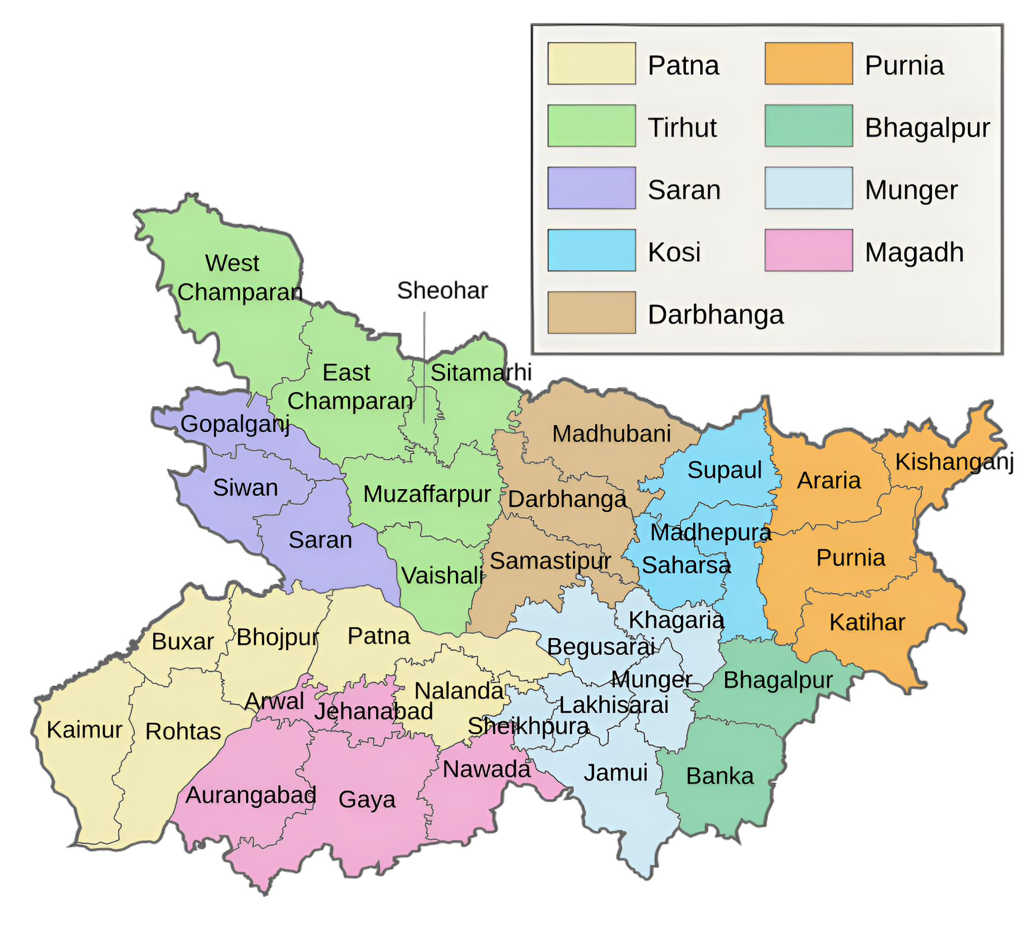
Bhagalpur Division: An Overview
Bhagalpur Division is one of the administrative divisions of Bihar, located in the southeastern part of the state, bordering Jharkhand to the south and west. It lies between 25° 07′ – 25° 30′ N latitude and 86° 37′ – 87° 30′ E longitude. The division is surrounded by Munger, Khagaria, Madhepura, Purnea, Katihar, and Banka districts of Bihar, as well as Godda and Sahebganj districts of Jharkhand. The division’s capital, Bhagalpur, is located on the Ganges River’s southern bank. It is the state’s oldest division, having been founded in 1765. Bhagalpur was once known as Champanagri, the capital of the Anga Kingdom.
The Vikramshila Gangetic Dolphin Sanctuary was created close to the town because the endangered Gangetic dolphin lives in the Ganges River, which flows through the division. With a rescue and rehabilitation facility at Bhagalpur, the division serves as a home for the larger adjutant stork as well.
City and Town:
The division’s capital, Bhagalpur, is located on the Ganges River’s southern bank. It is the state’s oldest division, having been founded in 1765. Bhagalpur was once known as Champanagri, the capital of the Anga Kingdom.
It is renowned for its cultural heritage, historical significance, and economic importance, particularly as a center of silk production. Known as the “Silk City” of India, Bhagalpur Division combines agricultural productivity with a growing industrial base.
One of three subdivisions of the Bhagalpur district of the Indian state of Bihar is the municipality town of Kahalgaon, which was once known as Colgong during British control. It is situated near Vikramashila.
The town and block of Sultanganj are located in Bihar’s Bhagalpur district. The distance from Bhagalpur is 25 kilometers.
The town of Banka serves as the administrative center for the Banka district in Bihar.
The Indian state of Bihar’s Bhagalpur district is home to the town of Navgachhia as well as a significant railway station. In addition to being a police district, it is a block and one of the three subdivisions of the Bhagalpur district.
Key Facts About Bhagalpur Division
- Country:
 India
India - State:
 Bihar
Bihar - Established: 1765
- Area: 5589 km2 (2162 sq mi)
- Population (2011): 5,061,565
- Coordinates: 25.25°N 87.0333°E
- Division Headquarters: Bhagalpur
- Divisional Commissioner: Dinesh Kumar
- No. of Blocks: 27
- Gram Panchyat: 424 (approx)
- Villages: 3515 (approx)
- Number of Districts: 2 (Bhagalpur, Banka)
- Subdivisions: 4 (Banka, Bhagalpur, Kahalgaon, Naugachhia)
- Rivers: Ganges
- Geography:
- Located in eastern Bihar along the Ganga River.
- Fertile plains, with significant agricultural and industrial activities.
- Transports:
- NH 31, NH 81
- Sahibganj loop
- Vikramshila Setu
- Lok Sabha constituencies: 2 (Banka, Bhagalpur)
- Vidhan Sabha constituencies: 12
- Bihpur, Gopalpur, Pirpainty(SC), Kahalgaon, Bhagalpur, Sultanganj, Nathnagar, Banka, Belhar, Amarpur, Katoria, Dhoraiya
- Power Station: Kahalgaon Super Thermal Power Station
- Official Website: bhagalpur.nic.in
Districts of Saran Division(Administrative Structure)
The Bhagalpur Division consists of two districts:
1. Bhagalpur District:
- Area: 2,569 km2 (992 sq mi)
- Population (2011): 3,037,766
- Literacy Rate: 63.14%
- District Headquarters: Bhagalpur
- Gram Panchayats: 242
- Villages: 1515
- No. of Subdivision: 3 (Naugachhia, Kahalgaon, Bhagalpur Sadar)
- Police Station: 41
- No. of Blocks: 16
- Goradih, Jagdishpur, Nathnagar, Sabour, Shahkund, Sultanganj, Kahalgaon, Pirpainty, Sanhaula, Bihpur, Gopalpur, Ismailpur, Kharik, Narayanpur, Naugachhiya, Rangrachowk
- Municipal Corporation(Nagar Nigam): 1 (Bhagalpur)
- Municipal Council ( Nagar Parishad): 1 (Sultanganj)
- Nagar Panchayat: 2 (Naugachia, Kahalgaon)
- Lok Sabha constituency: 2 (Bhagalpur, Banka)
- Vidhan Sabha constituencies: 7
- Bihpur, Gopalpur, Pirpainty(SC), Kahalgaon, Bhagalpur, Sultanganj, Nathnagar
- Key Features:
- Known as the “Silk City” due to its thriving silk industry, especially Tussar silk.
- Historically important as an ancient center of learning during the Vikramshila period.
- Tourist attractions include Vikramshila University ruins, Mandar Hill, and Ghantaghar.
- Significance: A center of trade, culture, and education.
- Official Website: bhagalpur.nic.in
2. Banka District:
- Area: 3,020 km2 (1,170 sq mi)
- Population (2011): 2,034,763
- Literacy Rate: 58.17%
- District Headquarters: Banka
- Gram Panchayats: 182
- Villages: 2000
- No. of Subdivision: 1 (Banka)
- Police Station: 23
- Banka, Belhar, Amarpur, Shambhuganj, Fullidumar, Katoria, Dhoraiya, Chandan, Panjwara, Baunsi, Barahat, Rajoun, Anandpur, Dhankund, Suiya, Jaipur, Khesar, Bhandhuakurawa, Nawada Bazar, Mahila P.S., S.C/S.T P.S., Traffic P.S., Cyber P.S.
- No. of Blocks: 11
- Banka, Belhar, Amarpur, Katoria, Dhoraiya, Shambhuganj, Fullidumar, Chandan, Barahat, Baunsi, Rajoun
- Municipal Council ( Nagar Parishad): 1 (Banka)
- Nagar Panchayat: 3 (Amarpur, Bounsi, Katoria)
- Lok Sabha constituency: 1 (Banka)
- Vidhan Sabha constituencies: 5 (Banka, Belhar, Amarpur, Katoria, Dhoraiya)
- Key Features:
- Known for its religious significance, including Mandar Hill, associated with Hindu and Jain mythology.
- A primarily agricultural district producing rice, wheat, and pulses.
- Rich in natural resources, including limestone and granite.
- Significance: A blend of spirituality and natural beauty.
- Official Website: banka.nic.in
Each district has its unique historical, cultural, and economic contributions to the division.
Geographical Overview
- Location: Bhagalpur Division is situated in southeastern Bihar, bordered by the Ganga River to the north and Jharkhand to the south.
- Rivers: The Ganga River flows prominently through the region, along with tributaries such as the Kosi and Chandan Rivers, supporting agriculture and local livelihoods.
- Topography: The region consists of fertile Gangetic plains in the north and hilly terrain toward the southern edges.
- Climate: The division experiences a humid subtropical climate with hot summers, monsoon rains, and mild winters.
Historical Significance
- Ancient Era: Bhagalpur has ancient roots, being part of the Anga Mahajanapada mentioned in early Indian texts. It was a significant center for trade and learning during the Magadha Empire.
- Medieval Period: During the medieval period, Bhagalpur was a thriving trade hub under the Delhi Sultanate and later the Mughals. Its silk industry gained prominence during this era.
- British Era: Under British rule, the division gained importance as an administrative and commercial center, particularly for the silk and jute industries. The development of railways and trade routes further enhanced its significance.
- Modern History: Bhagalpur Division played a role in India’s independence movement, with active participation in protests and revolutionary activities.
Cultural Significance
- Anga Region: Bhagalpur Division is historically associated with the ancient Anga region, which has a rich cultural and mythological legacy.
- Languages: Commonly spoken languages include Hindi, Angika, Maithili, and Bhojpuri.
- Festivals: Festivals such as Durga Puja, Chhath Puja, Makar Sankranti, and Sawan Mela are celebrated with enthusiasm.
- Silk Weaving: The division is famous for its traditional silk weaving art, particularly Tussar Silk and Bhagalpuri Sarees, which are internationally recognized.
Economy
- Agriculture: Agriculture is the backbone of the division’s economy, with rice, wheat, maize, and pulses being major crops. The Ganga River provides fertile soil for farming.
- Silk Industry: Bhagalpur is known as the “Silk City of India” for its centuries-old silk industry, which produces high-quality silk fabric exported worldwide.
- Minerals and Resources: The districts of Banka and Jamui are rich in mineral resources, including mica and bauxite, with mining contributing to the local economy.
- Livelihood: Apart from agriculture and silk weaving, residents engage in trade, small-scale industries, and labor migration.
- Challenges: Despite its economic potential, the division faces challenges such as flooding, limited industrialization, and inadequate infrastructure.
Education and Institutions
- Key Institutions:
- Tilka Manjhi Bhagalpur University (TMBU): A leading higher education institution in the region, offering undergraduate and postgraduate programs.
- Bihar Agricultural University, Sabour: Specializing in agricultural research and education.
- Schools and Colleges: While Bhagalpur city has a good number of schools and colleges, rural areas still lack adequate educational infrastructure.
- Focus on Traditional Skills: Efforts are being made to promote vocational training, particularly in silk weaving and textile technology.
Transportation and Connectivity
- Railways: Bhagalpur is a major railway junction, connecting the division to cities like Patna, Kolkata, and Delhi.
- Roadways: National Highways such as NH-31 and NH-80 pass through the region, providing good connectivity. However, rural road networks need improvement.
- Airways: Bhagalpur is served by a small airstrip, but commercial air travelers use the nearest airports in Patna or Kolkata.
- Waterways: The Ganga River has potential for water transport, although it remains underutilized.
Tourism
Bhagalpur Division offers a mix of natural beauty, historical landmarks, and cultural attractions:
- Vikramshila University (Bhagalpur): Ruins of the ancient Buddhist learning center, comparable to Nalanda, are a major attraction.
- Mandar Hill (Banka): A mythological site associated with the Samudra Manthan (Churning of the Ocean) in Hindu scriptures.
- Ajgaibinath Temple (Sultanganj): A significant religious site for Shiva devotees, especially during the Shravan Mela.
- Kuppaghat Ashram (Bhagalpur): A spiritual and meditation center on the banks of the Ganga River.
- Bhagalpuri Silk Market: A hub for silk enthusiasts to explore and buy traditional silk fabrics.
Challenges
- Flooding: The Ganga and Kosi rivers cause frequent flooding, displacing people and damaging crops and infrastructure.
- Infrastructure Deficiency: Rural areas face issues with roads, healthcare, and education.
- Industrial Development: Despite its silk industry, large-scale industrial development has been limited, leading to outmigration for employment.
- Environmental Concerns: Over-mining in Banka and Jamui districts and river pollution are growing issues.
Development Initiatives
- Flood Control Projects: Efforts are underway to improve embankments and flood management systems.
- Silk Industry Promotion: Government and private initiatives aim to modernize the silk weaving industry and provide better market access.
- Education and Skill Development: Programs to improve literacy rates and vocational training, especially in rural areas.
- Infrastructure Projects: Upgrading highways, railways, and urban infrastructure in Bhagalpur and surrounding areas.
Key Highlights
- Silk City: Bhagalpur is internationally renowned for its silk industry, with Bhagalpuri Sarees being a key export product.
- Ancient Heritage: The ruins of Vikramshila University and other historical landmarks highlight the division’s rich history.
- Religious Importance: Temples and pilgrimage sites attract devotees from across the country.
- Natural Resources: Fertile plains, mineral wealth, and proximity to the Ganga River make the division economically significant.
Conclusion
Bhagalpur Division is a region of immense historical, cultural, and economic importance in Bihar. Known for its rich silk heritage and agricultural productivity, the division also has significant potential for tourism and industrial growth. Addressing challenges like flooding, infrastructure gaps, and environmental concerns can unlock its full potential, enabling Bhagalpur Division to play a greater role in Bihar’s overall development.
Would you like more details about any specific Topics on Bihar? Comment Below
भागलपुर प्रमंडल: एक अवलोकन
भागलपुर प्रमंडल बिहार के प्रशासनिक प्रमंडलों में से एक है, जो राज्य के दक्षिण-पूर्वी भाग में स्थित है, दक्षिण और पश्चिम में झारखंड की सीमा से लगा हुआ है। यह 25° 07′ – 25° 30′ उत्तरी अक्षांश और 86° 37′ – 87° 30′ पूर्वी देशांतर के बीच स्थित है। यह प्रमंडल बिहार के मुंगेर, खगड़िया, मधेपुरा, पूर्णिया, कटिहार और बांका जिलों के साथ-साथ झारखंड के गोड्डा और साहेबगंज जिलों से घिरा हुआ है। प्रमंडल की राजधानी भागलपुर गंगा नदी के दक्षिणी तट पर स्थित है। यह राज्य का सबसे पुराना प्रमंडल है, जिसकी स्थापना 1765 में हुई थी। भागलपुर को कभी चंपानगरी के नाम से जाना जाता था, जो अंगा साम्राज्य की राजधानी थी।
विक्रमशिला गंगा डॉल्फिन अभयारण्य शहर के करीब बनाया गया था क्योंकि लुप्तप्राय गंगा डॉल्फिन गंगा नदी में रहती है, जो प्रमंडल से होकर बहती है। भागलपुर में बचाव और पुनर्वास सुविधा के साथ, यह प्रभाग बड़े सहायक सारस के लिए भी घर के रूप में कार्य करता है।
शहर और कस्बा:
इस प्रभाग की राजधानी भागलपुर गंगा नदी के दक्षिणी तट पर स्थित है। यह राज्य का सबसे पुराना प्रभाग है, जिसकी स्थापना 1765 में हुई थी। भागलपुर को कभी चंपानगरी के नाम से जाना जाता था, जो अंगा साम्राज्य की राजधानी थी।
यह अपनी सांस्कृतिक विरासत, ऐतिहासिक महत्व और आर्थिक महत्व के लिए प्रसिद्ध है, विशेष रूप से रेशम उत्पादन के केंद्र के रूप में। भारत के “रेशम शहर” के रूप में जाना जाने वाला भागलपुर प्रभाग कृषि उत्पादकता को बढ़ते औद्योगिक आधार के साथ जोड़ता है।
भारतीय राज्य बिहार के भागलपुर जिले के तीन उपखंडों में से एक कहलगांव नगरपालिका शहर है, जिसे कभी ब्रिटिश नियंत्रण के दौरान कोलगोंग के नाम से जाना जाता था। यह विक्रमशिला के पास स्थित है।
सुल्तानगंज का शहर और ब्लॉक बिहार के भागलपुर जिले में स्थित है। भागलपुर से इसकी दूरी 25 किलोमीटर है।
बांका शहर बिहार में बांका जिले के प्रशासनिक केंद्र के रूप में कार्य करता है।
भारत के बिहार राज्य के भागलपुर जिले में नवगछिया शहर के साथ-साथ एक महत्वपूर्ण रेलवे स्टेशन भी है। पुलिस जिला होने के अलावा, यह एक ब्लॉक है और भागलपुर जिले के तीन उपखंडों में से एक है।
भागलपुर प्रमंडल के बारे में मुख्य तथ्य
- देश: भारत
- राज्य: बिहार
- स्थापना: 1765
- क्षेत्रफल: 5589 km2 (2162 वर्ग मील)
- जनसंख्या (2011): 5,061,565
- मंडल मुख्यालय: भागलपुर
- मंडल आयुक्त: दिनेश कुमार
- निर्देशांक: 25.25°N 87.0333°E
- उपविभाग: 4 (बांका, भागलपुर, कहलगांव, नौगछिया)
- ब्लॉक की संख्या: 27
- ग्राम पंचायत: 424 (लगभग)
- गांव: 3515 (लगभग)
- जिलों की संख्या: 2 (भागलपुर, बांका)
- नदियाँ: गंगा
- भूगोल:
- गंगा नदी के किनारे पूर्वी बिहार में स्थित है।
- उपजाऊ मैदान, महत्वपूर्ण कृषि और औद्योगिक गतिविधियों के साथ।
- परिवहन:
- एनएच 31, एनएच 81
- साहिबगंज लूप
- विक्रमशिला सेतु
- लोकसभा क्षेत्र: 2 (बांका, भागलपुर)
- विधान सभा क्षेत्र: 12
- बिहपुर, गोपालपुर, पीरपैंती (एससी), कहलगांव, भागलपुर, सुल्तानगंज, नाथनगर, बांका, बेलहर, अमरपुर, कटोरिया, धोरैया
- पावर स्टेशन: कहलगांव सुपर थर्मल पावर स्टेशन
- आधिकारिक वेबसाइट: bhagalpur.nic.in
सारण प्रमंडल के जिले (प्रशासनिक संरचना)
भागलपुर प्रमंडल में दो जिले शामिल हैं:
1.भागलपुर जिला:
- क्षेत्रफल: 2,569 वर्ग किमी (992 वर्ग मील)
- जनसंख्या (2011): 3,037,766
- साक्षरता दर: 63.14%
- जिला मुख्यालय: भागलपुर
- ग्राम पंचायतें: 242
- गाँव: 1515
- अनुमण्डल की संख्या: 3 (नौगछिया, कहलगांव, भागलपुर सदर)
- पुलिस स्टेशन: 41
- ब्लॉकों की संख्या: 16
- गोराडीह, जगदीशपुर, नाथनगर, सबौर, शाहकुंड, सुल्तानगंज, कहलगांव, पीरपैंती, सन्हौला, बिहपुर, गोपालपुर, इस्माइलपुर, खरीक, नारायणपुर, नौगछिया, रंगराचौक
- नगर निगम: 1 (भागलपुर)
- नगर परिषद: 1 (सुल्तानगंज)
- लोकसभा क्षेत्र: 2 (भागलपुर, बांका)
- नगर पंचायत: 2 (नौगछिया, कहलगांव)
- विधानसभा क्षेत्र: 7
- बिहपुर, गोपालपुर, पीरपैंती (एससी), कहलगांव, भागलपुर, सुल्तानगंज, नाथनगर
- मुख्य विशेषताएं:
- अपने समृद्ध रेशम उद्योग, विशेष रूप से टसर रेशम के कारण इसे “रेशम नगर” के रूप में जाना जाता है।
- ऐतिहासिक रूप से महत्वपूर्ण विक्रमशिला काल के दौरान शिक्षा के एक प्राचीन केंद्र के रूप में।
- पर्यटक आकर्षणों में विक्रमशिला विश्वविद्यालय के खंडहर, मंदार हिल और घंटाघर शामिल हैं।
- महत्व: व्यापार, संस्कृति और शिक्षा का केंद्र।
- आधिकारिक वेबसाइट: bhagalpur.nic.in
2. बांका जिला:
- क्षेत्रफल: 3,020 km2 (1,170 वर्ग मील)
- जनसंख्या (2011): 2,034,763
- साक्षरता दर: 58.17%
- जिला मुख्यालय: बांका
- ग्राम पंचायतें: 182
- गाँव: 2000
- अनुमण्डल की संख्या: 1 (बांका)
- पुलिस स्टेशन: 23
- बांका, बेलहर, अमरपुर, शंभूगंज, फुल्लीडुमर, कटोरिया, धोरैया, चांदन, पंजवारा, बौंसी, बाराहाट, रजौन, आनंदपुर, धनकुंड, सुईया, जयपुर, खेसर, भंडुआकुरावा, नवादा बाजार, महिला थाना, एस.सी/एसटी पी.एस., ट्रैफिक पी.एस., साइबर पी.एस.
- प्रखंडों की संख्या: 11
- बांका, बेलहर, अमरपुर, कटोरिया, धोरैया, शंभूगंज, फुल्लीडुमर, चांदन, बाराहाट, बौंसी, रजौन
- नगर परिषद: 1 (बांका)
- नगर पंचायत: 3 (अमरपुर, बौंसी, कटोरिया)
- लोक विधानसभा क्षेत्र: 1 (बांका)
- विधानसभा क्षेत्र: 5 (बांका, बेलहर, अमरपुर, कटोरिया, धोरैया)
- मुख्य विशेषताएं:
- हिंदू और जैन पौराणिक कथाओं से जुड़े मंदार हिल सहित अपने धार्मिक महत्व के लिए जाना जाता है।
- चावल का उत्पादन करने वाला मुख्य रूप से कृषि प्रधान जिला, गेहूं और दालें।
- चूना पत्थर और ग्रेनाइट सहित प्राकृतिक संसाधनों से समृद्ध।
- महत्व: आध्यात्मिकता और प्राकृतिक सुंदरता का मिश्रण।
- आधिकारिक वेबसाइट: banka.nic.in
प्रत्येक जिले का संभाग में अपना अनूठा ऐतिहासिक, सांस्कृतिक और आर्थिक योगदान है।
भौगोलिक अवलोकन
- स्थान: भागलपुर डिवीजन दक्षिण-पूर्वी बिहार में स्थित है, जिसकी सीमा उत्तर में गंगा नदी और दक्षिण में झारखंड से लगती है।
- नदियाँ: गंगा नदी इस क्षेत्र से होकर बहती है, साथ ही कोसी और चंदन जैसी सहायक नदियाँ भी बहती हैं, जो कृषि और स्थानीय आजीविका का समर्थन करती हैं।
- स्थलाकृति: इस क्षेत्र में उत्तर में उपजाऊ गंगा के मैदान और दक्षिणी किनारों की ओर पहाड़ी इलाके हैं।
- जलवायु: इस डिवीजन में गर्म ग्रीष्मकाल, मानसून की बारिश और हल्की सर्दियाँ के साथ आर्द्र उपोष्णकटिबंधीय जलवायु का अनुभव होता है।
ऐतिहासिक महत्व
- प्राचीन युग: भागलपुर की जड़ें प्राचीन हैं, जो प्रारंभिक भारतीय ग्रंथों में वर्णित अंग महाजनपद का हिस्सा है। यह मगध साम्राज्य के दौरान व्यापार और शिक्षा के लिए एक महत्वपूर्ण केंद्र था।
- मध्यकालीन काल: मध्यकालीन काल के दौरान, भागलपुर दिल्ली सल्तनत और बाद में मुगलों के अधीन एक संपन्न व्यापार केंद्र था। इस युग के दौरान इसके रेशम उद्योग को प्रमुखता मिली।
- ब्रिटिश काल: ब्रिटिश शासन के तहत, इस प्रभाग ने एक प्रशासनिक और वाणिज्यिक केंद्र के रूप में महत्व प्राप्त किया, विशेष रूप से रेशम और जूट उद्योगों के लिए। रेलवे और व्यापार मार्गों के विकास ने इसके महत्व को और बढ़ा दिया।
- आधुनिक इतिहास: भागलपुर डिवीजन ने भारत के स्वतंत्रता आंदोलन में एक भूमिका निभाई, जिसमें विरोध और क्रांतिकारी गतिविधियों में सक्रिय भागीदारी थी।
सांस्कृतिक महत्व
- अंग क्षेत्र: भागलपुर संभाग ऐतिहासिक रूप से प्राचीन अंग क्षेत्र से जुड़ा हुआ है, जिसकी समृद्ध सांस्कृतिक और पौराणिक विरासत है।
- भाषाएँ: आम तौर पर बोली जाने वाली भाषाओं में हिंदी, अंगिका, मैथिली और भोजपुरी शामिल हैं।
- त्यौहार: दुर्गा पूजा, छठ पूजा, मकर संक्रांति और सावन मेला जैसे त्यौहार उत्साह के साथ मनाए जाते हैं।
- रेशमी बुनाई: यह संभाग अपनी पारंपरिक रेशमी बुनाई कला, विशेष रूप से टसर सिल्क और भागलपुरी साड़ियों के लिए प्रसिद्ध है, जिन्हें अंतरराष्ट्रीय स्तर पर मान्यता प्राप्त है।
अर्थव्यवस्था
- कृषि: कृषि इस संभाग की अर्थव्यवस्था की रीढ़ है, जिसमें चावल, गेहूँ, मक्का और दालें प्रमुख फसलें हैं। गंगा नदी खेती के लिए उपजाऊ मिट्टी प्रदान करती है।
- रेशम उद्योग: भागलपुर को अपने सदियों पुराने रेशम उद्योग के लिए “भारत के रेशम शहर” के रूप में जाना जाता है, जो दुनिया भर में निर्यात किए जाने वाले उच्च गुणवत्ता वाले रेशमी कपड़े का उत्पादन करता है।
- खनिज और संसाधन: बांका और जमुई जिले अभ्रक और बॉक्साइट सहित खनिज संसाधनों से समृद्ध हैं, खनन स्थानीय अर्थव्यवस्था में योगदान देता है।
- आजीविका: कृषि और रेशम बुनाई के अलावा, निवासी व्यापार, लघु उद्योग और श्रम प्रवास में संलग्न हैं।
- चुनौतियाँ: अपनी आर्थिक क्षमता के बावजूद, संभाग को बाढ़, सीमित औद्योगीकरण और अपर्याप्त बुनियादी ढाँचे जैसी चुनौतियों का सामना करना पड़ता है।
शिक्षा और संस्थान
- प्रमुख संस्थान:
- तिलका मांझी भागलपुर विश्वविद्यालय (टीएमबीयू): इस क्षेत्र का एक अग्रणी उच्च शिक्षा संस्थान, जो स्नातक और स्नातकोत्तर कार्यक्रम प्रदान करता है।
- बिहार कृषि विश्वविद्यालय, सबौर: कृषि अनुसंधान और शिक्षा में विशेषज्ञता।
- स्कूल और कॉलेज: जबकि भागलपुर शहर में अच्छी संख्या में स्कूल और कॉलेज हैं, ग्रामीण क्षेत्रों में अभी भी पर्याप्त शैक्षिक बुनियादी ढांचे का अभाव है।
- पारंपरिक कौशल पर ध्यान: विशेष रूप से रेशम बुनाई और कपड़ा प्रौद्योगिकी में व्यावसायिक प्रशिक्षण को बढ़ावा देने के प्रयास किए जा रहे हैं।
परिवहन और संपर्क
- रेलवे: भागलपुर एक प्रमुख रेलवे जंक्शन है, जो इस संभाग को पटना, कोलकाता और दिल्ली जैसे शहरों से जोड़ता है।
- सड़क मार्ग: NH-31 और NH-80 जैसे राष्ट्रीय राजमार्ग इस क्षेत्र से होकर गुजरते हैं, जो अच्छी संपर्कता प्रदान करते हैं। हालाँकि, ग्रामीण सड़क नेटवर्क में सुधार की आवश्यकता है।
- वायुमार्ग: भागलपुर में एक छोटी हवाई पट्टी है, लेकिन वाणिज्यिक हवाई यात्री पटना या कोलकाता में निकटतम हवाई अड्डों का उपयोग करते हैं।
- जलमार्ग: गंगा नदी में जल परिवहन की क्षमता है, हालाँकि इसका कम उपयोग किया जाता है।
पर्यटन
भागलपुर संभाग में प्राकृतिक सौंदर्य, ऐतिहासिक स्थल और सांस्कृतिक आकर्षणों का मिश्रण देखने को मिलता है:
- विक्रमशिला विश्वविद्यालय (भागलपुर): नालंदा से मिलते-जुलते प्राचीन बौद्ध शिक्षण केंद्र के खंडहर एक प्रमुख आकर्षण हैं।
- मंदार हिल (बांका): हिंदू धर्मग्रंथों में समुद्र मंथन (महासागर मंथन) से जुड़ा एक पौराणिक स्थल।
- अजगैबीनाथ मंदिर (सुल्तानगंज): शिव भक्तों के लिए एक महत्वपूर्ण धार्मिक स्थल, खासकर श्रावण मेले के दौरान।
- कुप्पाघाट आश्रम (भागलपुर): गंगा नदी के तट पर एक आध्यात्मिक और ध्यान केंद्र।
- भागलपुरी सिल्क मार्केट: रेशम के शौकीनों के लिए पारंपरिक रेशमी कपड़ों की खोज और खरीदारी का केंद्र।
चुनौतियाँ
- बाढ़: गंगा और कोसी नदियाँ अक्सर बाढ़ का कारण बनती हैं, जिससे लोग विस्थापित होते हैं और फसलें और बुनियादी ढाँचे को नुकसान पहुँचता है।
- बुनियादी ढाँचे की कमी: ग्रामीण इलाकों में सड़क, स्वास्थ्य सेवा और शिक्षा से जुड़ी समस्याएँ हैं।
- औद्योगिक विकास: रेशम उद्योग के बावजूद, बड़े पैमाने पर औद्योगिक विकास सीमित रहा है, जिससे रोज़गार के लिए लोगों का पलायन बढ़ रहा है।
- पर्यावरण संबंधी चिंताएँ: बांका और जमुई जिलों में अत्यधिक खनन और नदी प्रदूषण बढ़ती समस्याएँ हैं।
विकास पहल
- बाढ़ नियंत्रण परियोजनाएँ: तटबंधों और बाढ़ प्रबंधन प्रणालियों को बेहतर बनाने के प्रयास चल रहे हैं।
- रेशम उद्योग को बढ़ावा: सरकार और निजी पहल का उद्देश्य रेशम बुनाई उद्योग को आधुनिक बनाना और बेहतर बाज़ार पहुँच प्रदान करना है।
- शिक्षा और कौशल विकास: साक्षरता दर और व्यावसायिक प्रशिक्षण में सुधार के लिए कार्यक्रम, विशेष रूप से ग्रामीण क्षेत्रों में।
- बुनियादी ढाँचा परियोजनाएँ: भागलपुर और आसपास के क्षेत्रों में राजमार्गों, रेलवे और शहरी बुनियादी ढाँचे को उन्नत करना।
मुख्य आकर्षण
- सिल्क सिटी: भागलपुर अपने रेशम उद्योग के लिए अंतरराष्ट्रीय स्तर पर प्रसिद्ध है, जिसमें भागलपुरी साड़ियाँ एक प्रमुख निर्यात उत्पाद हैं।
- प्राचीन विरासत: विक्रमशिला विश्वविद्यालय के खंडहर और अन्य ऐतिहासिक स्थल इस संभाग के समृद्ध इतिहास को उजागर करते हैं।
- धार्मिक महत्व: मंदिर और तीर्थ स्थल देश भर से भक्तों को आकर्षित करते हैं।
- प्राकृतिक संसाधन: उपजाऊ मैदान, खनिज संपदा और गंगा नदी से निकटता इस संभाग को आर्थिक रूप से महत्वपूर्ण बनाती है।
निष्कर्ष
भागलपुर डिवीजन बिहार में ऐतिहासिक, सांस्कृतिक और आर्थिक रूप से बहुत महत्वपूर्ण क्षेत्र है। अपनी समृद्ध रेशम विरासत और कृषि उत्पादकता के लिए जाना जाने वाला यह डिवीजन पर्यटन और औद्योगिक विकास के लिए भी महत्वपूर्ण क्षमता रखता है। बाढ़, बुनियादी ढांचे की कमी और पर्यावरण संबंधी चिंताओं जैसी चुनौतियों का समाधान करके इसकी पूरी क्षमता को उजागर किया जा सकता है, जिससे भागलपुर डिवीजन बिहार के समग्र विकास में बड़ी भूमिका निभा सकता है।
क्या आप बिहार के किसी विशेष विषय के बारे में अधिक जानकारी चाहते हैं? नीचे टिप्पणी करें 😊
पदानुक्रमिक संरचना: बिहार का विस्तृत रोडमैप
बिहार में प्रमंडल और उसके जिलों का विवरण
Important Link
𝕋𝕙𝕒𝕟𝕜 𝕐𝕠𝕦 𝔽𝕠𝕣 𝕍𝕚𝕤𝕚𝕥𝕚𝕟𝕘 𝕆𝕦𝕣 𝕎𝕖𝕓𝕤𝕚𝕥𝕖𝕤 🙂
6 thoughts on “Bhagalpur Division and its Special Districts of Bihar”