
Gopalganj District: An Overview
Gopalganj District is an administrative district in the northwestern part of Bihar state, India, known for its historical significance, agricultural economy, and cultural heritage. Spanning an area of 2,033 square kilometers (785 square miles), Gopalganj lies between 83.54°E to 85.56°E longitude and 26.12°N to 26.39°N latitude, and shares borders with West Champaran district to the North, Siwan district to the South, East Champaran district and River Gandak to the East, Muzaffarpur district and Saran district to the Southeast, Deoria district of Uttar Pradesh to the West, and Kushinagar district of Uttar Pradesh to the Northwest.
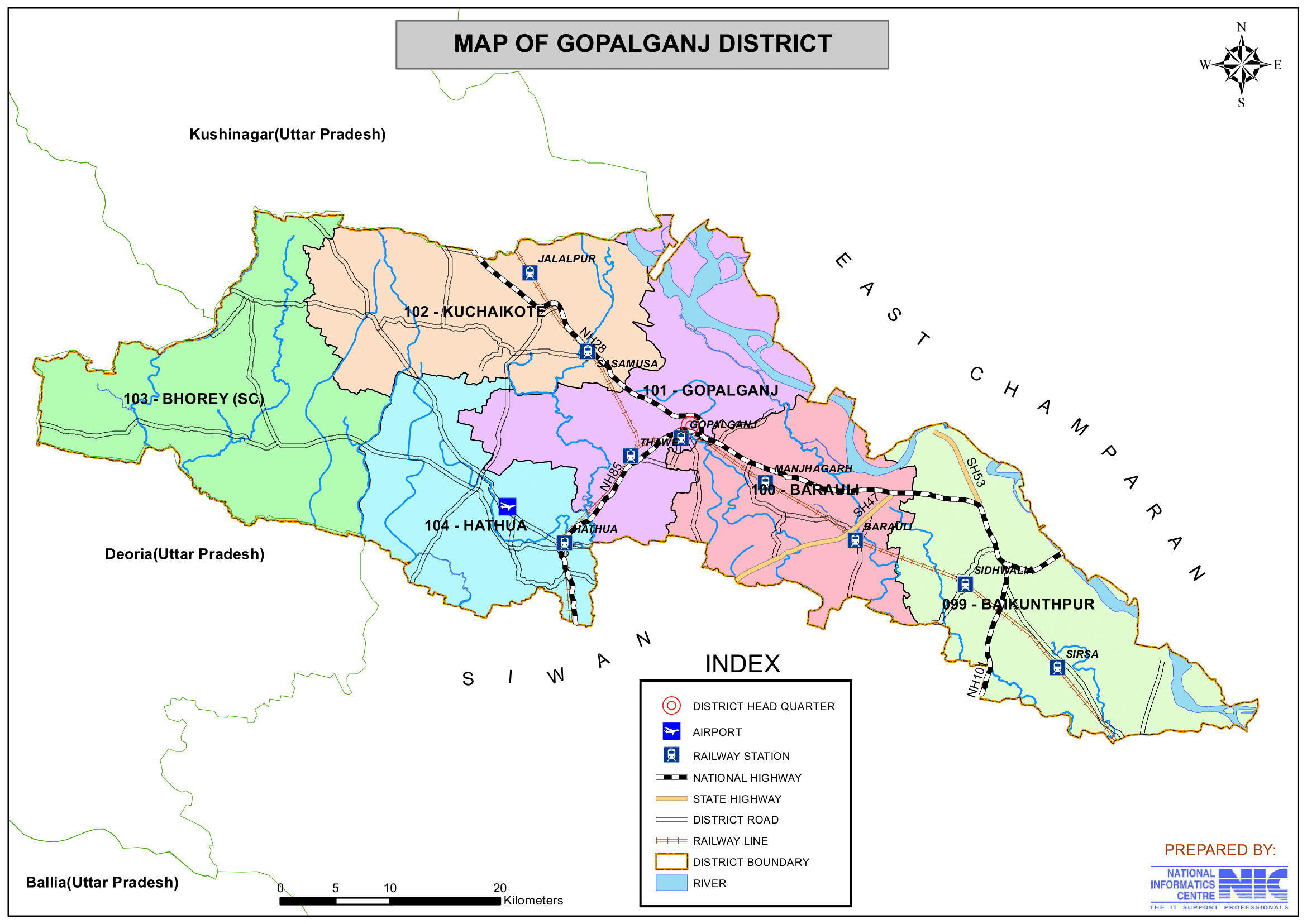
The district administrative headquarters is located at Gopalganj town and a part of the Saran Division. The district shares approximately 104 km of its boundary with Uttar Pradesh, and the internal district length is 78 km. It is a part of the Bhojpuri-speaking region and has contributed significantly to Bihar’s politics and administration. The district is famous for sugarcane production, and it has a significant influence from both Hindu and Muslim cultures.
Ancient and Medieval History
Gopalganj has a rich historical legacy, tracing its roots back to the Vedic age. During the Mahabharata era, this region was ruled by King Bhuri Sarwa. Historians, based on analysis of evidence, believe that this region was once under the rule of the King of Videh. During the Aryan period, the region was ruled by the Vaman King of the Chero tribe. The rulers of that time were known for their inclination towards constructing temples and religious monuments, which is why Gopalganj is home to numerous sacred sites.
Some of the prominent religious and historical landmarks in the district include: Durga Temple of Thawe, Fort of Manjha, Vaman Gandey Pond of Dighwa Dubauli, Fort of King Malkhan of Sirisia and Kuchaikote Fort. In the 13th and 16th centuries, Sultan of Bengal, Ghiyasuddin Abbas, and Mughal Emperor Babur ruled over this territory.
Role in Freedom Movements
Gopalganj has been a significant center of national and social movements. The people of the district actively participated in the freedom struggle, the JP movement, and the movement for women’s education. The district also played a crucial role in the non-payment of tax movement and the prohibition movement of 1930 under the leadership of Babu Ganga Vishnu Rai and Babu Sunder Lal of Bankatta. One of the notable sacrifices from the district was made by Pandit Bhopal Pandey, who gave his life for India’s independence in 1935. The people of Gopalganj remain indebted to these freedom fighters for their contributions to the nation.
Formation of Gopalganj District
Gopalganj, initially a small hamlet, was declared a subdivision of the old Saran district in 1875. It remained a part of Saran until October 2, 1973, when it was carved out as an independent district. The former Saran district originally included Saran, Siwan, and Gopalganj, but after the reorganization, each became separate administrative districts.
Role of River Gandak in Agriculture
The Gandak River, along with its tributaries like Jharahi, Khanwa, Daha, and Dhanahi, plays a crucial role in making the land of Gopalganj highly fertile. The alluvial soil deposited by the river significantly boosts agricultural productivity, making the district prosperous. The Gandak River, originating from Nepal, continuously enriches the region’s soil and contributes significantly to the economy of the district.
Gopalganj stands as a testament to India’s ancient heritage, religious significance, and contribution to the nation’s freedom movement. The district continues to thrive due to its rich cultural past, geographical advantages, and the sacrifices of its people in shaping India’s history.
Key Facts About Gopalganj District
- Country:
 India
India - State:
 Bihar
Bihar - Division: Saran
- Established: October 2, 1973
- Area: 2,033 km2 (785 sq mi)
- Coordinates: 26.4654°N 84.4416°E
- District Headquarters: Gopalganj town
- Collector & District Magistrate: Shri Prashanth Kumar CH, IAS
- Superintendent of Police: Shri Avdhesh Dixit, IPS
- Regional Language: Bhojpuri
- Official Language: Hindi
- Population (2011):
- Total: 2,562,012
- Density: 1,260/km2 (3,300/sq mi), densely populated district in the state of Bihar.
- Literacy Rate: 65.47%
- Sex Ratio: 1021/1000
- Gram Panchayats: 234
- Number of Halkas: 101
- Total Villages: 1566
- Uninhabited Villages: 169
- No. of Subdivision: 2 (Hathua, Gopalganj)
- No. of Blocks/Circles: 14
- Gopalganj- Baikunthpur, Barauli, Gopalganj, Kuchaikote, Manjha, Thawe, Sidhwaliya, Bhorey.
- Hathua- Hathua, Kateya, Panchdewari, Phulwariya, Uchkagaon, Vijayipur.
- Police Station: 22
- Kateya, Gopalpur, Bijayipur, Phulwaria, Uchkagaon, Hathua, Bhorey, Sidhwalia, Bhisambharpur, Baikunthpur, Mahammadpur, Yadavpur, Sadar, Thawe, Barauli, Kuchaikote, Manjhagadh, Mirganj, Shripur O.P, Madhopur O.P, SC/ST Thana, Mahila Thana.
- Municipal Council (Nagar Parishad): 1 (Gopalganj)
- Nagar Panchayat: 3 (Barauli, Kateya, Mirganj)
- Lok Sabha constituency: 1 (Gopalganj)
- Vidhan Sabha constituencies: 6
- Baikunthpur, Barauli, Gopalganj, Kuchaikote, Bhore, Hathua
- Key Features:
- Fertile agricultural land, producing sugarcane, paddy, and wheat.
- Known for its lush greenery and proximity to rivers.
- Cultural importance due to temples and traditional festivals.
- Significance: A district with an agricultural backbone and cultural richness.
- Sub-Division STD Codes:
- Gopalganj: 06156
- Hathua: 06150
- Time Zone: UTC+05:30 (IST)
- Vehicle Registration: BR-28
- Major Highways: NH-28
- PIN Code: 841428 (District Headquarter)
- Head Post Office: Gopalganj (Post office Chowk)
- Electricity Distribution: North Bihar Power Distribution Company Ltd
- Official Website: gopalganj.nic.in
Geography
- Location: Gopalganj is located in northern Bihar and shares its borders with:
- West Champaran district – North
- Deoria district (Uttar Pradesh) – West
- Kushinagar district (Uttar Pradesh) – Northwest.
- Siwan district – South
- East Champaran district and River Gandak – East
- Muzaffarpur district and Saran district – Southeast
- Area: 2,033 square kilometers
- Topography:
- Flat Indo-Gangetic plains, highly fertile.
- Prone to flooding during monsoon due to river overflow.
- Climate:
- Hot summers, monsoon rains (June-September), and cool winters.
- Rivers:
- Major rivers passes through the district are Gandak, Ghoghri, Gandaki, Jamuhar, Sona Nala, Saran, Basi, Jharahi, Narayani, Daha or Sandi, Khanua, Khokhi, Dhamai and Jharahi.
- Gandak River – The most important river in the district.
- Jharahi, Daha, and Chhoti Gandak – Other significant rivers.
- Major rivers passes through the district are Gandak, Ghoghri, Gandaki, Jamuhar, Sona Nala, Saran, Basi, Jharahi, Narayani, Daha or Sandi, Khanua, Khokhi, Dhamai and Jharahi.
History
Ancient Period
- Gopalganj was historically a part of the ancient Magadh and Kosala kingdoms.
- It was influenced by Buddhism and Jainism, as it is close to Kushinagar (Uttar Pradesh), where Lord Buddha attained Mahaparinirvana.
Medieval Period
- During the Mughal era, Gopalganj was a center for agriculture and trade.
- The region saw conflicts between local landlords (zamindars) and Mughal rulers.
Colonial & Freedom Struggle Era
- Gopalganj played an important role in India’s independence movement.
- Several freedom fighters and political leaders emerged from this region.
- It was a part of the Saran district until 1973, when it was carved out as a separate district.
Demographics (As per the 2011 Census)
- Population:
- Total Population: Gopalganj district has a population of approximately 2,562,012.
- Males Population: 1,267,666 (49.48%)
- Females Population: 1,294,346 (50.52%)
- Population within the age group of (0 to 6 years): 449,530 (17.54%) of Total Population.
- Total Population: Gopalganj district has a population of approximately 2,562,012.
- Ranking: 163rd in India (Out of 640 districts).
- 21st-Ranks in terms of population in the state of Bihar.
- 26th-Ranks in terms of area in the state of Bihar.
- 13th-Ranks in terms of population per square kilometers, as against the state’s 1,106/km2 .
- 1st-Ranks in terms of sex-ratio (1,021) against the state’s 918.
- 6th-Ranks in terms of child sex-ratio (954) against state’s 935.
- Density: 1,260 persons per square kilometer (3,300/sq mi).
- Population Growth (2001–2011): 19.02% reflecting significant population increase.
- Sex Ratio: 1021 females per 1,000 males.
- Literacy Rate: 65.47%, higher than the state average and with significant efforts being made to improve education access and quality.
- Urban Population: 162,805 (6.35%) of the total population lives in urban areas.
- Rural Population: 2,399,207 (93.65%) of the total population lives in rural areas.
- Most Populated Village: Dighwa (21,100) under Baikuntpur C.D. Block of the district.
- Least Populated Village: Rini Math (1) under Bhorey C.D. Block of the district.
- Total Households: 411,930
- Block with highest number of villages: Kuchaikote C.D Block of the district (222 villages).
- Block with lowest number of villages: Sidhwalia C.D Block of the district (50 villages).
- Village that occupies largest area: Rampur Tengrahi (2,428 hectare), Comes under Gopalganj C.D. Block of the district.
- Village that occupies smallest area: Man urf Basant Chhapra (2 hectare), Comes under Baikunthpur C.D. Block of the district.
Religious Composition (2011 Census):
- The majority of the population follows Hinduism, with a significant Muslim community.
- Hinduism: 82.72%
- Scheduled Castes: (320,064) 12.49%
- Scheduled Tribes: (60,807) 2.37%
- Islam: 17.02%
- Other or not stated: 0.26%
- Hinduism: 82.72%
Languages Spoken:
- The primary languages spoken are Hindi, Bhojpuri (widely spoken), and Urdu.
- Bhojpuri: 96.09%
- Hindi: 1.85%
- Urdu: 1.76%
- Others: 0.30%
Administration
- Administrative Headquarters: Gopalganj town
- Subdivisions:
- The district has two subdivisions: Gopalganj Sadar and Hathua.
- Each subdivision is led by a subdivisional magistrate who is in charge of development, revenue-related tasks, and maintaining law and order.
- Blocks and Circles:
- Gopalganj district comprises 19 administrative Blocks and Circles, each responsible for local governance and development.
- Gopalganj- Baikunthpur, Barauli, Gopalganj, Kuchaikote, Manjha, Thawe, Sidhwaliya, Bhorey.
- Hathua- Hathua, Kateya, Panchdewari, Phulwariya, Uchkagaon, Vijayipur.
- A Circle officer (CO) leads each circle, while a Block Development Officer (BDO) leads each block.
- Gopalganj district comprises 19 administrative Blocks and Circles, each responsible for local governance and development.
- Lok Sabha Constituency: Gopalganj (SC-reserved seat)
- Vidhan Sabha (Assembly) Constituencies: The district has 6 Assembly seats
- 99- Baikunthpur, 100- Barauli, 101- Gopalganj, 102- Kuchaikote, 103- Bhore, 104- Hathua
Organization Chart

Overall Roles and responsibilities of the Collectorate: Plays a pivotal role in district administration and Responsible for maintaining law and order, planning, development, revenue, and disaster management within the district.
- Collector (I.A.S Cadre):
- Head of the District: Acts as the chief executive and District Magistrate.
- Law and Order: Maintains peace and enforces law and order in the district.
- Planning & Development: Oversees planning and development projects.
- Administration of Scheduled/Agency Areas: Manages areas designated as scheduled or under special agency administration.
- Election Management & Arms Licensing: Handles general elections and oversees the licensing of arms.
- Additional Collector (B.A.S Cadre):
- Revenue Administration: Runs revenue-related functions across various district departments.
- Additional District Magistrate: Shares responsibilities in maintaining law and order and administering civil functions.
- Key Responsibilities: Oversees civil supplies, land matters, management of mines and minerals, and supervises village officers.
- District Development Commissioner (B.A.S Cadre):
- Developmental Activities: Manages and coordinates various developmental initiatives across the district.
- Key Departments Overseen:
- District Medical and Health Department.
- Social Welfare Department.
- BC (Backward Classes) Welfare and BC Corporation.
- Disabled Welfare.
- Housing and other related departments.
- Additional Collector (Disaster) (B.A.S Cadre):
- Disaster Management: Focuses on planning and coordinating activities related to disaster management.
- Key Responsibilities: Oversees the disaster section and other related developmental departments during emergencies.
These roles collectively ensure that the district is well-governed, with a focus on maintaining law and order, efficient revenue collection, effective disaster management, and sustainable development across various sectors.
Economy
Agriculture:
- Agriculture is the backbone of the economy, with major crops including:
- Paddy, wheat, maize, sugarcane, pulses, and mustard.
- Vegetables like potatoes, onions, and tomatoes.
- Sugarcane farming is the most prominent agricultural activity and one of the largest sugarcane growing district in India.
- Challenges:
- Prone to flooding from the Gandak River.
- Need for better irrigation facilities and modern farming techniques.
Industries & Small Businesses:
- Sugar mills are one of the major industries in Gopalganj.
- Three sugar factories are currently operational in the district, located in Sasamusa, Gopalganj City, and Sidhwaliya.
- Ethanol Production: Two grain and sugarcane-based ethanol plants have recently begun production.
- Handloom and cottage industries are present but underdeveloped.
- Rice mills and food processing industries contribute to the local economy.
- Outmigration – A large number of people migrate to Delhi, Punjab, Maharashtra, and Gulf countries for jobs.
- Industrial Development:
- The government has allotted dedicated industrial areas in Gopalganj.
- Many new factories are expected to come up in the coming years, further boosting industrial activity.
Other Agro-Based and Small Scale Industries:
- Numerous rice mills
- Milk packaging plants
- Mustard oil plants
- Flour mills
- Cattle seed plants
- Plywood factory
- Egg layer firms
- Cement brick plants
- Various other small-scale industries contribute to the local economy.
Foreign Exchange & Remittances:
- Gopalganj ranks among the top districts in Bihar and is one of the ten highest districts in India in terms of foreign exchange earnings.
- A significant number of people from the district work in Gulf countries (e.g., Saudi Arabia, Oman, UAE, Bahrain, Iraq, Qatar, Kuwait, and Yemen), contributing to remittance inflows.
Per Capita Income:
- Gopalganj is among the top ten districts in Bihar in per capita income, ranked 7th out of 38 districts according to Niti Ayog data from the previous year.
This multifaceted economic profile, combining robust agricultural practices, active agro-based industries, industrial development initiatives, and significant remittance contributions, positions Gopalganj as a notable economic hub in Bihar.
Education
Gopalganj had limited options for quality education. Over time, the region has made significant progress in expanding educational facilities.
Types of Educational Institutions:
- Government-Run Schools and Colleges:
- Offer education in both English and Hindi mediums.
- Include recently established government engineering, polytechnic, teacher training, paramedical, and ITI colleges.
- Some Higher Educational Institutions:
- Gopalganj College, Gopalganj
- Hathua Raj College, Hathua
- M.S. College, Barauli
- Kamla Rai College, Gopalganj
- Mahendra Mahila College, Gopalganj
- Private Institutions:
- Run by private trusts and individuals.
- Most private schools use English as the medium of instruction.
- Two well-known CBSE-affiliated schools are:
- Imperial Public School (located in Hathwa)
- DAV Thawe
- Affiliation Boards:
- Schools are affiliated with either the Central Board for Secondary Education (CBSE) or the Bihar School Examination Board.
- Several government and private schools:
- D.A.V High School, Gopalganj
- Kendriya Vidhyalaya, Gopalganj
- M.M. Urdu High School, Gopalganj
- S.S Balika High School, Gopalganj
- Saninik School, Hathua, Gopalganj
- Bhudev Sanskrit High School, Gopalganj
- V.M High School, Town Thana, Gopalganj
- Jawahar Navodaya Vidhyalaya, Balesara, Mirgarnj, Gopalganj
- Ramratan Shahi High School, Bishunupur, Yadovpur, Gopalganj
- Specialized Schools:
- Sainik School:
- Prepares boys for entry into the National Defence Academy.
- Recognized for its disciplined environment and focus on defense education.
- Sainik School:
- Educational Pathway:
- Secondary Education: Typically involves 10 years of schooling.
- Higher Secondary Education: Students choose one of three streams—Arts, Commerce, or Science—after secondary education.
Recent Developments and Future Plans:
- Establishment of one Government Engineering College and two Government Polytechnic Colleges.
- New institutions have also been set up, including a Government Teacher Training College, a Paramedical College, and Government ITI Colleges.
- The Bihar Government has announced plans for a new medical college and hospital to be located in Gopalganj.
Challenges:
- Limited number of universities and technical institutes.
- Many students move to Patna, Delhi, and Kolkata for higher education.
These developments indicate a significant improvement in the education infrastructure of Gopalganj, providing a broad range of educational opportunities from basic schooling to specialized higher education and technical training. This growth is expected to further enhance the overall literacy and skill level of the region, supporting its economic and social development.
Culture & Festivals
Festivals:
- Chhath Puja:
- A major Hindu festival dedicated to the Sun God (Surya), celebrated with immense faith.
- Held twice a year:
- In Chaitra (summer)
- In Kartik (beginning of winter)
- Devotees observe rigorous rituals including holy bathing, fasting, and offering water (arghya) to the setting and rising sun.
- Makar Sankranti (Tila Sankranti):
- Celebrated at the beginning of summer and marks the harvest season.
- Considered auspicious as it symbolizes the commencement of a new year in Indian culture.
- Holi:
- One of the biggest and most colorful festivals in the district.
- Celebrated with great enthusiasm, where people engage in joyous, vibrant festivities that light up the atmosphere.
- Durga Puja, Diwali, Janamashtami, Kali Pooja, Sarswati Pooja, Nag Panchemi, Shiv Ratri, Bakarid, Eid and Muharram are also widely celebrated.
- Bhojpuri folk songs and dances are a major part of the cultural identity.
Cuisines:
- Traditional Staples:
- Daily meals typically include dishes such as sabzi (vegetable curry), roti (flatbread), dal (lentils), and bhaji (stir-fried vegetables).
- Signature Dishes:
- Litti Chokha: A popular Bihari delicacy made with roasted wheat balls (litti) served with mashed vegetables (chokha).
- Kadhi: A yogurt-based curry often spiced with traditional seasonings.
- Jhal Moori: A spicy snack mix, beloved by locals.
- Sattu: Roasted gram flour, used in various dishes and beverages like Sattu Paratha, Dal Pitha and Dal Puri.
- Staple Food:
- Rice is the primary staple, and many regional dishes are prepared using rice.
- Sweets & Desserts:
- Renowned for its mouthwatering sweets made with pure desi ghee, which are available in local sweet shops and are commonly prepared at home during ceremonial occasions.
- Sweets like Thekua and Malpua are famous.
- Champaran-style mutton (Ahuna Mutton) is a famous dish in the region.
Costumes:
- Traditional Male Attire:
- Dhotis, kurtas, and pajamas are commonly worn.
- Young men may also be seen in shirts and trousers, blending traditional and modern styles.
- Traditional Female Attire:
- Women traditionally wear Ghaghara (long skirts), choli (blouses) and Saree, reflecting the rich Hindu cultural heritage.
- Attire of the Muslim Community:
- Men: Typically dress in kurta and pajama.
- Women: Often wear burkas, following traditional Muslim attire.
- Overall Aesthetic:
- The costumes in Gopalganj are known for their colorful and beautifully crafted designs, reflecting the region’s diverse cultural influences.
Religions:
- Religious Composition:
- The district is predominantly Hindu, but it also has a significant Muslim community.
- Tribal communities also reside in Gopalganj, with many adhering to their own indigenous religious practices.
- Cultural Integration:
- The region’s cultural landscape is a vibrant mix of various religious traditions, with communities having coexisted for many decades (many have been residents since before 1973).
- Social Harmony:
- Despite the diversity, there is a strong sense of social unity and hospitality, which leaves a lasting impression on visitors.
- Heritage and Tradition:
- The rich tapestry of religious traditions contributes to a unique cultural heritage, which is evident in festivals, rituals, and everyday practices in Gopalganj.
Tourism & Historical Places
1. Thawe Temple / Thawe Wali Mata:
- Location & Accessibility:
- Situated in a village approximately 6 km south of the District Headquarters.
- Home to the junction station “Thawe” on the North Eastern Railway (Masrakh–Thawe section and Siwan–Gorakhpur loop-line).
- Historical Features:
- Contains an old fort with an obscure history; once the site of the Hathwa King’s palace, now in a state of decay.
- Religious Significance:
- Old Temple Dedicated to Goddess Durga:
- Known locally as “Thawe wali Mata”.
- Believed to fulfill devotees’ wishes regarding marital harmony and the blessing of children.
- Unique Botanical Feature:
- A peculiar tree within the temple enclosure, growing in a cross-like form; its botanical family remains unidentified.
- Old Temple Dedicated to Goddess Durga:
- Festivals & Cultural Impact:
- Hosts a big annual fair in the month of Chaitra (March–April).
- Devotees gather to offer oblations and worship, with water from the well and other offerings symbolically disappearing into the sacred “Yagya Kunda.”
2. Shri Pitambara Peeth (Maa Bagalamukhi):
- Location:
- Located in Kuchaikote, about 15 km from Gopalganj.
- Religious Significance:
- One of the most famous Shakti Peethas dedicated to Bagalamukhi, one of the ten Mahavidyas (great wisdom goddesses) in Hinduism.
- Iconography & Depictions:
- Bagalamukhi’s Appearance:
- Golden complexion, wearing yellow cloth, seated on a golden throne amidst an ocean of nectar and yellow lotuses.
- Adorned with a crescent moon on her head.
- Forms:
- Dwi-BhujA (Two-Handed):
- Depicted holding a club in her right hand (to beat the demon) and using her left hand to pull the demon’s tongue, symbolizing the power of “sthambhana” (paralysis).
- ChaturbhujA (Four-Handed):
- An alternative, less commonly depicted form.
- Dwi-BhujA (Two-Handed):
- Bagalamukhi’s Appearance:
- Cultural Importance:
- Devotees worship Bagalamukhi to remove misconceptions and delusions, attaining clarity and inner strength.
3. Dighwa-Dubauli:
- Location:
- A village in the extreme east of the Gopalganj subdivision.
- Approximately 56 km north of Chapra and 40 km southeast of Gopalganj.
- Functions as a railway station on the Chapra–Mashrak Section of the North Eastern Railway.
- Archaeological Features:
- Two Pyramidal-Shaped Mounds:
- Western Mound: Located adjacent to the southeastern end of the village.
- Eastern Mound: Approximately 640 feet southeast of the western mound, near the road.
- Shape: Both mounds have a pyramidal structure with four projecting corners, resembling a four-pointed star surmounted by a cone.
- Composition: Primarily clay mixed with small fragments of brick and pottery.
- Additional Mound:
- A round-shaped mound about 950 feet south of the eastern mound, measuring approximately 200 feet (N–S) by 140 feet (E–W), along with an old well.
- Local Legend:
- Believed to have been constructed by the Chero-Chai (Cheros), an aboriginal race that once held significant power in the area, now residing in the hills south of the Ganges.
- Two Pyramidal-Shaped Mounds:
4. Lakri Dargah:
- Location:
- A village situated about 24 km north of Siwan.
- Religious Significance:
- Known for its Muslim tomb (dargah), which gives the village its name.
- Historical Background:
- The tomb belongs to Shah Arzan, a Mohammedan saint from Patna.
- Legend states that the saint, drawn by the solitude of the area, performed a Chilla (40 days of religious contemplation) and established a religious institution (Khankhah) endowed by Emperor Aurangzeb.
- Cultural Impact:
- The anniversary of Shah Arzan’s death is celebrated on the 11th of Rabi-us-Sani every year, drawing large crowds of devotees.
Some Others attractions are:
- Hathua Raj Palace
- A historical palace built by the Hathua royal family.
- Gandak Barrage
- A popular site for boating and scenic views of the Gandak River.
- Manjha Fort
- A historical fort that reflects the medieval history of Bihar.
Transportation
Roadways:
- National Highway NH-27 connects Gopalganj to Patna, Gorakhpur, and other major cities.
- State highways provide good connectivity to nearby districts like Siwan, Saran, and West Champaran.
- Multiple bus services operate on this highway, offering commuting options within the state and to neighboring states.
Railways:
- Gopalganj Railway Station – A key railway junction on the Siwan-Gorakhpur route.
- Thawe Junction – Another major railway station in the district, serves local passengers, along with several other smaller stations, including:
- Hathua Road
- Sasamusa
- Sipaya (serves nearby areas such as Kuchaikote, Khutwania, Dubey Khariya, Vinod Khariya, and surrounding villages)
- Tamkuhi Road
- Gopalganj Railway Station
- New train services have been initiated from Thawe to key destinations such as: Delhi, Kolkata, Patna, Taranagar, Gorakhpur, Varanasi, and Lucknow.
Airways:
- Nearest Airport:
- Mahayogi Gorakhnath Airport (Gorakhpur Airport of Uttar Pradesh – 100 km away).
- Jay Prakash Narayan Airport (Patna Airport – 160 km away).
- Sabeya Airport is currently being included in the government UDAN scheme:
- Preliminary paperwork and mapping have started.
- Boundary identification for the airport is expected to commence soon.
Notable Personalities of Gopalganj
Kamla Rai:
- Freedom fighter and politician.
- Served as a Member of the Legislative Assembly (MLA) for Gopalganj in 1952 and 1957.
- First Chairman of the Saran District Board in 1947.
- Founder of Kamla Rai College in Gopalganj.
Gorakh Rai:
- Freedom fighter and politician.
- Elected as an MLA from the Barauni constituency in 1962.
Mukesh Kumar:
- Indian cricketer born in Gopalganj, Bihar.
- Right-arm medium-fast bowler.
- Plays for Bengal in domestic cricket.
- Selected for the Indian national team in 2022.
Ram Dulari Sinha (1922–1994):
- Freedom fighter and politician associated with the Indian National Congress.
- Former Union Minister and Governor of Kerala.
- First woman from Bihar to attain a master’s degree and to become a governor.
Abdul Ghafoor (1918–2004):
- Politician who served as the Chief Minister of Bihar from 1973 to 1975.
- Member of the Indian National Congress.
Lalu Prasad Yadav:
- Prominent Indian politician.
- Served as the Chief Minister of Bihar and as the Union Minister for Railways.
- Founder of the Rashtriya Janata Dal (RJD).
U. K. Sinha:
- Former Chairman of the Securities and Exchange Board of India (SEBI).
- Served as an Indian Administrative Service (IAS) officer.
Anurag Kumar:
- Director of the Indian Institute of Science (IISc), Bangalore.
- Renowned academic and researcher in electrical engineering.
Pankaj Tripathi:
- Acclaimed Indian actor known for work in Hindi cinema and web series.
- Recognized for versatile roles in films like “Newton,” “Stree,” and the “Mirzapur” series.
Alok Kumar Suman:
- Politician and Member of Parliament representing the Gopalganj constituency.
- Associated with the Janata Dal (United) party.
Subhash Singh:
- Politician from Bihar.
- Served as a Member of the Legislative Assembly.
Janak Ram:
- Politician from Bihar.
- Held various political positions in the state.
Amrendra Kumar Pandey:
- Politician from Bihar.
- Involved in regional political activities.
Shambhu Sharan Shrivastava:
- Politician from Bihar.
- Served in various capacities within the state government.
Nagina Rai:
- Politician who served as a Member of Parliament representing the Gopalganj Lok Sabha constituency.
Avinash Tiwary:
- Indian actor known for roles in films like “Laila Majnu” and “Bulbbul.”
Balraj Arpit:
- Former International Youth Representative of India at the United Nations.
- Computer scientist and entrepreneur.
Challenges & Issues
- Frequent Flooding – The Gandak River often overflows, causing damage to crops and villages.
- Lack of Industrial Development – The district is mostly dependent on agriculture.
- Unemployment & Migration – Many youths migrate to metros and Gulf countries for better opportunities.
- Need for Better Education & Healthcare – Few colleges and hospitals available, requiring urgent improvement.
- Poor Road Infrastructure in Rural Areas – Some interior villages lack proper connectivity.
Conclusion
Gopalganj is an agriculturally rich and culturally vibrant district of Bihar. Thawe Temple, Hathua Palace, and Gandak Barrage are key attractions. The district has great potential for growth in agriculture, sugar industries, and tourism. However, frequent floods, unemployment, and lack of industrialization remain major challenges. Investment in education, infrastructure, and industries can help Gopalganj emerge as a leading district in Bihar.
Would you like more details about any specific Topics on Bihar? Comment Below 😊
गोपालगंज जिला: बिहार की विरासत में विशेष महत्व वाली भूमि
अवलोकन
गोपालगंज जिला भारत के बिहार राज्य के उत्तर-पश्चिमी भाग में एक प्रशासनिक जिला है, जो अपने ऐतिहासिक महत्व, कृषि अर्थव्यवस्था और सांस्कृतिक विरासत के लिए जाना जाता है। 2,033 वर्ग किलोमीटर (785 वर्ग मील) के क्षेत्र में फैला गोपालगंज 83.54°E से 85.56°E देशांतर और 26.12°N से 26.39°N अक्षांश के बीच स्थित है, और उत्तर में पश्चिम चंपारण जिले, दक्षिण में सिवान जिले, पूर्व में पूर्वी चंपारण जिले और गंडक नदी, दक्षिण-पूर्व में मुजफ्फरपुर जिले और सारण जिले, पश्चिम में उत्तर प्रदेश के देवरिया जिले और उत्तर-पश्चिम में उत्तर प्रदेश के कुशीनगर जिले के साथ सीमा साझा करता है।
जिले का प्रशासनिक मुख्यालय गोपालगंज शहर में स्थित है और यह सारण डिवीजन का एक हिस्सा है। जिले की सीमा उत्तर प्रदेश के साथ लगभग 104 किमी की है, और आंतरिक जिले की लंबाई 78 किमी है। यह भोजपुरी भाषी क्षेत्र का हिस्सा है और इसने बिहार की राजनीति और प्रशासन में महत्वपूर्ण योगदान दिया है। यह जिला गन्ना उत्पादन के लिए प्रसिद्ध है और इस पर हिंदू और मुस्लिम दोनों संस्कृतियों का महत्वपूर्ण प्रभाव है।
प्राचीन और मध्यकालीन इतिहास
गोपालगंज की एक समृद्ध ऐतिहासिक विरासत है, जिसकी जड़ें वैदिक युग में हैं। महाभारत काल के दौरान, इस क्षेत्र पर राजा भूरी सरवा का शासन था। साक्ष्यों के विश्लेषण के आधार पर इतिहासकारों का मानना है कि यह क्षेत्र कभी विदेह के राजा के शासन के अधीन था। आर्य काल के दौरान, इस क्षेत्र पर चेरो जनजाति के वामन राजा का शासन था। उस समय के शासक मंदिरों और धार्मिक स्मारकों के निर्माण के प्रति अपने झुकाव के लिए जाने जाते थे, यही वजह है कि गोपालगंज में कई पवित्र स्थल हैं।
जिले के कुछ प्रमुख धार्मिक और ऐतिहासिक स्थलों में शामिल हैं: थावे का दुर्गा मंदिर, मांझा का किला, दिघवा दुबौली का वामन गांडेय तालाब, सिरिसिया के राजा मलखान का किला और कुचायकोट का किला। 13वीं और 16वीं शताब्दी में बंगाल के सुल्तान गयासुद्दीन अब्बास और मुगल सम्राट बाबर ने इस क्षेत्र पर शासन किया।
स्वतंत्रता आंदोलनों में भूमिका
गोपालगंज राष्ट्रीय और सामाजिक आंदोलनों का एक महत्वपूर्ण केंद्र रहा है। जिले के लोगों ने स्वतंत्रता संग्राम, जेपी आंदोलन और महिला शिक्षा के लिए आंदोलन में सक्रिय रूप से भाग लिया। बाबू गंगा विष्णु राय और बनकट्टा के बाबू सुंदर लाल के नेतृत्व में कर न चुकाने के आंदोलन और 1930 के निषेध आंदोलन में भी जिले ने महत्वपूर्ण भूमिका निभाई। जिले के उल्लेखनीय बलिदानों में से एक पंडित भोपाल पांडे ने दिया था, जिन्होंने 1935 में भारत की स्वतंत्रता के लिए अपना जीवन दिया था। गोपालगंज के लोग राष्ट्र के लिए उनके योगदान के लिए इन स्वतंत्रता सेनानियों के ऋणी हैं।
जिले का गठन
गोपालगंज, जो शुरू में एक छोटा सा गांव था, को 1875 में पुराने सारण जिले का उपखंड घोषित किया गया था। यह 2 अक्टूबर, 1973 तक सारण का हिस्सा रहा, जब इसे एक स्वतंत्र जिले के रूप में बनाया गया। पूर्व सारण जिले में मूल रूप से सारण, सीवान और गोपालगंज शामिल थे, लेकिन पुनर्गठन के बाद, प्रत्येक अलग-अलग प्रशासनिक जिले बन गए।
कृषि में गंडक नदी की भूमिका
गंडक नदी, झरही, खानवा, दाहा और धनही जैसी अपनी सहायक नदियों के साथ गोपालगंज की भूमि को अत्यधिक उपजाऊ बनाने में महत्वपूर्ण भूमिका निभाती है। नदी द्वारा जमा की गई जलोढ़ मिट्टी कृषि उत्पादकता को काफी बढ़ाती है, जिससे जिला समृद्ध होता है। नेपाल से निकलने वाली गंडक नदी लगातार क्षेत्र की मिट्टी को समृद्ध करती है और जिले की अर्थव्यवस्था में महत्वपूर्ण योगदान देती है।
गोपालगंज भारत की प्राचीन विरासत, धार्मिक महत्व और देश के स्वतंत्रता आंदोलन में योगदान का एक वसीयतनामा है। यह जिला अपने समृद्ध सांस्कृतिक अतीत, भौगोलिक लाभों और भारत के इतिहास को आकार देने में अपने लोगों के बलिदान के कारण लगातार फलता-फूलता रहा है।
गोपालगंज जिले के बारे में मुख्य तथ्य
- देश: भारत
- राज्य: बिहार
- प्रमंडल: सारण
- स्थापना: 2 अक्टूबर, 1973
- क्षेत्रफल: 2,033 km2 (785 वर्ग मील)
- निर्देशांक: 26.4654°N 84.4416°E
- जिला मुख्यालय: गोपालगंज शहर
- कलेक्टर और जिला मजिस्ट्रेट: श्री प्रशांत कुमार सीएच, IAS
- पुलिस अधीक्षक: श्री अवधेश दीक्षित, IPS
- क्षेत्रीय भाषा: भोजपुरी
- आधिकारिक भाषा: हिंदी
- जनसंख्या (2011):
- कुल: 2,562,012
- घनत्व: 1,260/km2 (3,300/वर्ग मील), बिहार राज्य में घनी आबादी वाला जिला।
- साक्षरता दर: 65.47%
- लिंगानुपात: 1021/1000
- ग्राम पंचायतें: 234
- हल्कों की संख्या: 101
- कुल गांव: 1566
- निर्जन गाँव: 169
- उपखंड की संख्या: 2 (हथुआ, गोपालगंज)
- ब्लॉक/सर्कल की संख्या: 14
- बैकुंठपुर, बरौली, गोपालगंज, कुचायकोट, मांझा, थावे, सिधवलिया, भोरे, हथुआ, कटेया, पंचदेवरी, फुलवरिया, उचकागांव, विजयीपुर
- पुलिस स्टेशन: 22
- कटेया, गोपालपुर, बिजयपुर, फुलवरिया, उचकागांव, हथुआ, भोरे, सिधवलिया, भिसंभारपुर, बैकुंठपुर, महम्मदपुर, यादवपुर, सदर, थावे, बरौली, कुचायकोट, मांझागढ़, मीरगंज, श्रीपुर ओ.पी., माधोपुर ओ.पी., एससी/एसटी थाना, महिला थाना।
- नगर परिषद: 1 (गोपालगंज)
- नगर पंचायत: 3 (बरौली, कटेया, मीरगंज)
- लोकसभा क्षेत्र: 1 (गोपालगंज)
- विधान सभा क्षेत्र: 6
- बैकुंठपुर, बरौली, गोपालगंज, कुचायकोट, भोरे, हथुआ
- प्रमुख विशेषताऐं:
- उपजाऊ कृषि भूमि, गन्ना, धान और गेहूं का उत्पादन।
- यह अपनी हरी-भरी हरियाली और नदियों से निकटता के लिए जाना जाता है।
- मंदिरों और पारंपरिक त्योहारों के कारण सांस्कृतिक महत्व।
- महत्व: कृषि रीढ़ और सांस्कृतिक समृद्धि वाला जिला।
- उप-विभाग एसटीडी कोड:
- गोपालगंज: 06156
- हथुआ: 06150
- समय क्षेत्र: UTC+05:30 (IST)
- वाहन पंजीकरण: BR-28
- प्रमुख राजमार्ग: NH-28
- पिन कोड: 841428 (जिला मुख्यालय)
- मुख्य डाकघर: गोपालगंज (डाकघर चौक)
- बिजली वितरण: उत्तर बिहार विद्युत वितरण कंपनी लिमिटेड
- आधिकारिक वेबसाइट: gopalganj.nic.in
भूगोल
- स्थान: गोपालगंज उत्तरी बिहार में स्थित है और इसकी सीमाएँ निम्नलिखित से मिलती हैं:
- पश्चिम चंपारण जिला – उत्तर
- देवरिया जिला (उत्तर प्रदेश) – पश्चिम
- कुशीनगर जिला (उत्तर प्रदेश) – उत्तर-पश्चिम।
- सीवान जिला – दक्षिण
- पूर्वी चंपारण जिला और गंडक नदी – पूर्व
- मुजफ्फरपुर जिला और सारण जिला – दक्षिण-पूर्व
- क्षेत्रफल: 2,033 वर्ग किलोमीटर
- स्थलाकृति:
- समतल भारत-गंगा के मैदान, अत्यधिक उपजाऊ।
- नदी के अतिप्रवाह के कारण मानसून के दौरान बाढ़ की संभावना।
- जलवायु:
- गर्म ग्रीष्मकाल, मानसून की बारिश (जून-सितंबर), और ठंडी सर्दियाँ।
- नदियाँ:
- जिले से होकर गुजरने वाली प्रमुख नदियाँ गंडक, घोघरी, गंडकी, जमुहार, सोना नाला, सारण, बासी, झरही, नारायणी, दाहा या सांडी, खनुआ, खोखी, धमई और झरही हैं।
- गंडक नदी – जिले की सबसे महत्वपूर्ण नदी।
इतिहास
प्राचीन काल
- गोपालगंज ऐतिहासिक रूप से प्राचीन मगध और कोसल साम्राज्य का हिस्सा था।
- यह बौद्ध धर्म और जैन धर्म से प्रभावित था, क्योंकि यह कुशीनगर (उत्तर प्रदेश) के करीब है, जहाँ भगवान बुद्ध ने महापरिनिर्वाण प्राप्त किया था।
मध्यकाल
- मुगल काल के दौरान, गोपालगंज कृषि और व्यापार का केंद्र था।
- इस क्षेत्र में स्थानीय जमींदारों (ज़मींदारों) और मुगल शासकों के बीच संघर्ष देखा गया।
औपनिवेशिक और स्वतंत्रता संग्राम युग
- गोपालगंज ने भारत के स्वतंत्रता आंदोलन में महत्वपूर्ण भूमिका निभाई।
- इस क्षेत्र से कई स्वतंत्रता सेनानी और राजनीतिक नेता उभरे।
- यह 1973 तक सारण जिले का हिस्सा था, जब इसे एक अलग जिले के रूप में बनाया गया था।
जनसांख्यिकी (2011 की जनगणना के अनुसार)
जनसंख्या:
- कुल जनसंख्या: गोपालगंज जिले की जनसंख्या लगभग 2,562,012 है।
- पुरुष जनसंख्या: 1,267,666 (49.48%)
- महिला जनसंख्या: 1,294,346 (50.52%)
- (0 से 6 वर्ष) आयु वर्ग की जनसंख्या: कुल जनसंख्या का 449,530 (17.54%)।
- रैंकिंग: भारत में 163वाँ (640 जिलों में से)।
- बिहार राज्य में जनसंख्या के मामले में 21वाँ स्थान।
- बिहार राज्य में क्षेत्रफल के मामले में 26वाँ स्थान।
- राज्य की 1,106/km2 की तुलना में प्रति वर्ग किलोमीटर जनसंख्या के मामले में 13वाँ स्थान।
- लिंगानुपात (1,021) के मामले में राज्य के 918 के मुकाबले प्रथम स्थान पर।
- बाल लिंगानुपात (954) के मामले में राज्य के 935 के मुकाबले छठा स्थान।
- घनत्व: 1,260 व्यक्ति प्रति वर्ग किलोमीटर (3,300/वर्ग मील)।
- जनसंख्या वृद्धि (2001-2011): 19.02%, जो महत्वपूर्ण जनसंख्या वृद्धि को दर्शाता है।
- लिंग अनुपात: 1,000 पुरुषों पर 1021 महिलाएं।
- साक्षरता दर: 65.47%, जो राज्य औसत से अधिक है और शिक्षा की पहुंच और गुणवत्ता में सुधार के लिए महत्वपूर्ण प्रयास किए जा रहे हैं।
- शहरी जनसंख्या: कुल जनसंख्या का 162,805 (6.35%) शहरी क्षेत्रों में रहता है।
- ग्रामीण जनसंख्या: कुल जनसंख्या का 2,399,207 (93.65%) ग्रामीण क्षेत्रों में रहता है।
- सबसे अधिक आबादी वाला गांव: जिले के बैकुंठपुर सी.डी. ब्लॉक के अंतर्गत दिघवा (21,100)।
- सबसे कम आबादी वाला गांव: जिले के भोरे सी.डी. ब्लॉक के अंतर्गत रिनी मठ (1)।
- कुल परिवार: 411,930
- सबसे अधिक गांवों वाला ब्लॉक: जिले का कुचायकोट सी.डी. ब्लॉक (222 गांव)।
- सबसे कम गांवों वाला ब्लॉक: जिले का सिधवलिया सी.डी. ब्लॉक (50 गांव)।
- अधिक क्षेत्रफल वाला गांव: रामपुर टेंगराही (2,428 हेक्टेयर), जिले के गोपालगंज सी.डी. ब्लॉक के अंतर्गत आता है।
- सबसे कम क्षेत्रफल वाला गांव: मन उर्फ बसंत छपरा (2 हेक्टेयर), जिले के बैकुंठपुर सी.डी. ब्लॉक के अंतर्गत आता है।
धार्मिक संरचना (2011 की जनगणना):
- अधिकांश आबादी हिंदू धर्म का पालन करती है, जिसमें एक महत्वपूर्ण मुस्लिम समुदाय है।
- हिंदू धर्म: 82.72%
- अनुसूचित जाति: (320,064) 12.49%
- अनुसूचित जनजाति: (60,807) 2.37%
- इस्लाम: 17.02%
- अन्य या नहीं बताया गया: 0.26%
बोली जाने वाली भाषाएँ:
- बोली जाने वाली मुख्य भाषाएँ हिंदी, भोजपुरी (व्यापक रूप से बोली जाने वाली) और उर्दू हैं।
- भोजपुरी: 96.09%
- हिंदी: 1.85%
- उर्दू: 1.76%
- अन्य: 0.30%
प्रशासन
- प्रशासनिक मुख्यालय: गोपालगंज शहर
- उपखंड:
- जिले में दो उपखंड हैं: गोपालगंज सदर और हथुआ।
- प्रत्येक उपखंड का नेतृत्व एक उपखंड मजिस्ट्रेट करता है जो विकास, राजस्व संबंधी कार्यों और कानून व्यवस्था बनाए रखने का प्रभारी होता है।
- ब्लॉक और सर्कल:
- गोपालगंज जिले में बैकुंठपुर, बरौली, गोपालगंज, कुचायकोट, मांझा, थावे, सिधवलिया, भोरे, हथुआ, कटेया, पंचदेवरी, फुलवरिया, उचकागांव और विजयीपुर जैसे 19 प्रशासनिक ब्लॉक और सर्कल शामिल हैं, जिनमें से प्रत्येक स्थानीय शासन और विकास के लिए जिम्मेदार है।
- प्रत्येक सर्कल का नेतृत्व एक सर्कल अधिकारी (सीओ) करता है, जबकि प्रत्येक ब्लॉक का नेतृत्व एक खंड विकास अधिकारी (बीडीओ) करता है।
- लोकसभा निर्वाचन क्षेत्र: गोपालगंज (एससी-आरक्षित सीट)
- विधानसभा निर्वाचन क्षेत्र: जिले में 6 विधानसभा सीटें हैं
- बैकुंठपुर, बरौली, गोपालगंज, कुचायकोट, भोरे, हथुआ
कलेक्टरेट की समग्र भूमिकाएँ और जिम्मेदारियाँ:
जिला प्रशासन में एक महत्वपूर्ण भूमिका निभाता है और जिले के भीतर कानून और व्यवस्था, योजना, विकास, राजस्व और आपदा प्रबंधन को बनाए रखने के लिए जिम्मेदार होता है।
- कलेक्टर (आई.ए.एस. कैडर):
- जिले का मुखिया: मुख्य कार्यकारी और जिला मजिस्ट्रेट के रूप में कार्य करता है।
- कानून और व्यवस्था: जिले में शांति बनाए रखता है और कानून और व्यवस्था लागू करता है।
- योजना और विकास: योजना और विकास परियोजनाओं की देखरेख करता है।
- अनुसूचित/एजेंसी क्षेत्रों का प्रशासन: अनुसूचित या विशेष एजेंसी प्रशासन के तहत नामित क्षेत्रों का प्रबंधन करता है।
- चुनाव प्रबंधन और शस्त्र लाइसेंसिंग: आम चुनावों को संभालता है और हथियारों के लाइसेंसिंग की देखरेख करता है।
- अतिरिक्त कलेक्टर (बी.ए.एस. कैडर):
- राजस्व प्रशासन: विभिन्न जिला विभागों में राजस्व से संबंधित कार्यों को चलाता है।
- अतिरिक्त जिला मजिस्ट्रेट: कानून और व्यवस्था बनाए रखने और नागरिक कार्यों को प्रशासित करने में जिम्मेदारियों को साझा करता है।
- मुख्य जिम्मेदारियाँ: नागरिक आपूर्ति, भूमि मामलों, खानों और खनिजों के प्रबंधन की देखरेख करना और ग्राम अधिकारियों की देखरेख करना।
- जिला विकास आयुक्त (बी.ए.एस. कैडर):
- विकासात्मक गतिविधियाँ: जिले भर में विभिन्न विकासात्मक पहलों का प्रबंधन और समन्वय करना।
- देखे जाने वाले मुख्य विभाग:
- जिला चिकित्सा और स्वास्थ्य विभाग।
- समाज कल्याण विभाग।
- बीसी (पिछड़ा वर्ग) कल्याण और बीसी निगम।
- विकलांग कल्याण।
- आवास और अन्य संबंधित विभाग।
- अतिरिक्त कलेक्टर (आपदा) (बी.ए.एस. कैडर):
- आपदा प्रबंधन: आपदा प्रबंधन से संबंधित गतिविधियों की योजना बनाने और समन्वय करने पर ध्यान केंद्रित करता है।
- मुख्य जिम्मेदारियाँ: आपात स्थिति के दौरान आपदा अनुभाग और अन्य संबंधित विकास विभागों की देखरेख करना।
ये भूमिकाएँ सामूहिक रूप से सुनिश्चित करती हैं कि जिला अच्छी तरह से शासित हो, जिसमें कानून और व्यवस्था बनाए रखने, कुशल राजस्व संग्रह, प्रभावी आपदा प्रबंधन और विभिन्न क्षेत्रों में सतत विकास पर ध्यान केंद्रित किया जाता है।
अर्थव्यवस्था
कृषि:
- कृषि अर्थव्यवस्था की रीढ़ है, जिसमें प्रमुख फसलें शामिल हैं:
- धान, गेहूं, मक्का, गन्ना, दालें और सरसों।
- आलू, प्याज और टमाटर जैसी सब्जियाँ।
- गन्ने की खेती सबसे प्रमुख कृषि गतिविधि है और भारत में सबसे बड़े गन्ना उगाने वाले जिलों में से एक है।
- चुनौतियाँ:
- गंडक नदी से बाढ़ आने की संभावना।
- बेहतर सिंचाई सुविधाओं और आधुनिक कृषि तकनीकों की आवश्यकता।
उद्योग और छोटे व्यवसाय:
- गोपालगंज में चीनी मिलें प्रमुख उद्योगों में से एक हैं।
- जिले में वर्तमान में तीन चीनी मिलें चालू हैं, जो सासामुसा, गोपालगंज शहर और सिधवलिया में स्थित हैं।
- इथेनॉल उत्पादन: दो अनाज और गन्ना आधारित इथेनॉल संयंत्रों ने हाल ही में उत्पादन शुरू किया है।
- हथकरघा और कुटीर उद्योग मौजूद हैं, लेकिन अविकसित हैं।
- चावल मिलें और खाद्य प्रसंस्करण उद्योग स्थानीय अर्थव्यवस्था में योगदान करते हैं।
- प्रवास – बड़ी संख्या में लोग नौकरियों के लिए दिल्ली, पंजाब, महाराष्ट्र और खाड़ी देशों में जाते हैं। औद्योगिक विकास:
- सरकार ने गोपालगंज में समर्पित औद्योगिक क्षेत्र आवंटित किए हैं।
- आने वाले वर्षों में कई नई फैक्ट्रियाँ लगने की उम्मीद है, जिससे औद्योगिक गतिविधि को और बढ़ावा मिलेगा।
अन्य कृषि-आधारित और लघु उद्योग:
- अनेक चावल मिलें
- दूध पैकेजिंग संयंत्र
- सरसों तेल संयंत्र
- आटा मिलें
- पशु बीज संयंत्र
- प्लाईवुड कारखाना
- अंडा परत फर्म
- सीमेंट ईंट संयंत्र
- विभिन्न अन्य लघु उद्योग स्थानीय अर्थव्यवस्था में योगदान करते हैं।
विदेशी मुद्रा और प्रेषण:
- गोपालगंज बिहार के शीर्ष जिलों में शुमार है और विदेशी मुद्रा आय के मामले में भारत के दस सबसे अधिक जिलों में से एक है।
- जिले के बहुत से लोग खाड़ी देशों (जैसे, सऊदी अरब, ओमान, यूएई, बहरीन, इराक, कतर, कुवैत और यमन) में काम करते हैं, जो प्रेषण प्रवाह में योगदान करते हैं।
प्रति व्यक्ति आय:
- नीति आयोग के पिछले वर्ष के आंकड़ों के अनुसार गोपालगंज प्रति व्यक्ति आय के मामले में बिहार के शीर्ष दस जिलों में से एक है, जो 38 जिलों में से 7वें स्थान पर है।
यह बहुआयामी आर्थिक प्रोफ़ाइल, मज़बूत कृषि पद्धतियों, सक्रिय कृषि-आधारित उद्योगों, औद्योगिक विकास पहलों और महत्वपूर्ण प्रेषण योगदानों को मिलाकर गोपालगंज को बिहार में एक उल्लेखनीय आर्थिक केंद्र के रूप में स्थापित करती है।
शिक्षा
गोपालगंज में गुणवत्तापूर्ण शिक्षा के लिए सीमित विकल्प थे। समय के साथ, इस क्षेत्र ने शैक्षिक सुविधाओं के विस्तार में महत्वपूर्ण प्रगति की है।
शैक्षणिक संस्थानों के प्रकार:
- सरकारी स्कूल और कॉलेज:
- अंग्रेजी और हिंदी दोनों माध्यमों में शिक्षा प्रदान करते हैं।
- हाल ही में स्थापित सरकारी इंजीनियरिंग, पॉलिटेक्निक, शिक्षक प्रशिक्षण, पैरामेडिकल और आईटीआई कॉलेज शामिल हैं।
- कुछ उच्च शिक्षण संस्थान:
- गोपालगंज कॉलेज, गोपालगंज
- हथुआ राज कॉलेज, हथुआ
- एम.एस. कॉलेज, बरौली
- कमला राय कॉलेज, गोपालगंज
- महेंद्र महिला कॉलेज, गोपालगंज
- निजी संस्थान:
- निजी ट्रस्ट और व्यक्तियों द्वारा संचालित।
- अधिकांश निजी स्कूल शिक्षण के माध्यम के रूप में अंग्रेजी का उपयोग करते हैं।
- दो प्रसिद्ध सीबीएसई-संबद्ध स्कूल हैं:
- इम्पीरियल पब्लिक स्कूल (हथवा में स्थित)
- डीएवी थावे
- संबद्धता बोर्ड:
- स्कूल या तो केंद्रीय माध्यमिक शिक्षा बोर्ड (सीबीएसई) या बिहार विद्यालय परीक्षा बोर्ड से संबद्ध हैं।
- कई सरकारी और निजी स्कूल:
- डीएवी हाई स्कूल, गोपालगंज
- केंद्रीय विद्यालय, गोपालगंज
- एमएम उर्दू हाई स्कूल, गोपालगंज
- एसएस बालिका हाई स्कूल, गोपालगंज
- सैनिक स्कूल, हथुआ, गोपालगंज
- भूदेव संस्कृत हाई स्कूल, गोपालगंज
- वीएम हाई स्कूल, टाउन थाना, गोपालगंज
- जवाहर नवोदय विद्यालय, बलेसरा, मीरगंज, गोपालगंज
- रामरतन शाही हाई स्कूल, बिशुनपुर, यादोवपुर, गोपालगंज
- विशेष स्कूल:
- सैनिक स्कूल:
- लड़कों को राष्ट्रीय रक्षा अकादमी में प्रवेश के लिए तैयार करता है।
- अपने अनुशासित वातावरण और रक्षा शिक्षा पर ध्यान केंद्रित करने के लिए जाना जाता है।
- सैनिक स्कूल:
- शैक्षणिक मार्ग:
- माध्यमिक शिक्षा: इसमें आमतौर पर 10 साल की स्कूली शिक्षा शामिल होती है।
- उच्चतर माध्यमिक शिक्षा: माध्यमिक शिक्षा के बाद छात्र तीन धाराओं में से एक चुनते हैं – कला, वाणिज्य या विज्ञान।
हाल के विकास और भविष्य की योजनाएँ:
- एक सरकारी इंजीनियरिंग कॉलेज और दो सरकारी पॉलिटेक्निक कॉलेजों की स्थापना।
- नए संस्थान भी स्थापित किए गए हैं, जिनमें एक सरकारी शिक्षक प्रशिक्षण कॉलेज, एक पैरामेडिकल कॉलेज और सरकारी आईटीआई कॉलेज शामिल हैं।
- बिहार सरकार ने गोपालगंज में एक नए मेडिकल कॉलेज और अस्पताल की स्थापना की योजना की घोषणा की है।
चुनौतियाँ:
- विश्वविद्यालयों और तकनीकी संस्थानों की सीमित संख्या।
- बहुत से छात्र उच्च शिक्षा के लिए पटना, दिल्ली और कोलकाता जाते हैं।
ये विकास गोपालगंज के शिक्षा बुनियादी ढांचे में महत्वपूर्ण सुधार का संकेत देते हैं, जो बुनियादी स्कूली शिक्षा से लेकर विशेष उच्च शिक्षा और तकनीकी प्रशिक्षण तक की व्यापक शैक्षिक अवसर प्रदान करता है। इस वृद्धि से क्षेत्र की समग्र साक्षरता और कौशल स्तर में और वृद्धि होने की उम्मीद है, जिससे इसके आर्थिक और सामाजिक विकास को समर्थन मिलेगा।
संस्कृति और त्यौहार
त्यौहार:
- छठ पूजा:
- सूर्यदेवता को समर्पित एक प्रमुख हिंदू त्यौहार, जिसे अपार आस्था के साथ मनाया जाता है।
- वर्ष में दो बार मनाया जाता है:
- चैत्र (गर्मी)
- कार्तिक (सर्दियों की शुरुआत)
- भक्त पवित्र स्नान, उपवास और डूबते और उगते सूर्य को जल (अर्घ्य) चढ़ाने सहित कठोर अनुष्ठान करते हैं।
- मकर संक्रांति (तिला संक्रांति):
- गर्मियों की शुरुआत में मनाया जाता है और फसल के मौसम का प्रतीक है।
- इसे शुभ माना जाता है क्योंकि यह भारतीय संस्कृति में नए साल की शुरुआत का प्रतीक है।
- होली:
- जिले में सबसे बड़े और सबसे रंगीन त्योहारों में से एक।
- बहुत उत्साह के साथ मनाया जाता है, जहाँ लोग खुशी और जीवंत उत्सव मनाते हैं जो माहौल को रोशन कर देते हैं।
- दुर्गा पूजा, दिवाली, जन्माष्टमी, काली पूजा, सरस्वती पूजा, नाग पंचमी, शिव रात्रि, बकरीद, ईद और मुहर्रम भी व्यापक रूप से मनाए जाते हैं।
- भोजपुरी लोकगीत और नृत्य सांस्कृतिक पहचान का एक प्रमुख हिस्सा हैं।
व्यंजन:
- पारंपरिक स्टेपल:
- दैनिक भोजन में आमतौर पर सब्ज़ी (सब्जी करी), रोटी (चपटी रोटी), दाल (दाल), और भाजी (हलचल-तली हुई सब्जियाँ) जैसे व्यंजन शामिल होते हैं।
- विशिष्ट व्यंजन:
- लिट्टी चोखा: भुने हुए गेहूँ के गोले (लिट्टी) से बना एक लोकप्रिय बिहारी व्यंजन जिसे मसली हुई सब्ज़ियों (चोखा) के साथ परोसा जाता है।
- कढ़ी: दही से बनी करी जिसे अक्सर पारंपरिक मसालों के साथ पकाया जाता है।
- झाल मूरी: स्थानीय लोगों द्वारा पसंद किया जाने वाला एक मसालेदार नाश्ता मिश्रण।
- सत्तू: भुना हुआ बेसन, सत्तू पराठा, दाल पीठा और दाल पूरी जैसे कई व्यंजनों और पेय पदार्थों में इस्तेमाल किया जाता है।
- मुख्य भोजन:
- चावल मुख्य भोजन है, और कई क्षेत्रीय व्यंजन चावल से बनाए जाते हैं।
- मिठाई और डेसर्ट:
- शुद्ध देसी घी से बनी अपनी मुंह में पानी लाने वाली मिठाइयों के लिए प्रसिद्ध, जो स्थानीय मिठाई की दुकानों में उपलब्ध हैं और आमतौर पर घर पर औपचारिक अवसरों के दौरान बनाई जाती हैं।
- ठेकुआ और मालपुआ जैसी मिठाइयाँ प्रसिद्ध हैं।
- चंपारण शैली का मटन (अहुना मटन) इस क्षेत्र का एक प्रसिद्ध व्यंजन है।
वेशभूषा:
- पारंपरिक पुरुष पोशाक:
- धोती, कुर्ता और पायजामा आमतौर पर पहने जाते हैं।
- युवा पुरुषों को शर्ट और पतलून में भी देखा जा सकता है, जो पारंपरिक और आधुनिक शैलियों का मिश्रण है।
- पारंपरिक महिला पोशाक:
- महिलाएं पारंपरिक रूप से घाघरा (लंबी स्कर्ट), चोली (ब्लाउज) और साड़ी पहनती हैं, जो समृद्ध हिंदू सांस्कृतिक विरासत को दर्शाता है।
- मुस्लिम समुदाय की पोशाक:
- पुरुष: आमतौर पर कुर्ता और पायजामा पहनते हैं।
- महिलाएं: अक्सर पारंपरिक मुस्लिम पोशाक का पालन करते हुए बुर्का पहनती हैं।
- कुल मिलाकर सौंदर्य:
- गोपालगंज में वेशभूषा उनके रंगीन और खूबसूरती से तैयार किए गए डिज़ाइन के लिए जानी जाती है, जो क्षेत्र के विविध सांस्कृतिक प्रभावों को दर्शाती है।
धर्म:
- धार्मिक संरचना:
- यह जिला मुख्य रूप से हिंदू है, लेकिन इसमें एक महत्वपूर्ण मुस्लिम समुदाय भी है।
- गोपालगंज में आदिवासी समुदाय भी रहते हैं, जिनमें से कई अपनी स्वदेशी धार्मिक प्रथाओं का पालन करते हैं।
- सांस्कृतिक एकीकरण:
- क्षेत्र का सांस्कृतिक परिदृश्य विभिन्न धार्मिक परंपराओं का जीवंत मिश्रण है, जिसमें कई समुदाय कई दशकों से सह-अस्तित्व में हैं (कई लोग 1973 से पहले से ही यहाँ के निवासी हैं)।
- सामाजिक सद्भाव:
- विविधता के बावजूद, यहाँ सामाजिक एकता और आतिथ्य की भावना प्रबल है, जो आगंतुकों पर एक स्थायी छाप छोड़ती है।
- विरासत और परंपरा:
- धार्मिक परंपराओं की समृद्ध ताने-बाने ने एक अनूठी सांस्कृतिक विरासत में योगदान दिया है, जो गोपालगंज में त्योहारों, अनुष्ठानों और रोज़मर्रा की प्रथाओं में स्पष्ट है।
पर्यटन एवं ऐतिहासिक स्थल
1. थावे मंदिर / थावे वाली माता:
- स्थान एवं पहुँच:
- जिला मुख्यालय से लगभग 6 किमी दक्षिण में एक गाँव में स्थित है।
- उत्तर पूर्वी रेलवे (मसरक-थावे खंड और सीवान-गोरखपुर लूप-लाइन) पर जंक्शन स्टेशन “थावे” का घर।
- ऐतिहासिक विशेषताएँ:
- एक पुराना किला है जिसका इतिहास अस्पष्ट है; कभी हथवा राजा के महल का स्थान था, जो अब जीर्ण-शीर्ण अवस्था में है।
- धार्मिक महत्व:
- देवी दुर्गा को समर्पित पुराना मंदिर:
- स्थानीय रूप से “थावे वाली माता” के रूप में जाना जाता है।
- माना जाता है कि वैवाहिक सद्भाव और बच्चों के आशीर्वाद से संबंधित भक्तों की इच्छाएँ पूरी होती हैं।
- अद्वितीय वनस्पति विशेषता:
- मंदिर के परिसर में एक अनोखा पेड़ है, जो क्रॉस के आकार में उगता है; इसका वनस्पति परिवार अज्ञात है।
- देवी दुर्गा को समर्पित पुराना मंदिर:
- त्यौहार और सांस्कृतिक प्रभाव:
- चैत्र (मार्च-अप्रैल) के महीने में एक बड़ा वार्षिक मेला आयोजित होता है।
- भक्तगण आहुति देने और पूजा करने के लिए एकत्रित होते हैं, कुएं से पानी और अन्य प्रसाद प्रतीकात्मक रूप से पवित्र “यज्ञ कुंड” में समा जाते हैं।
2. श्री पीताम्बरा पीठ (माँ बगलामुखी):
- स्थान:
- गोपालगंज से लगभग 15 किमी दूर कुचायकोट में स्थित है।
- धार्मिक महत्व:
- हिंदू धर्म में दस महाविद्याओं (महान ज्ञान देवियों) में से एक बगलामुखी को समर्पित सबसे प्रसिद्ध शक्ति पीठों में से एक।
- प्रतिमा और चित्रण:
- बगलमुखी का स्वरूप:
- सुनहरे रंग की, पीले कपड़े पहने, अमृत और पीले कमल के सागर के बीच एक सुनहरे सिंहासन पर बैठी हुई।
- सिर पर अर्धचंद्र सुशोभित।
- रूप:
- द्वी-भुजा (दो हाथ वाली):
- दाहिने हाथ में एक डंडा पकड़े हुए (राक्षस को हराने के लिए) और अपने बाएं हाथ से राक्षस की जीभ को खींचते हुए, “स्तंभन” (पक्षाघात) की शक्ति का प्रतीक।
- चतुर्भुजा (चार हाथ वाली):
- एक वैकल्पिक, कम आम तौर पर दर्शाया जाने वाला रूप।
- द्वी-भुजा (दो हाथ वाली):
- बगलमुखी का स्वरूप:
- सांस्कृतिक महत्व:
- भक्त गलत धारणाओं और भ्रमों को दूर करने, स्पष्टता और आंतरिक शक्ति प्राप्त करने के लिए बगलामुखी की पूजा करते हैं।
3. दिघवा-दुबौली:
- स्थान:
- गोपालगंज उपखंड के सुदूर पूर्व में एक गाँव।
- छपरा से लगभग 56 किमी उत्तर और गोपालगंज से 40 किमी दक्षिण-पूर्व में।
- उत्तर पूर्वी रेलवे के छपरा-मशरक खंड पर एक रेलवे स्टेशन के रूप में कार्य करता है।
- पुरातात्विक विशेषताएँ:
- दो पिरामिडनुमा टीले:
- पश्चिमी टीला: गाँव के दक्षिण-पूर्वी छोर के समीप स्थित है।
- पूर्वी टीला: पश्चिमी टीले से लगभग 640 फीट दक्षिण-पूर्व में, सड़क के पास।
- आकार: दोनों टीलों में चार उभरे हुए कोनों वाली पिरामिडनुमा संरचना है, जो एक शंकु द्वारा घिरे चार-नुकीले तारे जैसा दिखता है।
- संरचना: मुख्य रूप से मिट्टी, ईंट और मिट्टी के बर्तनों के छोटे-छोटे टुकड़ों के साथ मिश्रित।
- अतिरिक्त टीला:
- पूर्वी टीले से लगभग 950 फीट दक्षिण में एक गोल आकार का टीला, जिसकी माप लगभग 200 फीट (उत्तर-दक्षिण) से 140 फीट (पूर्व-पश्चिम) है, साथ ही एक पुराना कुआँ भी है।
- स्थानीय किंवदंती:
- माना जाता है कि इसका निर्माण चेरो-चाई (चेरोस) द्वारा किया गया था, जो एक आदिवासी जाति थी, जो कभी इस क्षेत्र में महत्वपूर्ण शक्ति रखती थी, जो अब गंगा के दक्षिण की पहाड़ियों में रहती है।
- दो पिरामिडनुमा टीले:
4. लकरी दरगाह:
- स्थान:
- सीवान से लगभग 24 किलोमीटर उत्तर में स्थित एक गाँव।
- धार्मिक महत्व:
- यह अपने मुस्लिम मकबरे (दरगाह) के लिए जाना जाता है, जिसके कारण इस गाँव का नाम पड़ा।
- ऐतिहासिक पृष्ठभूमि:
- यह मकबरा पटना के एक मुसलमान संत शाह अरज़ान का है।
- किंवदंती है कि इस क्षेत्र के एकांत से आकर्षित होकर संत ने चिल्ला (धार्मिक चिंतन के 40 दिन) किया और सम्राट औरंगज़ेब द्वारा दान की गई एक धार्मिक संस्था (खानखाह) की स्थापना की।
- सांस्कृतिक प्रभाव:
- शाह अरज़ान की मृत्यु की वर्षगांठ हर साल रबी-उस-सनी की 11 तारीख को मनाई जाती है, जिसमें बड़ी संख्या में श्रद्धालु आते हैं।
कुछ अन्य आकर्षण हैं:
- हथुआ राज महल
- हथुआ राज परिवार द्वारा निर्मित एक ऐतिहासिक महल।
- गंडक बैराज
- नौका विहार और गंडक नदी के सुंदर दृश्यों के लिए एक लोकप्रिय स्थल।
- मांझा किला
- एक ऐतिहासिक किला जो बिहार के मध्यकालीन इतिहास को दर्शाता है।
परिवहन
सड़क मार्ग:
- राष्ट्रीय राजमार्ग NH-27 गोपालगंज को पटना, गोरखपुर और अन्य प्रमुख शहरों से जोड़ता है।
- राज्य राजमार्ग सीवान, सारण और पश्चिमी चंपारण जैसे आस-पास के जिलों को अच्छी कनेक्टिविटी प्रदान करते हैं।
- इस राजमार्ग पर कई बस सेवाएँ संचालित होती हैं, जो राज्य के भीतर और पड़ोसी राज्यों में आवागमन के विकल्प प्रदान करती हैं।
रेलवे:
- गोपालगंज रेलवे स्टेशन – सीवान-गोरखपुर मार्ग पर एक प्रमुख रेलवे जंक्शन।
- थावे जंक्शन – जिले का एक और प्रमुख रेलवे स्टेशन, स्थानीय यात्रियों के साथ-साथ कई अन्य छोटे स्टेशनों को भी सेवा प्रदान करता है, जिनमें शामिल हैं:
- हथुआ रोड
- सासामुसा
- सिपाया (कुचायकोट, खुटवानिया, दुबे खरिया, विनोद खरिया और आसपास के गाँवों जैसे आस-पास के क्षेत्रों को सेवा प्रदान करता है)
- तमकुही रोड
- गोपालगंज रेलवे स्टेशन
- थावे से दिल्ली, कोलकाता, पटना, तारानगर, गोरखपुर, वाराणसी और लखनऊ जैसे प्रमुख गंतव्यों के लिए नई ट्रेन सेवाएँ शुरू की गई हैं।
हवाई मार्ग:
- निकटतम हवाई अड्डा:
- महायोगी गोरखनाथ हवाई अड्डा (उत्तर प्रदेश का गोरखपुर हवाई अड्डा – 100 किमी दूर)।
- जय प्रकाश नारायण हवाई अड्डा (पटना हवाई अड्डा – 160 किमी दूर)।
- सबेया हवाई अड्डे को वर्तमान में सरकारी उड़ान योजना में शामिल किया जा रहा है:
- प्रारंभिक कागजी कार्रवाई और मानचित्रण शुरू हो गया है।
- हवाई अड्डे के लिए सीमा की पहचान जल्द ही शुरू होने की उम्मीद है।
गोपालगंज की उल्लेखनीय हस्तियां
कमला राय:
- स्वतंत्रता सेनानी और राजनीतिज्ञ।
- 1952 और 1957 में गोपालगंज के लिए विधान सभा के सदस्य (एमएलए) के रूप में कार्य किया।
- 1947 में सारण जिला बोर्ड के पहले अध्यक्ष।
- गोपालगंज में कमला राय कॉलेज के संस्थापक।
गोरख राय:
- स्वतंत्रता सेनानी और राजनीतिज्ञ।
- 1962 में बरौनी निर्वाचन क्षेत्र से विधायक चुने गए।
मुकेश कुमार:
- बिहार के गोपालगंज में जन्मे भारतीय क्रिकेटर।
- दाएं हाथ के मध्यम-तेज गेंदबाज।
- घरेलू क्रिकेट में बंगाल के लिए खेलते हैं।
- 2022 में भारतीय राष्ट्रीय टीम के लिए चुने गए।
राम दुलारी सिन्हा (1922-1994):
- भारतीय राष्ट्रीय कांग्रेस से जुड़ी स्वतंत्रता सेनानी और राजनीतिज्ञ।
- पूर्व केंद्रीय मंत्री और केरल की राज्यपाल।
- मास्टर डिग्री प्राप्त करने वाली और राज्यपाल बनने वाली बिहार की पहली महिला।
अब्दुल गफूर (1918-2004):
- राजनेता जिन्होंने 1973 से 1975 तक बिहार के मुख्यमंत्री के रूप में कार्य किया।
- भारतीय राष्ट्रीय कांग्रेस के सदस्य।
लालू प्रसाद यादव:
- प्रमुख भारतीय राजनीतिज्ञ।
- बिहार के मुख्यमंत्री और केंद्रीय रेल मंत्री के रूप में कार्य किया।
- राष्ट्रीय जनता दल (राजद) के संस्थापक।
यू. के. सिन्हा:
- भारतीय प्रतिभूति और विनिमय बोर्ड (सेबी) के पूर्व अध्यक्ष।
- भारतीय प्रशासनिक सेवा (आईएएस) अधिकारी के रूप में कार्य किया।
अनुराग कुमार:
- भारतीय विज्ञान संस्थान (आईआईएससी), बैंगलोर के निदेशक।
- विद्युत इंजीनियरिंग में प्रसिद्ध शिक्षाविद और शोधकर्ता।
पंकज त्रिपाठी:
- हिंदी सिनेमा और वेब सीरीज में काम करने के लिए जाने जाने वाले प्रशंसित भारतीय अभिनेता।
- “न्यूटन”, “स्त्री” और “मिर्जापुर” सीरीज जैसी फिल्मों में बहुमुखी भूमिकाओं के लिए पहचाने गए।
आलोक कुमार सुमन:
- गोपालगंज निर्वाचन क्षेत्र का प्रतिनिधित्व करने वाले राजनीतिज्ञ और सांसद।
- जनता दल (यूनाइटेड) पार्टी से जुड़े।
सुभाष सिंह:
- बिहार के राजनीतिज्ञ।
- विधानसभा के सदस्य के रूप में कार्य किया।
जनक राम:
- बिहार के राजनीतिज्ञ।
- राज्य में विभिन्न राजनीतिक पदों पर रहे।
अमरेंद्र कुमार पांडे:
- बिहार के राजनीतिज्ञ।
- क्षेत्रीय राजनीतिक गतिविधियों में शामिल।
शंभू शरण श्रीवास्तव:
- बिहार के राजनीतिज्ञ।
- राज्य सरकार में विभिन्न पदों पर कार्य किया।
नगीना राय:
- राजनेता जिन्होंने गोपालगंज लोकसभा निर्वाचन क्षेत्र का प्रतिनिधित्व करने वाले सांसद के रूप में कार्य किया।
अविनाश तिवारी:
- भारतीय अभिनेता जिन्हें “लैला मजनू” और “बुलबुल” जैसी फिल्मों में भूमिकाओं के लिए जाना जाता है।
बलराज अर्पित:
- संयुक्त राष्ट्र में भारत के पूर्व अंतर्राष्ट्रीय युवा प्रतिनिधि।
- कंप्यूटर वैज्ञानिक और उद्यमी।
चुनौतियाँ और मुद्दे
- बार-बार बाढ़ आना – गंडक नदी अक्सर उफान पर रहती है, जिससे फसलों और गांवों को नुकसान होता है।
- औद्योगिक विकास का अभाव – जिला ज्यादातर कृषि पर निर्भर है।
- बेरोजगारी और पलायन – कई युवा बेहतर अवसरों के लिए महानगरों और खाड़ी देशों में पलायन करते हैं।
- बेहतर शिक्षा और स्वास्थ्य सेवा की आवश्यकता – बहुत कम कॉलेज और अस्पताल उपलब्ध हैं, जिनमें तत्काल सुधार की आवश्यकता है।
- ग्रामीण क्षेत्रों में खराब सड़क अवसंरचना – कुछ आंतरिक गांवों में उचित कनेक्टिविटी का अभाव है।
निष्कर्ष
गोपालगंज बिहार का एक कृषि समृद्ध और सांस्कृतिक रूप से जीवंत जिला है। थावे मंदिर, हथुआ पैलेस और गंडक बैराज प्रमुख आकर्षण हैं। जिले में कृषि, चीनी उद्योग और पर्यटन के विकास की बहुत संभावना है। हालांकि, लगातार बाढ़, बेरोजगारी और औद्योगीकरण की कमी प्रमुख चुनौतियां बनी हुई हैं। शिक्षा, बुनियादी ढांचे और उद्योगों में निवेश से गोपालगंज बिहार में एक अग्रणी जिले के रूप में उभर सकता है।
क्या आप बिहार के किसी विशेष विषय के बारे में अधिक जानकारी चाहते हैं? नीचे टिप्पणी करें 😊
पदानुक्रमिक संरचना: बिहार का विस्तृत रोडमैप
बिहार में प्रमंडल और उसके जिलों का विवरण
| DEPARTMENT | TOLL FREE HELPLINE NUMBER |
| Police | 100 |
| Fire Service | 101 |
| Ambulance | 102 |
| Indian Railway General Enquiry | 139 |
| Election Commission Of India | 1950 |
| Women Helpline | 1091/ 9771468012 |
| Child HelpLine | 1098 |
| Control Room | 06156-224601 |
| HIV/AIDS Helpline Number | 1097 |
| Electricity | 1912 |
Important Links
𝕋𝕙𝕒𝕟𝕜 𝕐𝕠𝕦 𝔽𝕠𝕣 𝕍𝕚𝕤𝕚𝕥𝕚𝕟𝕘 𝕆𝕦𝕣 𝕎𝕖𝕓𝕤𝕚𝕥𝕖𝕤 🙂
2 thoughts on “Gopalganj District: A Special Significance in Bihar’s Legacy”