
Kaimur District: An Overview
Kaimur District is one of the 38-districts, Locate in Southern-Western part of the Bihar state, India. Known for its natural beauty, rich historical & cultural heritage, and agricultural significance. It is named after the Kaimur Hills, which are part of the Vindhya Range and play a crucial role in shaping the region’s landscape and biodiversity. The district is also home to the Kaimur Wildlife Sanctuary, prehistoric rock paintings, and fertile lands, making it an important part of Bihar’s cultural and ecological heritage.
Spanning an area of 3,362 square kilometers (1,298 square miles), Kaimur is accounting for 4% of Bihar’s total land area, making it the 7th largest district in the state. Rohtas lies at 24°30” to 25°20” North latitude and 83°14” to 83°20” East longitude, and shares borders with Buxar district and Ghazipur district of Uttar Pradesh to the North, Garhwa district of Jharkhand and Rohtas district to the South, Aurangabad district and Rohtas district to the East, and Adjacent to Chandauli district and Mirzapur district of Uttar Pradesh to the West. The district’s administrative headquarters is located at Bhabua Town. The district is part of the Patna Division.
Historically, until 1764, it belonged to Ghazipur District and was a part of Kamsaar Raj. Later, it came under Chainpur Estate until 1837. Before 1991, Kaimur was a part of Rohtas District. Kaimur district was officially established on 17th March 1991, when it was separated from Rohtas district. Initially, it was called Bhabua district, but in 1994, it was renamed Kaimur.
Ancient History
Kaimur has been inhabited since prehistoric times, particularly in its plateau region, which was home to aboriginal tribes like the Bhars, Cheros, and Savers. Some legends also mention that the Kharwars were the original settlers in the hilly tracts of Rohtas. The Oraons claim to have ruled over the region stretching from Rohtas to Patna.
The earliest evidence of human habitation in the district is found in rock paintings in the Lehda forest, dating back to 20,000 years ago. Additionally, in June 2012, erotic Pala sculptures were excavated in the village of Baidyanath.
The district was once a part of the Magadh Empire (6th century B.C. to 5th century A.D.), ruled by the Mauryans and Guptas. During the 7th century A.D., it came under the control of Harsha, the ruler of Kannauj. An inscription in the Mundeshwari Temple near Bhabua mentions King Udaysena as the ruler of this area.
Medieval History
The region has strong connections with multiple ruling dynasties, including the Shail dynasty of Central India and the Pala dynasty of Bengal. The Tarachandi inscription near Sasaram confirms that Chandauli controlled Varanasi-Chandauli and the Kaimur region in the 12th century.
After the decline of the Guptas, the region likely fell under the control of aboriginal tribes and local chieftains. However, Rajputs from Ujjain and Malwa engaged in conflicts with the aboriginals and gradually established dominance over the region over several centuries.
In 1193 A.D., Bakhtiyar Khilji invaded Bihar and found Shahabad (which included present-day Kaimur) under divided Rajput rule. The lack of unity among these Rajput chiefs allowed him to easily conquer the region, which later became part of the Kingdom of Jaunpur. Eventually, Kaimur came under direct control of the Delhi Sultanate.
The Mughal Era & British Rule
- Sher Shah Suri’s father, Hassan Khan Sur, received the jagir of Sasaram, which included parts of Kaimur.
- In 1529, Babur invaded the area, documenting Hindu superstitions about the Karmanasha River in his memoirs.
- In 1537, the region witnessed the conflict between Humayun and Sher Shah Suri at Chausa, leading to Sher Shah’s rise to power.
- Under Akbar’s rule, Kaimur was incorporated into the Mughal Empire.
During the 18th century, Shah Alam, in his conflict with the British East India Company, sought refuge in Durgawati and, with the support of local zamindar Pahalwan Singh, crossed the Karmanasha River. However, he eventually had to comply with British demands.
In 1764, the region witnessed the Battle of Buxar, where the British defeated Siraj-ud-Daulah, establishing their absolute control. The area also played a role in the rebellion of Raja Chait Singh of Banaras, but the British ultimately suppressed the revolt.
Role in the 1857 Rebellion & Indian Independence Movement
The 1857 Revolt, led by Kunwar Singh, had a significant impact on the region, inspiring local uprisings. During the Indian freedom movement, Kaimur had a substantial contribution to the struggle for independence.
After India’s independence, the district remained a part of Shahabad district until 1972, when Rohtas was carved out. Finally, in 1991, Kaimur district was officially established.
Key Facts About Kaimur District
- Country:
 India
India - State:
 Bihar
Bihar - Division: Patna
- Established: 17 March 1991
- Area: 3,332 km2 (1,286.5 sq mi)
- Rural Area: 3319.55 km2 (1,281.7 sq mi)
- Urban Area: 12.45 km2 (4.8070 sq mi)
- Coordinate: 25°2′26.13″N 83°36′44.67″E
- District Headquarters: Bhabua
- District Magistrate: Shri Sawan Kumar, IAS
- Superintendent of Police: Hari Mohan Shukla, IPS
- Divisional Forest Officer: Chanchal Prakasham, IFS
- Population:
- Total: 1,626,384
- Density: 488/km2 (1,260/sq mi)
- Literacy Rate: 69.34%
- Sex Ratio: 919/1000
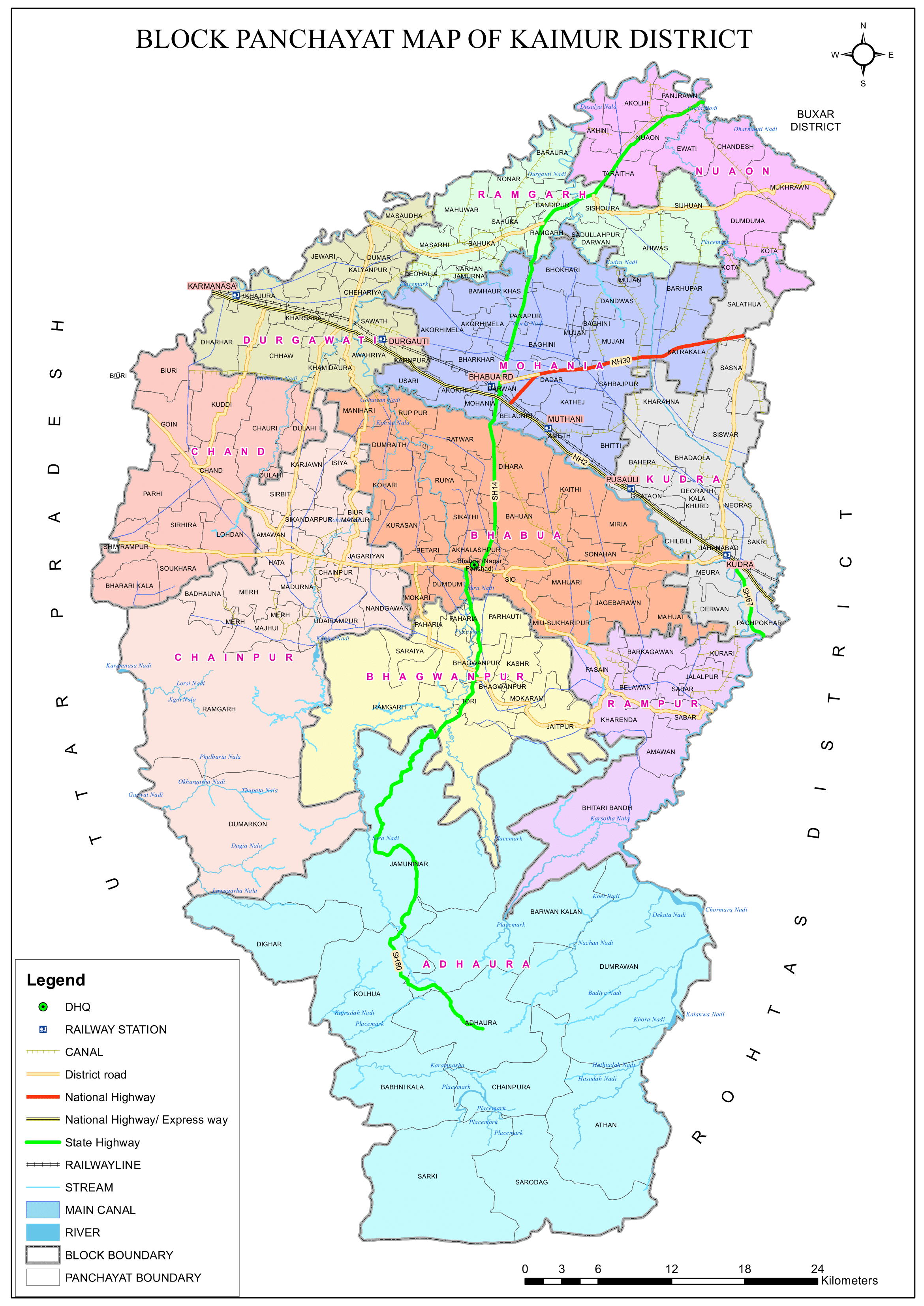
- No. of Sub-Divisions (Tehsils): 2 (Bhabua, Mohania)
- No. of Blocks/Circles: 11
- Adhaura, Bhabua, Bhagwanpur, Chainpur, Chand, Rampur, Durgawati, Kudra, Mohania, Nuaon, Ramgarh
- Gram Panchayats: 146
- No. of Villages: 1700
- Number of Post Offices: 120
- Main Post Office:
- Bhabhua, Near Nagar Parishad Bhabhua, Kaimur – 821101
- Sub Post Office:
- Bhagwanpur, Kaimur- 821102, Phone: 06189-264233
- Mohania, Kaimur- 821109, Phone: 06187-222238
- Ramgarh, Kaimur-821110, Phone: 06187-244222
- Main Post Office:
- Municipal Council (Nagar Parishad): Bhabhua
- Nagar Panchayat: Hata, Kudra, Ramgarh, Mohania
- Police Stations: 17
- Bhabhua, Bhagwanpur, Adhaura, Sonhan, Karamchat, Belaon, Chand, Chainpur, Mohania, Durgawati, Kudra, Ramgarh, Kurdhni, Kucchila, Nuaon, SC/ST Thana, Women Thana
- Vidhan Sabha constituencies:
- Ramgarh, Mohania (SC), Bhabua, Chainpur.
- Key Features:
- The Kaimur Hills and Kaimur Wildlife Sanctuary are prominent attractions.
- Famous for its waterfalls, including Telhar Kund and Karkat Waterfalls.
- Significance: A scenic district with ecological importance.
- Time Zone: UTC+5:30 (IST)
- PIN Code: 8211xx (Kaimur)
- Adhaura- 821102, Bhabhua- 821101, Bhagwanpur- 821102, Chainpur- 821103, Chand- 821106, Durgawati- 821105, Kudra- 821101, Mohania- 821109, Nuaon- 802132, Ramgarh- 821110, Rampur- 821101
- STD Code:
- Adhaura- 06180, Bhabhua- 06189, Bhagwanpur- 06189, Chainpur- 06189, Chand- 06189, Durgawati- 06187, Kudra- 06187, Mohania- 06187, Nuaon- 06187, Ramgarh- 06187, Rampur- 06189
- ISO 3166 Code: IN-BR
- Official Website: kaimur.nic.in
Geography
- Location:
- South-West Bihar, bordering Uttar Pradesh.
- The district’s western-southern point, called Chand, is located on the Bhabua–Chandauli road.
- Bordering Districts:
- North: Buxar district (Bihar) and Ghazipur district (Uttar Pradesh).
- South: Garhwa district (Jharkhand) and Rohtas district (Bihar).
- East: Aurangabad and Rohtas district (Bihar).
- West: Adjacent to Chandauli and Mirzapur districts (Uttar Pradesh).
- Area: Approximately 3,362 square kilometers (1,298 sq mi), equivalent to about 340,447 hectares.
- Geographical Divisions:
- Hilly Area:
- Comprises the Kaimur Plateau (also known as the Rohtas Plateau).
- Plain Area:
- Located on the western side, flanked by the Karmanasa and Durgawati rivers.
- The Kudra River flows along the eastern boundary of the plain area.
- Hilly Area:
- Topography:
- Kaimur Hills – A part of the Vindhya Range.
- Son River – The major river flowing through the district.
- Natural Features & Biodiversity:
- Forest Cover:
- Approximately 106,300 hectares of forest, including the Kaimur Wildlife Sanctuary (home to tigers, leopards, and chinkaras).
- Administration & Local Economy:
- Managed under the forest divisions of Kaimur and Rohtas districts.
- The local villagers are primarily engaged in agriculture.
- Water Bodies & Waterfalls:
- Notable waterfalls such as Karkat Waterfall and Telhar.
- The district has numerous seasonal streams and natural formations typical of a plateaued landscape.
- Forest Cover:
- Climate:
- Summers: Hot and dry (up to 44°C).
- Winters: Pleasant and cool (5°C – 20°C).
- Monsoon: Moderate rainfall, supporting agriculture.
Kaimur Wildlife Sanctuary:
- Overview & Establishment:
- Largest wildlife sanctuary in Bihar, covering 1,504.96 km² (581.07 sq mi).
- Located in the plateaued landscape of the Kaimur Range, spanning parts of Kaimur and Rohtas districts.
- Established in 1979.
- Planned for development into a Tiger Reserve by the Government of Bihar.
- Forest Types & Natural Features:
- Dominant forest types include:
- Tropical Dry Mixed Deciduous Forests
- Dry Sal Forests
- Boswellia Forests
- Dry Bamboo Brakes
- The sanctuary features many seasonal streams and becomes resplendent with greenery during the monsoon and winter seasons.
- Contains several waterfalls, including:
- Karkat Waterfall
- Manjhar Kund
- Dhua Kund
- Tutla Bhawani Waterfall
- Geeta Ghat Waterfall
- Kashish Waterfall
- Telhar
- Dominant forest types include:
- Water Bodies & Infrastructure:
- Home to several dams and lakes, such as:
- Anupam Lake
- Karamchat Dam
- Kohira Dam
- Provides water for irrigation and supports local biodiversity.
- Home to several dams and lakes, such as:
- Fauna & Avifauna:
- Mammals & Reptiles:
- Bengal tigers, Indian leopards, Indian boars, Indian pangolins, sloth bears, sambar deer, Indian muntjacs, four-horned antelopes, chitals, nilgais.
- Various species of reptiles, including cobras, kraits, and occasionally pythons.
- Birdlife:
- Over 70 species of resident birds, including peafowl, grey partridge, quail, Malabar pied hornbill, swallow, nightjar, drongo, paradise flycatcher, kingfisher, bulbul, mynas, pigeons, blue jay, owl, falcon, kites, and several types of eagles (e.g., eastern imperial eagle, greater spotted eagle, white-tailed eagle, Pallas’s fish eagle, grey-headed fish eagle, and lesser kestrel).
- During winter, migratory birds from Central Asia such as the lesser white-fronted goose, ferruginous duck, Baer’s pochard duck, as well as lesser and greater adjutant storks, black-necked stork, and Asian openbill stork, add to the avian diversity.
- Mammals & Reptiles:
- Aquatic Life:
- Fishes are found in Anupam Lake and Kalidah near Rameshwar Kund.
- Archaeological and Cultural Significance:
- The sanctuary area also contains historical sites such as Rohtasgarh Fort and Shergarh Fort.
- Numerous megaliths, prehistoric rock paintings, and stone inscriptions have been discovered in the region.
History
Ancient Period
- Prehistoric rock paintings found in the Kaimur Hills indicate early human settlement.
- The region was part of the Magadh and Mauryan Empires.
- Ashoka’s inscriptions found in nearby districts show Buddhist influence.
Medieval Period
- The region was ruled by the Gupta and Mughal dynasties.
- Sher Shah Suri used the Kaimur hills for military strategies.
British Era & Freedom Struggle
- Kaimur played an important role in the 1857 Revolt.
- Historically linked with Shahabad district; the present Kaimur district was formed from the Bhabua subdivision of the old Shahabad district.
- The region was originally part of Shahabad district before becoming a separate district in 1991.
Current Status
- Kaimur district is part of the Red Corridor due to insurgent activity.
- It is an emerging tourist destination, known for its historical, religious, and archaeological significance.
Cultural & Religious Significance
Kaimur is a significant religious and cultural hub, particularly for Hindus. It is associated with:
- The Penitential Site of Atri Rishi (Attri Muni)
- Maa Mundeshwari Temple – One of the oldest functional temples in India, attracting numerous tourists and pilgrims.
Demographics (As per the 2011 Cencus)
Population:
- Total Population: Kaimur district has a population of approximately 1,626,384 (now estimated at around 1.8 million).
- Males Population: 52.08% (8,47,006)
- Females Population: 47.9% (7,79,378)
- Urban Population: (65,571) 4.03% of the total population lives in urban areas.
- Rural Population: (15,60,813) 95.96% of the total population lives in rural areas.
- Population Ranking: 307th in India (out of 640 districts).
- Density: 488 persons per square kilometer (1,260/sq mi)
- Population Growth (2001–2011): 27.54% reflecting significant population increase.
- Sex Ratio: 919 females per 1,000 males, which is similar to State sex ratio (Ranks 21st out of 38 in Bihar).
Literacy Rate:
- Overall Literacy:
- 71.01% of the total population is literate, higher than Bihar’s average and with significant efforts being made to improve education access and quality.
- 392nd in India (out of 640 districts).
- Gender Disparity:
- Men: 81.49% literacy rate.
- Women: 59.56% literacy rate.
- Urban vs. Rural: Literacy is higher in urban areas compared to rural areas.
Religious Composition (2011 Census):
- The majority of the population follows Hinduism, with a significant Muslim community and other communities forming a significant part.
- Hinduism: 89.54%
- Scheduled Castes: 22.69% of the total population.
- Scheduled Tribes: 3.57% of the total population.
- Islam: 9.55%
- Buddhism: 0.47%
- Other or not stated: 0.44%
- Hinduism: 89.54%
Languages Spoken:
- Bhojpuri: 90.55%
- Hindi: 7.11%
- Urdu: 2.13%
- Others: 0.21%
Administration & E-Governance
- The district is headed by an IAS officer of the rank of District Magistrate (DM).
- District Administrative Headquarters: Bhabua town
- The district is divided into Sub-divisions or Tehsils, and these Tehsils are further divided into Blocks.
Subdivisions:
- The district has 2 revenue subdivisions or Tehsils for administrative convenience: Bhabua and Mohania.
- Each revenue sub-division is headed by a Revenue Divisional Officer (RDO), who functions as the Sub Divisional Magistrate with jurisdiction over that division.
- Each subdivision is led by a Sub-Divisional Magistrate (SDM) who is in charge of development, revenue-related tasks, and maintaining law and order.
- Tahsildars, who are administrative officers in the appropriate cadre, assist in managing the sub-divisional offices.
- The sub-divisional offices are structured similarly to the Collectorate, serving as intermediary administrative units.
- Each sub-division consists of several Blocks, and the performance of these blocks is continuously monitored by the respective Divisional Office.
Blocks and Circles:
- Kaimur district comprises 11 administrative Blocks and Circles under 2 subdivisions are:
- Bhabua: Adhaura, Bhabua, Bhagwanpur, Chainpur, Chand, Rampur
- Mohania: Durgawati, Kudra, Mohania, Nuaon, Ramgarh
- Each block responsible for local governance and development.
- A Circle officer (CO) leads each circle, while a Block Development Officer (BDO) leads each block.
Governance:
- Lok Sabha Constituency:
- Comes under 34-Sasaram and 33-Buxar
- Vidhan Sabha Constituencies: The district has 4 Assembly seats.
- 33-Buxar: – 203-Ramgarh
- 34-Sasaram: – 204-Mohania, 205-Bhabua and 206-Chainpur
Organization Chart

Overall Roles and responsibilities of the Collectorate:
Plays a pivotal role in district administration and Responsible for maintaining law and order, planning, development, revenue, and disaster management within the district.
- Collector (I.A.S Cadre):
- Head of the District: Acts as the chief executive and District Magistrate.
- Law and Order: Maintains peace and enforces law and order in the district.
- Planning & Development: Oversees planning and development projects.
- Administration of Scheduled/Agency Areas: Manages areas designated as scheduled or under special agency administration.
- Election Management & Arms Licensing: Handles general elections and oversees the licensing of arms.
- Additional Collector (B.A.S Cadre):
- Revenue Administration: Runs revenue-related functions across various district departments.
- Additional District Magistrate: Shares responsibilities in maintaining law and order and administering civil functions.
- Key Responsibilities: Oversees civil supplies, land matters, management of mines and minerals, and supervises village officers.
- District Development Commissioner (B.A.S Cadre):
- Developmental Activities: Manages and coordinates various developmental initiatives across the district.
- Key Departments Overseen:
- District Medical and Health Department.
- Social Welfare Department.
- BC (Backward Classes) Welfare and BC Corporation.
- Disabled Welfare.
- Housing and other related departments.
- Additional Collector (Disaster) (B.A.S Cadre):
- Disaster Management: Focuses on planning and coordinating activities related to disaster management.
- Key Responsibilities: Oversees the disaster section and other related developmental departments during emergencies.
These roles collectively ensure that the district is well-governed, with a focus on maintaining law and order, efficient revenue collection, effective disaster management, and sustainable development across various sectors.
NIC District Offices and their roles:
- NIC Overview & National Role:
- Provides nationwide ICT infrastructure to support e-Governance and Digital India initiatives.
- Operates through NIC State Centres in 36 States/UTs and 708 District Centres across the country.
- Key ICT infrastructure includes:
- NICNET and National Knowledge Network (NKN)
- Local Area Networks (LAN)
- Mini Data Centres
- Videoconference Studios
- Messaging and Webcast Facilities
- NIC District Centre Kaimur, Bhabua:
- Established in 1991.
- Has been instrumental in extending ICT services and promoting informatics culture within the district administration.
- Works closely under the guidance of the State Informatics Officer and the District Informatics Officer (DIO).
- Roles & Functions:
- Project Execution:
- Implements various e-Governance and Digital India projects at the grassroots level.
- Technical Support & Consultancy:
- Provides day-to-day ICT-driven technical support to Central, State, and District Government Offices.
- Capacity Building:
- Facilitates training and capacity building for government staff and departments.
- ICT Infrastructure Deployment:
- Ensures connectivity through NICNET and NKN, supports video conferencing, and manages email and SMS services.
- Software Development & VVIP Support:
- Engages in software development and offers technical support during VVIP events and DeitY programmes (e.g., Digital India, CSCs, DISHA, e-Governance Society).
- Project Execution:
- New Initiatives & Collaboration:
- Works with District Magistrates to design and develop new ICT initiatives tailored to local needs.
- Provides technical and consultancy support for the successful execution of e-governance projects.
Economy
- Agriculture-Driven Economy:
- Primary occupation: Over 80% of the population depends on farming.
- Main crops include rice, wheat, telhan, dalhan, maize, sugar cane, oil-seeds, and pulses.
- Fruits like mangoes and guavas are also grown.
- Kaimur is known as the “Rice Bowl of Bihar” due to its extensive rice production.
- Irrigation: Son Canal and tube wells provide water.
- Canal irrigation systems are prominent, supporting large-scale cultivation.
- Rice grown here is sold in major markets such as Kolkata and Delhi.
- Agro-Based Industries:
- Rice polishing is a key industry tied to agricultural production.
- Kaimur town acts as a local trading hub for food grains, agricultural products, and agricultural equipment.
- Industrial Sector:
- The district is scantily industrialized overall.
- Stone mining: The Kaimur Hills are rich in limestone and minerals.
- Brick-making and rice mills contribute to the local economy.
- A few private rice mills operate mainly in the Mohania sub-division.
- Handicrafts and pottery are prominent in some areas.
- Kudra is recognized as an industrial city within Kaimur, featuring:
- 12 large rice mills and 400 mini rice mills.
- Notable industries in the district include:
- Vanaspati Oil Ltd.
- ACC Limited
- The HVDC grid station of the Power Grid Corporation of India at Pusauli.
- Forest-Based Potential:
- The district has a significant forest cover of approximately 1,06,300 hectares, presenting opportunities for forest-based industries.
- Government Support & Economic Challenges:
- In 2006, Kaimur was identified as one of the 250 most backward districts in India.
- It is one of the 36 districts in Bihar receiving funds from the Backward Regions Grant Fund Programme (BRGF).
- Tourism Potential:
- The Mudeshwari Mata Temple in the district has high potential for development into a major religious tourism hub.
Education
Notable Educational Institutions
- Bhabua Degree College.
- Gram Bharati College, Ramgarh
- Government Polytechnic, Kaimur
- Maharana Pratap College, Mohania
- Sardar Ballabh Bhai Patel College, Bhabhua
- Saheed Sanjay Singh Mahila College, Bhabhua
- Manorama Devi Ramrati Patel Degree Women’s College, Bhabhua
- Several government and private colleges affiliated with Veer Kunwar Singh University.
- Some Schools:
- Manava Bharati Heritage School, Vill + PO – Chand, Kaimur- 821106
- DAV Public School, Ratwar, Bhabhua- Mohania Road, Kaimur- 821109
- Town High School, Bhabhua – Chainpur – Chand – Dharuali Rd, Bhabua- 821101
- DAV Public School, Power Grid, Pusauli, P.O.- Bhitti via Mohania Kaimur – 821109
- Children’s Garden School, Near SVP College, Ward No.-5, Bhabua, Kaimur- 821101
- DAV School, Bhabhua – Adhaura Road, Near SVP College, Ward No. 5, Bhabua- 821101
- Jawahar Navodaya Vidyalaya, Vill-Chourasia, Mohania-Ramgarh Road, Post: Jamurna, Kaimur – 821110
Challenges
- Limited higher education institutes – Many students migrate to Varanasi, Patna, and Delhi for studies.
- Need for technical and vocational training centers.
Culture & Festivals
Festivals:
- Chhath Puja:
- The biggest festival in Kaimur, celebrated grandly on the banks of the River.
- A major Hindu festival dedicated to the Sun God (Surya), celebrated with immense faith.
- Held twice a year:
- In Chaitra (summer)
- In Kartik (beginning of winter)
- Devotees observe rigorous rituals including holy bathing, fasting, and offering water (arghya) to the setting and rising sun.
- Makar Sankranti (Tila Sankranti):
- Celebrated at the beginning of summer and marks the harvest season.
- Considered auspicious as it symbolizes the commencement of a new year in Indian culture.
- Holi:
- One of the biggest and most colorful festivals in the district.
- Celebrated with great enthusiasm, where people engage in joyous, vibrant festivities that light up the atmosphere.
- Durga Puja, Diwali, Janamashtami, Kali Pooja, Sarswati Pooja, Nag Panchemi, Shiv Ratri, Bakarid, Eid and Muharram are also widely celebrated.
- Bhojpuri Folk songs and dances are a major part of the cultural identity.
Cuisines:
- Traditional Staples:
- Daily meals typically include dishes such as sabzi (vegetable curry), roti (flatbread), dal (lentils), and bhaji (stir-fried vegetables).
- Signature Dishes:
- Litti Chokha: A popular Bihari delicacy made with roasted wheat balls (litti) served with mashed vegetables (chokha).
- Kadhi: A yogurt-based curry often spiced with traditional seasonings.
- Jhal Moori: A spicy snack mix, beloved by locals.
- Roasted gram flour, used in various dishes and beverages like Sattu Paratha, Dal Pitha and Dal Puri.
- Kachauri-Sabzi are commonly eaten.
- Sweets & Desserts:
- Renowned for its mouthwatering sweets made with pure desi ghee, which are available in local sweet shops and are commonly prepared at home during ceremonial occasions.
- Sweets like Khaja, Balushahi, Tilkut, Khurma, Thekua and Malpua are famous.
Costumes:
- Traditional Male Attire:
- Dhotis, kurtas, and pajamas are commonly worn.
- Young men may also be seen in shirts and trousers, blending traditional and modern styles.
- Traditional Female Attire:
- Women traditionally wear Ghaghara (long skirts), choli (blouses) and Saree, reflecting the rich Hindu cultural heritage.
- Attire of the Muslim Community:
- Men: Typically dress in kurta and pajama.
- Women: Often wear burkas, following traditional Muslim attire.
Religions:
- Religious Composition:
- The district is predominantly Hindu, but it also has a significant Muslim community.
- Tribal communities also reside under the district, with many adhering to their own indigenous religious practices.
- Cultural Integration:
- The region’s cultural landscape is a vibrant mix of various religious traditions, with communities having coexisted for many decades.
- Social Harmony:
- Despite the diversity, there is a strong sense of social unity and hospitality, which leaves a lasting impression on visitors.
- Heritage and Tradition:
- The rich tapestry of religious traditions contributes to a unique cultural heritage, which is evident in festivals, rituals, and everyday practices.
Tourism & Historical Places
Kaimur is rich in heritage and natural beauty, attracting tourists from Bihar and neighboring states.
Major Attractions
- Kaimur Wildlife Sanctuary – Bihar’s largest wildlife sanctuary, home to leopards, tigers, deer, and birds.
- Tutla Bhawani Waterfall & Temple – A famous Hindu pilgrimage site with a scenic waterfall.
- Mundeshwari Temple – One of the oldest Hindu temples in India (4th century), dedicated to Shiva and Shakti.
- Sidhanath Temple, Chainpur – A sacred site for Lord Shiva devotees.
- Shergarh Fort – A historic fort with ancient ruins and stunning views.
- Bhagwanpur Rock Paintings – Prehistoric cave paintings over 20,000 years old.
1. Maa Mundeshwari Temple (Bhagwanpur):
- Known as the “oldest functional temple in the world”.
- Location & Setting:
- Located in Ramgarh village within the Bhagwanpur block of Bhabua Subdivision.
- Located about 10 km south of Bhabua and approximately 25 km south of Bhabua Road Railway Station.
- Situated on the summit of Piwara hill at a height of approximately 600 feet.
- Historical & Archaeological Significance:
- Inscriptions suggest the temple dates back to around 635 A.D.
- An older inscription from around 389 A.D. indicates its ancestral origins.
- Visited by British travelers R. N. Martin, Francis Buchanan, and Block between 1812 and 1904.
- Stone carvings and architectural features belong to the Gupta period.
- Architectural Features:
- The temple is octagonal in shape and constructed entirely of stone.
- Contains four entrances:
- One entrance is closed, and one is half-open.
- A unique Panchmukhi Shivaling is installed in the central part:
- Made from a special stone that changes color with the sun’s position.
- The eastern section houses the grand and ancient idol of Goddess Mundeshwari:
- Depicted in the form of Vaarahi, with Mahish (buffalo) as her vehicle.
- A statue of Vishal Nandi adorns the west side of the main entrance.
- Cultural & Ritual Aspects:
- Renowned for its unique ritual of animal (goat) sacrifice:
- The goat is sacrificed but not slaughtered, a practice not found elsewhere.
- Renowned for its unique ritual of animal (goat) sacrifice:
- To visit the temple, travelers can:
- Arrive at Bhabua Road station and take a direct bus to the temple, or
- Take a bus to Bhabua and then an auto or tempo from there.
- Additional Information:
- For more details, visit the temple website: Maa Mundeshwari Trust
2. Harsu Brahma Temple (Chainpur):
- Location & Accessibility:
- Harsu Brahma Temple is located about 10 km southwest of the district headquarters in Bhabua, on the Bhabua–Chainpur Road.
- Chainpur itself is situated about 11 km west of Bhabua headquarters.
- Historical & Architectural Significance:
- The temple complex includes the Harsu Brahma Samadhi, located within a large fort believed to be associated with Raja Sharivahan.
- The fort and temple area are steeped in local legends and are revered for their spiritual significance.
- Cultural Beliefs & Legends of Chainpur:
- Devotees, both indigenous and foreign, believe that visiting this site helps them overcome various phantom obstructions.
- In Chainpur, the area is credited with a mausoleum of Bakhtiar Khan, who is said to have married the daughter of Sher Shah.
- The fort at Chainpur dates back to the Suri or Akbar period.
- The Hindu shrine of “Harsu Brahm” is well-known in the locality.
- According to legend, a priest named Harshu Pandey (a priest of Raja Sharivahan) ended his life in protest against the demolition of his house, and during his cremation, he was miraculously seen standing at the cremation site in Varanasi.
3. Baidyanath Temple (Deohalia, Ramgarh) and related sites:
- Architectural Features:
- A Shiva temple with an octagonal base and shikhar (tower), resembling the Kendaria Mahadev temple of Khajuraho.
- Features a unique “womb house” carved from a single rock, exemplifying fine craft art.
- Historical Background:
- Believed to have been built in the 11th century by Chandel Raja Vidyadhar Dhang.
- Raja Vidyadhar Dhang also constructed four ponds (kunds) at the four corners of the temple:
- Dhruv Kund
- Rudra Kund
- Brahma Kund
- Vishnu Kund
- Only two of these ponds exist today.
- Religious Significance & Cultural Role:
- A revered jagrath dharmasthal (active center of worship) that has attracted tens of thousands of devotees over the centuries.
- During the month of Saawan, a large fair is organized, drawing pilgrims from Bihar, Uttar Pradesh, and Jharkhand who come to perform Jalabhishek (water offering) to Lord Shiva.
- Location & Accessibility:
- Approximately 26 km from the Bhabhua headquarters.
- About 12 km from the Bhabhua Road railway station (Mohania).
- Additional Site – Baidyanath Village:
- Located 9 km south of the Ramgarh block headquarters.
- Contains another Shiva temple built by the late Pratihar dynasty.
- Historical coins and other valuable artifacts have been unearthed from this site, adding to its archaeological significance.
4. Telhar Kund / Waterfall (Adhaura):
- Location & Elevation:
- Situated in the Kaimur mountain range on the Kaimur plateau.
- Located 58 km from Bhabua.
- Positioned at an elevation of 2,000 feet above sea level.
- Located near the origins of the Durgavati River and only a few kilometers from the Durgavati reservoir project.
- Waterfall Characteristics:
- The waterfall, known as Telhar Pond Waterfall, is approximately 80 meters high.
- It offers a thrilling view as water cascades from a significant height.
- The water remains cool throughout the year, irrespective of the season.
- Water Source & Energy Potential:
- The main water source is a golden river derived from Kharga (Dumbur).
- Water from numerous small rainy hills is collected into the Kund.
- A survey by the National Hydro Electric Power Corporation estimates that the water flow could potentially generate 60 MW of power.
- Surrounding Environment:
- Located amidst the lush forests of the Kaimur hills.
- The area features several other scenic waterfalls, including Tutla Bhavani Waterfall, Kashish Waterfall, and Manjhar Kund.
- The natural greenery becomes especially vibrant during the rainy season.
- Tourist Appeal:
- The surrounding hills and forests create a picturesque and natural environment.
- The site is ideal for nature lovers and adventure tourists looking to experience scenic beauty and waterfall views.
5. Mother Chherwari Dham:
- Historical Background:
- Tradition holds that in the 15th century, the Rathore dynasty from Chittorgarh and Mewar established the statue of their Kuldevi (family goddess) in the Mahuar village desert.
- Deity & Form:
- The goddess is revered in the form of Sherawali.
- Cultural Significance:
- A major pilgrimage site, especially during Navaratri when large crowds gather for worship.
6. Peer Baba’s Mazar:
- Location:
- Situated in the village of Pathar in the Chand Block.
- Attraction:
- Famous for its pleasant ambiance and scenic beauty.
- Local Belief:
- Devotees believe that performing a specific ritual here (such as offering or growing a sheet) results in the fulfillment of their desires.
7. Chandeshwari Dham (Madurana, Chainpur):
- Location:
- Located on the southern Madurana hill in the Chainpur area.
- Historical & Mythological Significance:
- Known as Chandeshwari Dham Sidhpith; associated with the legend of Chand and his wife.
- The name is linked to a historical figure (Chand’s wife, believed to be named Chand Chand or Madan), with the area now known as Madurana village.
- Accessibility:
- Easily reachable due to its proximity to Bhabua headquarters and the Mudeshwari temple.
8. Kuleswari Dham (Kulhadia, Durgavati):
- Community Association:
- Popular among the Nagvanshi Rajputa community, settled in about 105 villages across Bihar and Uttar Pradesh.
- Annual Fair:
- Hosts a 15-day grand fair during Chaitra Navaratri, renowned for wood and stone handicrafts as well as traditional nautanki (folk theatre).
- Location:
- Situated in Kulhardia within the Durgavati region, approximately 26 km from Bhabua headquarters.
9. Bakhtiar Khan’s Rouza (Chainpur):
- Historical Context:
- A mausoleum dating from the 16th-17th century, built in memory of Bakhtiar Khan.
- Architecture:
- Features an octagonal design with an outer diameter of about 42 meters.
- Overall dimensions of the structure are approximately 88 x 70 meters.
- Includes a verandah with 24 small domes on the roof.
- Location & Connectivity:
- Located on the banks of the Kuah River in Chainpur.
- Situated about 18 km from Mudeshwari temple and 1 km from Harshu Brahama temple.
- Tourist Experience:
- Part of a heritage tour in the area, reflecting the region’s rich history.
10. Karkat Waterfall (Chainpur):
- Location & Setting:
- Situated in Karkatgarh Village, within the Kaimur mountain range of Kaimur district, Bihar.
- Located on the Karmanasa River.
- Natural Habitat & Eco-Tourism:
- Known for its picturesque waterfall and scenic natural environment.
- Recognized as a natural habitat for crocodiles.
- The Government of Bihar is developing the site as a Crocodile Conservation Reserve and an eco-tourism destination.
- Historical Background:
- Historically, the waterfall was a popular crocodile hunting spot for Mughal rulers and British officials.
- A dak bungalow was constructed by British officials to enjoy the view of the waterfall.
- British official Henry Ramsay described it as the finest fall surrounded by beautiful sceneries.
- The waterfall measures approximately 300 feet in width and 100 feet in height.
- Currently, the waterfall is part of the Kaimur Wildlife Sanctuary (established in 1979) where hunting is prohibited.
- Conservation Initiatives:
- The initiative for a Crocodile Conservation Reserve was spurred after at least 75 crocodiles were spotted at the site.
- In 2016, the Government of Bihar sanctioned Rs 3 lakh as seed money for a preliminary study.
- Crocodile experts submitted a plan proposal to the central government for further funding.
- In 2018, the Union Minister of Forests and Environment sanctioned an additional Rs 3 lakh for expert assessment, data collection, and micro plan preparation.
- The Wildlife Institute of India has hired researchers to conduct behavior studies and data collection.
- Planned conservation measures include creating natural conditions in two test ponds to support breeding, where female crocodiles will be housed for egg-laying and rearing their young.
11. Bhagwanpur:
- Location & History:
- Located 11 km south of Bhabua near the Kaimur hills.
- Historically the seat of power of Kumar Chandrasen Saran Singh, who claimed descent from Paras.
- Historical Transitions:
- Initially ruled by Raja Shaliwahan, later confiscated by Sher Shah, and eventually restored to his successor during Akbar’s reign.
Transportation
Roadways
- National Highways: Well-connected to Patna, Varanasi, and other cities.
- NH 19 (Grand Trunk Road):
- Crosses through Mohania Town, Pusauli, and Kudra.
- NH 319:
- Originates from Mohania and connects to the capital Patna via Arrah.
- NH 2 (G.T. Road):
- Also runs through Mohania Town.
- NH 30: pass through Kaimur.
- Also originates from Mohania and connects with Patna via Arrah.
- NH 19 (Grand Trunk Road):
- State Highways:
- State Highway 14:
- Connects Bhabua (district headquarters) to Mohania.
- State Highway 14:
- Local Connectivity:
- Mohania is well connected to:
- Buxar via Ramgarh (to the south).
- Bhabua (including Adhaura, Bhagwanpur) also via southern routes.
- Mohania is well connected to:
Railways
- Mohania (Bhabua Road) Junction – A major railway station on the Delhi-Howrah route.
- Other stations: Kudra, Durgavati, Pusauli.
- Bhabua Road Railway Station:
- Located in Mohania Town on the Gaya–Mughalsarai section of the Grand Chord Railway line.
- Bhabua (the district headquarters) is about 14 km south of this station.
Airways
- Nearest Airport:
- Lal Bahadur Shastri International Airport (Varanasi Airport–VNS) in Babatpur, Varanasi – (100 km).
- Patna Airport (180 km).
Notable personalities from Kaimur District
1. Manoj Kumar Tiwari:
- Basic Information:
- Name: Manoj Kumar Tiwari
- Date of Birth: 1 February 1971
- Birthplace: Kabir Chaura locality, Varanasi, Uttar Pradesh
- Family Roots: Hails from Atarwalia, a small village in Kaimur district, Bihar
- Education: Completed M.P.Ed. from Banaras Hindu University
- Career in Arts:
- Worked as a singer and actor in the Bhojpuri film industry before entering politics
- Political Career:
- 2009 General Elections:
- Contested as a Samajwadi Party candidate from Gorakhpur Lok Sabha but lost to Yogi Adityanath
- 2014 General Elections:
- Contested as a Bharatiya Janata Party (BJP) candidate and won, becoming a Member of Parliament from North East Delhi (serving since 2014)
- Leadership Roles:
- Appointed as Delhi BJP president in 2016
- Led the BJP organization in Delhi during the record victory in the 2017 MCD elections
- 2009 General Elections:
- Personal Life:
- First Marriage:
- Married Rani Tiwari in 1999; they have a daughter named Rhiti
- Underwent divorce proceedings in 2011 and finalized the divorce in 2012
- Second Marriage:
- Married Surbhi; they have two daughters, born on 30 December 2020 and 12 December 2022
- First Marriage:
2. Gopal Prasad Sinha:
- Profession & Background:
- Indian neurologist and politician.
- Member of the Institutional Ethical Committee of the Indian Council of Medical Research.
- Born and brought up in Patna; alumnus of Patna University.
- Political Involvement:
- Contested the 2014 Indian Parliament elections from the Patna Sahib constituency under Janata Dal (United) but was unsuccessful against Shatrughan Sinha.
- Family & Recognition:
- Married to the late Indira Sinha, an educationist.
- Has a daughter, Jaya Sinha Kumra, and a son, Ajay Alok, a noted politician from Bihar.
- Awarded the Padma Shri in 2004 for his services in the field of medicine.
3. Lalmuni Chaubey:
- Personal Information:
- Born on 6 September 1942 and passed away on 25 March 2016.
- Political Career:
- Member of the 14th Lok Sabha, representing the Buxar constituency as a member of the Bharatiya Janata Party (BJP) for four consecutive terms.
- Earlier served as a member of the Bihar Legislative Assembly from 1972.
- Legacy:
- Remembered for his long-standing contribution to parliamentary and state-level politics.
- Died at AIIMS in Delhi.
4. Mahabali Singh:
- Basic Information:
- Full Name: Mahabali Singh Kushwaha.
- Born on 20 April 1955 in Khiri village, Bhagwanpur District, Kaimur.
- Political Journey:
- Twice represented the Chainpur seat in the Bihar Legislative Assembly:
- Initially as a member of the Bahujan Samaj Party (BSP).
- Later defected to Rashtriya Janata Dal (RJD) and served as PWD Minister in the Rabri Devi government in 2002.
- Joined Janata Dal (United) and subsequently:
- Won the Chainpur seat in the 2005 and 2010 assembly elections.
- Elected to the 15th Lok Sabha from the Karakat parliamentary constituency in 2009, lost in 2014, and regained the seat in 2019.
- Twice represented the Chainpur seat in the Bihar Legislative Assembly:
- Additional Roles & Contributions:
- Served as a Cabinet Minister in Bihar (PWD, Food & Civil Supplies).
- Held membership in key Lok Sabha committees including Defence, Ethics, and Power.
- Advocated for caste-based population enumeration, supporting the Bihar Caste Survey 2022.
- Also engaged in publishing platforms focused on Gautam Buddha, Ambedkar, and Jagdev Vichar Manch.
- Enjoys football, cricket, and folk dramas.
5. Brij Kishor Bind:
- Professional Background:
- Indian politician affiliated with the Bharatiya Janata Party (BJP).
- Political Career:
- Former cabinet minister in the Government of Bihar for the Mines, Geology, and Backward & EBC Welfare departments.
- Elected three times as an MLA from the Chainpur constituency in Kaimur district.
- Community Affiliation:
- Belongs to the Bind caste.
- Unique Perspective:
- Has noted that, according to the Shiva Purana, Lord Shiva has been described as belonging to the Bind caste.
6. Mohd Zama Khan:
- Political Profile:
- Indian politician from Kaimur district.
- Currently a member of the Bihar Legislative Assembly.
- Electoral Achievements:
- Won the Chainpur seat in the 2020 Bihar Legislative Assembly election on a Bahujan Samaj Party ticket with a margin of nearly 35,000 votes.
- Party Transition & Current Role:
- Later switched to Janata Dal (United).
- Appointed as the Minister of Minority Affairs in the Seventh Nitish Kumar ministry.
Challenges & Issues
- Illegal stone mining – Causes environmental degradation.
- Limited industrial growth – Few job opportunities beyond agriculture.
- Need for better education and healthcare.
- Floods and droughts – Affect farming communities.
- Unemployment – Many migrate to metro cities for work.
Conclusion
Kaimur is a historically, culturally, and environmentally significant district of Bihar. With its rich natural resources, agriculture-based economy, and growing tourism potential, it has the capacity for economic development. Investments in education, industries, and infrastructure can help Kaimur emerge as an important hub in Bihar’s future growth.
Would you like more details about any specific Topics on Bihar? Comment Below 😊
कैमूर जिला: प्रकृति, पहाड़ियों और इतिहास की एक विशेष भूमि
अवलोकन
कैमूर जिला भारत के बिहार राज्य के दक्षिणी-पश्चिमी भाग में स्थित 38-जिलों में से एक है। अपनी प्राकृतिक सुंदरता, समृद्ध ऐतिहासिक और सांस्कृतिक विरासत और कृषि महत्व के लिए जाना जाता है। इसका नाम कैमूर पहाड़ियों के नाम पर रखा गया है, जो विंध्य पर्वतमाला का हिस्सा हैं और इस क्षेत्र के परिदृश्य और जैव विविधता को आकार देने में महत्वपूर्ण भूमिका निभाते हैं। यह जिला कैमूर वन्यजीव अभयारण्य, प्रागैतिहासिक शैल चित्रों और उपजाऊ भूमि का भी घर है, जो इसे बिहार की सांस्कृतिक और पारिस्थितिक विरासत का एक महत्वपूर्ण हिस्सा बनाता है।
3,362 वर्ग किलोमीटर (1,298 वर्ग मील) के क्षेत्र में फैला, कैमूर बिहार के कुल भूमि क्षेत्र का 4% हिस्सा है, जो इसे राज्य का चौथा सबसे बड़ा जिला बनाता है। रोहतास 24°30” से 25°20” उत्तरी अक्षांश और 83°14” से 83°20” पूर्वी देशांतर पर स्थित है और उत्तर में उत्तर प्रदेश के बक्सर जिले और गाजीपुर जिले, दक्षिण में झारखंड के गढ़वा जिले और रोहतास जिले, पूर्व में औरंगाबाद जिले और रोहतास जिले और पश्चिम में उत्तर प्रदेश के चंदौली जिले और मिर्जापुर जिले से सटा हुआ है। जिले का प्रशासनिक मुख्यालय भभुआ टाउन में स्थित है। जिला पटना डिवीजन का हिस्सा है।
ऐतिहासिक रूप से, 1764 तक, यह गाजीपुर जिले के अंतर्गत था और कामसार राज का एक हिस्सा था। बाद में, यह 1837 तक चैनपुर एस्टेट के अंतर्गत आया। 1991 से पहले, कैमूर रोहतास जिले का एक हिस्सा था शुरुआत में इसे भभुआ जिला कहा जाता था, लेकिन 1994 में इसका नाम बदलकर कैमूर कर दिया गया।
प्राचीन इतिहास
कैमूर प्रागैतिहासिक काल से ही बसा हुआ है, खासकर इसके पठारी क्षेत्र में, जो भर, चेरो और सवेर जैसी आदिवासी जनजातियों का घर था। कुछ किंवदंतियों में यह भी उल्लेख है कि खरवार रोहतास के पहाड़ी इलाकों में मूल निवासी थे। ओरांव रोहतास से पटना तक फैले क्षेत्र पर शासन करने का दावा करते हैं।
जिले में मानव निवास का सबसे पहला सबूत लेहड़ा जंगल में शैल चित्रों में मिलता है, जो 20,000 साल पहले के हैं। इसके अतिरिक्त, जून 2012 में, बैद्यनाथ गाँव में कामुक पाल मूर्तियों की खुदाई की गई थी।
यह जिला कभी मगध साम्राज्य (6वीं शताब्दी ईसा पूर्व से 5वीं शताब्दी ईस्वी) का हिस्सा था, जिस पर मौर्यों और गुप्तों का शासन था। 7वीं शताब्दी ई. के दौरान यह कन्नौज के शासक हर्ष के नियंत्रण में आ गया। भभुआ के पास मुंडेश्वरी मंदिर में एक शिलालेख में राजा उदयसेन को इस क्षेत्र का शासक बताया गया है।
मध्यकालीन इतिहास
इस क्षेत्र का कई शासक राजवंशों से गहरा संबंध है, जिसमें मध्य भारत का शैल वंश और बंगाल का पाल वंश शामिल है। सासाराम के पास ताराचंडी शिलालेख इस बात की पुष्टि करता है कि 12वीं शताब्दी में चंदौली ने वाराणसी-चंदौली और कैमूर क्षेत्र को नियंत्रित किया था।
गुप्तों के पतन के बाद, यह क्षेत्र संभवतः आदिवासी जनजातियों और स्थानीय सरदारों के नियंत्रण में आ गया। हालाँकि, उज्जैन और मालवा के राजपूतों ने आदिवासियों के साथ संघर्ष किया और धीरे-धीरे कई शताब्दियों तक इस क्षेत्र पर अपना प्रभुत्व स्थापित किया।
1193 ई. में, बख्तियार खिलजी ने बिहार पर आक्रमण किया और शाहाबाद (जिसमें वर्तमान कैमूर भी शामिल था) को विभाजित राजपूत शासन के अधीन पाया। इन राजपूत सरदारों के बीच एकता की कमी के कारण उन्हें आसानी से इस क्षेत्र पर विजय प्राप्त करने का मौका मिला, जो बाद में जौनपुर राज्य का हिस्सा बन गया। अंततः कैमूर दिल्ली सल्तनत के सीधे नियंत्रण में आ गया।
मुगल काल और ब्रिटिश शासन
- शेर शाह सूरी के पिता हसन खान सूर को सासाराम की जागीर मिली थी, जिसमें कैमूर के कुछ हिस्से शामिल थे।
- 1529 में, बाबर ने इस क्षेत्र पर आक्रमण किया, और अपने संस्मरणों में कर्मनाशा नदी के बारे में हिंदू अंधविश्वासों का दस्तावेजीकरण किया।
- 1537 में, इस क्षेत्र ने चौसा में हुमायूं और शेर शाह सूरी के बीच संघर्ष देखा, जिसके कारण शेर शाह सत्ता में आए।
- अकबर के शासन में, कैमूर को मुगल साम्राज्य में शामिल कर लिया गया था।
18वीं शताब्दी के दौरान, शाह आलम ने ब्रिटिश ईस्ट इंडिया कंपनी के साथ अपने संघर्ष में, दुर्गावती में शरण ली और स्थानीय ज़मींदार पहलवान सिंह के समर्थन से कर्मनाशा नदी को पार किया। हालाँकि, उन्हें अंततः ब्रिटिश मांगों का पालन करना पड़ा।
1764 में, इस क्षेत्र ने बक्सर की लड़ाई देखी, जहाँ अंग्रेजों ने सिराजुद्दौला को हराकर अपना पूर्ण नियंत्रण स्थापित किया। इस क्षेत्र ने बनारस के राजा चैत सिंह के विद्रोह में भी भूमिका निभाई थी, लेकिन अंग्रेजों ने अंततः विद्रोह को दबा दिया।
1857 के विद्रोह और भारतीय स्वतंत्रता आंदोलन में भूमिका
कुंवर सिंह के नेतृत्व में 1857 के विद्रोह ने इस क्षेत्र पर महत्वपूर्ण प्रभाव डाला, जिससे स्थानीय विद्रोह प्रेरित हुए। भारतीय स्वतंत्रता आंदोलन के दौरान, कैमूर ने स्वतंत्रता के संघर्ष में महत्वपूर्ण योगदान दिया।
भारत की स्वतंत्रता के बाद, यह जिला 1972 तक शाहाबाद जिले का हिस्सा रहा, जब रोहतास को अलग कर दिया गया। अंत में, 1991 में, कैमूर जिले की आधिकारिक रूप से स्थापना की गई।
कैमूर जिले के बारे में मुख्य तथ्य
- देश: भारत
- राज्य: बिहार
- प्रमंडल: पटना
- स्थापना: 17 मार्च 1991
- क्षेत्रफल: 3,332 km2 (1,286.5 वर्ग मील)
- ग्रामीण क्षेत्र: 3319.55 km2 (1,281.7 वर्ग मील)
- शहरी क्षेत्र: 12.45 km2 (4.8070 वर्ग मील)
- निर्देशांक: 25°2′26.13″N 83°36′44.67″E
- जिला मुख्यालय: भभुआ
- जिला मजिस्ट्रेट: श्री सावन कुमार, IAS
- पुलिस अधीक्षक: हरि मोहन शुक्ला, IPS
- मंडल वन अधिकारी: चंचल प्रकाशम, IFS
- जनसंख्या:
- कुल: 1,626,384
- घनत्व: 488/km2 (1,260/वर्ग मील)
- साक्षरता दर: 69.34%
- लिंगानुपात: 919/1000
- उप-प्रभागों (तहसीलों) की संख्या: 2 (भभुआ, मोहनिया)
- ब्लॉक/सर्कल की संख्या: 11
- अधौरा, भभुआ, भगवानपुर, चैनपुर, चांद, रामपुर, दुर्गावती, कुदरा, मोहनिया, नुआंव, रामगढ़
- ग्राम पंचायतें: 146
- गांवों की संख्या: 1700
- डाकघरों की संख्या: 120
- मुख्य डाकघर:
- भभुआ, नगर परिषद भभुआ के पास, कैमूर – 821101
- उप डाकघर:
- भगवानपुर, कैमूर- 821102, फ़ोन: 06189-264233
- मोहनिया, कैमूर- 821109, फ़ोन: 06187-222238
- रामगढ़, कैमूर-821110, फोन: 06187-244222
- मुख्य डाकघर:
- नगर परिषद: भभुआ
- नगर पंचायत: हाता, कुदरा, रामगढ़, मोहनिया
- पुलिस स्टेशन: 17
- भभुआ, भगवानपुर, अधौरा, सोनहन, करमचट, बेलांव, चांद, चैनपुर, मोहनिया, दुर्गावती, कुदरा, रामगढ़, कुढ़नी, कुच्छिला, नुआंव, एससी/एसटी थाना, महिला थाना
- विधान सभा क्षेत्र:
- रामगढ़, मोहनिया (एससी), भभुआ, चैनपुर
- प्रमुख विशेषताऐं:
- कैमूर पहाड़ियाँ और कैमूर वन्यजीव अभयारण्य प्रमुख आकर्षण हैं।
- तेलहर कुंड और करकट झरने सहित अपने झरनों के लिए प्रसिद्ध है।
- महत्व: पारिस्थितिक महत्व वाला एक सुंदर जिला। समय क्षेत्र: UTC+5:30 (IST)
- पिन कोड: 8211xx (कैमूर)
- अधौरा- 821102, भभुआ- 821101, भगवानपुर- 821102, चैनपुर- 821103, चांद- 821106, दुर्गावती- 821105, कुदरा- 821101, मोहनिया- 821109, नुआंव- 802132, रामगढ़- 821110, रामपुर- 821101
- एसटीडी कोड:
- अधौरा- 06180, भभुआ- 06189, भगवानपुर- 06189, चैनपुर- 06189, चांद- 06189, दुर्गावती- 06187, कुदरा- 06187, मोहनिया- 06187, नुआंव- 06187, रामगढ़- 06187, रामपुर- 06189
- आईएसओ 3166 कोड: IN-BR
- आधिकारिक वेबसाइट: kaimur.nic.in
भूगोल
- स्थान:
- दक्षिण-पश्चिम बिहार, उत्तर प्रदेश की सीमा से लगा हुआ।
- जिले का पश्चिमी-दक्षिणी बिंदु, जिसे चांद कहा जाता है, भभुआ-चंदौली मार्ग पर स्थित है।
- सीमावर्ती जिले:
- उत्तर: बक्सर जिला (बिहार) और गाजीपुर जिला (उत्तर प्रदेश)।
- दक्षिण: गढ़वा जिला (झारखंड) और रोहतास जिला (बिहार)।
- पूर्व: औरंगाबाद और रोहतास जिला (बिहार)।
- पश्चिम: चंदौली और मिर्जापुर जिलों (उत्तर प्रदेश) से सटा हुआ।
- क्षेत्रफल: लगभग 3,362 वर्ग किलोमीटर (1,298 वर्ग मील), जो लगभग 340,447 हेक्टेयर के बराबर है।
- भौगोलिक विभाजन:
- पहाड़ी क्षेत्र:
- कैमूर पठार (जिसे रोहतास पठार भी कहा जाता है) शामिल है।
- मैदानी क्षेत्र:
- पश्चिमी भाग में स्थित, कर्मनाशा और दुर्गावती नदियों से घिरा हुआ।
- कुदरा नदी मैदानी क्षेत्र की पूर्वी सीमा पर बहती है।
- पहाड़ी क्षेत्र:
- स्थलाकृति:
- कैमूर पहाड़ियाँ – विंध्य पर्वतमाला का एक भाग।
- सोन नदी – जिले से होकर बहने वाली प्रमुख नदी।
- प्राकृतिक विशेषताएँ और जैव विविधता:
- वन क्षेत्र:
- कैमूर वन्यजीव अभयारण्य (बाघ, तेंदुए और चिंकारा का घर) सहित लगभग 106,300 हेक्टेयर वन।
- प्रशासन और स्थानीय अर्थव्यवस्था:
- कैमूर और रोहतास जिलों के वन प्रभागों के अंतर्गत प्रबंधित।
- स्थानीय ग्रामीण मुख्य रूप से कृषि में लगे हुए हैं।
- जल निकाय और झरने:
- करकट झरना और तेलहर जैसे उल्लेखनीय झरने।
- जिले में कई मौसमी धाराएँ और पठारी परिदृश्य की विशिष्ट प्राकृतिक संरचनाएँ हैं।
- वन क्षेत्र:
- जलवायु:
- ग्रीष्मकाल: गर्म और शुष्क (44 डिग्री सेल्सियस तक)।
- सर्दियाँ: सुखद और ठंडी (5 डिग्री सेल्सियस – 20 डिग्री सेल्सियस)।
- मानसून: मध्यम वर्षा, कृषि को बढ़ावा।
कैमूर वन्यजीव अभयारण्य:
अवलोकन और स्थापना:
- बिहार का सबसे बड़ा वन्यजीव अभयारण्य, 1,504.96 वर्ग किमी (581.07 वर्ग मील) में फैला हुआ है।
- कैमूर रेंज के पठारी परिदृश्य में स्थित, कैमूर और रोहतास जिलों के कुछ हिस्सों में फैला हुआ है।
- 1979 में स्थापित।
- बिहार सरकार द्वारा टाइगर रिजर्व के रूप में विकास की योजना बनाई गई।
वन प्रकार और प्राकृतिक विशेषताएँ:
- प्रमुख वन प्रकारों में शामिल हैं:
- उष्णकटिबंधीय शुष्क मिश्रित पर्णपाती वन
- शुष्क साल वन
- बोसवेलिया वन
- शुष्क बांस ब्रेक
- अभयारण्य में कई मौसमी धाराएँ हैं और मानसून और सर्दियों के मौसम में हरियाली से जगमगा उठता है।
- इसमें कई झरने हैं, जिनमें शामिल हैं:
- करकट झरना
- मंझर कुंड
- धुआ कुंड
- तुतला भवानी झरना
- गीता घाट झरना
- कशिश झरना
- तेलहर
जल निकाय और बुनियादी ढाँचा:
- कई बाँधों और झीलों का घर, जैसे:
- अनुपम झील
- करमचट बाँध
- कोहिरा बाँध
- सिंचाई के लिए पानी उपलब्ध कराता है और स्थानीय जैव विविधता का समर्थन करता है।
जीव-जंतु और पक्षी:
- स्तनधारी और सरीसृप:
- बंगाल के बाघ, भारतीय तेंदुए, भारतीय सूअर, भारतीय पैंगोलिन, सुस्त भालू, सांभर हिरण, भारतीय मुंटजैक, चार सींग वाले मृग, चीतल, नीलगाय।
- कोबरा, क्रेट और कभी-कभी अजगर सहित सरीसृपों की विभिन्न प्रजातियाँ।
- पक्षी जीवन:
- निवासी पक्षियों की 70 से अधिक प्रजातियाँ, जिनमें मोर, ग्रे पार्ट्रिज, बटेर, मालाबार पाइड हॉर्नबिल, निगल, नाइटजर, ड्रोंगो, पैराडाइज फ्लाईकैचर, किंगफिशर, बुलबुल, मैना, कबूतर, ब्लू जे, उल्लू, बाज़, पतंग और कई प्रकार के चील (जैसे, पूर्वी शाही चील, बड़ा चित्तीदार चील, सफेद पूंछ वाला चील, पलास का मछली चील, ग्रे-हेडेड फिश ईगल और छोटा केस्ट्रेल) शामिल हैं।
- सर्दियों के दौरान, मध्य एशिया से प्रवासी पक्षी जैसे कि लेसर व्हाइट-फ्रंटेड गूज, फेरुगिनस डक, बेयर पोचर्ड डक, साथ ही लेसर और ग्रेटर एडजुटेंट स्टॉर्क, ब्लैक-नेक्ड स्टॉर्क और एशियाई ओपनबिल स्टॉर्क, पक्षियों की विविधता में इज़ाफा करते हैं।
जलीय जीवन:
- रामेश्वर कुंड के पास अनुपम झील और कालीदह में मछलियाँ पाई जाती हैं।
पुरातात्विक और सांस्कृतिक महत्व:
- अभयारण्य क्षेत्र में रोहतासगढ़ किला और शेरगढ़ किला जैसे ऐतिहासिक स्थल भी हैं।
- इस क्षेत्र में कई मेगालिथ, प्रागैतिहासिक शैल चित्र और पत्थर के शिलालेख खोजे गए हैं।
इतिहास
- प्राचीन काल
- कैमूर पहाड़ियों में पाए गए प्रागैतिहासिक शैलचित्र प्रारंभिक मानव बस्ती का संकेत देते हैं।
- यह क्षेत्र मगध और मौर्य साम्राज्य का हिस्सा था।
- आस-पास के जिलों में पाए गए अशोक के शिलालेख बौद्ध प्रभाव दिखाते हैं।
- मध्यकालीन काल
- इस क्षेत्र पर गुप्त और मुगल राजवंशों का शासन था।
- शेरशाह सूरी ने सैन्य रणनीतियों के लिए कैमूर पहाड़ियों का इस्तेमाल किया।
- ब्रिटिश काल और स्वतंत्रता संग्राम
- कैमूर ने 1857 के विद्रोह में महत्वपूर्ण भूमिका निभाई थी।
- ऐतिहासिक रूप से शाहाबाद जिले से जुड़ा हुआ; वर्तमान कैमूर जिला पुराने शाहाबाद जिले के भभुआ उपखंड से बना था।
- यह क्षेत्र 1991 में एक अलग जिला बनने से पहले मूल रूप से शाहाबाद जिले का हिस्सा था।
- वर्तमान स्थिति
- कैमूर जिला विद्रोही गतिविधि के कारण लाल गलियारे का हिस्सा है।
- यह एक उभरता हुआ पर्यटन स्थल है, जो अपने ऐतिहासिक, धार्मिक और पुरातात्विक महत्व के लिए जाना जाता है।
- सांस्कृतिक और धार्मिक महत्व
- कैमूर एक महत्वपूर्ण धार्मिक और सांस्कृतिक केंद्र है, खासकर हिंदुओं के लिए। यह इनसे जुड़ा हुआ है:
- अत्री ऋषि (अत्री मुनि) का तपस्या स्थल
- माँ मुंडेश्वरी मंदिर – भारत के सबसे पुराने कार्यात्मक मंदिरों में से एक, जो कई पर्यटकों और तीर्थयात्रियों को आकर्षित करता है।
- कैमूर एक महत्वपूर्ण धार्मिक और सांस्कृतिक केंद्र है, खासकर हिंदुओं के लिए। यह इनसे जुड़ा हुआ है:
जनसांख्यिकी (2011 की जनगणना के अनुसार)
- जनसंख्या:
- कुल जनसंख्या: कैमूर जिले की जनसंख्या लगभग 1,626,384 है (अब लगभग 1.8 मिलियन होने का अनुमान है)।
- पुरुष जनसंख्या: 52.08% (8,47,006)
- महिला जनसंख्या: 47.9% (7,79,378)
- शहरी जनसंख्या: (65,571) कुल जनसंख्या का 4.03% शहरी क्षेत्रों में रहता है।
- ग्रामीण जनसंख्या: (15,60,813) कुल जनसंख्या का 95.96% ग्रामीण क्षेत्रों में रहता है।
- जनसंख्या रैंकिंग: भारत में 307वाँ स्थान (640 जिलों में से)।
- घनत्व: 488 व्यक्ति प्रति वर्ग किलोमीटर (1,260/वर्ग मील)
- जनसंख्या वृद्धि (2001-2011): 27.54% जो महत्वपूर्ण जनसंख्या वृद्धि को दर्शाता है।
- लिंग अनुपात: प्रति 1,000 पुरुषों पर 919 महिलाएं, जो राज्य लिंग अनुपात (बिहार में 38 में से 21वें स्थान पर) के समान है।
- कुल जनसंख्या: कैमूर जिले की जनसंख्या लगभग 1,626,384 है (अब लगभग 1.8 मिलियन होने का अनुमान है)।
- साक्षरता दर:
- समग्र साक्षरता:
- कुल जनसंख्या का 71.01% साक्षर है, जो बिहार के औसत से अधिक है और शिक्षा की पहुँच और गुणवत्ता में सुधार के लिए महत्वपूर्ण प्रयास किए जा रहे हैं।
- भारत में 392वाँ स्थान (640 जिलों में से)।
- लिंग असमानता:
- पुरुष: 81.49% साक्षरता दर।
- महिलाएँ: 59.56% साक्षरता दर।
- शहरी बनाम ग्रामीण: ग्रामीण क्षेत्रों की तुलना में शहरी क्षेत्रों में साक्षरता अधिक है।
- समग्र साक्षरता:
- धार्मिक संरचना (2011 की जनगणना): अधिकांश आबादी हिंदू धर्म का पालन करती है, जिसमें एक महत्वपूर्ण मुस्लिम समुदाय और अन्य समुदाय भी शामिल हैं।
- हिंदू धर्म: 89.54%
- अनुसूचित जाति: कुल जनसंख्या का 22.69%
- अनुसूचित जनजाति: कुल जनसंख्या का 3.57%
- इस्लाम: 9.55%
- बौद्ध धर्म: 0.47%
- अन्य या नहीं बताया गया: 0.44%
- हिंदू धर्म: 89.54%
- बोली जाने वाली भाषाएँ:
- भोजपुरी: 90.55%
- हिंदी: 7.11%
- उर्दू: 2.13%
- अन्य: 0.21%
प्रशासन और ई-गवर्नेंस
- जिले का नेतृत्व जिला मजिस्ट्रेट (डीएम) रैंक के आईएएस अधिकारी करते हैं।
- जिला प्रशासनिक मुख्यालय: भभुआ शहर
- जिले को उप-विभागों या तहसीलों में विभाजित किया गया है, और इन तहसीलों को आगे ब्लॉकों में विभाजित किया गया है।
- उपखंड:
- जिले में प्रशासनिक सुविधा के लिए 2 राजस्व उपखंड या तहसील हैं: भभुआ और मोहनिया।
- प्रत्येक राजस्व उप-विभाग का नेतृत्व राजस्व मंडल अधिकारी (आरडीओ) करता है, जो उस प्रभाग पर अधिकार क्षेत्र के साथ उप-मंडल मजिस्ट्रेट के रूप में कार्य करता है।
- प्रत्येक उपखंड का नेतृत्व उप-मंडल मजिस्ट्रेट (एसडीएम) करता है, जो विकास, राजस्व-संबंधी कार्यों और कानून व्यवस्था बनाए रखने का प्रभारी होता है।
- तहसीलदार, जो उपयुक्त संवर्ग में प्रशासनिक अधिकारी होते हैं, उप-मंडल कार्यालयों के प्रबंधन में सहायता करते हैं।
- उप-विभागीय कार्यालयों की संरचना समाहरणालय के समान ही है, जो मध्यवर्ती प्रशासनिक इकाइयों के रूप में कार्य करते हैं।
- प्रत्येक उप-विभाग में कई ब्लॉक होते हैं, और इन ब्लॉकों के प्रदर्शन की निगरानी संबंधित विभागीय कार्यालय द्वारा लगातार की जाती है।
- ब्लॉक और सर्किल:
- रोहतास जिले में 11 प्रशासनिक ब्लॉक और सर्किल हैं, जो 2 उप-विभागों के अंतर्गत आते हैं:
- भभुआ: अधौरा, भभुआ, भगवानपुर, चैनपुर, चांद, रामपुर
- मोहनिया: दुर्गावती, कुदरा, मोहनिया, नुआंव, रामगढ़
- प्रत्येक ब्लॉक स्थानीय शासन और विकास के लिए जिम्मेदार है।
- एक सर्किल अधिकारी (सीओ) प्रत्येक सर्किल का नेतृत्व करता है, जबकि एक ब्लॉक विकास अधिकारी (बीडीओ) प्रत्येक ब्लॉक का नेतृत्व करता है।
- रोहतास जिले में 11 प्रशासनिक ब्लॉक और सर्किल हैं, जो 2 उप-विभागों के अंतर्गत आते हैं:
- शासन:
- लोकसभा निर्वाचन क्षेत्र:
- 34-सासाराम और 33-बक्सर के अंतर्गत आता है
- विधानसभा निर्वाचन क्षेत्र: जिले में 4 विधानसभा सीटें हैं।
- 33-बक्सर:-203-रामगढ़
- 34-सासाराम:- 204-मोहनिया, 205-भभुआ एवं 206-चैनपुर
- लोकसभा निर्वाचन क्षेत्र:
कलेक्टरेट की समग्र भूमिकाएँ और जिम्मेदारियाँ:
जिला प्रशासन में महत्वपूर्ण भूमिका निभाता है और जिले के भीतर कानून और व्यवस्था, योजना, विकास, राजस्व और आपदा प्रबंधन को बनाए रखने के लिए जिम्मेदार होता है।
- कलेक्टर (आई.ए.एस. कैडर):
- जिले का मुखिया: मुख्य कार्यकारी और जिला मजिस्ट्रेट के रूप में कार्य करता है।
- कानून और व्यवस्था: जिले में शांति बनाए रखता है और कानून और व्यवस्था लागू करता है।
- योजना और विकास: योजना और विकास परियोजनाओं की देखरेख करता है।
- अनुसूचित/एजेंसी क्षेत्रों का प्रशासन: अनुसूचित या विशेष एजेंसी प्रशासन के तहत नामित क्षेत्रों का प्रबंधन करता है।
- चुनाव प्रबंधन और शस्त्र लाइसेंसिंग: आम चुनावों को संभालता है और शस्त्रों के लाइसेंसिंग की देखरेख करता है।
- अतिरिक्त कलेक्टर (बी.ए.एस. कैडर):
- राजस्व प्रशासन: विभिन्न जिला विभागों में राजस्व संबंधी कार्यों को चलाता है।
- अतिरिक्त जिला मजिस्ट्रेट: कानून और व्यवस्था बनाए रखने और नागरिक कार्यों को संचालित करने में जिम्मेदारियों को साझा करता है।
- प्रमुख जिम्मेदारियाँ: नागरिक आपूर्ति, भूमि मामलों, खानों और खनिजों के प्रबंधन की देखरेख करना और ग्राम अधिकारियों की देखरेख करना।
- जिला विकास आयुक्त (बी.ए.एस. कैडर):
- विकासात्मक गतिविधियाँ: जिले भर में विभिन्न विकासात्मक पहलों का प्रबंधन और समन्वय करना।
- देखरेख करने वाले प्रमुख विभाग:
- जिला चिकित्सा और स्वास्थ्य विभाग।
- समाज कल्याण विभाग।
- बीसी (पिछड़ा वर्ग) कल्याण और बीसी निगम।
- विकलांग कल्याण।
- आवास और अन्य संबंधित विभाग।
- अतिरिक्त कलेक्टर (आपदा) (बी.ए.एस. कैडर):
- आपदा प्रबंधन: आपदा प्रबंधन से संबंधित गतिविधियों की योजना बनाने और समन्वय करने पर ध्यान केंद्रित करना।
- प्रमुख जिम्मेदारियाँ: आपात स्थिति के दौरान आपदा अनुभाग और अन्य संबंधित विकास विभागों की देखरेख करना।
ये भूमिकाएँ सामूहिक रूप से सुनिश्चित करती हैं कि जिला अच्छी तरह से शासित हो, जिसमें कानून और व्यवस्था बनाए रखने, कुशल राजस्व संग्रह, प्रभावी आपदा प्रबंधन और विभिन्न क्षेत्रों में सतत विकास पर ध्यान केंद्रित किया जाता है।
एनआईसी जिला कार्यालय और उनकी भूमिकाएँ:
- एनआईसी अवलोकन और राष्ट्रीय भूमिका:
- ई-गवर्नेंस और डिजिटल इंडिया पहलों का समर्थन करने के लिए राष्ट्रव्यापी आईसीटी अवसंरचना प्रदान करता है।
- देश भर में 36 राज्यों/केंद्र शासित प्रदेशों और 708 जिला केंद्रों में एनआईसी राज्य केंद्रों के माध्यम से संचालित होता है।
- मुख्य आईसीटी अवसंरचना में शामिल हैं:
- एनआईसीनेट और राष्ट्रीय ज्ञान नेटवर्क (एनकेएन)
- स्थानीय क्षेत्र नेटवर्क (लैन)
- मिनी डेटा सेंटर
- वीडियोकांफ्रेंस स्टूडियो
- संदेश और वेबकास्ट सुविधाएँ
- एनआईसी जिला केंद्र कैमूर, भभुआ:
- 1991 में स्थापित।
- जिला प्रशासन के भीतर आईसीटी सेवाओं का विस्तार करने और सूचना विज्ञान संस्कृति को बढ़ावा देने में महत्वपूर्ण भूमिका निभाई है।
- राज्य सूचना विज्ञान अधिकारी और जिला सूचना विज्ञान अधिकारी (डीआईओ) के मार्गदर्शन में मिलकर काम करता है।
- भूमिकाएँ और कार्य:
- परियोजना क्रियान्वयन:
- जमीनी स्तर पर विभिन्न ई-गवर्नेंस और डिजिटल इंडिया परियोजनाओं को क्रियान्वित करता है।
- तकनीकी सहायता और परामर्श:
- केंद्र, राज्य और जिला सरकारी कार्यालयों को दिन-प्रतिदिन आईसीटी-संचालित तकनीकी सहायता प्रदान करता है।
- क्षमता निर्माण:
- सरकारी कर्मचारियों और विभागों के लिए प्रशिक्षण और क्षमता निर्माण की सुविधा प्रदान करता है।
- आईसीटी अवसंरचना परिनियोजन:
- एनआईसीएनईटी और एनकेएन के माध्यम से कनेक्टिविटी सुनिश्चित करता है, वीडियो कॉन्फ्रेंसिंग का समर्थन करता है, और ईमेल और एसएमएस सेवाओं का प्रबंधन करता है।
- सॉफ्टवेयर विकास और वीवीआईपी सहायता:
- वीवीआईपी कार्यक्रमों और डीईआईटीवाई कार्यक्रमों (जैसे, डिजिटल इंडिया, सीएससी, दिशा, ई-गवर्नेंस सोसाइटी) के दौरान सॉफ्टवेयर विकास में संलग्न है और तकनीकी सहायता प्रदान करता है।
- परियोजना क्रियान्वयन:
- नई पहल और सहयोग:
- स्थानीय आवश्यकताओं के अनुरूप नई आईसीटी पहलों को डिजाइन और विकसित करने के लिए जिला मजिस्ट्रेटों के साथ काम करता है।
- ई-गवर्नेंस परियोजनाओं के सफल क्रियान्वयन के लिए तकनीकी और परामर्श सहायता प्रदान करता है।
अर्थव्यवस्था
- कृषि-आधारित अर्थव्यवस्था:
- प्राथमिक व्यवसाय: 80% से अधिक आबादी खेती पर निर्भर है।
- मुख्य फसलों में चावल, गेहूं, तेलहन, दलहन, मक्का, गन्ना, तिलहन और दालें शामिल हैं।
- आम और अमरूद जैसे फल भी उगाए जाते हैं।
- अपने व्यापक चावल उत्पादन के कारण कैमूर को “बिहार का चावल का कटोरा” कहा जाता है।
- सिंचाई: सोन नहर और ट्यूबवेल पानी उपलब्ध कराते हैं।
- नहर सिंचाई प्रणाली प्रमुख हैं, जो बड़े पैमाने पर खेती का समर्थन करती हैं।
- यहां उगाए गए चावल को कोलकाता और दिल्ली जैसे प्रमुख बाजारों में बेचा जाता है।
- कृषि आधारित उद्योग:
- चावल की पॉलिशिंग कृषि उत्पादन से जुड़ा एक प्रमुख उद्योग है।
- कैमूर शहर खाद्यान्न, कृषि उत्पादों और कृषि उपकरणों के लिए एक स्थानीय व्यापार केंद्र के रूप में कार्य करता है।
- औद्योगिक क्षेत्र:
- कुल मिलाकर जिले में बहुत कम औद्योगिकीकरण हुआ है।
- पत्थर खनन: कैमूर की पहाड़ियाँ चूना पत्थर और खनिजों से समृद्ध हैं।
- ईंट बनाने और चावल मिलों से स्थानीय अर्थव्यवस्था में योगदान मिलता है।
- कुछ निजी चावल मिलें मुख्य रूप से मोहनिया उप-मंडल में संचालित होती हैं।
- कुछ क्षेत्रों में हस्तशिल्प और मिट्टी के बर्तन प्रमुख हैं।
- कुदरा को कैमूर के भीतर एक औद्योगिक शहर के रूप में पहचाना जाता है, जिसमें निम्नलिखित विशेषताएँ हैं:
- 12 बड़ी चावल मिलें और 400 मिनी चावल मिलें।
- जिले में उल्लेखनीय उद्योगों में शामिल हैं:
- वनस्पति ऑयल लिमिटेड
- एसीसी लिमिटेड
- पुसौली में पावर ग्रिड कॉरपोरेशन ऑफ इंडिया का एचवीडीसी ग्रिड स्टेशन।
- वन-आधारित संभावना:
- जिले में लगभग 1,06,300 हेक्टेयर का महत्वपूर्ण वन क्षेत्र है, जो वन-आधारित उद्योगों के लिए अवसर प्रस्तुत करता है।
- सरकारी सहायता और आर्थिक चुनौतियाँ:
- 2006 में, कैमूर को भारत के 250 सबसे पिछड़े जिलों में से एक के रूप में पहचाना गया था।
- यह बिहार के उन 36 जिलों में से एक है, जिन्हें पिछड़ा क्षेत्र अनुदान निधि कार्यक्रम (BRGF) से धन प्राप्त होता है।
शिक्षा
- उल्लेखनीय शैक्षणिक संस्थान
- भभुआ डिग्री कॉलेज
- ग्राम भारती महाविद्यालय, रामगढ
- राजकीय पॉलिटेक्निक, कैमूर
- महाराणा प्रताप कॉलेज, मोहनिया
- सरदार बल्लभ भाई पटेल महाविद्यालय, भभुआ
- शहीद संजय सिंह महिला कॉलेज, भभुआ
- मनोरमा देवी रामरती पटेल डिग्री महिला कॉलेज, भभुआ
- वीर कुँवर सिंह विश्वविद्यालय से कई सरकारी और निजी कॉलेज संबद्ध हैं।
- कुछ स्कूल:
- मानव भारती हेरिटेज स्कूल, ग्राम + पीओ – चांद, कैमूर – 821106
- डीएवी पब्लिक स्कूल, रतवार, भभुआ- मोहनिया रोड, कैमूर- 821109
- टाउन हाई स्कूल, भभुआ – चैनपुर – चांद – धारौली रोड, भभुआ – 821101
- डीएवी पब्लिक स्कूल, पावर ग्रिड, पुसौली, पी.ओ.- भिट्टी वाया मोहनिया कैमूर – 821109
- चिल्ड्रेन्स गार्डन स्कूल, एसवीपी कॉलेज के पास, वार्ड नंबर -5, भभुआ, कैमूर- 821101
- डीएवी स्कूल, भभुआ – अधौरा रोड, एसवीपी कॉलेज के पास, वार्ड नंबर 5, भभुआ – 821101
- जवाहर नवोदय विद्यालय, ग्राम-चौरसिया, मोहनिया-रामगढ़ रोड, पोस्ट: जमुरना, कैमूर – 821110
- चुनौतियाँ
- सीमित उच्च शिक्षा संस्थान – बहुत से छात्र पढ़ाई के लिए वाराणसी, पटना और दिल्ली चले जाते हैं।
- तकनीकी और व्यावसायिक प्रशिक्षण केंद्रों की आवश्यकता।
संस्कृति और त्यौहार
त्यौहार:
- छठ पूजा:
- ज़िला में सबसे बड़ा त्यौहार, नदी के तट पर भव्य रूप से मनाया जाता है।
- सूर्य भगवान (सूर्य) को समर्पित एक प्रमुख हिंदू त्यौहार, जिसे अपार आस्था के साथ मनाया जाता है।
- वर्ष में दो बार मनाया जाता है:
- चैत्र (गर्मी) में
- कार्तिक (सर्दियों की शुरुआत) में
- भक्त पवित्र स्नान, उपवास और डूबते और उगते सूर्य को जल (अर्घ्य) चढ़ाने सहित कठोर अनुष्ठान करते हैं।
- मकर संक्रांति (तिला संक्रांति):
- गर्मियों की शुरुआत में मनाया जाता है और फसल के मौसम को चिह्नित करता है।
- इसे शुभ माना जाता है क्योंकि यह भारतीय संस्कृति में नए साल की शुरुआत का प्रतीक है।
- होली:
- जिले में सबसे बड़े और सबसे रंगीन त्योहारों में से एक।
- बहुत उत्साह के साथ मनाया जाता है, जहाँ लोग खुशी और जीवंत उत्सव मनाते हैं जो माहौल को रोशन करते हैं।
- दुर्गा पूजा, दिवाली, जन्माष्टमी, काली पूजा, सरस्वती पूजा, नाग पंचमी, शिव रात्रि, बकरीद, ईद और मुहर्रम भी व्यापक रूप से मनाए जाते हैं।
- भोजपुरी लोकगीत और नृत्य सांस्कृतिक पहचान का एक प्रमुख हिस्सा हैं।
व्यंजन:
- पारंपरिक स्टेपल:
- दैनिक भोजन में आमतौर पर सब्ज़ी (सब्जी करी), रोटी (चपटी रोटी), दाल (दाल) और भाजी (हलचल-तली हुई सब्जियाँ) जैसे व्यंजन शामिल होते हैं।
- सिग्नेचर डिश:
- लिट्टी चोखा: भुने हुए गेहूँ के गोले (लिट्टी) से बना एक लोकप्रिय बिहारी व्यंजन जिसे मसली हुई सब्ज़ियों (चोखा) के साथ परोसा जाता है।
- कढ़ी: दही से बनी करी जिसे अक्सर पारंपरिक मसालों के साथ पकाया जाता है।
- झाल मूरी: स्थानीय लोगों द्वारा पसंद किया जाने वाला एक मसालेदार स्नैक मिक्स।
- भुना हुआ बेसन, सत्तू पराठा, दाल पीठा और दाल पूरी जैसे विभिन्न व्यंजनों और पेय पदार्थों में इस्तेमाल किया जाता है।
- कचौरी-सब्जी आम तौर पर खाई जाती हैं।
- मिठाई और डेसर्ट:
- शुद्ध देसी घी से बनी अपनी मुंह में पानी लाने वाली मिठाइयों के लिए प्रसिद्ध, जो स्थानीय मिठाई की दुकानों में उपलब्ध हैं और आमतौर पर घर पर समारोह के अवसरों पर बनाई जाती हैं।
- खाजा, बालूशाही, तिलकुट, ठेकुआ, खुरमा और मालपुआ जैसी मिठाइयाँ प्रसिद्ध हैं।
वेशभूषा:
- पारंपरिक पुरुष पोशाक:
- धोती, कुर्ता और पायजामा आम तौर पर पहने जाते हैं।
- युवा पुरुषों को पारंपरिक और आधुनिक शैलियों के मिश्रण वाली शर्ट और पतलून में भी देखा जा सकता है।
- पारंपरिक महिला पोशाक:
- महिलाएँ पारंपरिक रूप से घाघरा (लंबी स्कर्ट), चोली (ब्लाउज) और साड़ी पहनती हैं, जो समृद्ध हिंदू सांस्कृतिक विरासत को दर्शाती हैं।
- मुस्लिम समुदाय की पोशाक:
- पुरुष: आम तौर पर कुर्ता और पायजामा पहनते हैं।
- महिलाएं: पारंपरिक मुस्लिम पोशाक का पालन करते हुए अक्सर बुर्का पहनती हैं।
धर्म:
- धार्मिक संरचना:
- जिला मुख्य रूप से हिंदू है, लेकिन इसमें एक महत्वपूर्ण मुस्लिम समुदाय भी है।
- जिले में आदिवासी समुदाय भी रहते हैं, जिनमें से कई अपनी स्वदेशी धार्मिक प्रथाओं का पालन करते हैं।
- सांस्कृतिक एकीकरण:
- क्षेत्र का सांस्कृतिक परिदृश्य विभिन्न धार्मिक परंपराओं का एक जीवंत मिश्रण है, जिसमें समुदाय कई दशकों से सह-अस्तित्व में हैं।
- सामाजिक सद्भाव:
- विविधता के बावजूद, सामाजिक एकता और आतिथ्य की एक मजबूत भावना है, जो आगंतुकों पर एक स्थायी छाप छोड़ती है।
- विरासत और परंपरा:
- धार्मिक परंपराओं की समृद्ध टेपेस्ट्री एक अनूठी सांस्कृतिक विरासत में योगदान देती है, जो त्योहारों, अनुष्ठानों और रोजमर्रा की प्रथाओं में स्पष्ट है।
पर्यटन और ऐतिहासिक स्थल
कैमूर विरासत और प्राकृतिक सुंदरता से समृद्ध है, जो बिहार और पड़ोसी राज्यों से पर्यटकों को आकर्षित करता है।
मुख्य आकर्षण
- कैमूर वन्यजीव अभयारण्य – बिहार का सबसे बड़ा वन्यजीव अभयारण्य, तेंदुए, बाघ, हिरण और पक्षियों का घर।
- तुतला भवानी झरना और मंदिर – एक सुंदर झरने वाला एक प्रसिद्ध हिंदू तीर्थ स्थल।
- मुंडेश्वरी मंदिर – भारत के सबसे पुराने हिंदू मंदिरों में से एक (चौथी शताब्दी), जो शिव और शक्ति को समर्पित है।
- सिद्धनाथ मंदिर, चैनपुर – भगवान शिव के भक्तों के लिए एक पवित्र स्थल।
- शेरगढ़ किला – प्राचीन खंडहरों और आश्चर्यजनक दृश्यों वाला एक ऐतिहासिक किला।
- भगवानपुर रॉक पेंटिंग – 20,000 साल से अधिक पुराने प्रागैतिहासिक गुफा चित्र।
1. माँ मुंडेश्वरी मंदिर (भगवानपुर):
- “दुनिया का सबसे पुराना कार्यात्मक मंदिर” के रूप में जाना जाता है।
- स्थान और सेटिंग:
- भभुआ अनुमंडल के भगवानपुर ब्लॉक के भीतर रामगढ़ गांव में स्थित है।
- भभुआ से लगभग 10 किमी दक्षिण और भभुआ रोड रेलवे स्टेशन से लगभग 25 किमी दक्षिण में स्थित है।
- लगभग 600 फीट की ऊंचाई पर पिवारा पहाड़ी के शिखर पर स्थित है।
- ऐतिहासिक और पुरातात्विक महत्व:
- शिलालेखों से पता चलता है कि मंदिर का निर्माण लगभग 635 ई. में हुआ था।
- लगभग 389 ई. के एक पुराने शिलालेख से इसके पूर्वजों की उत्पत्ति का संकेत मिलता है।
- ब्रिटिश यात्रियों आर. एन. मार्टिन, फ्रांसिस बुकानन और ब्लॉक ने 1812 और 1904 के बीच इसका दौरा किया।
- पत्थर की नक्काशी और स्थापत्य कला की विशेषताएं गुप्त काल की हैं।
- वास्तुकला की विशेषताएं:
- मंदिर का आकार अष्टकोणीय है और यह पूरी तरह से पत्थर से बना है।
- इसमें चार प्रवेश द्वार हैं:
- एक प्रवेश द्वार बंद है और दूसरा आधा खुला है।
- मध्य भाग में एक अनोखा पंचमुखी शिवलिंग स्थापित है:
- एक विशेष पत्थर से बना है जो सूर्य की स्थिति के साथ रंग बदलता है।
- पूर्वी भाग में देवी मुंडेश्वरी की भव्य और प्राचीन मूर्ति है:
- वाराही के रूप में चित्रित, महिष (भैंस) उनके वाहन के रूप में।
- मुख्य प्रवेश द्वार के पश्चिमी भाग में विशाल नंदी की मूर्ति सुशोभित है।
- सांस्कृतिक और अनुष्ठान पहलू:
- पशु (बकरी) बलि के अपने अनोखे अनुष्ठान के लिए प्रसिद्ध:
- बकरी की बलि दी जाती है, लेकिन उसका वध नहीं किया जाता, यह प्रथा अन्यत्र नहीं पाई जाती।
- पशु (बकरी) बलि के अपने अनोखे अनुष्ठान के लिए प्रसिद्ध:
- मंदिर में जाने के लिए, यात्री:
- भभुआ रोड स्टेशन पर पहुँच सकते हैं और मंदिर के लिए सीधी बस ले सकते हैं, या
- भभुआ के लिए बस लें और फिर वहाँ से ऑटो या टेम्पो लें।
- अतिरिक्त जानकारी:
- अधिक जानकारी के लिए, मंदिर की वेबसाइट देखें: माँ मुंडेश्वरी ट्रस्ट
2. हरसू ब्रह्मा मंदिर (चैनपुर):
- स्थान और पहुँच:
- हरसू ब्रह्मा मंदिर, भभुआ में जिला मुख्यालय से लगभग 10 किमी दक्षिण-पश्चिम में, भभुआ-चैनपुर रोड पर स्थित है।
- चैनपुर स्वयं भभुआ मुख्यालय से लगभग 11 किमी पश्चिम में स्थित है।
- ऐतिहासिक और स्थापत्य महत्व:
- मंदिर परिसर में हरसू ब्रह्मा समाधि शामिल है, जो एक बड़े किले के भीतर स्थित है, जिसके बारे में माना जाता है कि यह राजा शारिवाहन से जुड़ा हुआ है।
- किला और मंदिर क्षेत्र स्थानीय किंवदंतियों से भरा हुआ है और अपने आध्यात्मिक महत्व के लिए पूजनीय है।
- चैनपुर की सांस्कृतिक मान्यताएँ और किंवदंतियाँ:
- देशी और विदेशी दोनों ही तरह के भक्तों का मानना है कि इस स्थल पर आने से उन्हें विभिन्न प्रेत बाधाओं को दूर करने में मदद मिलती है।
- चैनपुर में, इस क्षेत्र को बख्तियार खान का मकबरा माना जाता है, जिसके बारे में कहा जाता है कि उसने शेरशाह की बेटी से शादी की थी।
- चैनपुर का किला सूरी या अकबर काल का है।
- इस इलाके में “हरसु ब्रह्म” नामक हिंदू मंदिर प्रसिद्ध है।
- किंवदंती के अनुसार, हरशु पांडे (राजा शारिवाहन के पुजारी) नामक एक पुजारी ने अपने घर के विध्वंस के विरोध में अपना जीवन समाप्त कर लिया था, और उनके दाह संस्कार के दौरान, उन्हें वाराणसी में दाह संस्कार स्थल पर चमत्कारिक रूप से खड़ा देखा गया था।
3. बैद्यनाथ मंदिर (देवहलिया, रामगढ़) और संबंधित स्थल:
- वास्तुशिल्प विशेषताएँ:
- अष्टकोणीय आधार और शिखर (टॉवर) वाला एक शिव मंदिर, जो खजुराहो के केंद्रिया महादेव मंदिर जैसा दिखता है।
- एक ही चट्टान से उकेरा गया एक अनूठा “गर्भ गृह” है, जो बेहतरीन शिल्प कला का उदाहरण है।
- ऐतिहासिक पृष्ठभूमि:
- माना जाता है कि इसे 11वीं शताब्दी में चंदेल राजा विद्याधर धंग ने बनवाया था।
- राजा विद्याधर धंग ने मंदिर के चारों कोनों पर चार तालाब (कुंड) भी बनवाए:
- ध्रुव कुंड
- रुद्र कुंड
- ब्रह्मा कुंड
- विष्णु कुंड
- आज इनमें से केवल दो तालाब ही बचे हैं।
- धार्मिक महत्व और सांस्कृतिक भूमिका:
- एक प्रतिष्ठित जाग्रत धर्मस्थल (पूजा का सक्रिय केंद्र) जिसने सदियों से हजारों भक्तों को आकर्षित किया है।
- सावन के महीने में, एक बड़ा मेला आयोजित किया जाता है, जिसमें बिहार, उत्तर प्रदेश और झारखंड से तीर्थयात्री भगवान शिव को जलाभिषेक करने आते हैं।
- स्थान और पहुँच:
- भभुआ मुख्यालय से लगभग 26 किमी
- भभुआ रोड रेलवे स्टेशन (मोहनिया) से लगभग 12 किमी
- अतिरिक्त स्थल – बैद्यनाथ गाँव:
- रामगढ़ ब्लॉक मुख्यालय से 9 किमी दक्षिण में स्थित है।
- प्रतिहार वंश द्वारा निर्मित एक और शिव मंदिर है।
- इस स्थल से ऐतिहासिक सिक्के और अन्य मूल्यवान कलाकृतियाँ प्राप्त हुई हैं, जिससे इसका पुरातात्विक महत्व बढ़ गया है।
4. तेलहर कुंड/झरना (अधौरा):
- स्थान और ऊंचाई:
- कैमूर पठार पर कैमूर पर्वत श्रृंखला में स्थित है।
- भभुआ से 58 किमी दूर स्थित है।
- समुद्र तल से 2,000 फीट की ऊंचाई पर स्थित है।
- दुर्गावती नदी के उद्गम के पास और दुर्गावती जलाशय परियोजना से कुछ ही किलोमीटर की दूरी पर स्थित है।
- झरना की विशेषताएं:
- तेलहर तालाब झरना के रूप में जाना जाने वाला झरना लगभग 80 मीटर ऊंचा है।
- यह एक रोमांचकारी दृश्य प्रस्तुत करता है क्योंकि पानी काफी ऊंचाई से गिरता है।
- पानी पूरे साल ठंडा रहता है, चाहे कोई भी मौसम हो।
- जल स्रोत और ऊर्जा क्षमता:
- मुख्य जल स्रोत खरगा (डंबूर) से निकलने वाली एक सुनहरी नदी है।
- कुंड में कई छोटी-छोटी बरसाती पहाड़ियों से पानी एकत्र किया जाता है।
- नेशनल हाइड्रो इलेक्ट्रिक पावर कॉरपोरेशन द्वारा किए गए एक सर्वेक्षण का अनुमान है कि पानी के प्रवाह से संभावित रूप से 60 मेगावाट बिजली पैदा हो सकती है।
- आसपास का वातावरण:
- कैमूर पहाड़ियों के हरे-भरे जंगलों के बीच स्थित है।
- इस क्षेत्र में कई अन्य सुंदर झरने हैं, जिनमें तुतला भवानी झरना, कशिश झरना और मांझर कुंड शामिल हैं।
- बरसात के मौसम में प्राकृतिक हरियाली खास तौर पर जीवंत हो जाती है।
- पर्यटकों के लिए आकर्षण:
- आस-पास की पहाड़ियाँ और जंगल एक मनोरम और प्राकृतिक वातावरण बनाते हैं।
- यह स्थल प्रकृति प्रेमियों और साहसिक पर्यटकों के लिए आदर्श है, जो प्राकृतिक सुंदरता और झरने के नज़ारों का अनुभव करना चाहते हैं।
5. माँ छेरवारी धाम:
- ऐतिहासिक पृष्ठभूमि:
- परंपरा के अनुसार 15वीं शताब्दी में चित्तौड़गढ़ और मेवाड़ के राठौर राजवंश ने महुआर गाँव के रेगिस्तान में अपनी कुलदेवी (परिवार की देवी) की प्रतिमा स्थापित की थी।
- देवी और रूप:
- देवी को शेरावाली के रूप में पूजा जाता है।
- सांस्कृतिक महत्व:
- एक प्रमुख तीर्थ स्थल, खासकर नवरात्रि के दौरान जब बड़ी भीड़ पूजा के लिए इकट्ठा होती है।
6. पीर बाबा की मजार:
- स्थान:
- चांद ब्लॉक के पाथर गांव में स्थित है।
- आकर्षण:
- अपने सुखद माहौल और प्राकृतिक सुंदरता के लिए प्रसिद्ध है।
- स्थानीय मान्यता:
- भक्तों का मानना है कि यहां कोई खास अनुष्ठान (जैसे चादर चढ़ाना या उगाना) करने से उनकी मनोकामनाएं पूरी होती हैं।
7. चंदेश्वरी धाम (मदुराना, चैनपुर):
- स्थान:
- चैनपुर क्षेत्र में दक्षिणी मदुराना पहाड़ी पर स्थित है।
- ऐतिहासिक और पौराणिक महत्व:
- चंदेश्वरी धाम सिद्धपीठ के रूप में जाना जाता है; यह चांद और उनकी पत्नी की किंवदंती से जुड़ा है।
- यह नाम एक ऐतिहासिक व्यक्ति (चांद की पत्नी, जिसका नाम चांद चंद या मदन माना जाता है) से जुड़ा है, इस क्षेत्र को अब मदुराना गांव के रूप में जाना जाता है।
- पहुंच:
- भभुआ मुख्यालय और मुदेश्वरी मंदिर के निकट होने के कारण आसानी से पहुँचा जा सकता है।
8. कुलेश्वरी धाम (कुल्हाड़िया, दुर्गावती):
- सामुदायिक संघ:
- नागवंशी राजपूत समुदाय के बीच लोकप्रिय, बिहार और उत्तर प्रदेश के लगभग 105 गांवों में बसा हुआ है।
- वार्षिक मेला:
- चैत्र नवरात्रि के दौरान 15 दिवसीय भव्य मेले का आयोजन करता है, जो लकड़ी और पत्थर के हस्तशिल्प के साथ-साथ पारंपरिक नौटंकी (लोक रंगमंच) के लिए प्रसिद्ध है।
- स्थान:
- भभुआ मुख्यालय से लगभग 26 किमी दूर दुर्गावती क्षेत्र के कुल्हारड़िया में स्थित है।
9. बख्तियार खान का रौजा (चैनपुर):
- ऐतिहासिक संदर्भ:
- 16वीं-17वीं शताब्दी का एक मकबरा, जो बख्तियार खान की याद में बनाया गया था।
- वास्तुकला:
- लगभग 42 मीटर के बाहरी व्यास के साथ एक अष्टकोणीय डिजाइन की विशेषता है।
- संरचना के समग्र आयाम लगभग 88 x 70 मीटर हैं।
- छत पर 24 छोटे गुंबदों के साथ एक बरामदा शामिल है।
- स्थान और संपर्क:
- चैनपुर में कुआ नदी के तट पर स्थित है।
- मुदेश्वरी मंदिर से लगभग 18 किमी और हर्षु ब्रह्मा मंदिर से 1 किमी दूर स्थित है।
- पर्यटक अनुभव:
- क्षेत्र में एक विरासत यात्रा का हिस्सा, जो क्षेत्र के समृद्ध इतिहास को दर्शाता है।
10. करकट जलप्रपात (चैनपुर):
- स्थान और सेटिंग:
- बिहार के कैमूर जिले के कैमूर पर्वत श्रृंखला के भीतर करकटगढ़ गांव में स्थित है।
- कर्मनासा नदी पर स्थित है।
- प्राकृतिक आवास और पारिस्थितिकी पर्यटन:
- अपने सुरम्य जलप्रपात और सुंदर प्राकृतिक वातावरण के लिए जाना जाता है।
- मगरमच्छों के लिए एक प्राकृतिक आवास के रूप में मान्यता प्राप्त है।
- बिहार सरकार इस स्थल को मगरमच्छ संरक्षण रिजर्व और पारिस्थितिकी पर्यटन स्थल के रूप में विकसित कर रही है।
- ऐतिहासिक पृष्ठभूमि:
- ऐतिहासिक रूप से, यह जलप्रपात मुगल शासकों और ब्रिटिश अधिकारियों के लिए मगरमच्छों के शिकार का एक लोकप्रिय स्थान था।
- अंग्रेज अधिकारियों ने जलप्रपात के दृश्य का आनंद लेने के लिए एक डाक बंगला बनवाया था।
- ब्रिटिश अधिकारी हेनरी रामसे ने इसे सुंदर दृश्यों से घिरा सबसे बेहतरीन जलप्रपात बताया।
- झरना लगभग 300 फीट चौड़ा और 100 फीट ऊंचा है।
- वर्तमान में, यह झरना कैमूर वन्यजीव अभयारण्य (1979 में स्थापित) का हिस्सा है, जहाँ शिकार करना प्रतिबंधित है।
- संरक्षण पहल:
- मगरमच्छ संरक्षण रिजर्व की पहल तब शुरू हुई जब इस स्थल पर कम से कम 75 मगरमच्छ देखे गए।
- 2016 में, बिहार सरकार ने प्रारंभिक अध्ययन के लिए बीज राशि के रूप में 3 लाख रुपये मंजूर किए।
- मगरमच्छ विशेषज्ञों ने आगे के वित्तपोषण के लिए केंद्र सरकार को एक योजना प्रस्ताव प्रस्तुत किया।
- 2018 में, केंद्रीय वन और पर्यावरण मंत्री ने विशेषज्ञ मूल्यांकन, डेटा संग्रह और सूक्ष्म योजना तैयार करने के लिए अतिरिक्त 3 लाख रुपये मंजूर किए।
- भारतीय वन्यजीव संस्थान ने व्यवहार अध्ययन और डेटा संग्रह करने के लिए शोधकर्ताओं को काम पर रखा है।
- नियोजित संरक्षण उपायों में प्रजनन का समर्थन करने के लिए दो परीक्षण तालाबों में प्राकृतिक परिस्थितियों का निर्माण करना शामिल है, जहाँ मादा मगरमच्छों को अंडे देने और अपने बच्चों को पालने के लिए रखा जाएगा।
11. भगवानपुर:
- स्थान और इतिहास:
- कैमूर पहाड़ियों के पास भभुआ से 11 किमी दक्षिण में स्थित है।
- ऐतिहासिक रूप से कुमार चंद्रसेन सरन सिंह की सत्ता की सीट, जिन्होंने पारस से वंश का दावा किया था।
- ऐतिहासिक परिवर्तन:
- शुरू में राजा शालिवाहन द्वारा शासित, बाद में शेरशाह द्वारा जब्त कर लिया गया, और अंततः अकबर के शासनकाल के दौरान उनके उत्तराधिकारी को वापस कर दिया गया।
परिवहन
- सड़क मार्ग
- राष्ट्रीय राजमार्ग: पटना, वाराणसी और अन्य शहरों से अच्छी तरह से जुड़ा हुआ है।
- एनएच 19 (ग्रैंड ट्रंक रोड):
- मोहनिया टाउन, पुसौली और कुदरा से होकर गुजरता है।
- एनएच 319:
- मोहनिया से निकलता है और आरा के माध्यम से राजधानी पटना से जुड़ता है।
- एनएच 2 (जी.टी. रोड):
- मोहनिया टाउन से भी गुजरता है।
- एनएच 30: कैमूर से होकर गुजरता है।
- मोहनिया से भी निकलता है और आरा के माध्यम से पटना से जुड़ता है।
- एनएच 19 (ग्रैंड ट्रंक रोड):
- राज्य राजमार्ग:
- राज्य राजमार्ग 14:
- भभुआ (जिला मुख्यालय) को मोहनिया से जोड़ता है।
- राज्य राजमार्ग 14:
- स्थानीय संपर्क:
- मोहनिया इनसे अच्छी तरह से जुड़ा हुआ है:
- रामगढ़ (दक्षिण में) के माध्यम से बक्सर।
- भभुआ (अधौरा, भगवानपुर सहित) भी दक्षिणी मार्गों से।
- मोहनिया इनसे अच्छी तरह से जुड़ा हुआ है:
- राष्ट्रीय राजमार्ग: पटना, वाराणसी और अन्य शहरों से अच्छी तरह से जुड़ा हुआ है।
- रेलवे
- मोहनिया (भभुआ रोड) जंक्शन – दिल्ली-हावड़ा मार्ग पर एक प्रमुख रेलवे स्टेशन।
- अन्य स्टेशन: कुदरा, दुर्गावती, पुसौली।
- भभुआ रोड रेलवे स्टेशन:
- ग्रैंड कॉर्ड रेलवे लाइन के गया-मुगलसराय खंड पर मोहनिया शहर में स्थित है।
- भभुआ (जिला मुख्यालय) इस स्टेशन से लगभग 14 किमी दक्षिण में है।
- वायुमार्ग
- निकटतम हवाई अड्डा:
- वाराणसी के बाबतपुर में लाल बहादुर शास्त्री अंतर्राष्ट्रीय हवाई अड्डा (वाराणसी हवाई अड्डा-वीएनएस) – (100 किमी)।
- पटना हवाई अड्डा (180 किमी)।
- निकटतम हवाई अड्डा:
कैमूर जिले के उल्लेखनीय व्यक्तित्व
1. मनोज कुमार तिवारी:
- मूलभूत जानकारी:
- नाम: मनोज कुमार तिवारी
- जन्म तिथि: 1 फरवरी 1971
- जन्मस्थान: कबीर चौरा इलाका, वाराणसी, उत्तर प्रदेश
- पारिवारिक जड़ें: बिहार के कैमूर जिले के एक छोटे से गांव अतरवलिया से हैं।
- शिक्षा: बनारस हिंदू विश्वविद्यालय से एम.पी.एड. पूरा किया।
- कला में करियर:
- राजनीति में प्रवेश करने से पहले भोजपुरी फिल्म उद्योग में एक गायक और अभिनेता के रूप में काम किया।
- राजनीतिक करियर:
- 2009 के आम चुनाव:
- गोरखपुर लोकसभा से समाजवादी पार्टी के उम्मीदवार के रूप में चुनाव लड़ा, लेकिन योगी आदित्यनाथ से हार गए।
- 2014 के आम चुनाव:
- भारतीय जनता पार्टी (भाजपा) के उम्मीदवार के रूप में चुनाव लड़ा और जीत हासिल की, उत्तर पूर्वी दिल्ली से संसद सदस्य बने (2014 से सेवारत)
- नेतृत्व भूमिकाएँ:
- 2016 में दिल्ली भाजपा अध्यक्ष के रूप में नियुक्त।
- 2017 के एमसीडी चुनावों में रिकॉर्ड जीत के दौरान दिल्ली में भाजपा संगठन का नेतृत्व किया।
- 2009 के आम चुनाव:
- व्यक्तिगत जीवन:
- पहली शादी:
- 1999 में रानी तिवारी से शादी की; उनकी एक बेटी है जिसका नाम रीति है।
- 2011 में तलाक की कार्यवाही हुई और 2012 में तलाक को अंतिम रूप दिया गया।
- दूसरी शादी:
- सुरभि से शादी की; उनकी दो बेटियाँ हैं, जिनका जन्म 30 दिसंबर 2020 और 12 दिसंबर 2022 को होगा।
- पहली शादी:
2. गोपाल प्रसाद सिन्हा:
- पेशा और पृष्ठभूमि:
- भारतीय न्यूरोलॉजिस्ट और राजनीतिज्ञ।
- भारतीय चिकित्सा अनुसंधान परिषद की संस्थागत नैतिक समिति के सदस्य।
- पटना में जन्मे और पले-बढ़े; पटना विश्वविद्यालय के पूर्व छात्र।
- राजनीतिक भागीदारी:
- जनता दल (यूनाइटेड) के तहत पटना साहिब निर्वाचन क्षेत्र से 2014 के भारतीय संसद चुनावों में चुनाव लड़ा, लेकिन शत्रुघ्न सिन्हा के खिलाफ असफल रहे।
- परिवार और मान्यता:
- शिक्षाविद् दिवंगत इंदिरा सिन्हा से विवाहित।
- एक बेटी, जया सिन्हा कुमरा और एक बेटा, अजय आलोक, बिहार के एक प्रसिद्ध राजनीतिज्ञ हैं।
- चिकित्सा के क्षेत्र में उनकी सेवाओं के लिए 2004 में पद्म श्री से सम्मानित किया गया।
3. लालमुनि चौबे:
- व्यक्तिगत जानकारी:
- 6 सितंबर 1942 को जन्मे और 25 मार्च 2016 को निधन हो गया।
- राजनीतिक करियर:
- 14वीं लोकसभा के सदस्य, लगातार चार बार भारतीय जनता पार्टी (भाजपा) के सदस्य के रूप में बक्सर निर्वाचन क्षेत्र का प्रतिनिधित्व किया।
- इससे पहले 1972 से बिहार विधानसभा के सदस्य के रूप में कार्य किया।
- विरासत:
- संसदीय और राज्य स्तरीय राजनीति में उनके दीर्घकालिक योगदान के लिए याद किया जाता है।
- दिल्ली के एम्स में निधन हो गया।
4. महाबली सिंह:
- मूलभूत जानकारी:
- पूरा नाम: महाबली सिंह कुशवाहा।
- 20 अप्रैल 1955 को भगवानपुर जिले के खीरी गांव में जन्मे कैमूर।
- राजनीतिक सफर:
- बिहार विधानसभा में दो बार चैनपुर सीट का प्रतिनिधित्व किया:
- शुरुआत में बहुजन समाज पार्टी (बसपा) के सदस्य के रूप में।
- बाद में राष्ट्रीय जनता दल (राजद) में शामिल हो गए और 2002 में राबड़ी देवी सरकार में पीडब्ल्यूडी मंत्री के रूप में कार्य किया।
- जनता दल (यूनाइटेड) में शामिल हुए और उसके बाद:
- 2005 और 2010 के विधानसभा चुनावों में चैनपुर सीट जीती।
- 2009 में काराकाट संसदीय क्षेत्र से 15वीं लोकसभा के लिए चुने गए, 2014 में हार गए और 2019 में सीट फिर से हासिल की।
- बिहार विधानसभा में दो बार चैनपुर सीट का प्रतिनिधित्व किया:
- अतिरिक्त भूमिकाएँ और योगदान:
- बिहार में कैबिनेट मंत्री (पीडब्ल्यूडी, खाद्य और नागरिक आपूर्ति) के रूप में कार्य किया।
- रक्षा, नैतिकता और बिजली सहित प्रमुख लोकसभा समितियों में सदस्यता प्राप्त की।
- बिहार जाति सर्वेक्षण 2022 का समर्थन करते हुए जाति-आधारित जनसंख्या गणना की वकालत की।
- गौतम बुद्ध, अंबेडकर और जगदेव विचार मंच पर केंद्रित प्रकाशन प्लेटफार्मों में भी शामिल हैं।
- फुटबॉल, क्रिकेट और लोक नाटकों का आनंद लेते हैं।
5. बृज किशोर बिंद:
- पेशेवर पृष्ठभूमि:
- भारतीय जनता पार्टी (भाजपा) से जुड़े भारतीय राजनेता।
- राजनीतिक कैरियर:
- खान, भूविज्ञान और पिछड़ा और ईबीसी कल्याण विभागों के लिए बिहार सरकार में पूर्व कैबिनेट मंत्री।
- कैमूर जिले के चैनपुर निर्वाचन क्षेत्र से तीन बार विधायक चुने गए।
- सामुदायिक संबद्धता:
- बिंद जाति से संबंधित हैं।
- अद्वितीय दृष्टिकोण:
- ध्यान दें कि शिव पुराण के अनुसार भगवान शिव को बिंद जाति से संबंधित बताया गया है।
6. मोहम्मद ज़मा खान:
- राजनीतिक प्रोफ़ाइल:
- कैमूर जिले से भारतीय राजनीतिज्ञ।
- वर्तमान में बिहार विधानसभा के सदस्य हैं।
- चुनावी उपलब्धियाँ:
- 2020 के बिहार विधानसभा चुनाव में बहुजन समाज पार्टी के टिकट पर लगभग 35,000 वोटों के अंतर से चैनपुर सीट जीती।
- पार्टी परिवर्तन और वर्तमान भूमिका:
- बाद में जनता दल (यूनाइटेड) में चले गए।
- सातवें नीतीश कुमार मंत्रालय में अल्पसंख्यक मामलों के मंत्री के रूप में नियुक्त किए गए।
चुनौतियाँ और मुद्दे
- अवैध पत्थर खनन – पर्यावरण को नुकसान पहुँचाता है।
- सीमित औद्योगिक विकास – कृषि के अलावा रोजगार के कम अवसर।
- बेहतर शिक्षा और स्वास्थ्य सेवा की आवश्यकता।
- बाढ़ और सूखा – कृषक समुदायों को प्रभावित करते हैं।
- बेरोज़गारी – बहुत से लोग काम के लिए महानगरों की ओर पलायन करते हैं।
निष्कर्ष
कैमूर बिहार का ऐतिहासिक, सांस्कृतिक और पर्यावरणीय रूप से महत्वपूर्ण जिला है। अपने समृद्ध प्राकृतिक संसाधनों, कृषि आधारित अर्थव्यवस्था और बढ़ती पर्यटन क्षमता के साथ, इसमें आर्थिक विकास की क्षमता है। शिक्षा, उद्योग और बुनियादी ढाँचे में निवेश से कैमूर को बिहार के भविष्य के विकास में एक महत्वपूर्ण केंद्र के रूप में उभरने में मदद मिल सकती है।
क्या आप बिहार के किसी विशेष विषय के बारे में अधिक जानकारी चाहते हैं? नीचे टिप्पणी करें 😊
पदानुक्रमिक संरचना: बिहार का विस्तृत रोडमैप
बिहार में प्रमंडल और उसके जिलों का विवरण
| DEPARTMENT | TOLL FREE HELPLINE NUMBER |
| Police | 100 |
| Fire Service | 101 |
| Ambulance | 102 |
| Indian Railway General Enquiry | 139 |
| Election Commission Of India | 1950 |
| Women Helpline | 1091/ 9771468012 |
| Child HelpLine | 1098 |
| Control Room | 06156-224601 |
| HIV/AIDS Helpline Number | 1097 |
| Electricity | 1912 |
Important Links
𝕋𝕙𝕒𝕟𝕜 𝕐𝕠𝕦 𝔽𝕠𝕣 𝕍𝕚𝕤𝕚𝕥𝕚𝕟𝕘 𝕆𝕦𝕣 𝕎𝕖𝕓𝕤𝕚𝕥𝕖𝕤 🙂
2 thoughts on “Kaimur District: A Special Land with Rich Nature and Hills”