
Madhubani District: An Overview
Madhubani district in the Mithila region of Bihar, India, is renowned for its cultural heritage, particularly the world-famous Madhubani paintings. The district is a vital part of Mithila’s history and tradition, preserving its unique art, language, and customs.
Madhubani was formed from the previous Darbhanga district in 1972 as a part of Bihar’s district restructuring. This was once the northern section of the Darbhanga district. Madhubani, bounded on the north by Nepal’s hill region and extending to the border of its parent district Darbhanga in the south, Sitamarhi in the west, and Supaul in the east, fairly represents the center of the territory once known as Mithila, and the district has maintained a distinct individuality of its own.
Although remnants of the oldest Aboriginal inhabitants may be found in several areas of the district, there are essentially no prehistoric sites in the area. Furthermore, hunter included the Tharus, a group of people that lived in the former Madhubani subdivision, in his “Statistical Accounts”. Although there is no solid information regarding the Bhars, many people similarly think they belonged to an indigenous race. Moreover, the presence of Bihar communities in the district’s northeast suggests that they may have had some influence on the more isolated area.
According to Dr. Suniti Kumar Chatterji’s “Kiratajanakirti”, Kiratas also seem to have lived in the region for a long time. The Mahabharata also illuminates the Kirata culture. The region appears to have been inhabited by an indigenous people before the Aryanization of this region, at which time Shiva worship was common. Even though the Janaka family led Aryan civilization, they had to make concessions to the Shaiva-dominated local religion, as shown by their relationship with the worship of Lord Shiva. Moreover, the area was a larger part of the kingdom of Videha. Finally, over time, a succession of rulers known as Janakas ruled over it.
According to folklore, Pandaul (the block headquarters) is connected to the Pandavas, who resided in parts of the current district during their exile. Furthermore, according to tradition, the village of Phulhar in the northeast corner of the Benipatti thana is the flower garden where the kings’ priests used to gather flowers for worship. Sita worshipped the temple identified with that of Devi Girija prior to her marriage with Ram. Janakpur, the capital of Videha, is located in Nepal, specifically a short distance to the northwest of the district.
According to legend and tradition, this neighborhood is, indeed, home to several old sages and masterminds. Kapil is connected to the village of Kakraul, while Gautama’s wife Ahilya is connected to Ahiari, Vishwamitra is linked to Bisaul, and Yajnavalkya, (attributed to the renowned sage Mithila) is associated with Jagban.
The founder of the Magadhan imperial authority, Bimbisar, had aspirations of becoming an imperial ruler, consequently, his son, Ajat Shatru, was no exception. In fact, Ajat Shatru conquered all of North Bihar and defeated the Lichchhavis. Subsequently, he imposed the Magadhan empire’s rule over Mithila. The Lichchhavis’ history continues uninterrupted till the Gupta era. Additionally, the Lichchhavis established a monarchy in Nepal, and the Lichchhavis of Vaishali were the ancestors of Tibet’s first royal family. Therefore, ‘Lichchhavis’ migration to Nepal and Tibet stands as a significant event in North Bihar’s history. Since the path to Nepal passed through the central district of Madhubani, it must have played a major role in this epic journey.
Madhubani district must have been a part of the religious and cultural upheaval that so profoundly affected the Gangetic Valley’s inhabitants in the sixth century B.C. The teachings of two great reformers, Mahavira and Buddha, had a profound impact on all of North Bihar, therefore it stands to reason that the people of Madhubani actively contributed to the spread of both reform movements. Furthermore, scholars suggest that Mahavira was a Vaideha who lived in the Vaishali neighborhood and was the son of Mithila’s daughter.
Buddha also loved Vaishali and made three trips to Mithila. The district of Madhubani and its surrounding areas are mentioned several times in both Buddhist and Jain literature. However, between the Kusana era and the Gupta era, very little is known about Madhubani’s history.
Following a brief period of unrest, the Oinwaras—also referred to as the Kameshwara Thakura or the Sugauna dynasty—took control of Madhubani. Moreover, the whole Mithila did not upset these Hindu chiefs. Consequently, the Oinwar Raja moved his capital to Sugauna, which is close to Madhubani, after the Bengali Hajiriyas split Tirhut in two. After that, the Mughal Subah continued to include the area. Over the following century and a half, nothing noteworthy happened.
The British gained undeniable control over the Lower Provinces of Bengal after their resounding victory at the Battle of Buxar in 1764. British rule therefore brought Madhubani and other portions of Bihar under its control. Additionally, the British administration established law and order. They had to contend with the Nepalese intrusions in addition to the troublemakers in Mithila. As a result, the Indo-Nepalese war was the result of the conflict with Nepal. The British authorities enjoyed a relatively tranquil period following the peace agreement with Nepal until the 1857 movement.
Like in many other Bihar districts, Madhubani district was raging with patriotic fervor in 1857. Later, the Madhubani district responded adequately to the appeal of the non-cooperation movement, and many people offered their services to support Mahatma Gandhi’s cause. Consequently, Congress mandated the weaving and spinning of Khadi for its employees. Furthermore, they established a Khadi center at Madhubani and progressively increased its operations. As a result, Khadi quickly gained popularity, and Madhubani district became known as a major hub for Khadi manufacture. Additionally, the popularity of Khadi weaving and spinning greatly inspired people in the district to support the nationalist movement. Finally, the Madhubani district was crucial to the nation’s fight for independence.

Key Facts About Madhubani District
- Country:
 India
India - State:
 Bihar
Bihar - Region: Mithila
- Division: Darbhanga
- Established: 1972
- Coordinates: 26°24′N 86°15′E
- Area: 3,501 km2 (1,352 sq mi)
- District Headquarters: Madhubani Town
- District Magistrate (DM): Arvind Kumar Verma, IAS
- Superintendent of Police (SP): Yogendra Kumar, IPS
- Population (2011):
- Total: 4,487,379
- Density: 1,300/km2 (3,300/sq mi)
- Literacy Rate: 60.9%
- Sex ratio: 925
- Official Language: Hindi
- Mother Language: Maithili
- Gram Panchayats: 399
- Villages: 1115 (approx)
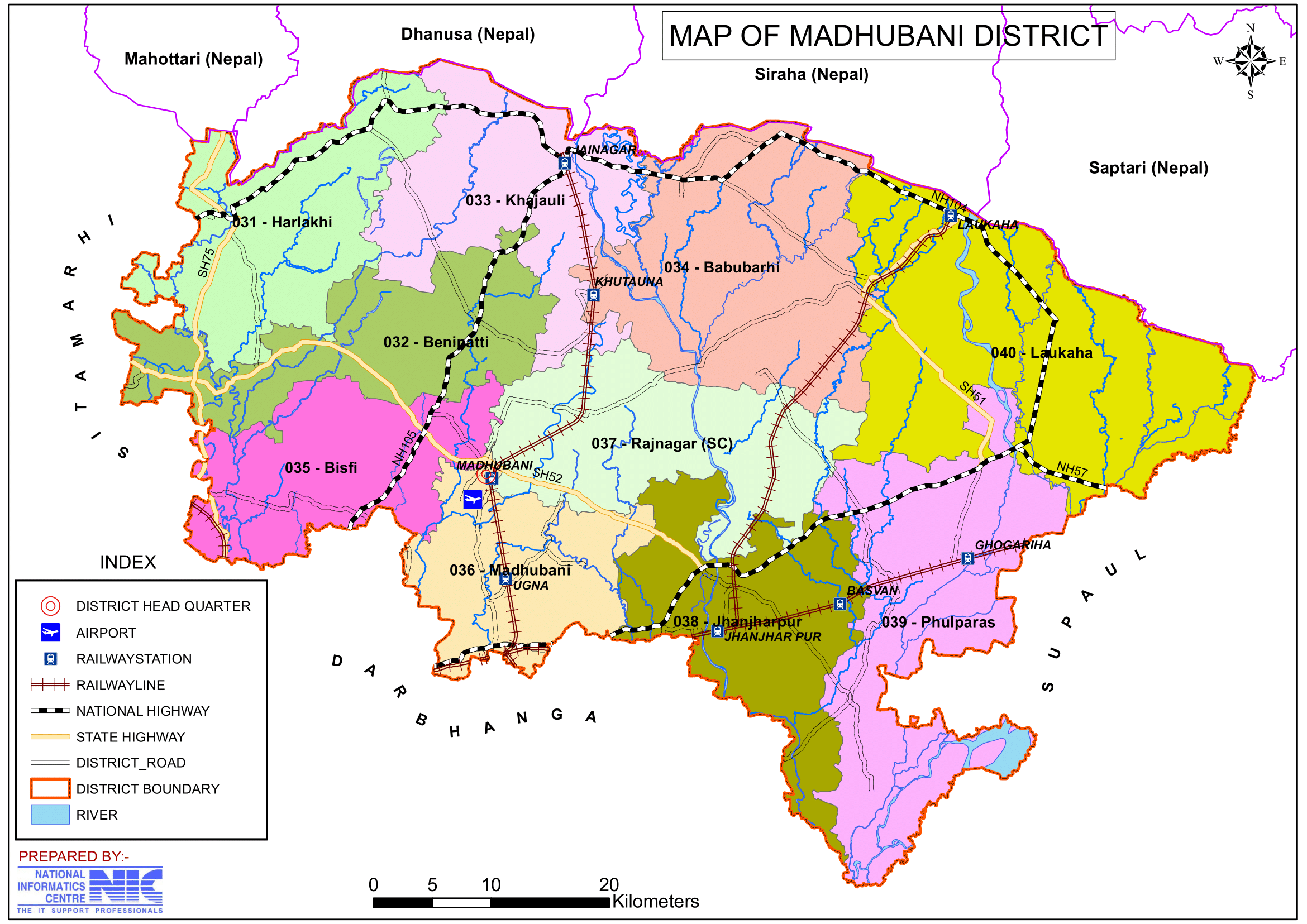
- No. of Subdivision: 5 (Madhubani Sadar, Benipatti, Jhanjarpur, Phulparas, Jainagar)
- No. of Blocks: 21
- Madhubani Sadar- Madhubani, Pandaul, Rajnagar, Kaluahi, Rahika
- Benipatti- Benipatti, Bisfi, Harlakhi, Madhwapur, Basopatti, Ladania
- Jhanjarpur- Jhanjarpur, Andhratharhi, Lakhnaur, Madhepur, Ghoghardiha
- Phulparas- Phulparas, Laukahi, Khutauna
- Jainagar- Jainagar, Khajauli, Babubarhi
- Police Station: 26
- Incharge of Thana, Nagar,OP Incharge- Patauna, Ounsi (SHO- Rahika, Pandaul, Sakri, Khajauli, Kaluahi, Rajnagar, Babubarhi, Jainagar, Ladania, Basopatti, Benipatti, Arer, Bisfi, Khirhar, Madhwapur, Saharghat, Harlakhi, Jhanjarpur, Bhiravsthan, Madhepur, Bheja, Lakhnaur, Andhrathadi)
- Municipal Corporation (Nagar Nigam): 1 (Madhubani)
- Municipal Council (Nagar Parishad): 1 (Jhanjarpur)
- Nagar Panchayat: 4 (Ghoghardiha, Jainagar, Benipatti, Phulparas)
- Lok Sabha constituency: 2 (Madhubani, Jhanjharpur)
- Vidhan Sabha constituencies: 10
- 31- Harlakhi, 32- Benipatti, 33- Khajauli, 34- Babubarhi, 35- Bisfi, 36- Madhubani, 37- Rajnagar, 38- Jhanjharpur, 39- Phulparas, 40- Laukaha
- Key Features:
- Globally recognized for Madhubani (Mithila) paintings, a traditional art form.
- Known for cultural festivities and historical landmarks such as Kapileshwar Sthan and Uchaith Bhagwati Temple.
- Also a predominantly agrarian district producing paddy, wheat, and vegetables.
- Significance: Also a global ambassador for Mithila art and culture.
- Time zone: UTC+05:30 (IST)
- Major highways: NH-27, NH-227, NH-227J, NH-227L, NH-527A, NH-527B
- Official Website: madhubani.nic.in
Geography
- Location: Madhubani district is situated in the northern part of Bihar, furthermore, it shares its northern border with Nepal. Additionally, it is bounded by Darbhanga to the south, Sitamarhi to the west, Supaul to the east, and Madhesh Province of Nepal to the north.
- Area: The district covers an area of approximately 3,501 square kilometers.
- Rivers: Major rivers include the Kamla, Koshi, and Bhutahi Balan, which play a significant role in agriculture but also cause seasonal floods.
- Climate: The district experiences a humid subtropical climate with hot summers, heavy monsoons, as well as mild winters.
History
- Ancient Era: Madhubani is deeply rooted in the history of Mithila, which, particularly, finds mention in the Ramayana and other ancient texts. Moreover, the area was part of the Videha kingdom, ruled by King Janaka, the father of Sita.
- Medieval Period: The region saw the growth of Maithili culture under various dynasties, specifically, these included the Karnatas and the Oiniwar rulers.
- Modern History: Madhubani district was carved out of Darbhanga in 1972 and has since grown as a hub of Mithila culture, art, and tradition.
Demographics
- Population: As per the 2011 Census, Madhubani district has a population of approximately 4.48 million, thus, it is making it one of the most populous districts in Bihar and ranking 37th in India out of 640 districts.
- Literacy Rate: The district’s literacy rate is around 58.62%, with efforts ongoing to improve educational access.
- Population density: 1,282 inhabitants per square kilometre (3,320/sq mi).
- Population growth rate (2001–2011): 25.51%.
- Sex ratio: 926 females per 1,000 males.
- Urban population: Only 3.60% of the total population.
- Languages: Maithili is the predominant language, alongside Hindi and Urdu.
- Maithili: Spoken by 84.07% of the population.
- Urdu: Spoken by 12.86%
- Hindi: Spoken by 2.92%
- Other languages: Spoken by 0.15%
- Religious Composition (2011 Census):
- Hinduism: 81.39% of the population.
- Scheduled Castes: 13.08% of the population.
- Scheduled Tribes: 0.09% of the population.
- Islam: 18.25% of the population.
- Other/Not Stated: 0.10% of the population.
- Hinduism: 81.39% of the population.
Administration
- Headquarters: Madhubani town serves as the administrative headquarters.
- Subdivisions:
- The district is divided into five subdivisions: Madhubani, Jhanjharpur, Benipatti, Jainagar, and Phulparas.
- A subdivisional magistrate, therefore, leads each subdivision and is in charge of development, revenue-related tasks, and maintaining law and order.
- Blocks and circles:
- The district is divided into 21 Blocks and Circles.
- Madhubani Sadar- Madhubani, Pandaul, Rajnagar, Kaluahi, Rahika
- Benipatti- Benipatti, Bisfi, Harlakhi, Madhwapur, Basopatti, Ladania
- Jhanjarpur- Jhanjarpur, Andhratharhi, Lakhnaur, Madhepur, Ghoghardiha
- Phulparas- Phulparas, Laukahi, Khutauna
- Jainagar- Jainagar, Khajauli, Babubarhi
- A circle officer (CO) leads each circle, while a block development officer (BDO) leads each block.
- The district is divided into 21 Blocks and Circles.
- Governance: Madhubani district is part of the Tirhut division and is represented in both the Bihar Legislative Assembly and Parliament.
Economy
- Agriculture: The economy is primarily agrarian, indeed, rice, wheat, maize, pulses, and sugarcane being the major crops. Furthermore, the fertile alluvial soil supports high agricultural productivity.
- Art and Craft: The district is globally renowned for Madhubani–paintings, a traditional form of Mithila art practiced predominantly by women. Consequently, these paintings have gained recognition as a symbol of India’s cultural heritage.
- Handicrafts: Apart from paintings, Madhubani is also known for its pottery, textile works, and bamboo crafts.
- Industries: Small-scale industries related to agriculture, textiles, and specifically art dominate the economy.
- Madhubani was identified as one of India’s 250 most backward districts (out of 640) in 2006 by the Ministry of Panchayati Raj.
- The district receives funding under the Backward Regions Grant Fund (BRGF), along with 37 other districts in Bihar.
- Significant progress has been made in recent years, leading to notable developmental changes.
- Urbanization is expected to transform Madhubani, driving further growth and modernization.
Education
- In the mediaeval periods, Sanskrit literature and Indian philosophy, particularly Nyaya Shastra and Vaisheshika Sutra, were studied in this territory. Some of the academies founded by well-known intellectuals and philosophers, such Kalidas Dih, Vachaspati Mishra Dih, Ayachi Mishra Dih, Kumarila Bhatta Dih, Bisfi Vidyapati Dih, and Musaharniya Dih, are still standing.
- Madhubani has a growing educational infrastructure, with schools as well as colleges catering to the local population. Notable institutions include:
- Madhubani College
- R.K. College, Madhubani
- J.N. College, Nehra
Efforts are being made to enhance educational opportunities, particularly for women and underprivileged communities.
Culture
- Art and Literature: Madhubani paintings, characterized by their intricate patterns and vibrant colors, are, therefore, a UNESCO-recognized cultural heritage. The district has also contributed significantly to Maithili literature and poetry.
- Festivals: Festivals such as Chhath Puja, Durga Puja, and Sama Chakeva are celebrated with great enthusiasm. Moreover, Jhijhiya and Nachari are traditional dance forms that reflect the region’s cultural richness.
- Cuisine: The district is known for its Maithili cuisine, including dishes like litti chokha, ghughni, dal-pitha, and, in addition, sweets like balushahi and makhana-based delicacies.
Tourism
Madhubani attracts visitors for its cultural and historical significance. Key attractions include:
- Many locations in Madhubani are of religious, historical, and archeological significance to tourists, for instance, Andhratharhi, Balirajpur, Mangrauni, Ucchaith, Bhawanipur, Saurath, Satghara, Bisfi, and others.
- Uchhaith Bhagwati Temple: A revered religious site, specifically dedicated to Goddess Durga on the western bank of river Thumne. According to a legend, in fact, the renowned Sanskrit poet and dramatist Kalidas was blessed by Bhagwati at this place.
- Kapileshwar Temple: A famous temple dedicated to Lord Shiva.
- Saurath Sabha Gachhi: A historic site where traditional Maithili Brahmin marriage alliances were fixed. Numerous Panjikars who maintain the various families’ genealogical records live both inside and outside of this area.
- Madhubani Painting Villages: Villages like Jitwarpur and Ranti are, indeed, hubs for Madhubani art, attracting art lovers and tourists from around the world.
- In the past, the Madhubani district was home to a number of Ashramas dedicated to notable Vedic sages, consequently, these places became significant centers of learning and spritual growth. Among these such as, the Shringi Rishi Ashram in Singiya, the Vishwamitra Ashram in Bisaul, the Kapil Ashram in Kapileshwar Sthan, and the Yajnavalkya Ashram in Jagban.
- In a similar vein, therefore, the area contains a number of sites connected to the Ramayana or the Mahabharata.
- The first known meeting between Lord Rama and Goddess Sita is said to have taken place initially at Girija Devi Mandir in Phulhar.
- It is thought that during the ‘Pandavas‘ exile, Arjuna in the Mahabharata concealed his renowned Gandiva bow near Gandiveshwar Sthan.
- It is also said that Arjuna built a Shivalinga called Baneshwar Nath Mahadev at Baneshwar Sthan in Barri village.
- The Ramayana is also connected to Kalna’s Kalyaneshwar Mahadev Mandir. Specifically, the Shivalinga of the temple is said to have been created in Mithila by King Janaka.
Transportation
- Railways: Madhubani has good railway connectivity with cities, such as Patna, Delhi, and Kolkata. Additionally, Jainagar is a prominent railway station connecting the district to Nepal.
- Roadways: The district is well-connected by National and State Highways, furthermore, it has regular bus services to neighboring towns and cities.
- Nearest Airport: The nearest airport is Darbhanga Airport, located about 25 km from Madhubani, providing domestic flight services.
- Laukaha town in the district of Madhubani, Bihar, is close to the border of Nepalese town of Thadi. Furthermore, one of the mutual trade routes between India and Nepal includes the towns of Thadi in Nepal and Laukaha in India. In addition, the government of India has set up a Land Customs Station with a Superintendent level officer for Import and Export between India and Nepal.
Challenges
- Floods: Seasonal floods caused by rivers such as Kamla and Kosi disrupt life and agriculture annually.
- Infrastructure: Despite progress, the district faces challenges in road development, healthcare, and educational infrastructure.
- Employment: A lack of large-scale industries forces many residents to migrate to other parts of India for work.
Conclusion
Madhubani district is rich in culture, history, and specifically art. Its Madhubani paintings have brought international recognition, while its traditions and festivals reflect the vibrant Mithila culture. Despite challenges, the district continues to preserve its heritage and grow as a center for art, education, and tourism in Bihar.
Would you like more details about any specific Topics on Bihar? Comment Below or Checkout these topics 😊
मधुबनी जिला: मैथिली कला और परंपरा की विशेष भूमि
अवलोकन
मधुबनी, भारत के बिहार राज्य के मिथिला क्षेत्र का एक जिला है, जो अपनी सांस्कृतिक विरासत, विशेष रूप से विश्व प्रसिद्ध मधुबनी पेंटिंग के लिए प्रसिद्ध है। यह जिला मिथिला के इतिहास और परंपरा का एक महत्वपूर्ण हिस्सा है, जो इसकी अनूठी कला, भाषा और रीति-रिवाजों को संरक्षित करता है।
मधुबनी का गठन बिहार के जिला पुनर्गठन के एक भाग के रूप में 1972 में पिछले दरभंगा जिले से किया गया था। यह कभी दरभंगा जिले का उत्तरी भाग था। इसमें 21 विकास खंड शामिल हैं। मधुबनी, उत्तर में नेपाल के पहाड़ी क्षेत्र से घिरा हुआ है और दक्षिण में अपने मूल जिले दरभंगा, पश्चिम में सीतामढ़ी और पूर्व में सुपौल की सीमा तक फैला हुआ है, जो कभी मिथिला के नाम से जाने जाने वाले क्षेत्र का केंद्र है, और इस जिले ने अपनी एक अलग पहचान बनाए रखी है।
हालाँकि जिले के कई क्षेत्रों में सबसे पुराने आदिवासी निवासियों के अवशेष पाए जा सकते हैं, लेकिन इस क्षेत्र में अनिवार्य रूप से कोई प्रागैतिहासिक स्थल नहीं हैं। हंटर ने अपने “सांख्यिकीय खातों” में थारू लोगों को शामिल किया, जो पूर्व मधुबनी उपखंड में रहने वाले लोगों का एक समूह था। हालाँकि भरों के बारे में कोई ठोस जानकारी नहीं है, लेकिन उन्हें भी इसी तरह एक स्वदेशी जाति का सदस्य माना जाता है। जिले के उत्तर-पूर्व में बिहारी समुदायों की मौजूदगी से पता चलता है कि उनका इस अलग-थलग इलाके पर कुछ प्रभाव रहा होगा।
डॉ. सुनीति कुमार चटर्जी की “किरात जनककीर्ति” के अनुसार, किरात भी लंबे समय तक इस क्षेत्र में रहते थे। महाभारत में किरात संस्कृति का भी उल्लेख मिलता है। ऐसा लगता है कि इस क्षेत्र के आर्यनीकरण से पहले इस क्षेत्र में स्वदेशी लोग रहते थे, उस समय शिव पूजा आम थी। भले ही जनक परिवार आर्य सभ्यता में सबसे आगे था, लेकिन उन्हें शैव-प्रधान स्थानीय धर्म के लिए रियायतें देनी पड़ीं, जैसा कि भगवान शिव की पूजा के साथ उनके संबंधों से पता चलता है। यह क्षेत्र विदेह राज्य का एक बड़ा हिस्सा था। समय के साथ, जनक के नाम से जाने जाने वाले शासकों के उत्तराधिकार ने इस पर शासन किया।
लोककथाओं के अनुसार, पंडौल (ब्लॉक मुख्यालय) पांडवों से जुड़ा हुआ है, जो अपने निर्वासन के दौरान वर्तमान जिले के कुछ हिस्सों में रहते थे। परंपरा के अनुसार, बेनीपट्टी थाने के उत्तर-पूर्व कोने में फुलहर गांव एक फूल उद्यान है, जहां राजाओं के पुजारी पूजा के लिए फूल इकट्ठा करते थे। इसका मंदिर देवी गिरिजा के मंदिर से पहचाना जाता है, जिसकी पूजा सीता ने राम से विवाह से पहले की थी। विदेह की राजधानी जनकपुर नेपाल में जिले के उत्तर-पश्चिम में थोड़ी दूरी पर स्थित है। किंवदंती और परंपरा के अनुसार, यह इलाका कई पुराने ऋषियों और महापुरुषों का घर है। कपिल का संबंध ककरौल गांव से है, गौतम की पत्नी अहिल्या का संबंध अहियारी से, विश्वामित्र का संबंध बिसौल से और याज्ञवल्क्य (मिथिला के प्रसिद्ध ऋषि से संबंधित) का संबंध जगबान से है।
मगध साम्राज्य के संस्थापक बिम्बिसार की शाही शासक बनने की आकांक्षा थी और उनके बेटे अजात शत्रु भी अपवाद नहीं थे। अजात शत्रु ने पूरे उत्तर बिहार पर विजय प्राप्त की और लिच्छवियों को हराया। उन्होंने मिथिला पर मगध साम्राज्य का शासन स्थापित किया। लिच्छवियों का इतिहास गुप्त काल तक निर्बाध रूप से जारी रहा। लिच्छवियों ने नेपाल में राजतंत्र की स्थापना की, और वैशाली के लिच्छवियों ने तिब्बत के पहले शाही परिवार के पूर्वज थे। नेपाल और तिब्बत में लिच्छवियों का प्रवास उत्तर बिहार के इतिहास में एक महत्वपूर्ण घटना है, और चूंकि नेपाल का रास्ता मधुबनी जिले से होकर गुजरता था, जो इस क्षेत्र का केंद्र है, इसलिए इस महाकाव्य यात्रा में इसकी प्रमुख भूमिका रही होगी।
मधुबनी उस धार्मिक और सांस्कृतिक उथल-पुथल का हिस्सा रहा होगा जिसने छठी शताब्दी ईसा पूर्व में गंगा घाटी के निवासियों को इतना गहराई से प्रभावित किया था। दो महान सुधारकों, महावीर और बुद्ध की शिक्षाओं का पूरे उत्तर बिहार पर गहरा प्रभाव पड़ा, इसलिए यह तर्क दिया जा सकता है कि मधुबनी के लोगों ने दोनों सुधार आंदोलनों के प्रसार में सक्रिय रूप से योगदान दिया। यह सुझाव दिया गया है कि महावीर वैशाली के पड़ोस में रहने वाले एक वैदेह थे और मिथिला की बेटी के पुत्र थे। बुद्ध को भी वैशाली बहुत पसंद था और उन्होंने मिथिला की तीन यात्राएँ कीं। मधुबनी जिले और उसके आस-पास के इलाकों का उल्लेख बौद्ध और जैन साहित्य में कई बार मिलता है। कुषाण काल और गुप्त काल के बीच मधुबनी के इतिहास के बारे में बहुत कम जानकारी है।
थोड़े समय की अशांति के बाद, ओइनवारों ने – जिन्हें कामेश्वर ठाकुर या सुगौना राजवंश भी कहा जाता है – मधुबनी पर कब्ज़ा कर लिया। पूरे मिथिला ने इन हिंदू सरदारों को नाराज़ नहीं किया। बंगाली हाजीरिया द्वारा तिरहुत को दो भागों में विभाजित करने के बाद ओइनवार राजा ने अपनी राजधानी सुगौना में स्थानांतरित कर दी, जो मधुबनी के करीब है। उसके बाद, यह क्षेत्र मुगल सूबा का हिस्सा बना रहा। अगली डेढ़ सदी में, कुछ भी उल्लेखनीय नहीं हुआ।
1764 में बक्सर की लड़ाई में अपनी शानदार जीत के बाद अंग्रेजों ने बंगाल के निचले प्रांतों पर निर्विवाद नियंत्रण प्राप्त कर लिया। इसलिए मधुबनी और बिहार के अन्य हिस्सों को ब्रिटिश शासन के अधीन लाया गया। ब्रिटिश प्रशासन द्वारा कानून और व्यवस्था स्थापित की गई। उन्हें मिथिला में उपद्रवियों के अलावा नेपाली घुसपैठियों से भी जूझना पड़ा। भारत-नेपाल युद्ध नेपाल के साथ संघर्ष का परिणाम था। नेपाल के साथ शांति समझौते के बाद 1857 के आंदोलन तक ब्रिटिश अधिकारियों ने अपेक्षाकृत शांत अवधि का आनंद लिया।
बिहार के कई अन्य जिलों की तरह, मधुबनी जिला 1857 में देशभक्ति के जोश से भरा हुआ था। बाद में, मधुबनी जिले ने असहयोग आंदोलन की अपील का पर्याप्त रूप से जवाब दिया, और कई लोगों ने महात्मा गांधी के कारण का समर्थन करने के लिए अपनी सेवाएं दीं। कांग्रेस के कर्मचारियों के लिए खादी की बुनाई और कताई अनिवार्य कर दी गई। मधुबनी में, एक खादी केंद्र स्थापित किया गया था। इसके संचालन को उत्तरोत्तर बढ़ाया गया। खादी ने जल्दी ही लोकप्रियता हासिल कर ली, और मधुबनी खादी निर्माण के एक प्रमुख केंद्र के रूप में जाना जाने लगा। खादी बुनाई और कताई की लोकप्रियता से जिले के लोग राष्ट्रवादी आंदोलन का समर्थन करने के लिए बहुत प्रेरित हुए। मधुबनी जिला देश की आजादी की लड़ाई में महत्वपूर्ण था।
मधुबनी जिले के बारे में मुख्य तथ्य
- देश: भारत
- राज्य: बिहार
- क्षेत्र: मिथिला
- प्रमंडल: दरभंगा
- स्थापना: 1972
- निर्देशांक: 26°24′N 86°15′E
- क्षेत्रफल: 3,501 km2 (1,352 वर्ग मील)
- जिला मुख्यालय: मधुबनी
- जिला मजिस्ट्रेट (DM): अरविंद कुमार वर्मा, IAS
- पुलिस अधीक्षक (SP): योगेन्द्र कुमार, IPS
- जनसंख्या (2011):
- कुल: 4,487,379
- घनत्व: 1,300/km2 (3,300/वर्ग मील)
- साक्षरता दर: 60.9%
- लिंगानुपात: 925
- राजभाषा: हिंदी
- मातृभाषा: मैथिली
- ग्राम पंचायतें: 399
- गांव: 1115 (लगभग)
- अनुमण्डल की संख्या: 5 (मधुबनी सदर, बेनीपट्टी, झंझारपुर, फुलपरास, जयनगर)
- ब्लॉकों की संख्या: 21
- मधुबनी सदर-मधुबनी, पंडौल, राजनगर, कलुआही, रहिका
- बेनीपट्टी- बेनीपट्टी, बिस्फी, हरलाखी, मधवापुर, बासोपट्टी, लदनियां
- झंझारपुर- झंझारपुर, अंधराठाढ़ी, लखनौर, मधेपुर, घोघरडीहा
- फुलपरास- फुलपरास, लौकही, खुटौना
- जयनगर- जयनगर, खजौली, बाबूबरही
- पुलिस स्टेशन: 26
- थाना प्रभारी, नगर, ओपी प्रभारी- पतौना, औंसी (थाना प्रभारी- रहिका, पंडौल, सकरी, खजौली, कलुआही, राजनगर, बाबूबरही, जयनगर, लदनियां, बासोपट्टी, बेनीपट्टी, अरेर, बिस्फी, खिरहर, मधवापुर, साहरघाट, हरलाखी, झंझारपुर , भिरावस्थान, मधेपुर, भेजा, लखनौर, अंधराठाढ़ी)
- नगर निगम: 1 (मधुबनी)
- नगर परिषद: 1 (झंझारपुर)
- लोकसभा क्षेत्र: 2 (मधुबनी, झंझारपुर)
- नगर पंचायत: 4 (घोघरडीहा, जयनगर, बेनीपट्टी, फुलपरास)
- विधान सभा क्षेत्र: 10
- 31- हरलाखी, 32- बेनीपट्टी, 33- खजौली, 34- बाबूबरही, 35- बिस्फी, 36- मधुबनी, 37- राजनगर, 38- झंझारपुर, 39- फुलपरास, 40- लौकहा
- प्रमुख विशेषताऐं:
- पारंपरिक कला रूप, मधुबनी (मिथिला) पेंटिंग के लिए विश्व स्तर पर मान्यता प्राप्त है।
- सांस्कृतिक उत्सवों और कपिलेश्वर स्थान और उच्चैठ भगवती मंदिर जैसे ऐतिहासिक स्थलों के लिए जाना जाता है।
- धान, गेहूं और सब्जियों का उत्पादन करने वाला मुख्य रूप से कृषि प्रधान जिला।
- महत्व: मिथिला कला और संस्कृति के लिए एक वैश्विक राजदूत।
- समय क्षेत्र: UTC+05:30 (IST)
- प्रमुख राजमार्ग: NH-27, NH-227, NH-227J, NH-227L, NH-527A, N- 527B
- आधिकारिक वेबसाइट: madhubani.nic.in
भूगोल
- स्थान: मधुबनी बिहार के उत्तरी भाग में स्थित है, जिसकी उत्तरी सीमा नेपाल से लगती है। यह दक्षिण में दरभंगा, पश्चिम में सीतामढ़ी, पूर्व में सुपौल और उत्तर में नेपाल के मधेश प्रांत से घिरा है।
- क्षेत्र: जिले का क्षेत्रफल लगभग 3,501 वर्ग किलोमीटर है।
- नदियाँ: प्रमुख नदियों में कमला, कोशी और भुतही बालन शामिल हैं, जो कृषि में महत्वपूर्ण भूमिका निभाती हैं, लेकिन मौसमी बाढ़ का कारण भी बनती हैं।
- जलवायु: जिले में गर्म ग्रीष्मकाल, भारी मानसून और हल्की सर्दियाँ के साथ आर्द्र उपोष्णकटिबंधीय जलवायु होती है।
इतिहास
- प्राचीन युग: मधुबनी मिथिला के इतिहास में गहराई से निहित है, जिसका उल्लेख रामायण और अन्य प्राचीन ग्रंथों में मिलता है। यह क्षेत्र विदेह साम्राज्य का हिस्सा था, जिस पर सीता के पिता राजा जनक का शासन था।
- मध्यकालीन काल: इस क्षेत्र में कर्नाटक और ओइनिवार शासकों सहित विभिन्न राजवंशों के तहत मैथिली संस्कृति का विकास हुआ।
- आधुनिक इतिहास: इस जिले को 1972 में दरभंगा से अलग किया गया था और तब से यह मिथिला संस्कृति, कला और परंपरा के केंद्र के रूप में विकसित हुआ है।
जनसांख्यिकी
- जनसंख्या: 2011 की जनगणना के अनुसार, मधुबनी जिले की आबादी लगभग 4.48 मिलियन है, जो इसे बिहार के सबसे अधिक आबादी वाले जिलों में से एक बनाता है और भारत के 640 जिलों में से 37वें स्थान पर है।
- साक्षरता दर: जिले की साक्षरता दर लगभग 58.62% है, और शिक्षा तक पहुँच में सुधार के लिए प्रयास जारी हैं।
- जनसंख्या घनत्व: 1,282 निवासी प्रति वर्ग किलोमीटर (3,320/वर्ग मील)।
- जनसंख्या वृद्धि दर (2001-2011): 25.51%
- लिंग अनुपात: प्रति 1,000 पुरुषों पर 926 महिलाएँ।
- शहरी आबादी: कुल आबादी का केवल 3.60%
- भाषाएँ: हिंदी और उर्दू के साथ मैथिली प्रमुख भाषा है।
- मैथिली: 84.07% आबादी द्वारा बोली जाती है।
- उर्दू: 12.86% द्वारा बोली जाती है।
- हिंदी: 2.92% द्वारा बोली जाती है।
- अन्य भाषाएँ: 0.15% द्वारा बोली जाती हैं।
- धार्मिक संरचना (2011 की जनगणना):
- हिंदू धर्म: आबादी का 81.39%
- अनुसूचित जाति: आबादी का 13.08%
- अनुसूचित जनजाति: आबादी का 0.09%
- इस्लाम: आबादी का 18.25%
- अन्य/नहीं बताया गया: आबादी का 0.10%
- हिंदू धर्म: आबादी का 81.39%
प्रशासन
- मुख्यालय: मधुबनी शहर प्रशासनिक मुख्यालय के रूप में कार्य करता है।
- उपखंड:
- जिले को पांच उपमंडलों में विभाजित किया गया है: मधुबनी, झंझारपुर, बेनीपट्टी, जयनगर और फुलपरास।
- एक उपविभागीय मजिस्ट्रेट प्रत्येक उपविभाग का नेतृत्व करता है और विकास, राजस्व संबंधी कार्यों और कानून एवं व्यवस्था बनाए रखने का प्रभारी होता है।
- ब्लॉक और सर्कल:
- जिले को 21 ब्लॉक और सर्किल में बांटा गया है: रहिका, पंडौल, राजनगर, बाबूबरही, कलुआही, खजौली, जयनगर, लदनिया, बासोपट्टी, बेनीपट्टी, बिस्फी, हरलाखी, मधवापुर, झंझारपुर, अंधराठाढ़ी, लखनौर, मधेपुर, फुलपरास, घोघरडीहा, खुटौना और लौकही।
- मधुबनी सदर-मधुबनी, पंडौल, राजनगर, कलुआही, रहिका
- बेनीपट्टी- बेनीपट्टी, बिस्फी, हरलाखी, मधवापुर, बासोपट्टी, लदनियां
- झंझारपुर- झंझारपुर, अंधराठाढ़ी, लखनौर, मधेपुर, घोघरडीहा
- फुलपरास- फुलपरास, लौकही, खुटौना
- जयनगर- जयनगर, खजौली, बाबूबरही
- प्रत्येक सर्कल का नेतृत्व एक सर्कल अधिकारी (सीओ) करता है, जबकि प्रत्येक ब्लॉक का नेतृत्व एक खंड विकास अधिकारी (बीडीओ) करता है।
- जिले को 21 ब्लॉक और सर्किल में बांटा गया है: रहिका, पंडौल, राजनगर, बाबूबरही, कलुआही, खजौली, जयनगर, लदनिया, बासोपट्टी, बेनीपट्टी, बिस्फी, हरलाखी, मधवापुर, झंझारपुर, अंधराठाढ़ी, लखनौर, मधेपुर, फुलपरास, घोघरडीहा, खुटौना और लौकही।
- शासन: मधुबनी जिला तिरहुत प्रमंडल का हिस्सा है और बिहार विधानसभा और संसद दोनों में इसका प्रतिनिधित्व है।
- लोकसभा क्षेत्र: मधुबनी, झंझारपुर
- विधान सभा क्षेत्र: 10
- 31- हरलाखी, 32- बेनीपट्टी, 33- खजौली, 34- बाबूबरही, 35- बिस्फी, 36- मधुबनी, 37- राजनगर, 38- झंझारपुर, 39- फुलपरास, 40- लौकहा
अर्थव्यवस्था
- कृषि: अर्थव्यवस्था मुख्य रूप से कृषि आधारित है, जिसमें चावल, गेहूं, मक्का, दालें और गन्ना प्रमुख फसलें हैं। उपजाऊ जलोढ़ मिट्टी मिट्टी उच्च कृषि उत्पादकता का समर्थन करती है।
- कला और शिल्प: यह जिला मधुबनी पेंटिंग के लिए विश्व स्तर पर प्रसिद्ध है, जो मिथिला कला का एक पारंपरिक रूप है जिसे मुख्य रूप से महिलाएं करती हैं। इन पेंटिंग्स को भारत की सांस्कृतिक विरासत के प्रतीक के रूप में मान्यता मिली है।
- हस्तशिल्प: पेंटिंग के अलावा, मधुबनी मिट्टी के बर्तन, कपड़ा निर्माण और बांस शिल्प के लिए जाना जाता है।
- उद्योग: कृषि, कपड़ा और कला से संबंधित लघु उद्योग अर्थव्यवस्था पर हावी हैं।
- पंचायती राज मंत्रालय द्वारा 2006 में मधुबनी को भारत के 250 सबसे पिछड़े जिलों (640 में से) में से एक के रूप में पहचाना गया था।
- मधुबनी जिले को बिहार के 37 अन्य जिलों के साथ पिछड़ा क्षेत्र अनुदान निधि (बीआरजीएफ) के तहत धन प्राप्त होता है।
- हाल के वर्षों में उल्लेखनीय प्रगति हुई है, जिससे उल्लेखनीय विकासात्मक परिवर्तन हुए हैं।
- शहरीकरण से मधुबनी में बदलाव आने की उम्मीद है, जिससे विकास और आधुनिकीकरण को बढ़ावा मिलेगा।
शिक्षा
- मध्यकालीन काल में, संस्कृत साहित्य और भारतीय दर्शन, विशेष रूप से न्याय शास्त्र और वैशेषिक सूत्र का अध्ययन किया जाता था। इस क्षेत्र में प्रसिद्ध बुद्धिजीवियों और दार्शनिकों द्वारा स्थापित कुछ अकादमियाँ, जैसे कि कालिदास दीह, वाचस्पति मिश्र दीह, अयाची मिश्र दीह, कुमारिला भट्ट दीह, बिस्फी विद्यापति दीह और मुसहरनिया दीह, अभी भी मौजूद हैं।
- मधुबनी में शैक्षिक बुनियादी ढाँचा बढ़ रहा है , स्थानीय आबादी के लिए स्कूल और कॉलेज हैं। उल्लेखनीय संस्थानों में शामिल हैं:
- मधुबनी कॉलेज
- आर.के. कॉलेज, मधुबनी
- जे.एन. कॉलेज, नेहरा
विशेष रूप से महिलाओं और वंचित समुदायों के लिए शैक्षिक अवसरों को बढ़ाने के प्रयास किए जा रहे हैं।
पर्यटन
मधुबनी अपने सांस्कृतिक और ऐतिहासिक महत्व के कारण पर्यटकों को आकर्षित करता है। मुख्य आकर्षणों में शामिल हैं:
- मधुबनी में कई स्थान पर्यटकों के लिए धार्मिक, ऐतिहासिक और पुरातात्विक महत्व के हैं, जिनमें आंध्राथारही, बलिराजपुर, मंगरौनी, उच्चैठ, भवानीपुर, सौराठ, सतघरा, बिस्फी और अन्य शामिल हैं।
- उच्चैठ भगवती मंदिर: थुम्ने नदी के पश्चिमी तट पर देवी दुर्गा को समर्पित एक प्रतिष्ठित धार्मिक स्थल। एक किंवदंती के अनुसार, प्रसिद्ध संस्कृत कवि और नाटककार कालिदास को इस स्थान पर भगवती ने आशीर्वाद दिया था।
- कपिलेश्वर मंदिर: भगवान शिव को समर्पित एक प्रसिद्ध मंदिर।
- सौरठ सभा गाछी: एक ऐतिहासिक स्थल जहाँ पारंपरिक मैथिली ब्राह्मण विवाह संबंध तय किए गए थे। कई पंजीकर जो विभिन्न परिवारों के वंशावली रिकॉर्ड को बनाए रखते हैं, इस क्षेत्र के अंदर और बाहर दोनों जगह रहते हैं।
- मधुबनी पेंटिंग गाँव: जितवारपुर और रांटी जैसे गाँव मधुबनी कला के केंद्र हैं, जो दुनिया भर से कला प्रेमियों और पर्यटकों को आकर्षित करते हैं।
- अतीत में, मधुबनी जिला कई आश्रमों का घर था जो उल्लेखनीय वैदिक ऋषियों को समर्पित थे। इनमें से कुछ हैं, सिंगिया में श्रृंगी ऋषि आश्रम, बिसौल में विश्वामित्र आश्रम, कपिलेश्वर स्थान में कपिल आश्रम और जगबन में याज्ञवल्क्य आश्रम।
- इसी तरह, इस क्षेत्र में रामायण या महाभारत से जुड़े कई स्थल हैं।
- कहा जाता है कि भगवान राम और देवी सीता के बीच पहली ज्ञात मुलाकात फुलहर में गिरिजा देवी मंदिर में हुई थी।
- ऐसा माना जाता है कि ‘पांडवों’ के वनवास के दौरान, महाभारत में अर्जुन ने गांडीवेश्वर स्थान के पास अपना प्रसिद्ध गांडीव धनुष छिपाया था।
- ऐसा कहा जाता है कि अर्जुन ने बर्री गांव के बनेश्वर स्थान पर बनेश्वर नाथ महादेव नामक शिवलिंग का निर्माण किया था।
- रामायण का संबंध कलना के कल्याणेश्वर महादेव मंदिर से भी है। कहा जाता है कि मंदिर का शिवलिंग मिथिला में राजा जनक द्वारा बनाया गया था।
परिवहन
- रेलवे: मधुबनी का पटना, दिल्ली और कोलकाता जैसे शहरों से अच्छा रेल संपर्क है। जयनगर जिले को नेपाल से जोड़ने वाला एक प्रमुख रेलवे स्टेशन है।
- सड़क मार्ग: यह जिला राष्ट्रीय और राज्य राजमार्गों से अच्छी तरह जुड़ा हुआ है, तथा पड़ोसी शहरों और कस्बों के लिए नियमित बस सेवाएँ उपलब्ध हैं।
- निकटतम हवाई अड्डा: निकटतम हवाई अड्डा दरभंगा हवाई अड्डा है, जो मधुबनी से लगभग 25 किमी दूर स्थित है, जो घरेलू उड़ान सेवाएँ प्रदान करता है।
- बिहार के मधुबनी जिले में लौकाहा शहर नेपाली शहर ठाडी की सीमा के करीब है। भारत और नेपाल के बीच आपसी व्यापार मार्गों में से एक नेपाल में ठाडी और भारत में लौकाहा शहर शामिल हैं। भारत सरकार ने भारत और नेपाल के बीच आयात और निर्यात के लिए अधीक्षक स्तर के अधिकारी के साथ एक भूमि सीमा शुल्क स्टेशन स्थापित किया है।
चुनौतियाँ
- बाढ़: कमला और कोसी जैसी नदियों के कारण होने वाली मौसमी बाढ़ हर साल जीवन और कृषि को बाधित करती है।
- बुनियादी ढाँचा: प्रगति के बावजूद, जिले को सड़क विकास, स्वास्थ्य सेवा और शैक्षिक बुनियादी ढाँचे में चुनौतियों का सामना करना पड़ रहा है।
- रोजगार: बड़े पैमाने पर उद्योगों की कमी के कारण कई निवासियों को काम के लिए भारत के अन्य भागों में पलायन करना पड़ता है।
निष्कर्ष
मधुबनी संस्कृति, इतिहास और कला से समृद्ध जिला है। इसकी मधुबनी पेंटिंग ने अंतरराष्ट्रीय पहचान दिलाई है, जबकि इसकी परंपराएँ और त्यौहार जीवंत मिथिला संस्कृति को दर्शाते हैं। चुनौतियों के बावजूद, जिला अपनी विरासत को संरक्षित करना जारी रखता है और बिहार में कला, शिक्षा और पर्यटन के केंद्र के रूप में विकसित होता है।
क्या आप बिहार के किसी विशेष विषय के बारे में अधिक जानकारी चाहते हैं? नीचे टिप्पणी करें या इन विषयों का संदर्भ लें 😊
पदानुक्रमिक संरचना: बिहार का विस्तृत रोडमैप
बिहार में प्रमंडल और उसके जिलों का विवरण
Important Links
𝕋𝕙𝕒𝕟𝕜 𝕐𝕠𝕦 𝔽𝕠𝕣 𝕍𝕚𝕤𝕚𝕥𝕚𝕟𝕘 𝕆𝕦𝕣 𝕎𝕖𝕓𝕤𝕚𝕥𝕖𝕤 🙂
4 thoughts on “Madhubani District: Special Land of Maithili Art and Culture”