
Purnia District: An Overview
Purnia district, often referred to as the “Gateway of Northeast India”, is one of 38th Bihar’s oldest districts with a rich historical, cultural, and economic significance. Located in the northeastern part of Bihar, Purnia is known for its agricultural productivity, diverse culture, and strategic geographical location. The Purnia district has borders with Araria to the north, Kishanganj to the east, Katihar to the south, and Madhepura and Saharsa to the west. The district’s administrative center is located at Purnia town. It is one of the district under the Purnia division.
The district covers an area of 3,229 km2 (1,247 sq mi). Purnia established as a district on 14 February 1770. Since 1947, Purnia has maintained its custom of flying the national flag at 12:07 a.m. on Independence Day. Katihar in 1976, Araria, and Kishanganj in 1990 were the three districts that were separated from Purnia district.
Ancient Era
Since the late Vedic era (c. 1100–500 BCE), the District of Purnia has been a part of Mithilanchal (Mithila Region). Mithila initially gained to prominence when Indo-Aryans migrated there and founded the Mithila Kingdom, also known as the Kingdom of the Videhas. Videha, Kuru, and Pañcāla emerged as South Asia’s principal centers of culture and politics. The Videha Kingdom’s rulers were known as Janakas. The Videha Kingdom was eventually integrated into the Vajji confederacy, which had its capital in Vaishali, also located in Mithila.
The Anas and Pundras were the first people to live in Purnea. While the Pundras, despite having Aryan ancestry, were considered a lower class of people in the Aitarya Brahmana, Mahabharata, and Manu Samhita due to their disregard for performing sacred rites, the Anas are grouped with the Bengal tribes in the epics and were the easternmost tribes known to the Aryans during the Atharva Samhita period. The Mahabharata mythology states that Purnea is the location of Biratnagar, which provided refuge to the five Pandava brothers during their year-long secret exile.
Mughal Era
Purnea was a military border region ruled by a Faujdar during the Mughal era. The money received from this remote region was used to keep troops on duty to guard the boundaries against eastern and northern tribes. Purnea was a Sarkar in the Bengali Subah, according to Ain-i-Akbari. In 1757, Purnia’s local governor rebelled against Siraj ud-Daulah following the conquest of Calcutta. In 1765, Purnea was acquired by the East India Company, and on February 10, 1770, it was established as a district. Sarsi was a well-known indigo center under the Europeans, but Rambagh was a well-known European colony. Early in the 20th century, the Purnea district was a major site for the Swadeshi and Kissan Sabha movements.
The past of Purnea was splendid and full with history. Purain, which means Lotus, or the Goddess Puran Devi (Kali) are said to be the origins of the name Purnea. This temple is thought to have given Purnia its name. Five kilometers from the city center, the oldest temple dedicated to Mata Puran Devi is another point of interest in Purnia. Ramakrishna Mission, a distinctively constructed institution in Purnia, is well-known for hosting the October Durga Puja event. Other hypotheses also explain how Purnia got its name, namely that it was formerly known as Purna–Aranya, which translates to “complete jungle”.

Key Facts About Purnia District
- Country:
 India
India - State:
 Bihar
Bihar - Region: Mithila
- Division: Purnia
- Coordinates: 25.78°N 87.47°E
- Established: 14 February 1770
- Area: 3,229 km2 (1,247 sq mi)
- District Headquarters: Purnia
- District Magistrate (DM): Kundan Kumar, IAS
- Population (2011):
- Total: 3,264,619
- Density: 1,000/km2 (2,600/sq mi)
- Literacy Rate: 72.09%
- Sex Ratio: 921
- Official Language: Hindi
- Regional Language: Maithils
- Gram Panchayats: 246
- Villages: 1450 (approx)
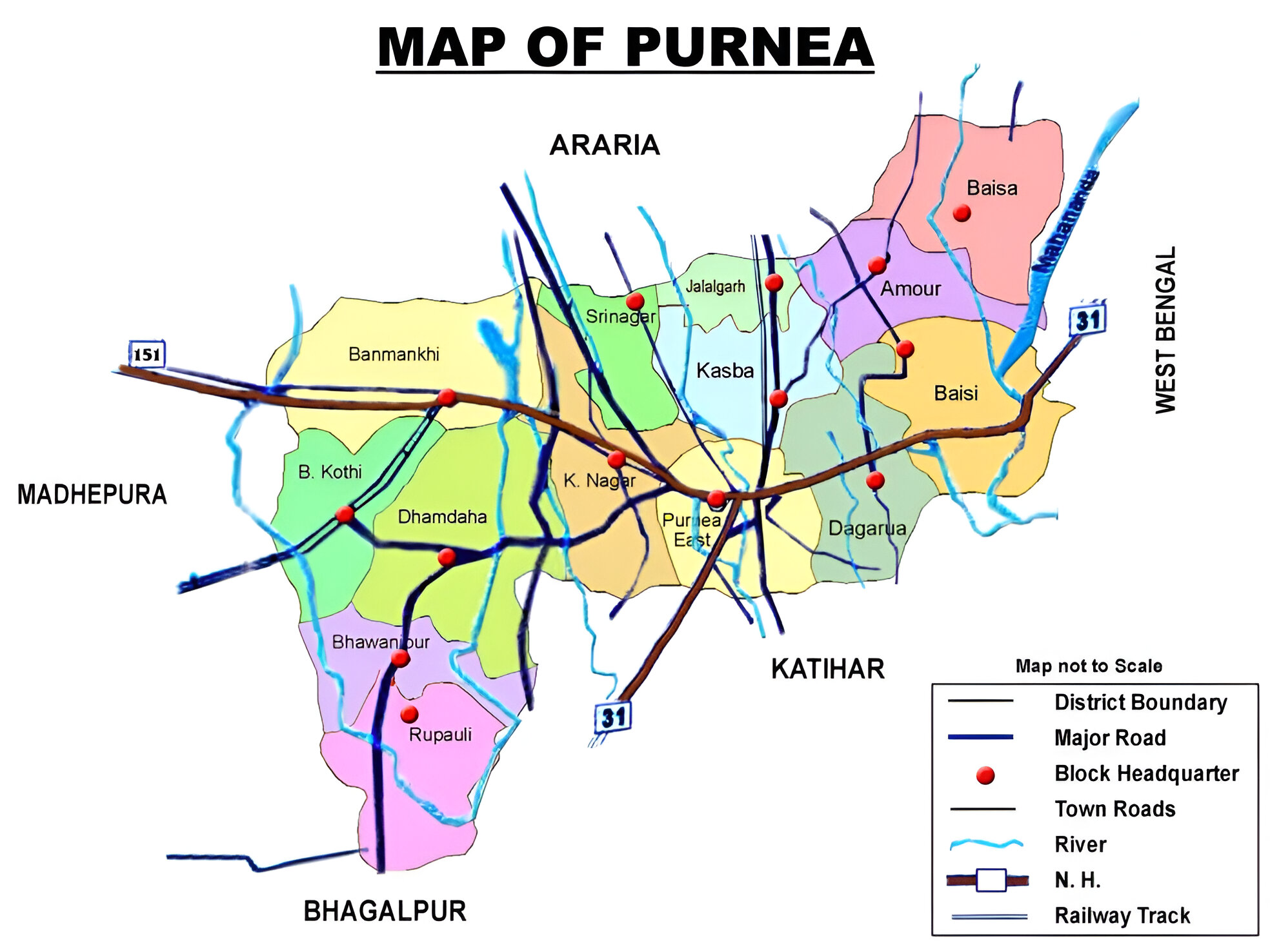
- No. of Subdivision: 4 (Purnea Sadar, Dhamdaha, Baisi, Banmankhi)
- No. of Blocks: 14
- Purnea Sadar- Purnea East, Jalalgarh, Kasba, Krityanand Nagar, Srinagar
- Dhamdaha- Dhamdaha, Rupauli, Bhawanipur, Barhara
- Baisi- Amaur, Baisa, Baisi, Dagarua
- Banmankhi- Banmankhi
- Police Station: 25
- (SP Purnea, DSP HQ, SDPO Purnea, SDPO Baunsi, SDPO Dhamdaha, SDPO Banmankhi) (PS- Bhawanipur, Kasba, Khajanchi Hat, Sadar, Angarh, Sarsi, Jankinagar, Tikamahi, Mirganj, Jalalgarh, Barhara Kothi, Banmankhi, Rupauli, Dhamdaha, Dhabaisi, Rauta, Amaur, Krityanand Nagar, Dagarua)
- Municipal Corporation (Nagar Nigam): 1 (Purnia)
- Nagar Panchayat: 2 (Banmankhi, Kasba Nagar)
- Rivers: Kosi, Mahane
- Lok Sabha constituency: 1 (Purnia)
- Vidhan Sabha constituencies: 7
- 56- Amour, 57- Baisi, 58- Kasba, 59- Banmankhi, 60- Rupauli, 61- Dhamdaha, 62- Purnia
- Key Features:
- Known as the “Gateway of Northeast India”, due to its strategic location connecting Bihar with the northeastern states.
- Rich agricultural land producing jute, maize, and paddy.
- Culturally vibrant, with a blend of folk traditions and modern influences.
- Significance: An important trade and agricultural hub in the region.
- Major Highways: NH-27, NH-31, NH-231, NH-131A
- Major Railway Lines:
- Barauni-Katihar, Saharsa and Purnia sections
- Barauni-Guwahati line
- Freedom Fighters: Shri Jibatsh Sharma ‘Himanshu’, Fuleshwar Prasad Yadav
- Postal Address: Head Post office, Near Girja Choke, Purnea- 854301, Phone: 18002666868
- Time Zone: UTC+05:30 (IST)
- Vehicle Registration: BR-11
- STD Code: 06454
- PIN Code: 854301
- Official Website: purnea.nic.in
Geography
- Location: Purnia lies in the northeastern part of Bihar, bordered by Araria to the north, Kishanganj to the east, Katihar to the south, and Madhepura and Saharsa to the west.
- Area: The district spans an area of approximately 3,229 square kilometers.
- Rivers:
- The area is low and mostly composed of rich, loamy alluvial soil. Major rivers that originate in the Himalayas run through the district include the Kosi, Mahananda, Ganga, Suwara Kali, Kari Kosi, Saura, Panar and Koli, offering significant benefits in terms of irrigation and water transportation but also pose a flood threat.
- Sand that has been deposited by variations in the Kosi’s course covers a large portion of the soil in the west. The three main crops it produces are bananas, maize, and jute.
- Climate: Purnia has a humid subtropical climate with hot summers, heavy monsoon rains, and cool winters.
History
- Ancient Era: The district has historical roots dating back to the Mauryan and Gupta periods. It is believed to have been part of the Mithila and Anga regions in ancient India.
- Colonial Period: During British rule, Purnia gained importance as an administrative unit. It served as the headquarters for the entire northeastern Bihar region.
- Formation: Purnia is one of the oldest districts of Bihar, established in 1770, and has played a vital role in the state’s administrative and economic development.
Demographics (According to the 2011 Census)
- Population:
- Total: Purnia district has a population of 3,264,619 (approximately 3.26 million), comparable to the population of Mauritania (a sovereign country in Northwest Africa).
- Ranking: 105th in India (out of 640 districts).
- Population Density: 1014 inhabitants per square kilometre (2,380/sq mi).
- Growth Rate (2001–2011): 28.66%, reflecting significant population increase.
- Literacy Rate: The literacy rate is 72.09%, with significant disparities between urban and rural areas.
- Sex Ratio: 930 females for every 1000 males, indicating a gender disparity.
- Urban Population: 10.51% of the total population.
- Religious Composition (2011 Census):
- Hinduism: 60.94%
- Scheduled Castes: 11.98%
- Scheduled Tribes: 4.27%
- Islam: 38.46%
- Other or not stated: 0.60%
- Hinduism: 60.94%
- Languages: The primary languages spoken are Maithili, Hindi, Urdu, Surjapuri, Bengali, Angika, and Santali, reflecting the region’s linguistic diversity.
- Hindi: 33.68%
- Urdu: 18.62%
- Others (under Hindi): 18.53%
- Maithili: 10.72%
- Surjapuri: 8.73%
- Bengali: 4.51%
- Santali: 2.50%
- Others: 2.71%
Administration
- Headquarters: Purnia town serves as the district headquarters.
- Subdivisions:
- The district is divided into four subdivisions: Purnia Sadar, Dhamdaha, Banmankhi, and Baisi, which are further subdivided into blocks.
- Each subdivision is led by a subdivisional magistrate who is in charge of development, revenue-related tasks, and maintaining law and order.
- Blocks and Circles:
- Purnia district is divided into 11 Blocks and Circles.
- Purnea Sadar- Purnea East, Jalalgarh, Kasba, Krityanand Nagar, Srinagar
- Dhamdaha- Dhamdaha, Rupauli, Bhawanipur, Barhara
- Baisi- Amaur, Baisa, Baisi, Dagarua
- Banmankhi- Banmankhi
- A circle officer (CO) leads each circle, while a Block Development Officer (BDO) leads each block.
- Purnia district is divided into 11 Blocks and Circles.
- Governance: Purnia falls under the Purnia division and is represented in both the Bihar Legislative Assembly and the Indian Parliament.
- Lok Sabha constituency: Purnia
- Vidhan Sabha constituencies: 7
- 56- Amour, 57- Baisi, 58- Kasba, 59- Banmankhi, 60- Rupauli, 61- Dhamdaha, 62- Purnia
Organisation Chart

Economy
- Agriculture: The district’s economy is predominantly agrarian. Major crops include rice, wheat, maize, jute, sugarcane, and pulses. The fertile soil and ample water resources make it a key agricultural hub in Bihar.
- Jute Industry: Purnia is known for its jute production and is sometimes referred to as the “Jute Capital of Bihar.”
- Trade and Commerce: The district is a regional trading center for agricultural produce and consumer goods. The proximity to West Bengal and Nepal enhances its commercial importance.
- Emerging Industries: Small-scale industries related to agro-products and jute are growing, although large-scale industrialization is still limited.
- Oil and Natural Gas Corporation has began searching for natural gas and crude oil deposits in the Purnia basin. The basin’s reserves are estimated to be over 465 million tonnes.
Education
Purnia has a mix of government and private educational institutions that cater to the district’s urban and rural populations:
- Purnea University: A prominent higher education institution offering undergraduate and postgraduate programs.
- Educational Institutions:
- Purnea College Purnea
- Government Polytechnic College, Purnea
- Purnea Engineering College, Purnea
- Purnea Mahila College
- Technical and Vocational Training: Institutions like the Government Polytechnic, Purnia, provide technical education and skill development.
- Schools: The district has several CBSE and BSEB-affiliated schools, striving to improve literacy and educational outcomes.
Culture
- Festivals: Purnia celebrates festivals like Chhath Puja, Durga Puja, Diwali, and Eid with enthusiasm, reflecting the diverse religious and cultural makeup of the region.
- Cuisine: The district’s cuisine is rooted in Maithili and Bengali traditions, with popular dishes like litti chokha, dal-pitha, machher jhol (fish curry), and sweets like rosogolla and khaja.
- Art and Music: Purnia contributes to the Mithila culture, including Maithili art, folk songs, and traditional dances.
Tourism


Purnia offers several places of historical, religious, and natural significance:
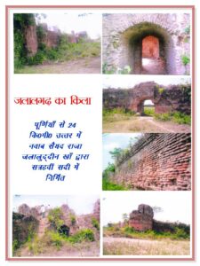
- Jalalgarh Fort: A historic fort known for its architectural grandeur and historical importance situated in Jalalgadh division.
- Puran Devi Temple: A revered temple dedicated to Goddess Durga, attracting devotees from across the region.
- The Kali Mandir of old Purnia city on the Saura River, the Maata Asthan in Chunapur, the Panchmukhi Temple in the line bazaar, the Rani Sati Mandir in Kasba, the Prahlad Stambh in Banmankhi, and the Dhima Shiv Mandir in Dhima, Banmankhi are some of the major Hindu temples in Purnea.
- Koshi River: The scenic beauty of the Kosi River and its surroundings draw visitors.
- Forests and Wildlife: The district has several green belts and areas rich in flora and fauna, providing a natural retreat for nature enthusiasts.
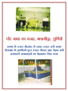
- The Darghah of Hazrat Mustafa Jamalul Haque Bandagi, Chimni Bazar, is also located in the city. Every year, on the seventh day following Eid-Ul-Azha, a “Urs” in the shape of a Mela (village fair) is held. This event lasts for three days.
- ‘Dargah and Khanquah Alia Mustafia’ is 7 kilometers from the city center. It is well-known for Sufism, spirituality, and tranquility throughout the community.
- It has 400 years of history, beginning when Hazrat Bandagi traveled from Jaunpur, Uttar Pradesh, to visit many Khanqahs and Dargahs throughout India, including the Pandawa Sharif, the Bihar Sharif, and others.
- Since its founding, the Darghah has been instrumental in promoting culture, education, charity, secularism, and spiritual energies throughout Northeast Bihar.
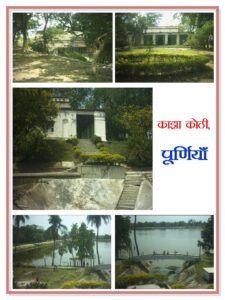
- Palace: The remains of Raja Kalanand Singh’s old Darbar (Palace), Kala Bhawan, are located at Deorhi near Garbanili (Purnea), where his successor still resides.
Transportation
- Railways: Purnia Junction and Purnia Court Railway Station connect the district to major cities like Patna, Kolkata, and Guwahati.
- Roadways: Purnia is well-connected through National Highways (NH-31, NH-57) and State Highways, facilitating transport to neighboring states and regions.
- Airport: Purnia has a small airport, Chunapur Air Force Base, which is occasionally used for civilian purposes. The nearest functional airport is Bagdogra Airport in West Bengal (about 150 km away).
Challenges
- Flooding: The district frequently suffers from floods caused by the Kosi and Mahananda rivers, which disrupt livelihoods and infrastructure.
- Infrastructure: Despite improvements, rural areas still lack adequate healthcare, education, and road connectivity.
- Employment: Limited industrial growth leads to migration, with many residents moving to other states for better job opportunities.
Conclusion
Purnia is a district of historical and cultural significance, with immense potential for agricultural and industrial development. While challenges like frequent flooding and underdeveloped infrastructure remain, the district’s strategic location, fertile lands, and cultural diversity make it a vital part of Bihar. With continued investments in education, disaster management, and industrialization, Purnia has the potential to emerge as a prominent economic and cultural hub in the region.
Would you like more details about any specific Topics on Bihar? Comment Below or checkout these topics
पूर्णिया जिला: विविधता और समृद्ध विरासत की विशेष भूमि
अवलोकन
पूर्णिया जिला, जिसे अक्सर “पूर्वोत्तर भारत का प्रवेश द्वार” कहा जाता है, बिहार के 38वें सबसे पुराने जिलों में से एक है, जिसका ऐतिहासिक, सांस्कृतिक और आर्थिक महत्व समृद्ध है। बिहार के पूर्वोत्तर भाग में स्थित पूर्णिया अपनी कृषि उत्पादकता, विविध संस्कृति और रणनीतिक भौगोलिक स्थिति के लिए जाना जाता है। पूर्णिया जिले की सीमा उत्तर में अररिया, पूर्व में किशनगंज, दक्षिण में कटिहार तथा पश्चिम में मधेपुरा और सहरसा से लगती है। जिले का प्रशासनिक केंद्र पूर्णिया शहर में स्थित है। यह पूर्णिया संभाग के अंतर्गत आने वाले जिलों में से एक है।
यह जिला 3,229 km2 (1,247 वर्ग मील) के क्षेत्र में फैला हुआ है। पूर्णिया की स्थापना 14 फरवरी 1770 को एक जिले के रूप में हुई थी। 1947 से, पूर्णिया ने स्वतंत्रता दिवस पर सुबह 12:07 बजे राष्ट्रीय ध्वज फहराने की अपनी परंपरा को बनाए रखा है। 1976 में कटिहार, 1990 में अररिया और किशनगंज तीन जिले थे जिन्हें पूर्णिया जिले से अलग कर दिया गया था।
प्राचीन युग
वैदिक काल के उत्तरार्ध (लगभग 1100-500 ईसा पूर्व) से ही पूर्णिया जिला मिथिलांचल (मिथिला क्षेत्र) का हिस्सा रहा है। मिथिला को सबसे पहले तब प्रसिद्धि मिली जब इंडो-आर्यन वहां चले गए और मिथिला साम्राज्य की स्थापना की, जिसे विदेहों का साम्राज्य भी कहा जाता है। विदेह, कुरु और पंचाल दक्षिण एशिया के संस्कृति और राजनीति के प्रमुख केंद्रों के रूप में उभरे। विदेह साम्राज्य के शासकों को जनक के नाम से जाना जाता था। विदेह साम्राज्य को अंततः वज्जि संघ में शामिल कर लिया गया, जिसकी राजधानी वैशाली थी, जो मिथिला में ही स्थित थी।
अनस और पुंड्रा पूर्णिया में रहने वाले पहले लोग थे। जबकि आर्य वंश होने के बावजूद पुंड्रा को ऐतरेय ब्राह्मण, महाभारत और मनु संहिता में पवित्र संस्कारों के प्रति उपेक्षा के कारण निम्न वर्ग के लोगों के रूप में माना जाता था, अनास को महाकाव्यों में बंगाल जनजातियों के साथ समूहीकृत किया गया है और अथर्व संहिता काल के दौरान आर्यों के लिए ज्ञात सबसे पूर्वी जनजातियाँ थीं। महाभारत की पौराणिक कथाओं में कहा गया है कि पूर्णिया विराटनगर का स्थान है, जिसने अपने एक साल के गुप्त निर्वासन के दौरान पाँच पांडव भाइयों को शरण दी थी।
मुगल युग
मुगल साम्राज्य के दौरान पूर्णिया एक सैन्य सीमांत क्षेत्र था जो फौजदार के नियंत्रण में था। इस सुदूर क्षेत्र से प्राप्त धन का उपयोग पूर्वी और उत्तरी जनजातियों के खिलाफ सीमाओं की रक्षा के लिए सैनिकों को ड्यूटी पर रखने के लिए किया जाता था। आइन-ए-अकबरी के अनुसार, पूर्णिया बंगाली सूबा में एक सरकार थी। 1757 में, कलकत्ता की विजय के बाद पूर्णिया के स्थानीय गवर्नर ने सिराजुद्दौला के खिलाफ विद्रोह कर दिया। 1765 में, पूर्णिया को ईस्ट इंडिया कंपनी ने अधिग्रहित कर लिया और 10 फरवरी, 1770 को इसे एक जिले के रूप में स्थापित किया गया। सरसी यूरोपीय लोगों के अधीन एक प्रसिद्ध नील केंद्र था, लेकिन रामबाग एक प्रसिद्ध यूरोपीय उपनिवेश था। 20वीं सदी की शुरुआत में, पूर्णिया जिला स्वदेशी और किसान सभा आंदोलनों का एक प्रमुख स्थल था।
पूर्णिया का अतीत शानदार और इतिहास से भरा हुआ था। पुरैन, जिसका अर्थ है कमल, या देवी पूरन देवी (काली) को पूर्णिया नाम की उत्पत्ति माना जाता है। माना जाता है कि इस मंदिर ने पूर्णिया को अपना नाम दिया है। शहर के केंद्र से पाँच किलोमीटर दूर, माता पूरन देवी को समर्पित सबसे पुराना मंदिर पूर्णिया में एक और दिलचस्प जगह है। पूर्णिया में एक विशिष्ट रूप से निर्मित संस्थान, रामकृष्ण मिशन, अक्टूबर दुर्गा पूजा कार्यक्रम की मेजबानी के लिए प्रसिद्ध है। अन्य परिकल्पनाएँ भी बताती हैं कि पूर्णिया को इसका नाम कैसे मिला, अर्थात् इसे पहले पूर्णा-अरण्य के नाम से जाना जाता था, जिसका अनुवाद “पूर्ण जंगल” होता है।
पूर्णिया जिले के बारे में मुख्य तथ्य
- देश: भारत
- राज्य: बिहार
- क्षेत्र: मिथिला
- प्रमंडल: पूर्णिया
- निर्देशांक: 25.78°N 87.47°E
- स्थापना: 14 फरवरी 1770
- क्षेत्रफल: 3,229 km2 (1,247 वर्ग मील)
- जिला मुख्यालय: पूर्णिया
- जिला मजिस्ट्रेट (DM): कुन्दन कुमार, IAS
- जनसंख्या (2011):
- कुल: 3,264,619
- घनत्व: 1,000/km2 (2,600/वर्ग मील)
- साक्षरता दर: 72.09%
- लिंगानुपात: 921
- राजभाषा: हिन्दी
- क्षेत्रीय भाषा: मैथिल
- ग्राम पंचायतें: 246
- गांव: 1450 (लगभग)
- अनुमण्डल की संख्या: 4 (पूर्णिया सदर, धमदाहा, बायसी, बनमनखी)
- ब्लॉकों की संख्या: 14
- पूर्णिया सदर- पूर्णिया पूर्व, जलालगढ़, कसबा, कृत्यानंद नगर, श्रीनगर
- धमदाहा- धमदाहा, रूपौली, भवानीपुर, बड़हरा
- बैसी- अमौर, बैसा, बैसी, डगरुआ
- बनमनखी- बनमनखी
- पुलिस स्टेशन: 25
- (एसपी पूर्णिया, डीएसपी मुख्यालय,एसडीपीओ पूर्णिया,एसडीपीओ बौंसी,एसडीपीओ धमदाहा,एसडीपीओ बनमनखी) (थाना-भवानीपुर,कसबा,खजांची हाट,सदर,अनगढ़,सरसी,जानकीनगर,टीकामाही,मीरगंज,जलालगढ़,बरहरा कोठी,बनमनखी,रूपौली, धमदाहा, धबैसी, रौता, अमौर, कृत्यानंद नगर, डगरुआ)
- नगर निगम: 1 (पूर्णिया)
- नगर पंचायत: 2 (बनमनखी, कसबा नगर)
- नदियाँ: कोसी, महाने
- लोकसभा क्षेत्र: 1 (पूर्णिया)
- विधानसभा क्षेत्र: 7
- 56- अमौर, 57- बैसी, 58- कसबा, 59- बनमनखी, 60- रूपौली, 61- धमदाहा, 62- पूर्णिया
- मुख्य विशेषताएं:
- बिहार को पूर्वोत्तर राज्यों से जोड़ने वाली अपनी रणनीतिक स्थिति के कारण इसे “पूर्वोत्तर भारत का प्रवेश द्वार” के रूप में जाना जाता है।
- समृद्ध कृषि भूमि उत्पादन जूट, मक्का और धान।
- सांस्कृतिक रूप से जीवंत, लोक परंपराओं और आधुनिक प्रभावों का मिश्रण।
- महत्व: क्षेत्र में एक महत्वपूर्ण व्यापार और कृषि केंद्र।
- प्रमुख राजमार्ग: NH-27, NH-31, NH-231, NH-131A
- प्रमुख रेलवे लाइनें:
- बरौनी-कटिहार,सहरसा और पूर्णिया खंड
- बरौनी-गुवाहाटी लाइन
- स्वतंत्रता सेनानी: श्री जिबत्श शर्मा ‘हिमांशु’, फुलेश्वर प्रसाद यादव
- डाक पता: प्रधान डाकघर, गिरजा चोक के पास, पूर्णिया- 854301, फ़ोन: 18002666868
- समय क्षेत्र: UTC+05:30 (IST)
- वाहन पंजीकरण: BR-11
- एसटीडी कोड: 06454
- पिन कोड: 854301
- आधिकारिक वेबसाइट: purnea.nic.in
भूगोल
- स्थान: पूर्णिया बिहार के उत्तरपूर्वी भाग में स्थित है, जिसकी सीमा उत्तर में अररिया, पूर्व में किशनगंज, दक्षिण में कटिहार और पश्चिम में मधेपुरा और सहरसा से लगती है।
- क्षेत्र: जिला लगभग 3,229 वर्ग किलोमीटर में फैला हुआ है।
- नदियाँ:
- यह क्षेत्र कम ऊँचाई वाला है और ज़्यादातर समृद्ध, दोमट जलोढ़ मिट्टी से बना है। हिमालय से निकलने वाली प्रमुख नदियाँ जिले से होकर बहती हैं जिनमें कोसी, महानंदा, गंगा, सुवारा काली, कारी कोसी, सौरा, पनार और कोली शामिल हैं, जो सिंचाई और जल परिवहन के मामले में महत्वपूर्ण लाभ प्रदान करती हैं, लेकिन बाढ़ का खतरा भी पैदा करती हैं।
- कोसी के मार्ग में बदलाव के कारण जमा हुई रेत पश्चिम में मिट्टी के एक बड़े हिस्से को कवर करती है। यहाँ तीन मुख्य फ़सलें केला, मक्का और जूट पैदा होती हैं।
- जलवायु: पूर्णिया में गर्म ग्रीष्मकाल, भारी मानसूनी बारिश और ठंडी सर्दियाँ वाली आर्द्र उपोष्णकटिबंधीय जलवायु है।
इतिहास
- प्राचीन युग: इस जिले की ऐतिहासिक जड़ें मौर्य और गुप्त काल से जुड़ी हैं। ऐसा माना जाता है कि यह प्राचीन भारत में मिथिला और अंग क्षेत्र का हिस्सा था।
- औपनिवेशिक काल: ब्रिटिश शासन के दौरान, पूर्णिया ने एक प्रशासनिक इकाई के रूप में महत्व प्राप्त किया। यह पूरे पूर्वोत्तर बिहार क्षेत्र के मुख्यालय के रूप में कार्य करता था।
- गठन: पूर्णिया बिहार के सबसे पुराने जिलों में से एक है, जिसकी स्थापना 1770 में हुई थी, और इसने राज्य के प्रशासनिक और आर्थिक विकास में महत्वपूर्ण भूमिका निभाई है।
जनसांख्यिकी (2011 की जनगणना के अनुसार)
- जनसंख्या:
- कुल: पूर्णिया जिले की जनसंख्या 3,264,619 (लगभग 3.26 मिलियन) है, जो मॉरिटानिया (उत्तर पश्चिमी अफ्रीका में एक संप्रभु देश) की जनसंख्या के बराबर है।
- रैंकिंग: भारत में 105वाँ (640 जिलों में से)।
- जनसंख्या घनत्व: प्रति वर्ग किलोमीटर 1014 निवासी (2,380/वर्ग मील)।
- वृद्धि दर (2001-2011): 28.66%, जो जनसंख्या में उल्लेखनीय वृद्धि को दर्शाता है।
- साक्षरता दर: साक्षरता दर 51.08% है, जिसमें शहरी और ग्रामीण क्षेत्रों के बीच उल्लेखनीय असमानताएँ हैं।
- लिंग अनुपात: प्रत्येक 1000 पुरुषों पर 930 महिलाएँ, जो लैंगिक असमानता को दर्शाता है।
- शहरी जनसंख्या: कुल जनसंख्या का 10.51%।
- धार्मिक संरचना (2011 की जनगणना):
- हिंदू धर्म: 60.94%
- अनुसूचित जातियाँ: 11.98%
- अनुसूचित जनजातियाँ: 4.27%
- इस्लाम: 38.46%
- अन्य या नहीं बताया गया: 0.60%
- भाषाएँ: बोली जाने वाली मुख्य भाषाएँ मैथिली, हिंदी, उर्दू, सुरजापुरी, बंगाली, अंगिका और संथाली हैं, जो इस क्षेत्र की भाषाई विविधता को दर्शाती हैं।
- हिंदी: 33.68%
- उर्दू: 18.62%
- अन्य (हिन्दी के अंतर्गत): 18.53%
- मैथिली: 10.72%
- सुरजापुरी: 8.73%
- बंगाली: 4.51%
- संथाली: 2.50%
- अन्य: 2.71%
प्रशासन
- मुख्यालय: पूर्णिया शहर जिला मुख्यालय के रूप में कार्य करता है।
- उपखंड:
- जिले को चार उपखंडों में विभाजित किया गया है: पूर्णिया सदर, धमदाहा, बनमनखी और बैसी, जिन्हें आगे ब्लॉकों में विभाजित किया गया है।
- प्रत्येक उपखंड का नेतृत्व एक उपखंड मजिस्ट्रेट करता है जो विकास, राजस्व संबंधी कार्यों और कानून व्यवस्था बनाए रखने का प्रभारी होता है।
- ब्लॉक और सर्किल:
- पूर्णिया जिले को 11 ब्लॉक और सर्किल में विभाजित किया गया है।
- पूर्णिया सदर- पूर्णिया पूर्व, जलालगढ़, कसबा, कृत्यानंद नगर, श्रीनगर
- धमदाहा- धमदाहा, रूपौली, भवानीपुर, बड़हरा
- बैसी- अमौर, बैसा, बैसी, डगरुआ
- बनमनखी- बनमनखी
- प्रत्येक सर्किल का नेतृत्व एक सर्किल अधिकारी (सीओ) करता है, जबकि प्रत्येक ब्लॉक का नेतृत्व एक ब्लॉक विकास अधिकारी (बीडीओ) करता है।
- पूर्णिया जिले को 11 ब्लॉक और सर्किल में विभाजित किया गया है।
- शासन: पूर्णिया पूर्णिया डिवीजन के अंतर्गत आता है और इसका प्रतिनिधित्व बिहार विधानसभा और भारतीय संसद दोनों में होता है।
- लोकसभा क्षेत्र: पूर्णिया
- विधान सभा क्षेत्र: 7
- 56- अमौर, 57- बैसी, 58- कसबा, 59- बनमनखी, 60- रूपौली, 61- धमदाहा, 62- पूर्णिया
अर्थव्यवस्था
- कृषि: जिले की अर्थव्यवस्था मुख्य रूप से कृषि आधारित है। प्रमुख फसलों में चावल, गेहूं, मक्का, जूट, गन्ना और दालें शामिल हैं। उपजाऊ मिट्टी और पर्याप्त जल संसाधन इसे बिहार में एक प्रमुख कृषि केंद्र बनाते हैं।
- जूट उद्योग: पूर्णिया अपने जूट उत्पादन के लिए जाना जाता है और इसे कभी-कभी “बिहार की जूट राजधानी” भी कहा जाता है।
- व्यापार और वाणिज्य: यह जिला कृषि उपज और उपभोक्ता वस्तुओं के लिए एक क्षेत्रीय व्यापार केंद्र है। पश्चिम बंगाल और नेपाल से निकटता इसके वाणिज्यिक महत्व को बढ़ाती है।
- उभरते उद्योग: कृषि-उत्पादों और जूट से संबंधित लघु-स्तरीय उद्योग बढ़ रहे हैं, हालांकि बड़े पैमाने पर औद्योगीकरण अभी भी सीमित है।
- तेल और प्राकृतिक गैस निगम ने पूर्णिया बेसिन में प्राकृतिक गैस और कच्चे तेल के भंडार की खोज शुरू कर दी है। बेसिन के भंडार का अनुमान 465 मिलियन टन से अधिक है।
शिक्षा
पूर्णिया में सरकारी और निजी शैक्षणिक संस्थानों का मिश्रण है जो जिले की शहरी और ग्रामीण आबादी की जरूरतों को पूरा करते हैं:
- पूर्णिया विश्वविद्यालय: स्नातक और स्नातकोत्तर कार्यक्रम प्रदान करने वाला एक प्रमुख उच्च शिक्षा संस्थान।
- शैक्षणिक संस्थान:
- पूर्णिया कॉलेज पूर्णिया
- गवर्नमेंट पॉलिटेक्निक कॉलेज, पूर्णिया
- पूर्णिया इंजीनियरिंग कॉलेज, पूर्णिया
- पूर्णिया महिला कॉलेज
- तकनीकी और व्यावसायिक प्रशिक्षण: गवर्नमेंट पॉलिटेक्निक, पूर्णिया जैसे संस्थान तकनीकी शिक्षा और कौशल विकास प्रदान करते हैं।
- स्कूल: जिले में कई सीबीएसई और बीएसईबी से संबद्ध स्कूल हैं, जो साक्षरता और शैक्षिक परिणामों को बेहतर बनाने का प्रयास कर रहे हैं।
संस्कृति
- त्यौहार: पूर्णिया छठ पूजा, दुर्गा पूजा, दिवाली और ईद जैसे त्यौहारों को उत्साह के साथ मनाता है, जो इस क्षेत्र की विविध धार्मिक और सांस्कृतिक बनावट को दर्शाता है।
- भोजन: जिले का भोजन मैथिली और बंगाली परंपराओं में निहित है, जिसमें लिट्टी चोखा, दाल-पीठा, माछेर झोल (मछली करी) जैसे लोकप्रिय व्यंजन और रसगुल्ला और खाजा जैसी मिठाइयाँ शामिल हैं।
- कला और संगीत: पूर्णिया मैथिली कला, लोकगीत और पारंपरिक नृत्यों सहित मिथिला संस्कृति में योगदान देता है।
पर्यटन


पूर्णिया में ऐतिहासिक, धार्मिक और प्राकृतिक महत्व के कई स्थान हैं:
- जलालगढ़ किला: जलालगढ़ डिवीजन में स्थित एक ऐतिहासिक किला जो अपनी वास्तुकला की भव्यता और ऐतिहासिक महत्व के लिए जाना जाता है।
- पूरन देवी मंदिर: देवी दुर्गा को समर्पित एक पूजनीय मंदिर, जो पूरे क्षेत्र से भक्तों को आकर्षित करता है।
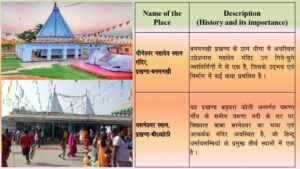
- सौरा नदी पर पुराने पूर्णिया शहर का काली मंदिर, चूनापुर में माता स्थान, लाइन बाजार में पंचमुखी मंदिर, कस्बा में रानी सती मंदिर, बनमनखी में प्रह्लाद स्तंभ और बनमनखी के धीमा में धीमा शिव मंदिर पूर्णिया के कुछ प्रमुख हिंदू मंदिर हैं।
- कोशी नदी: कोसी नदी और उसके आसपास की प्राकृतिक सुंदरता पर्यटकों को आकर्षित करती है।
- वन और वन्यजीव: जिले में कई हरित क्षेत्र और वनस्पतियों और जीवों से समृद्ध क्षेत्र हैं, जो प्रकृति प्रेमियों के लिए एक प्राकृतिक विश्राम स्थल प्रदान करते हैं।
- चिमनी बाजार में हजरत मुस्तफा जमालुल हक बंदगी की दरगाह भी शहर में ही स्थित है। हर साल ईद-उल-अजहा के बाद सातवें दिन मेले (गांव का मेला) के रूप में “उर्स” का आयोजन किया जाता है। यह आयोजन तीन दिनों तक चलता है।
- ‘दरगाह और खानकाह आलिया मुस्तफिया’ शहर के केंद्र से 7 किलोमीटर दूर है। यह पूरे समुदाय में सूफीवाद, आध्यात्मिकता और शांति के लिए प्रसिद्ध है।
- इसका इतिहास 400 साल पुराना है, जिसकी शुरुआत तब हुई जब हजरत बंदगी ने उत्तर प्रदेश के जौनपुर से यात्रा की और पूरे भारत में कई खानकाहों और दरगाहों का दौरा किया, जिनमें पांडवा शरीफ, बिहार शरीफ और अन्य शामिल हैं।
- अपनी स्थापना के बाद से, दरगाह पूरे पूर्वोत्तर बिहार में संस्कृति, शिक्षा, दान, धर्मनिरपेक्षता और आध्यात्मिक ऊर्जा को बढ़ावा देने में महत्वपूर्ण भूमिका निभा रही है।
- महल: राजा कलानंद सिंह के पुराने दरबार (महल), कला भवन के अवशेष, गर्बनिली (पूर्णिया) के पास देवढ़ी में स्थित हैं, जहाँ उनके उत्तराधिकारी अभी भी रहते हैं।
परिवहन
- रेलवे: पूर्णिया जंक्शन और पूर्णिया कोर्ट रेलवे स्टेशन जिले को पटना, कोलकाता और गुवाहाटी जैसे प्रमुख शहरों से जोड़ते हैं।
- सड़क मार्ग: पूर्णिया राष्ट्रीय राजमार्गों (NH-31, NH-57) और राज्य राजमार्गों के माध्यम से अच्छी तरह से जुड़ा हुआ है, जिससे पड़ोसी राज्यों और क्षेत्रों में परिवहन की सुविधा मिलती है।
- हवाई अड्डा: पूर्णिया में एक छोटा हवाई अड्डा, चूनापुर वायु सेना बेस है, जिसका उपयोग कभी-कभी नागरिक उद्देश्यों के लिए किया जाता है। निकटतम कार्यात्मक हवाई अड्डा पश्चिम बंगाल में बागडोगरा हवाई अड्डा (लगभग 150 किमी दूर) है।
चुनौतियाँ
- बाढ़: जिले में अक्सर कोसी और महानंदा नदियों के कारण बाढ़ आती है, जिससे आजीविका और बुनियादी ढाँचा बाधित होता है।
- बुनियादी ढाँचा: सुधारों के बावजूद, ग्रामीण क्षेत्रों में अभी भी पर्याप्त स्वास्थ्य सेवा, शिक्षा और सड़क संपर्क का अभाव है।
- रोजगार: सीमित औद्योगिक विकास के कारण पलायन होता है, कई निवासी बेहतर रोजगार के अवसरों के लिए दूसरे राज्यों में चले जाते हैं।
निष्कर्ष
पूर्णिया ऐतिहासिक और सांस्कृतिक महत्व का जिला है, जिसमें कृषि और औद्योगिक विकास की अपार संभावनाएं हैं। हालांकि लगातार बाढ़ और अविकसित बुनियादी ढांचे जैसी चुनौतियां बनी हुई हैं, लेकिन जिले की रणनीतिक स्थिति, उपजाऊ भूमि और सांस्कृतिक विविधता इसे बिहार का एक महत्वपूर्ण हिस्सा बनाती है। शिक्षा, आपदा प्रबंधन और औद्योगीकरण में निरंतर निवेश के साथ, पूर्णिया में इस क्षेत्र में एक प्रमुख आर्थिक और सांस्कृतिक केंद्र के रूप में उभरने की क्षमता है।
क्या आप बिहार के किसी विशेष विषय के बारे में अधिक जानकारी चाहते हैं? नीचे टिप्पणी करें
पदानुक्रमिक संरचना: बिहार का विस्तृत रोडमैप
बिहार में प्रमंडल और उसके जिलों का विवरण
Important Links
𝕋𝕙𝕒𝕟𝕜 𝕐𝕠𝕦 𝔽𝕠𝕣 𝕍𝕚𝕤𝕚𝕥𝕚𝕟𝕘 𝕆𝕦𝕣 𝕎𝕖𝕓𝕤𝕚𝕥𝕖𝕤 🙂
4 thoughts on “Purnia District: Special Land of Diversity and Rich Heritage”