
West Champaran District: An Overview
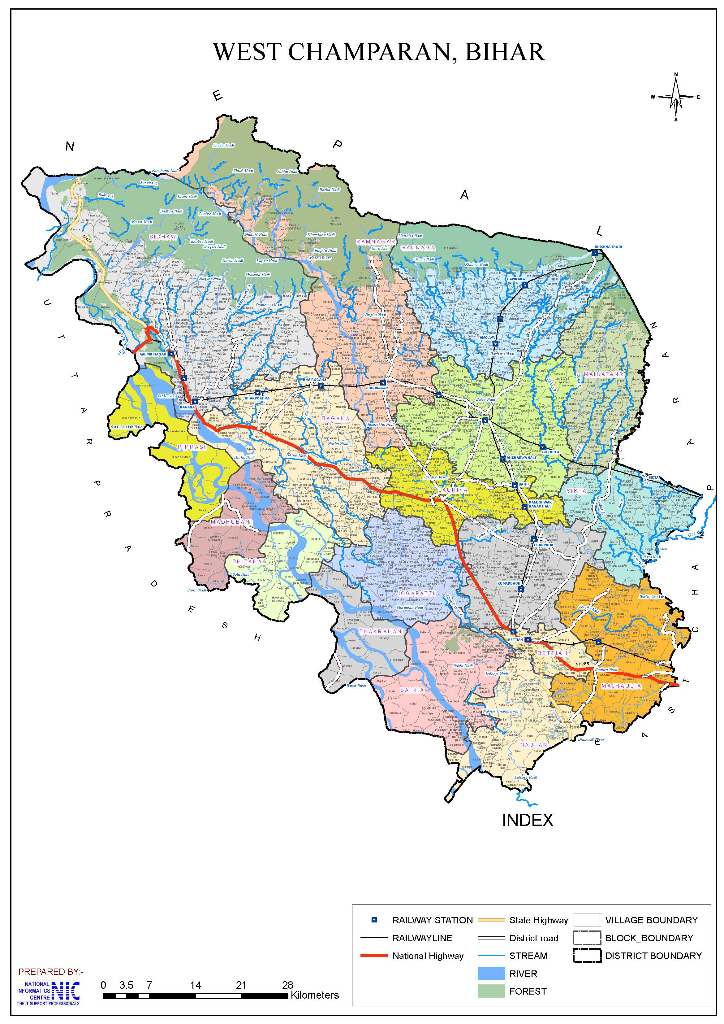
West Champaran District is one of the largest among 38-districts, located in north-western part of Bihar state, India, known for its historical importance, rich biodiversity, and agricultural prosperity. Spanning an area of 5,228 square kilometers (2,019 square miles), West Champaran lies at 26°16′ to 27°31′ N latitude and 83°50′ to 85°18′ E longitude, and shares borders with Hilly region of Nepal to the North, Gopalganj District and part of East Champaran District to the South, Maharajganj District and Kushinagar District of Uttar Pradesh to the West and East Champaran District to the East. The district’s administrative headquarters is located at Bettiah town. The region is part of the Tirhut Division.
The British administration formally established Champaran as an independent unit in 1866. However, in 1972, Champaran was divided into Purbi Champaran (East Champaran) and Paschim Champaran (West Champaran). Before that, it was a subdivision of Saran district and later became a part of Champaran district, with Bettiah as its headquarters. The town of Bettiah is believed to have derived its name from “Baint” (Cane) plants, which were once abundant in the region. The name Champaran itself originates from the Sanskrit words “Champaka Aranya”, meaning the Forest of Champa (Magnolia) trees, which once covered the area and served as a retreat for ascetics.
The district played a crucial role in Mahatma Gandhi’s Champaran Satyagraha (1917), which was India’s first major movement against British rule. It is also home to Valmiki National Park, Bihar’s only tiger reserve, and shares an international border with Nepal.
Ancient and Medieval History
Champaran’s early history is linked to the Videha Empire, which was ruled by King Janaka. After the fall of Videha, the region became part of the Vrijjan Republic, with Vaishali as its capital and the Lichchavis as the most powerful clan. During the 5th century BC, Ajatshatru, the emperor of Magadha, annexed the Lichchavi kingdom, including West Champaran, and brought it under Mauryan rule, where it remained for the next hundred years. Subsequently, it came under the Sunga and Kanva dynasties, followed by the Kushan and Gupta Empires.
In the 7th century AD, the famous Chinese traveler Hiuen Tsang visited India during the reign of Harsha, when Champaran was possibly part of Tirhut. Between 750 and 1155 AD, the Palas of Bengal ruled over the region. Later, Gangaya Deva of the Kalachuri dynasty conquered Champaran, and his successor Vikramaditya of the Chalukya dynasty continued to rule.
Islamic Rule and the Mughal Era
The first Muslim influence in Champaran occurred between 1213 and 1227, when Ghiyasuddin Iwaz, the governor of Bengal, extended his control over Tirhut. However, his conquest was incomplete, and he could only secure the region through agreements with Narsinghdeva, the ruler of Simraon. In 1320, Ghiyasuddin Tughlaq annexed Tirhut and placed it under Kameshwar Thakur, who founded the Sugaon (Thakur) dynasty. This dynasty ruled Champaran until 1530, when Nasrat Shah, the son of Alauddin Shah, annexed the territory and ended the Thakur dynasty’s rule. He appointed his son-in-law as the viceroy, and from then on, Champaran remained under Muslim rule.
During the late medieval period, Bettiah Raj emerged as a powerful estate. It traces its origins to Ujjain Singh and his son Gaj Singh, who received the title of Raja from Mughal Emperor Shah Jahan (1628–1658). The estate grew in prominence during the decline of the Mughal Empire, and by the time the British took control of Champaran, it was ruled by Raja Jugal Kishore Singh, who succeeded Raja Dhurup Singh in 1763. The estate continued under his descendants, with Maharaja Harendra Kishore Singh being the last ruler. After his death in 1893, the estate passed to his first wife, who died in 1896.
Subsequently, the property came under the management of the Court of Wards in 1897 and remained under the control of Maharani Janki Kuar.
The Bettiah Raj Palace, which occupies a significant area in Bettiah town, was built in 1910 at the request of the Maharani. It was designed to resemble Graham’s Palace in Calcutta and remains a historical landmark.
Champaran Satyagraha and the Role of West Champaran in India’s Freedom Movement
In the early 20th century, Bettiah became a hub of nationalism, primarily due to indigo cultivation and British oppression. A local farmer and activist, Raj Kumar Shukla, met Mahatma Gandhi and narrated the plight of the raiyats (tenant farmers) under the British indigo planters. Moved by their suffering, Gandhi visited Champaran in 1917 and began his first Satyagraha movement, marking the beginning of India’s mass civil disobedience against British rule.
The Champaran Satyagraha successfully ended the forced indigo cultivation system, liberating farmers from British exploitation. By 1918, the long-standing oppression of indigo cultivators had come to an end, and Champaran became a symbol of India’s independence movement. Gandhi’s successful experiment in Champaran provided the launchpad for the broader struggle for freedom across India.
West Champaran has a rich historical legacy, from being part of ancient kingdoms like Videha and Vaishali to becoming a stronghold of Mughal and British rule. The Bettiah Raj played a key role in the region’s governance, and the Champaran Satyagraha of 1917 turned the district into the epicenter of India’s independence movement. Today, West Champaran remains a land of historical, cultural, and political significance, deeply intertwined with the nation’s past and its journey toward freedom.
Key Facts About West Champaran District
- Country:
 India
India - State:
 Bihar
Bihar - Region: Mithila
- Division: Tirhut
- Established: 1972
- Area: 5,228 km2 (2,019 sq mi)
- Coordinates: 26°48′N 84°30′E
- District Headquarters: Bettiah
- Population (2011):
- Total: 3,935,042
- Density: 750/km2 (1,900/sq mi)
- Literacy Rate: 58.06%
- Sex Ratio: 906/1000
- Gram Panchayats: 315
- Villages: 1483
- No. of Blocks: 18
- Bettiah, Sikta, Mainatanr, Chanpatia, Bairia, Lauriya, Bagaha, Sidhaw, Madhubani, Gaunaha, Narkatiaganj, Manjhaulia, Nautan, Jogapatti, Ramnagar, Thakraha, Bhitaha and Piprasi
- Police Station: 50
- Manuapool, Banuchappar, Majhaulia, Chanpatia, Gopalpur, Yogapatti, Nawalpur, Sanichari, Nautan, Jagdispur, Bairiya, Srinagar, Shikarpur, Sathi, Lauriya, Gauhaha, Sahodara, Matyariya, Mainatand, Purshotampur, Inarwa, Bhangaha, Manpur, Balthar, Sikta, Kangali, Bagaha, Chautarwa, Bhairoganj, Naurangiya, Valmikinagar, Dhanha, Thakrahan, Piprasi, Bhitaha (O.P), Patkhauli (O.P), Chiutahan (O.P), Kalibagh (O.P), Sirisiya (O.P), Ramnagar, Gobardhana, Gobrahiya, Bathwariya, Semra, Laukariya, Nagar P.S, Mufassil, Mahila P.S, SC/ST P.S.
- No. of Subdivision (Tehsil): 3 (Bettiah, Bagaha, Narkatiaganj)
- Municipal corporation (Nagar Nigam): 1 (Bettiah)
- Municipal Council (Nagar Parishad): 3 (Ramnagar, Narkatiaganj, Bagaha)
- Nagar Panchayats: 3 (Chanpatia, Lauriya, Machhargawan)
- Vidhan Sabha constituencies: 9
- Valmiki Nagar, Ramnagar, Narkatiaganj, Bagaha, Lauriya, Nautan, Chanpatia, Bettiah, Sikta.
- Lok Sabha constituency: 2 (Paschim Champaran, Valmiki Nagar)
- Key Features:
- Known for the Valmiki National Park, which is home to Bengal tigers and other wildlife.
- Rich in natural beauty with forests and rivers.
- Historically linked to the Bettiah Raj (a prominent zamindari estate).
- Significance: A district of ecological and historical importance.
- Time Zone: UTC+05:30 (IST)
- PIN Code: 8454XX
- Major Highways: NH-28B
- Official Website: westchamparan.nic.in
Geography
West Champaran, located in the northern part of Bihar, is rich in agricultural land, forests, and water bodies. It has a diverse landscape, ranging from hilly terrains and Terai regions to fertile plains. The district also experiences heavy rainfall, making it suitable for agriculture and wildlife conservation.
- Location: West Champaran is located in north-western Bihar and shares its borders with:
- Hilly region of Nepal to the North
- East Champaran District to the East
- Gopalganj District & part of East Champaran District to South
- Maharajganj District & Kushinagar District of Uttar Pradesh to the West
- Area: 5,229 square kilometers, making it the largest district in Bihar.
Border Connection with Nepal 🇮🇳🇳🇵
- The district shares a 35 km-long border with Nepal.
- The international border touches five blocks of East Champaran:
1️⃣ Bagaha-II
2️⃣ Ramnagar
3️⃣ Gaunaha
4️⃣ Mainatand
5️⃣ Sikta - The border extends from the northwest corner to the southeast of the district.
Land Use Pattern 🌾🏞️
The district has 1,196,819 acres of land, categorized as follows:
| Land Type | Area (in acres) |
|---|---|
| 🌳 Forest Land | 226,790 |
| 🌾 Agricultural Land | 515,097 |
| 🏗️ Non-Agricultural Land | 68,283 |
| 💦 Land Under Water | 173,078 |
| 🏡 Homestead Land | 184,764 |
Major Crops Grown
West Champaran produces three types of crops based on seasonal variations:
- Bhadai (Autumn crop) – Maize, Sugarcane
- Aghani (Kharif crop) – Paddy, Potato
- Rabi (Spring crop) – Wheat, Barley, Arhar (Cajamus Indicus)
- Low-lying northern lands are mainly used for paddy cultivation.
Natural Divisions & Terrain 🌍
West Champaran can be divided into distinct geographical regions:
1️⃣ Hilly Region (Someshwar & Dun Ranges) 🏔️
- Located in the north, at the foothills of the Himalayas.
- No rocky formations, making farming possible with proper water management.
- Rich in forests, but suffers from soil erosion due to streams carrying sand.
2️⃣ Terai Region 🌿
- Located below the hilly area and inhabited by the Tharu tribe.
- The region is fertile but prone to flooding.
3️⃣ Fertile Plains 🌾
- The majority of the district consists of these plains.
- Divided by Little Gandak River into:
- Northern portion – Old alluvial soil, with low-lying lands and streams.
- Southern portion – Uplands with large marshy depressions (Chaurs).
Major Rivers
- Gandak (Narayani) – A lifeline for irrigation & agriculture.
- Sikrahana (Little Gandak) – Flows through the district.
- Burhi Gandak River
- Harha River
Climate & Rainfall 🌦️
- Cooler & damper than neighboring districts.
- Unhealthy climate in the Terai region (Ramnagar, Bagaha, Narkatiaganj) due to high humidity.
- Seasons:
- Winter (Nov – Feb): Cold & dry, temperature drops to 6°C.
- Summer (March – June): Hot, temperatures rise to 43°C.
- Monsoon (June – Sept): Heavy rains begin late June.
- Annual Rainfall: 56 inches (higher than most districts).
Mines & Minerals ⛏️
- Dun & Someshwar Hills – Ill-compacted sandstone.
- Kankar (Limestone) deposits found in some parts.
- Saltpetre – Found across the district, used for gunpowder & fertilizers.
Forests, Wildlife & Biodiversity 🌳🐯
1️⃣ Flora (Plant Life) 🌿
- Forests mainly in northern regions (Someshwar & Dun Hills).
- Common trees: Sal, Sheesham, Tun, Khair.
- Terai region has bamboo groves, sabai grass, and narkat reeds.
2️⃣ Fauna (Animal Life) 🦁🐘
- Valmiki National Park (336 km²) – Home to Bengal tigers 🐅.
- Udaypur Wildlife Sanctuary – Rich in biodiversity.
- Common animals:
- Big Cats – Tiger, Leopard, Panther.
- Herbivores – Nilgai, Deer (Sambar), Bison, Wild Goats.
- Other Wildlife – Monkeys (Black & Red-faced), Wild Pigs, Wolves, Bears.
3️⃣ Birds & Fish
- Rare quails: Bustard, Button, Little Button (Amazonian species).
- Other birds: Brown Flycatchers, Grey Shrike, Olive Green Birds, Mynas.
- Fish species: Rohu, Catla, Tengra, Hilsa, Barari, Naini, Sauri.
- Snakes & occasional crocodiles found in large rivers.
Irrigation & Water Management 🚰
West Champaran has a well-developed canal system, fed by the Gandak River.
Major Canals 🚜
1️⃣ Tirhut Canal
2️⃣ Tribeni Canal
3️⃣ Done Canal
- These canals originate from Balmikinagar, at the Indo-Nepal border.
- They supply water to farmlands across the district.
History
Ancient Period
- The region was part of the Videha Kingdom and later the Magadha Empire.
- It has references in Hindu epics like Ramayana, where Valmiki Ashram is believed to be the place where Goddess Sita took refuge.
Medieval Period
- Ruled by various dynasties like the Mauryas, Guptas, and Mughals.
- It was a strategic trade route between India and Nepal.
Modern Era
- Champaran Satyagraha (1917):
- Mahatma Gandhi started his first mass movement here to protest against the British-imposed indigo farming system.
- The movement led to the abolition of forced indigo cultivation, marking a turning point in India’s freedom struggle.
- Formation of the District:
- West Champaran district was carved out of the old Champaran district in 1972 as part of Bihar’s administrative reorganization.
Demographics (As per 2011 Census)
- Population:
- Total Population: West Champaran district has a population of approximately 3,935,042.
- Ranking: 63rd in India (out of 640 districts).
- Density: 750 persons per square kilometer (1,900/sq mi).
- Population Growth (2001–2011): 28.89% reflecting significant population increase.
- Sex Ratio: 906 females per 1,000 males, indicating a gender disparity.
- Literacy Rate: 58.06%, which is below the national and state average but with significant efforts being made to improve education access and quality.
- Urban Population: 9.99% of the total population lives in urban areas.
- Religious Composition (2011 Census): The majority of the population follows Hinduism, with a significant Muslim community.
- Hinduism: 77.44%
- Scheduled Castes: 14.08%
- Scheduled Tribes: 6.35%
- Islam: 21.98%
- Other or not stated: 0.58%
- Languages: Hindi, Bhojpuri, Maithili, and Urdu are widely spoken.
- Bhojpuri: 91.86%
- Hindi: 3.32%
- Urdu: 2.97%
- Bengali: 0.99%
- Others: 0.86%
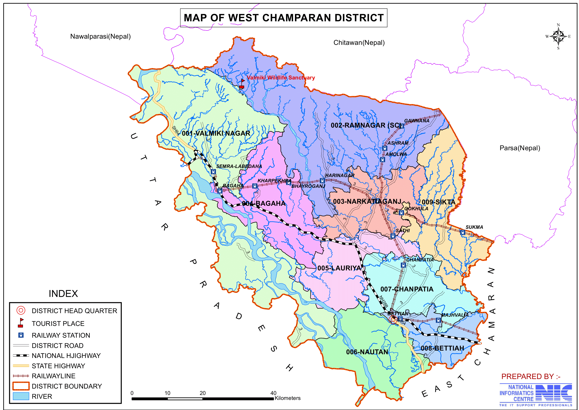
Administration
- Headquarters: Bettiah
- Subdivisions:
- The district has three subdivisions: Bettiah, Narkatiaganj and Bagaha.
- Each subdivision is led by a subdivisional magistrate who is in charge of development, revenue-related tasks, and maintaining law and order.
- Blocks and Circles:
- West Champaran district comprises 18 administrative Blocks and Circles such as Bettiah, Sikta, Mainatanr, Chanpatia, Bairia, Lauriya, Bagaha, Sidhaw, Madhubani, Gaunaha, Narkatiaganj, Manjhaulia, Nautan, Jogapatti, Ramnagar, Thakraha, Bhitaha and Piprasi, each responsible for local governance and development.
- A Circle officer (CO) leads each circle, while a Block Development Officer (BDO) leads each block.
- Lok Sabha Constituencies:
- Paschim Champaran Lok Sabha seat represents the district.
- Vidhan Sabha Constituencies:
- The district has 9 assembly constituencies are: Valmiki Nagar, Ramnagar, Narkatiaganj, Bagaha, Lauriya, Nautan, Chanpatia, Bettiah, Sikta.
Organization Chart

Economy 🌾🏭
West Champaran’s economy is primarily agriculture-based, with significant contributions from agro-industries, livestock farming, trade, and commerce. The district benefits from rich natural resources, including forests, fertile lands, and a strategic location bordering Nepal, making it a hub for cross-border trade.
1️⃣ Agriculture & Agro-Based Industries 🌿
- Primary source of income for the people of West Champaran.
- Agriculture is the backbone of the economy, with major crops including:
- Sugarcane (largest producer in Bihar)
- Paddy, wheat, maize, lentils, and oilseeds
- Fruits like mangoes, bananas, and guavas.
- Challenges:
- Flooding from rivers damages crops.
- Need for better irrigation and storage facilities.
Major Sugar Mills 🏭
- Agro-based industries such as sugar mills and rice mills play a vital role in the economy.
- Several sugar mills, including in Bettiah, Narkatiaganj, and Bagaha.
- 🚜 Operational Sugar Mills: Majhaulia, Bagaha, Ramnagar and Narkatiaganj
- 🚧 Closed Sugar Mills: Chanpatia and Lauria
Other Agro-Based Industries 🌾
✅ Rice Mills – Producing rice for export and domestic markets.
✅ Handicrafts & Cottage Industries: – Using local raw materials to produce:
- Gur (raw sugar), Basket weaving, Rope making and Mat weaving
- Bamboo and jute products are locally made.
2️⃣ Livestock & Dairy Farming 🐄
Livestock plays a crucial role in farming & dairy production in West Champaran.
Key Features:
Plough cattle – Locally bred, used for farming.
Bullocks – Strong and well-conditioned, used for cart transportation.
Buffaloes – The primary source of milk, though smaller in size compared to other regions.
Opportunities in Dairy Farming 🥛
- Potential for large-scale dairy farming & milk production.
- Buffalo milk processing & dairy-based industries can boost the local economy.
3️⃣ Trade & Commerce 🛒
West Champaran has strong trade links with Nepal due to its long shared border. This makes it a key center for Indo-Nepal trade.
Major Trade Goods
- 📥 Imports from Nepal: Rice, Timber and Spices
- 📤 Exports to Nepal: Textiles, Petroleum products and Other essential goods
Key Trade Centers 🚛
- Bagaha, Bettiah, Chanpatia and Narkatiaganj
West Champaran Important for Business & Trade because
- Rich in natural resources – Timber, fertile lands, livestock.
- Cross-border trade with Nepal boosts commerce.
- Growing agro-industries provide employment & economic growth.
- Strategic location with roads & railway connectivity.
Education
Higher Educational Institutions
- Maharani Janki Kunwar (M.J.K) College, Bettiah – One of the oldest colleges in Bihar.
- Government Medical College, Bettiah, West Champaran
- Ram Lakhan Singh Yadav College, Bettiah – A leading educational institution.
- Several government and private schools, but higher education opportunities remain limited.
- St. Teresa School, Bettiah, West Champaran
- S.S. Girls High School, Bettiah, West Champaran
- Kedar Pandey High School, Bettiah, West Champaran
- Kendriya Vidyalaya, Industrial area, Bettiah, West Champaran
- Notre Dame Public School, Belbagh, Bettiah, West Champaran
- St. Joseph’s School, Kamalnath Nagar, Bettiah, West Champaran
- Kidzee Play School, Kamalnath Nagar, Bettiah, West Champaran
- Raj Enter Secondary School, Lal Bazar, Bettiah, West Champaran
- Delhi Public School, Moharram Chowk, Bettiah, West Champaran
- Bipin High School, Collectorate Chowk, Bettiah, West Champaran
- Sacred Heart High School, Banuchhapar, Bettiah, West Champaran
- Alok Bharti Shikshan Sansthan, Lal Bazar, Bettiah, West Champaran
- Sarsawati Vidya Mandir, Bettiah Barwat Sena, Bettiah, West Champaran
- Krishna International Public School, Barwat Sena, Bettiah, West Champaran
- St Michael’s Academy, Chhawani (Mehandiyabari), Bettiah, West Champaran
- National Public Higher Secondary School, Indrapuri Colony, Bettiah, West Champaran
- Assembly of God Church School, AG Church Rd, Hathikhana, Bettiah, West Champaran
- Khrist Raja High School, Bel Bagh Colony, Subhash Nagar, Hathikhana, Bettiah, West Champaran
- Amna Urdu High School, Chawani Road, Near Uttarwari Pokhra, Chawani, Bettiah, West Champaran
Challenges
- Low literacy rate, especially in rural areas.
- Many students migrate to Patna or Muzaffarpur for higher education.
Culture
West Champaran is a culturally rich region in Bihar, known for its folk traditions, vibrant festivals, and delicious cuisine. The district’s art, music, dance, and culinary heritage reflect its deep-rooted traditions and historical significance.
Festivals & Celebrations 🎊🙏
West Champaran celebrates several festivals with great enthusiasm, uniting people from different communities.
Chhath Puja ☀️🌊
- The most significant festival of West Champaran, dedicated to Surya Dev (Sun God).
- The only Hindu festival where the setting sun is worshipped.
- Celebrated twice a year:
- Chaitra Chhath (March-April).
- Kartik Chhath (October-November).
- A four-day festival with strict rituals:
- Holy bathing, fasting, and standing in water for long hours.
- Offering ‘Arghya’ (water offerings) to the rising and setting sun.
- Singing folk songs in honor of Chhathi Maiya and Surya Dev.
- Women (Parvaitins) fast for the well-being of their families.
- Men also actively participate in the festival.
Other Important Festivals
- Makar Sankranti – Celebrated with kite flying and feasting on sesame sweets.
- Holi – The festival of colors, marking the arrival of spring.
- Durga Puja – A grand festival dedicated to Goddess Durga, celebrated with processions and cultural programs.
- Diwali and Eid are also celebrated.
- Champaran Mahotsav – An annual festival celebrating the region’s cultural heritage.
Famous Cuisine & Sweets 🍛🍬
- Delicious Traditional dishes include:
- Litti Chokha, Sattu Paratha, Dal Pitha
- Champaran Meat (Ahuna Mutton) is a famous delicacy from the region.
- Most famous sweets and snacks include:
- Chhena Murki – A sweet made from paneer (chhena) and sugar syrup.
- Kesaria Peda – A saffron-flavored milk-based sweet.
- Khaja – A crispy, layered, deep-fried sweet.
- Malpua – A traditional Indian pancake made with flour, milk, and sugar.
- Khurma – A sweet snack made from flour and sugar syrup.
- Thekua – A crispy and flavorful snack, often made during Chhath Puja.
- Tilkut – A winter delicacy made with sesame seeds and jaggery.
- Murabba – A sweet fruit preserve.
Folk Music & Dance 🎶💃
- Traditional folk songs are an integral part of West Champaran’s cultural identity.
- These songs are performed on various occasions, including weddings, festivals, and religious ceremonies.
- Jhumari Dance:
- A widely loved dance form performed by married women.
- This dance expresses joy, devotion, and celebration.
Tourism
West Champaran and its neighboring regions are rich in natural beauty, historical significance, and spiritual heritage and and wildlife tourism destination. Here’s an overview of some must-visit tourist attractions:
1. Valmikinagar (Bhainsa Lotan)
- Overview:
Formerly known as Bhainsa Lotan, Valmikinagar is a renowned tourist spot where a dam has been built on the Gandak River as part of the Gandak Project. - Features:
- The dam and its irrigation channels are the lifeline of northwestern Bihar and eastern Uttar Pradesh.
- The dam also generates hydroelectricity.
- It was handed over to the nation by the late Pandit Jawaharlal Nehru.
- Attractions:
- Explore the sylvan surroundings where the gushing streams of the Gandak enhance the scenic beauty of the Himalayan foothills.
- Valmiki National Park & Tiger Reserve: Bihar’s only tiger reserve and home to diverse wildlife.
- Visit the Valmikinagar Barrage and the Valmikinagar Hydel Project.
- Nearby, you can also visit the Valmiki Ashram—
- Traditionally believed to be where Maharshi Valmiki spent some years—and ancient Shiv-Parvati temples built by the Bettiah Raj.
- Believed to be the place where Sita stayed after exile.
2. Bank of Triveni (Confluence)
- Overview:
Located in the northwestern part of the district under Bagaha-II Block, about 5 miles above the Valmikinagar dam. - Features:
- This is the confluence of three rivers: Gandak, Panchanand, and Sonaha.
- The confluence lies at the Indo-Nepal border—one bank touches Triveni village in Nepal, and the other extends to Bhaisalotan village in India.
- Legend & Festivals:
- According to the Srimad Bhagwat, a legendary battle between an elephant and a crocodile began here, with Lord Vishnu protecting the elephant.
- Every year, on the eve of Magh Sankranti (a bathing festival when the sun enters a new zodiac sign), thousands of devotees take a holy dip in this confluence, making it a vibrant religious fair.
3. Bawangarhi (Tripan Bazar)
- Overview:
Bawangarhi, meaning “52 forts,” refers to the remains of old fortifications near Darwabari in Bagaha-II Block, about 8 km from Tribeni. - Features:
- Also known as Tripan Bazar, the area contains the remnants of 52 forts and 53 bazaars.
- Massive embankments, possibly built as reservoirs, can be seen across the swamp.
- Historical Note:
- Though legends abound, no trustworthy historical records fully explain Bawangarhi’s origins.
4. Bhiknato Hari (Bhiknato Hari)
- Overview:
A scenic spot in the Gaunaha block on the northern part of the district. - Features:
- It is the last railway station on the Narkatiaganj–Bhiknato Hari section.
- The area offers panoramic views of the snow-capped Himalayas and Annapurna peaks during winter.
- Historically, King George V visited this location for hunting, and an attractive bungalow still exists as a reminder of that era.
5. Sumeswer
- Overview:
A ruined fort located on the summit of the Sumeswer Hills in the Ramnagar block, standing at 2,884 feet above sea level. - Features:
- The fort, though in ruins, has clearly defined remains.
- Reservoirs carved out of solid rock indicate ancient water storage systems.
- From the ridge, one can enjoy a magnificent view of the snow-capped peaks, intervening valleys, and low hills in Nepal.
- The ridge marks the boundary between West Champaran and Nepal, with stunning views of peaks like Dhoulagiri, Gosainthan, and Gaurishanker.
6. Brindavan
- Overview:
Located about 10 km from Bettiah in Gaunaha Block, Brindavan is a historically significant village. - Features:
- In 1937, it hosted the annual conference of the All India Gandhi Seva Sangh, attended by Mahatma Gandhi, Dr. Rajendra Prasad, and Shri J.B. Kripalani.
- A basic school founded by Mahatma Gandhi still operates here, adding to the site’s cultural heritage.
7. Bhitiharawa Ashram
- Overview:
A village in the Gaunaha block that is historically important as the starting point of Gandhiji’s freedom movement known as Champaran Satyagraha. - Features:
- The village houses Gandhiji’s hut, now known as the Ashram, making it a key destination for Gandhian pilgrimage.
8. Nandangarh and Chankigarh
- Overview:
- Nandangarh is located in the Lauria Block, while Chankigarh is in the Narkatiaganj Block.
- Historical Significance:
- These two large mounds are believed to be the remains of palaces from the Nanda Dynasty and possibly the ashes stupa where Buddha’s ashes were enshrined.
- They also connect to ancient legends about Chanakya, the famed economist.
9. Saraiya Man
- Overview:
A picturesque lake situated about 6 km from Bettiah town. - Features:
- The lake is renowned for its salubrious water, enhanced by black berries (Jamun) planted on its banks, which are believed to aid digestion.
- It is a popular beauty spot attracting a variety of birds, making it ideal for nature lovers and bird watchers.
Why Explore These Attractions?
- Rich Historical and Cultural Heritage: Each site tells a part of the story of Bihar’s ancient civilizations, religious movements, and colonial history.
- Natural Beauty: From serene lakes and lush greenery to panoramic views of the Himalayas, the region is a haven for nature enthusiasts.
- Spiritual Significance: Many sites are connected with Buddhist, Hindu, and Gandhian legacies, offering a unique insight into India’s diverse cultural tapestry.
- Weekend Getaways: These attractions are perfect for family and friend trips, providing a mix of education, recreation, and spirituality.
Transportation
Roadways 🚌
- National Highways NH-727 and NH-28B connect West Champaran to Patna, Muzaffarpur, and Nepal.
- State and private buses operate frequently.
Railways 🚆
- Total Length of the Railways tracks within the district – 220 Kms
- Bettiah Railway Station – A key railway hub.
- Narkatiaganj Junction – Connects Bihar to Uttar Pradesh and Nepal.
Airways ✈️
- Nearest Airport:
- Darbhanga Airport (140 km away) for domestic flights.
- Patna Airport (200 km away) for better connectivity.
Notable Personalities
- Manoj Bajpayee – Acclaimed film actor known for his versatile performances in Indian cinema.
- Vinay Bihari – Actor and lyricist recognized for his contributions to regional theatre and films.
- Mahatma Gandhi – The eminent freedom fighter who initiated the Champaran Satyagraha, marking a turning point in India’s independence movement.
- Sanjay Jaiswal – Politician actively involved in regional governance and public affairs.
- Prakash Jha – Renowned film director celebrated for his impactful social and political dramas.
- Manish Jha – Film director and theatre actor known for his creative storytelling and stage performances.
- Sanjeev K. Jha – Scriptwriter and filmmaker who has contributed to the contemporary film narrative.
- Sunil Kumar Kushwaha – Member of Parliament, playing an active role in national politics.
- Baidyanath Prasad Mahto – Politician and Member of Parliament, influential in local and state politics.
- Krishna Kumar Mishra – Politician dedicated to public service and governance.
- Vikas Mishra – Economist noted for his contributions to economic analysis and policy.
- Gopal Singh Nepali – Hindi poet whose works reflect the cultural and literary heritage of the region.
- Gauri Shankar Pandey – Politician engaged in shaping regional policy and development.
- Kedar Pandey – Former Chief Minister of Bihar, recognized for his leadership in state governance.
- Raghaw Sharan Pandey – Retired IAS officer and former Union Petroleum Secretary, later involved in politics.
- Damodar Raao – Film music director, actor, and singer celebrated for his contributions to the music and film industry.
- Valmiki Rishi – The legendary ascetic traditionally credited as the author of the Hindu epic Ramayana, whose life and works remain an enduring inspiration in the cultural landscape.
These personalities reflect the rich cultural, political, and artistic legacy of the region, contributing significantly to its historical and contemporary narrative.
Challenges
- Flooding & Waterlogging – Causes major damage to crops and infrastructure.
- Unemployment & Migration – Lack of industries leads to outmigration.
- Infrastructure Development – Need for better roads, healthcare, and education.
- Education – The low literacy rate requires urgent improvement.
Conclusion
West Champaran is historically, agriculturally, and environmentally significant. It is famous for Champaran Satyagraha, Valmiki National Park, and sugarcane farming. However, flooding, unemployment, and lack of industries remain challenges. Investment in education, tourism, and industrial development can transform West Champaran into a leading district in Bihar.
Would you like more details about any specific Topics on Bihar? Comment Below or Checkout these topics
पश्चिमी चंपारण जिला: इतिहास, स्वतंत्रता और वन्य जीवन की एक विशेष भूमि
अवलोकन
पश्चिमी चंपारण जिला भारत के बिहार राज्य के उत्तर-पश्चिमी भाग में स्थित 38-जिलों में से सबसे बड़ा है, जो अपने ऐतिहासिक महत्व, समृद्ध जैव विविधता और कृषि समृद्धि के लिए जाना जाता है। 5,228 वर्ग किलोमीटर (2,019 वर्ग मील) के क्षेत्र में फैला पश्चिमी चंपारण 26°16′ से 27°31′ उत्तरी अक्षांश और 83°50′ से 85°18′ पूर्वी देशांतर पर स्थित है, और उत्तर में नेपाल के पहाड़ी क्षेत्र, दक्षिण में गोपालगंज जिला और पूर्वी चंपारण जिले के कुछ हिस्से, पश्चिम में उत्तर प्रदेश के महाराजगंज जिले और कुशीनगर जिले और पूर्व में पूर्वी चंपारण जिले के साथ सीमा साझा करता है। जिले का प्रशासनिक मुख्यालय बेतिया शहर में स्थित है। यह क्षेत्र तिरहुत प्रमंडल का हिस्सा है।
ब्रिटिश प्रशासन ने औपचारिक रूप से चंपारण को 1866 में एक स्वतंत्र इकाई के रूप में स्थापित किया। हालाँकि, 1972 में चंपारण को पूर्वी चंपारण और पश्चिम चंपारण में विभाजित किया गया था। इससे पहले, यह सारण जिले का एक उपखंड था और बाद में चंपारण जिले का एक हिस्सा बन गया, जिसका मुख्यालय बेतिया था। माना जाता है कि बेतिया शहर का नाम “बैंत” (बेंत) के पौधों से लिया गया है, जो कभी इस क्षेत्र में प्रचुर मात्रा में थे। चंपारण नाम की उत्पत्ति संस्कृत के शब्द “चंपक अरण्य” से हुई है, जिसका अर्थ है चंपा (मैगनोलिया) के पेड़ों का जंगल, जो कभी इस क्षेत्र को कवर करता था और तपस्वियों के लिए एक आश्रय स्थल के रूप में कार्य करता था।
इस जिले ने महात्मा गांधी के चंपारण सत्याग्रह (1917) में महत्वपूर्ण भूमिका निभाई, जो ब्रिटिश शासन के खिलाफ भारत का पहला बड़ा आंदोलन था। यह बिहार के एकमात्र बाघ अभयारण्य वाल्मीकि राष्ट्रीय उद्यान का भी घर है, और नेपाल के साथ एक अंतरराष्ट्रीय सीमा साझा करता है।
प्राचीन और मध्यकालीन इतिहास
चंपारण का प्रारंभिक इतिहास विदेह साम्राज्य से जुड़ा है, जिस पर राजा जनक का शासन था। विदेह के पतन के बाद, यह क्षेत्र वृज्जन गणराज्य का हिस्सा बन गया, जिसकी राजधानी वैशाली थी और लिच्छवि सबसे शक्तिशाली कबीले थे। 5वीं शताब्दी ईसा पूर्व के दौरान, मगध के सम्राट अजातशत्रु ने पश्चिमी चंपारण सहित लिच्छवि साम्राज्य पर कब्ज़ा कर लिया और इसे मौर्य शासन के अधीन कर दिया, जहाँ यह अगले सौ वर्षों तक रहा। इसके बाद, यह शुंग और कण्व राजवंशों के अधीन आया, उसके बाद कुषाण और गुप्त साम्राज्यों का शासन आया।
7वीं शताब्दी ईस्वी में, प्रसिद्ध चीनी यात्री ह्वेन त्सांग ने हर्ष के शासनकाल के दौरान भारत का दौरा किया, जब चंपारण संभवतः तिरहुत का हिस्सा था। 750 और 1155 ईस्वी के बीच, बंगाल के पालों ने इस क्षेत्र पर शासन किया। बाद में, कलचुरी वंश के गंगेय देव ने चंपारण पर विजय प्राप्त की, और उनके उत्तराधिकारी चालुक्य वंश के विक्रमादित्य ने शासन जारी रखा।
इस्लामिक शासन और मुगल काल
चंपारण में पहला मुस्लिम प्रभाव 1213 और 1227 के बीच हुआ, जब बंगाल के गवर्नर गयासुद्दीन इवाज ने तिरहुत पर अपना नियंत्रण बढ़ाया। हालाँकि, उनकी विजय अधूरी थी, और वे केवल सिमरांव के शासक नरसिंहदेव के साथ समझौतों के माध्यम से इस क्षेत्र को सुरक्षित कर सकते थे। 1320 में, गयासुद्दीन तुगलक ने तिरहुत पर कब्जा कर लिया और इसे कामेश्वर ठाकुर के अधीन कर दिया, जिन्होंने सुगांव (ठाकुर) राजवंश की स्थापना की। इस राजवंश ने 1530 तक चंपारण पर शासन किया, जब अलाउद्दीन शाह के बेटे नसरत शाह ने इस क्षेत्र पर कब्जा कर लिया और ठाकुर वंश के शासन को समाप्त कर दिया। उन्होंने अपने दामाद को वायसराय नियुक्त किया, और तब से चंपारण मुस्लिम शासन के अधीन रहा।
मध्ययुगीन काल के अंत में, बेतिया राज एक शक्तिशाली संपत्ति के रूप में उभरा। इसकी उत्पत्ति उज्जैन सिंह और उनके बेटे गज सिंह से जुड़ी है, जिन्हें मुगल सम्राट शाहजहाँ (1628-1658) से राजा की उपाधि मिली थी। मुगल साम्राज्य के पतन के दौरान इस संपत्ति का महत्व बढ़ गया और जब अंग्रेजों ने चंपारण पर नियंत्रण कर लिया, तब इस पर राजा जुगल किशोर सिंह का शासन था, जिन्होंने 1763 में राजा धुरूप सिंह का स्थान लिया। यह संपत्ति उनके वंशजों के अधीन रही, जिसमें महाराजा हरेंद्र किशोर सिंह अंतिम शासक थे। 1893 में उनकी मृत्यु के बाद, संपत्ति उनकी पहली पत्नी के पास चली गई, जिनकी मृत्यु 1896 में हो गई। इसके बाद, संपत्ति 1897 में कोर्ट ऑफ वार्ड्स के प्रबंधन में आ गई और महारानी जानकी कुँअर के नियंत्रण में रही।
बेतिया राज पैलेस, जो बेतिया शहर में एक महत्वपूर्ण क्षेत्र में फैला हुआ है, महारानी के अनुरोध पर 1910 में बनाया गया था। इसे कलकत्ता के ग्राहम पैलेस जैसा दिखने के लिए डिज़ाइन किया गया था और यह एक ऐतिहासिक स्थल बना हुआ है।
चंपारण सत्याग्रह और भारत के स्वतंत्रता आंदोलन में पश्चिमी चंपारण की भूमिका
20वीं सदी की शुरुआत में, बेतिया मुख्य रूप से नील की खेती और ब्रिटिश उत्पीड़न के कारण राष्ट्रवाद का केंद्र बन गया था। एक स्थानीय किसान और कार्यकर्ता, राज कुमार शुक्ला ने महात्मा गांधी से मुलाकात की और ब्रिटिश नील बागान मालिकों के अधीन रैयतों (किराएदार किसानों) की दुर्दशा के बारे में बताया। उनकी पीड़ा से प्रभावित होकर, गांधी ने 1917 में चंपारण का दौरा किया और अपना पहला सत्याग्रह आंदोलन शुरू किया, जिसने ब्रिटिश शासन के खिलाफ भारत के सामूहिक सविनय अवज्ञा की शुरुआत की।
चंपारण सत्याग्रह ने जबरन नील की खेती की व्यवस्था को सफलतापूर्वक समाप्त कर दिया, जिससे किसानों को ब्रिटिश शोषण से मुक्ति मिली। 1918 तक, नील की खेती करने वालों पर लंबे समय से चल रहा अत्याचार समाप्त हो गया था, और चंपारण भारत के स्वतंत्रता आंदोलन का प्रतीक बन गया। चंपारण में गांधी के सफल प्रयोग ने पूरे भारत में स्वतंत्रता के व्यापक संघर्ष के लिए लॉन्चपैड प्रदान किया।
पश्चिम चंपारण की एक समृद्ध ऐतिहासिक विरासत है, जो विदेह और वैशाली जैसे प्राचीन राज्यों का हिस्सा होने से लेकर मुगल और ब्रिटिश शासन का गढ़ बनने तक है। बेतिया राज ने क्षेत्र के शासन में महत्वपूर्ण भूमिका निभाई, और 1917 के चंपारण सत्याग्रह ने जिले को भारत के स्वतंत्रता आंदोलन का केंद्र बना दिया। आज, पश्चिम चंपारण ऐतिहासिक, सांस्कृतिक और राजनीतिक महत्व की भूमि बनी हुई है, जो देश के अतीत और स्वतंत्रता की ओर उसकी यात्रा के साथ गहराई से जुड़ी हुई है।
पश्चिमी चंपारण जिले के बारे में मुख्य तथ्य
- देश: भारत
- राज्य: बिहार
- क्षेत्र: मिथिला
- प्रमंडल: तिरहुत
- स्थापना: 1972
- क्षेत्रफल: 5,228 km2 (2,019 वर्ग मील)
- निर्देशांक: 26°48′N 84°30′E
- जिला मुख्यालय: बेतिया
- जनसंख्या (2011):
- कुल: 3,935,042
- घनत्व: 750/km2 (1,900/वर्ग मील)
- साक्षरता दर: 58.06%
- लिंग अनुपात: 906/1000
- ग्राम पंचायतें: 315
- गांव: 1483
- ब्लॉकों की संख्या: 18
- बेतिया, सिकटा, मैनाटांर, चनपटिया, बैरिया, लौरिया, बगहा, सिधाव, मधुबनी, गौनाहा, नरकटियागंज, मंझौलिया, नौतन, जोगापट्टी, रामनगर, ठकराहा, भितहा और पिपरासी
- पुलिस स्टेशन: 50
- मनुआपूल, बानुछापर, मझौलिया, चनपटिया, गोपालपुर, योगापट्टी, नवलपुर, शनिचरी, नौतन, जगदीसपुर, बैरिया, श्रीनगर, शिकारपुर, साठी, लौरिया, गौहाहा, सहोदरा, मटियरिया, मैनाटांड़, पुरषोतमपुर, इनरवा, भंगहा, मानपुर, बलथर, सिकटा, कंगाली, बगहा, चौतरवा, भैरोगंज, नौरंगिया, वाल्मिकीनगर, धनहा, ठकराहां, पिपरासी, भितहा (ओ.पी.), पटखौली (ओ.पी.), चिउटाहां (ओ.पी.), कालीबाग (ओ.पी.), सिरिसिया (ओ.पी.), रामनगर, गोबर्धना, गोबरहिया, बथवरिया, सेमरा, लौकरिया, नगर थाना, मुफस्सिल, महिला थाना, एससी/एसटी थाना।
- नगर निगम: 1 (बेतिया)
- अनुमण्डल (तहसील) की संख्या: 3 (बेतिया, बगहा, नरकटियागंज)
- नगर परिषद: 3 (रामनगर, नरकटियागंज, बगहा)
- नगर पंचायत: 3 (चनपटिया, लौरिया, मच्छरगावां)
- विधान सभा क्षेत्र: 9
- वाल्मिकी नगर, रामनगर, नरकटियागंज, बगहा, लौरिया, नौतन, चनपटिया, बेतिया, सिकटा।
- लोकसभा निर्वाचन क्षेत्र: 2 (पश्चिम चंपारण, वाल्मीकि नगर)
- मुख्य विशेषताएं:
- वाल्मीकि राष्ट्रीय उद्यान के लिए जाना जाता है, जो बंगाल बाघों और अन्य वन्यजीवों का घर है।
- जंगलों और नदियों के साथ प्राकृतिक सुंदरता से भरपूर।
- ऐतिहासिक रूप से बेतिया राज (एक प्रमुख ज़मींदारी एस्टेट) से जुड़ा हुआ है।
- महत्व: पारिस्थितिक और ऐतिहासिक महत्व का एक जिला।
- समय क्षेत्र: UTC+05:30 (IST)
- पिन कोड: 8454XX
- प्रमुख राजमार्ग: NH-28B
- आधिकारिक वेबसाइट: westchamparan.nic.in
भूगोल
बिहार के उत्तरी भाग में स्थित पश्चिमी चंपारण कृषि भूमि, जंगलों और जल निकायों से समृद्ध है। इसमें पहाड़ी इलाकों और तराई क्षेत्रों से लेकर उपजाऊ मैदानों तक का विविध परिदृश्य है। जिले में भारी वर्षा भी होती है, जो इसे कृषि और वन्यजीव संरक्षण के लिए उपयुक्त बनाती है।
- स्थान: पश्चिमी चंपारण उत्तर-पश्चिमी बिहार में स्थित है और इसकी सीमाएँ निम्नलिखित से मिलती हैं:
- उत्तर में नेपाल का पहाड़ी क्षेत्र
- पूर्व में पूर्वी चंपारण जिला
- दक्षिण में गोपालगंज जिला और पूर्वी चंपारण जिले का कुछ हिस्सा
- पश्चिम में उत्तर प्रदेश का महाराजगंज जिला और कुशीनगर जिला
- क्षेत्रफल: 5,229 वर्ग किलोमीटर, जो इसे बिहार का सबसे बड़ा जिला बनाता है।
नेपाल के साथ सीमा संबंध 🇮🇳🇳🇵
- जिले की नेपाल के साथ 35 किलोमीटर लंबी सीमा है।
- अंतर्राष्ट्रीय सीमा पश्चिमी चंपारण के पांच प्रखंडों को छूती है:
1️⃣ बगहा-II
2️⃣ रामनगर
3️⃣ गौनाहा
4️⃣ मैनाटांड़
5️⃣ सिकटा
- सीमा जिले के उत्तर-पश्चिमी कोने से दक्षिण-पूर्व तक फैली हुई है।
भूमि उपयोग पैटर्न 🌾🏞️
जिले में 1,196,819 एकड़ भूमि है, जिसे निम्न प्रकार से वर्गीकृत किया गया है:
| भूमि प्रकार | क्षेत्र (एकड़ में) |
|---|---|
| 🌳 वन भूमि | 226,790 |
| 🌾 कृषि भूमि | 515,097 |
| 🏗️ गैर-कृषि भूमि | 68,283 |
| 💦 जलमग्न भूमि | 173,078 |
| 🏡 गृहस्थी भूमि | 184,764 |
उगाई जाने वाली प्रमुख फसलें
पश्चिमी चंपारण में मौसमी विविधताओं के आधार पर तीन प्रकार की फसलें उगाई जाती हैं:
- भदई (शरद ऋतु की फसल) – मक्का, गन्ना
- अघानी (खरीफ की फसल) – धान, आलू
- रबी (वसंत की फसल) – गेहूं, जौ, अरहर (कैजामस इंडिकस)
- उत्तरी निचली भूमि का उपयोग मुख्य रूप से धान की खेती के लिए किया जाता है।
प्राकृतिक विभाजन और भूभाग 🌍
पश्चिम चंपारण को अलग-अलग भौगोलिक क्षेत्रों में विभाजित किया जा सकता है:
1️⃣ पहाड़ी क्षेत्र (सोमेश्वर और दून रेंज) 🏔️
- उत्तर में, हिमालय की तलहटी में स्थित है।
- कोई चट्टानी संरचना नहीं है, जिससे उचित जल प्रबंधन के साथ खेती संभव है।
- जंगलों से समृद्ध, लेकिन रेत ले जाने वाली धाराओं के कारण मिट्टी के कटाव से ग्रस्त है।
2️⃣ तराई क्षेत्र 🌿
- पहाड़ी क्षेत्र के नीचे स्थित है और थारू जनजाति द्वारा बसा हुआ है।
- यह क्षेत्र उपजाऊ है, लेकिन बाढ़ का खतरा रहता है।
3️⃣ उपजाऊ मैदान 🌾
- जिले का अधिकांश हिस्सा इन मैदानों से बना है।
- छोटी गंडक नदी द्वारा विभाजित:
- उत्तरी भाग – पुरानी जलोढ़ मिट्टी, निचली भूमि और धाराएँ।
- दक्षिणी भाग – बड़े दलदली अवसादों (चौर) के साथ ऊँची भूमि।
प्रमुख नदियाँ
- गंडक (नारायणी) – सिंचाई और कृषि के लिए जीवन रेखा।
- सिकराहाना (छोटी गंडक) – जिले से होकर बहती है।
- बूढ़ी गंडक नदी
- हरहा नदी
जलवायु और वर्षा 🌦️
- पड़ोसी जिलों की तुलना में ठंडी और नम।
- उच्च आर्द्रता के कारण तराई क्षेत्र (रामनगर, बगहा, नरकटियागंज) में अस्वस्थ जलवायु।
- मौसम:
- शीत ऋतु (नवंबर – फरवरी): ठंडी और शुष्क, तापमान 6 डिग्री सेल्सियस तक गिर जाता है।
- ग्रीष्म ऋतु (मार्च – जून): गर्म, तापमान 43 डिग्री सेल्सियस तक बढ़ जाता है।
- मानसून (जून – सितंबर): जून के अंत में भारी बारिश शुरू होती है।
- वार्षिक वर्षा: 56 इंच (अधिकांश जिलों की तुलना में अधिक)।
खान और खनिज ⛏️
- दून और सोमेश्वर पहाड़ियाँ – खराब रूप से संकुचित बलुआ पत्थर।
- कुछ भागों में कंकर (चूना पत्थर) जमा पाया जाता है।
- साल्टपीटर – पूरे जिले में पाया जाता है, जिसका उपयोग बारूद और उर्वरकों के लिए किया जाता है।
वन, वन्यजीव और जैव विविधता 🌳🐯
1️⃣ वनस्पति (पौधे जीवन) 🌿
- मुख्य रूप से उत्तरी क्षेत्रों (सोमेश्वर और दून हिल्स) में वन।
- आम पेड़: साल, शीशम, तुन, खैर।
- तराई क्षेत्र में बांस के बाग, सबई घास और नरकट के नरकट हैं।
2️⃣ जीव (पशु जीवन) 🦁🐘
- वाल्मीकि राष्ट्रीय उद्यान (336 वर्ग किमी) – बंगाल बाघों का घर 🐅।
- उदयपुर वन्यजीव अभयारण्य – जैव विविधता से भरपूर।
- आम जानवर:
- बड़ी बिल्लियाँ – बाघ, तेंदुआ, पैंथर।
- शाकाहारी – नीलगाय, हिरण (सांभर), बाइसन, जंगली बकरियाँ।
- अन्य वन्यजीव – बंदर (काले और लाल चेहरे वाले), जंगली सूअर, भेड़िये, भालू।
3️⃣ पक्षी और मछलियाँ
- दुर्लभ बटेर: बस्टर्ड, बटन, लिटिल बटन (अमेजोनियन प्रजाति)।
- अन्य पक्षी: ब्राउन फ्लाईकैचर, ग्रे श्रीके, ऑलिव ग्रीन बर्ड, मैना।
- मछली की प्रजातियाँ: रोहू, कतला, टेंगरा, हिल्सा, बरारी, नैनी, सौरी।
- बड़ी नदियों में सांप और कभी-कभी मगरमच्छ पाए जाते हैं।
सिंचाई और जल प्रबंधन 🚰
पश्चिम चंपारण में एक अच्छी तरह से विकसित नहर प्रणाली है, जो गंडक नदी से पोषित होती है।
प्रमुख नहरें 🚜
1️⃣ तिरहुत नहर
2️⃣ ट्रिबेनी नहर
3️⃣ डोन नहर
- ये नहरें भारत-नेपाल सीमा पर बाल्मीकिनगर से निकलती हैं।
- वे पूरे जिले में कृषि भूमि को पानी की आपूर्ति करते हैं।
इतिहास
- प्राचीन काल
- यह क्षेत्र विदेह साम्राज्य और बाद में मगध साम्राज्य का हिस्सा था।
- रामायण जैसे हिंदू महाकाव्यों में इसका उल्लेख है, जहाँ वाल्मीकि आश्रम वह स्थान माना जाता है जहाँ देवी सीता ने शरण ली थी।
- मध्यकालीन काल
- मौर्य, गुप्त और मुगल जैसे विभिन्न राजवंशों द्वारा शासित।
- यह भारत और नेपाल के बीच एक रणनीतिक व्यापार मार्ग था।
- आधुनिक युग
- चंपारण सत्याग्रह (1917):
- महात्मा गांधी ने ब्रिटिश द्वारा लागू की गई नील की खेती प्रणाली के विरोध में अपना पहला जन आंदोलन यहीं शुरू किया था।
- इस आंदोलन ने जबरन नील की खेती को समाप्त कर दिया, जो भारत के स्वतंत्रता संग्राम में एक महत्वपूर्ण मोड़ था।
- जिले का गठन:
- बिहार के प्रशासनिक पुनर्गठन के हिस्से के रूप में 1972 में पुराने चंपारण जिले से पश्चिम चंपारण जिले का निर्माण किया गया था।
- चंपारण सत्याग्रह (1917):
जनसांख्यिकी (2011 की जनगणना के अनुसार)
- जनसंख्या:
- कुल जनसंख्या: पश्चिम चंपारण जिले की जनसंख्या लगभग 3,935,042 है।
- रैंकिंग: भारत में 63वीं (640 जिलों में से)।
- घनत्व: 750 व्यक्ति प्रति वर्ग किलोमीटर (1,900/वर्ग मील)।
- जनसंख्या वृद्धि (2001-2011): 28.89%, जो महत्वपूर्ण जनसंख्या वृद्धि को दर्शाता है।
- लिंग अनुपात: प्रति 1,000 पुरुषों पर 906 महिलाएँ, जो लैंगिक असमानता को दर्शाता है।
- साक्षरता दर: 58.06%, जो राष्ट्रीय और राज्य औसत से कम है, लेकिन शिक्षा की पहुँच और गुणवत्ता में सुधार के लिए महत्वपूर्ण प्रयास किए जा रहे हैं।
- शहरी जनसंख्या: कुल जनसंख्या का 9.99% शहरी क्षेत्रों में रहता है।
- धार्मिक संरचना (2011 की जनगणना): अधिकांश आबादी हिंदू धर्म का पालन करती है, जिसमें एक महत्वपूर्ण मुस्लिम समुदाय है।
- हिंदू धर्म: 77.44%
- अनुसूचित जाति: 14.08%
- अनुसूचित जनजाति: 6.35%
- इस्लाम: 21.98%
- अन्य या नहीं बताया गया: 0.58%
- भाषाएँ: हिंदी, भोजपुरी, मैथिली और उर्दू व्यापक रूप से बोली जाती हैं।
- भोजपुरी: 91.86%
- हिंदी: 3.32%
- उर्दू: 2.97%
- बंगाली: 0.99%
- अन्य: 0.86%
प्रशासन
- मुख्यालय: बेतिया
- उपखंड:
- जिले में तीन उपखंड हैं: बेतिया, नरकटियागंज और बगहा।
- प्रत्येक उपखंड का नेतृत्व एक उपखंड मजिस्ट्रेट करता है जो विकास, राजस्व संबंधी कार्यों और कानून व्यवस्था बनाए रखने का प्रभारी होता है।
- ब्लॉक और सर्कल:
- पश्चिम चंपारण जिले में बेतिया, सिकटा, मैनाटांर, चनपटिया, बैरिया, लौरिया, बगहा, सिधाव, मधुबनी, गौनाहा, नरकटियागंज, मंझौलिया, नौतन, जोगापट्टी, रामनगर, ठकराहा, भिताहा और पिपरासी जैसे 18 प्रशासनिक ब्लॉक और मंडल शामिल हैं, जिनमें से प्रत्येक स्थानीय शासन और विकास के लिए जिम्मेदार है।
- प्रत्येक सर्कल का नेतृत्व एक सर्कल अधिकारी (सीओ) करता है, जबकि प्रत्येक ब्लॉक का नेतृत्व एक खंड विकास अधिकारी (बीडीओ) करता है।
- लोकसभा क्षेत्र:
- पश्चिम चंपारण लोकसभा सीट जिले का प्रतिनिधित्व करती है।
- विधान सभा क्षेत्र:
- जिले में 9 विधानसभा क्षेत्र हैं: वाल्मिकी नगर, रामनगर, नरकटियागंज, बगहा, लौरिया, नौतन, चनपटिया, बेतिया, सिकटा।
अर्थव्यवस्था 🌾🏭
पश्चिम चंपारण की अर्थव्यवस्था मुख्य रूप से कृषि आधारित है, जिसमें कृषि-उद्योग, पशुपालन, व्यापार और वाणिज्य का महत्वपूर्ण योगदान है। यह जिला जंगलों, उपजाऊ भूमि और नेपाल की सीमा से सटे रणनीतिक स्थान सहित समृद्ध प्राकृतिक संसाधनों से लाभान्वित है, जो इसे सीमा पार व्यापार का केंद्र बनाता है।
1️⃣ कृषि और कृषि-आधारित उद्योग 🌿
- पश्चिम चंपारण के लोगों के लिए आय का प्राथमिक स्रोत।
- कृषि अर्थव्यवस्था की रीढ़ है, जिसमें प्रमुख फसलें शामिल हैं:
- गन्ना (बिहार में सबसे बड़ा उत्पादक)
- धान, गेहूं, मक्का, दाल और तिलहन
- आम, केला और अमरूद जैसे फल।
- चुनौतियाँ:
- नदियों में बाढ़ से फसलों को नुकसान होता है।
- बेहतर सिंचाई और भंडारण सुविधाओं की आवश्यकता।
प्रमुख चीनी मिलें 🏭
- चीनी मिलों और चावल मिलों जैसे कृषि आधारित उद्योग अर्थव्यवस्था में महत्वपूर्ण भूमिका निभाते हैं।
- बेतिया, नरकटियागंज और बगहा सहित कई चीनी मिलें।
- 🚜 चालू चीनी मिलें: मझौलिया, बगहा, रामनगर और नरकटियागंज
- 🚧 बंद चीनी मिलें: चनपटिया और लौरिया
अन्य कृषि आधारित उद्योग 🌾
✅ चावल मिलें – निर्यात और घरेलू बाजारों के लिए चावल का उत्पादन।
✅ हस्तशिल्प और कुटीर उद्योग: – उत्पादन के लिए स्थानीय कच्चे माल का उपयोग करना:
- गुड़ (कच्ची चीनी), टोकरी बुनाई, रस्सी बनाना और चटाई बुनाई
- बांस और जूट के उत्पाद स्थानीय रूप से बनाए जाते हैं।
2️⃣ पशुधन और डेयरी फार्मिंग 🐄
पश्चिम चंपारण में खेती और डेयरी उत्पादन में पशुधन महत्वपूर्ण भूमिका निभाता है।
मुख्य विशेषताएँ:
- हल चलाने वाले मवेशी – स्थानीय रूप से पाले गए, खेती के लिए उपयोग किए जाते हैं।
- बैल – मज़बूत और अच्छी हालत में, गाड़ी परिवहन के लिए उपयोग किए जाते हैं।
- भैंस – दूध का प्राथमिक स्रोत, हालाँकि अन्य क्षेत्रों की तुलना में आकार में छोटे हैं।
डेयरी फार्मिंग में अवसर 🥛
- बड़े पैमाने पर डेयरी फार्मिंग और दूध उत्पादन की संभावना।
- भैंस के दूध का प्रसंस्करण और डेयरी आधारित उद्योग स्थानीय अर्थव्यवस्था को बढ़ावा दे सकते हैं।
3️⃣ व्यापार और वाणिज्य 🛒
पश्चिम चंपारण के नेपाल के साथ अपनी लंबी साझा सीमा के कारण मजबूत व्यापारिक संबंध हैं। यह इसे भारत-नेपाल व्यापार का एक प्रमुख केंद्र बनाता है।
प्रमुख व्यापारिक वस्तुएँ
- 📥 नेपाल से आयात: चावल, लकड़ी और मसाले
- 📤 नेपाल को निर्यात: कपड़ा, पेट्रोलियम उत्पाद और अन्य आवश्यक वस्तुएँ
प्रमुख व्यापार केंद्र 🚛
- बगहा, बेतिया, चनपटिया और नरकटियागंज
पश्चिम चंपारण व्यापार और व्यापार के लिए महत्वपूर्ण है क्योंकि
- प्राकृतिक संसाधनों से समृद्ध – लकड़ी, उपजाऊ भूमि, पशुधन।
- नेपाल के साथ सीमा पार व्यापार से वाणिज्य को बढ़ावा मिलता है।
- बढ़ते कृषि-उद्योग रोजगार और आर्थिक विकास प्रदान करते हैं।
- सड़कों और रेलवे कनेक्टिविटी के साथ रणनीतिक स्थान।
शिक्षा
उच्च शिक्षण संस्थान
- महारानी जानकी कुंवर (एम.जे.के) कॉलेज, बेतिया – बिहार के सबसे पुराने कॉलेजों में से एक।
- राजकीय मेडिकल कॉलेज, बेतिया, पश्चिम चंपारण
- राम लखन सिंह यादव कॉलेज, बेतिया – एक प्रमुख शैक्षणिक संस्थान।
- कई सरकारी और निजी स्कूल हैं, लेकिन उच्च शिक्षा के अवसर सीमित हैं।
- सेंट टेरेसा स्कूल, बेतिया, पश्चिम चंपारण
- एस.एस. गर्ल्स हाई स्कूल, बेतिया, पश्चिम चंपारण
- केदार पांडे हाई स्कूल, बेतिया, पश्चिम चंपारण
- केन्द्रीय विद्यालय, औद्योगिक क्षेत्र, बेतिया, पश्चिम चंपारण
- नोट्रे डेम पब्लिक स्कूल, बेलबाग, बेतिया, पश्चिम चंपारण
- सेंट जोसेफ स्कूल, कमलनाथ नगर, बेतिया, पश्चिम चंपारण
- किड्जी प्ले स्कूल, कमलनाथ नगर, बेतिया, पश्चिम चंपारण
- राज एंटर सेकेंडरी स्कूल, लाल बाजार, बेतिया, पश्चिम चंपारण
- दिल्ली पब्लिक स्कूल, मोहर्रम चौक, बेतिया, पश्चिम चंपारण
- बिपिन हाई स्कूल, समाहरणालय चौक, बेतिया, पश्चिम चंपारण
- सेक्रेड हार्ट हाई स्कूल, बानुछापर, बेतिया, पश्चिम चंपारण
- आलोक भारती शिक्षण संस्थान, लाल बाजार, बेतिया, पश्चिमी चंपारण
- सरस्वती विद्या मंदिर, बेतिया बरवत सेना, बेतिया, पश्चिमी चंपारण
- कृष्णा इंटरनेशनल पब्लिक स्कूल, बरवत सेना, बेतिया, पश्चिम चंपारण
- सेंट माइकल एकेडमी, छावनी (मेहंदियाबारी), बेतिया, पश्चिम चंपारण
- नेशनल पब्लिक हायर सेकेंडरी स्कूल, इंद्रपुरी कॉलोनी, बेतिया, पश्चिम चंपारण
- असेंबली ऑफ गॉड चर्च स्कूल, एजी चर्च रोड, हाथीखाना, बेतिया, पश्चिम चंपारण
- ख्रीस्त राजा हाई स्कूल, बेल बाग कॉलोनी, सुभाष नगर, हाथीखाना, बेतिया, पश्चिम चंपारण
- आमना उर्दू हाई स्कूल, छावनी रोड, उत्तरवारी पोखरा के पास, छावनी, बेतिया, पश्चिम चंपारण
चुनौतियां
- कम साक्षरता दर, विशेषकर ग्रामीण क्षेत्रों में।
- कई छात्र उच्च शिक्षा के लिए पटना या मुजफ्फरपुर चले जाते हैं।
संस्कृति
संस्कृति
पश्चिम चंपारण बिहार का एक सांस्कृतिक रूप से समृद्ध क्षेत्र है, जो अपनी लोक परंपराओं, जीवंत त्योहारों और स्वादिष्ट व्यंजनों के लिए जाना जाता है। जिले की कला, संगीत, नृत्य और पाक विरासत इसकी गहरी जड़ों वाली परंपराओं और ऐतिहासिक महत्व को दर्शाती है।
त्यौहार और उत्सव 🎊🙏
पश्चिम चंपारण कई त्योहारों को बड़े उत्साह के साथ मनाता है, जो विभिन्न समुदायों के लोगों को एकजुट करता है।
छठ पूजा ☀️🌊
- पश्चिम चंपारण का सबसे महत्वपूर्ण त्योहार, सूर्य देव (सूर्य देव) को समर्पित है।
- एकमात्र हिंदू त्योहार जिसमें डूबते सूर्य की पूजा की जाती है।
- वर्ष में दो बार मनाया जाता है:
- चैत्र छठ (मार्च-अप्रैल)।
- कार्तिक छठ (अक्टूबर-नवंबर)।
- कठोर अनुष्ठानों वाला चार दिवसीय त्योहार:
- पवित्र स्नान, उपवास और लंबे समय तक पानी में खड़े रहना।
- उगते और डूबते सूर्य को अर्घ्य (जल का प्रसाद) देना।
- छठी मैया और सूर्य देव के सम्मान में लोकगीत गाना।
- महिलाएं (परवैतिन) अपने परिवार की खुशहाली के लिए व्रत रखती हैं।
- पुरुष भी इस त्यौहार में सक्रिय रूप से भाग लेते हैं।
अन्य महत्वपूर्ण त्यौहार
- मकर संक्रांति – पतंग उड़ाने और तिल की मिठाई खाने के साथ मनाया जाता है।
- होली – रंगों का त्यौहार, जो वसंत के आगमन का प्रतीक है।
- दुर्गा पूजा – देवी दुर्गा को समर्पित एक भव्य त्यौहार, जिसे जुलूस और सांस्कृतिक कार्यक्रमों के साथ मनाया जाता है।
- दिवाली और ईद भी मनाई जाती है।
- चम्पारण महोत्सव – क्षेत्र की सांस्कृतिक विरासत का जश्न मनाने वाला एक वार्षिक त्यौहार।
प्रसिद्ध व्यंजन और मिठाइयाँ 🍛🍬
- स्वादिष्ट पारंपरिक व्यंजनों में शामिल हैं:
- लिट्टी चोखा, सत्तू पराठा, दाल पीठा
- चम्पारण मीट (अहुना मटन) इस क्षेत्र का एक प्रसिद्ध व्यंजन है।
- सबसे प्रसिद्ध मिठाइयों और स्नैक्स में शामिल हैं:
- छेना मुरकी – पनीर (छेना) और चीनी की चाशनी से बनी मिठाई।
- केसरिया पेड़ा – केसर के स्वाद वाली दूध से बनी मिठाई।
- खाजा – एक कुरकुरी, परतदार, तली हुई मिठाई।
- मालपुआ – आटा, दूध और चीनी से बना एक पारंपरिक भारतीय पैनकेक।
- खुरमा – आटे और चीनी की चाशनी से बना एक मीठा नाश्ता।
- ठेकुआ – एक कुरकुरा और स्वादिष्ट नाश्ता, जो अक्सर छठ पूजा के दौरान बनाया जाता है।
- तिलकुट – तिल और गुड़ से बना एक सर्दियों का व्यंजन।
- मुरब्बा – एक मीठा फल संरक्षित।
लोक संगीत और नृत्य 🎶💃
- पारंपरिक लोक गीत पश्चिम चंपारण की सांस्कृतिक पहचान का एक अभिन्न अंग हैं।
- ये गीत विभिन्न अवसरों पर गाए जाते हैं, जिनमें विवाह, त्यौहार और धार्मिक समारोह शामिल हैं।
- झुमरी नृत्य:
- विवाहित महिलाओं द्वारा किया जाने वाला एक व्यापक रूप से पसंद किया जाने वाला नृत्य रूप।
- यह नृत्य खुशी, भक्ति और उत्सव को व्यक्त करता है।
पर्यटन
पश्चिमी चंपारण और इसके पड़ोसी क्षेत्र प्राकृतिक सुंदरता, ऐतिहासिक महत्व और आध्यात्मिक विरासत और वन्यजीव पर्यटन स्थल से समृद्ध हैं। यहाँ कुछ ऐसे पर्यटक आकर्षणों का अवलोकन दिया गया है, जिन्हें अवश्य देखना चाहिए:
1. वाल्मीकिनगर (भैंसा लोटन)
- अवलोकन:
पूर्व में भैंसा लोटन के नाम से जाना जाने वाला वाल्मीकिनगर एक प्रसिद्ध पर्यटन स्थल है, जहाँ गंडक परियोजना के तहत गंडक नदी पर एक बाँध बनाया गया है। - विशेषताएँ:
- यह बाँध और इसकी सिंचाई नहरें उत्तर-पश्चिमी बिहार और पूर्वी उत्तर प्रदेश की जीवनरेखा हैं।
- यह बाँध जलविद्युत भी उत्पन्न करता है।
- इसे स्वर्गीय पंडित जवाहरलाल नेहरू ने राष्ट्र को सौंप दिया था।
- आकर्षण:
- वन के आस-पास के क्षेत्र का अन्वेषण करें, जहाँ गंडक की बहती धाराएँ हिमालय की तलहटी की प्राकृतिक सुंदरता को बढ़ाती हैं।
- वाल्मीकि राष्ट्रीय उद्यान और बाघ अभयारण्य: बिहार का एकमात्र बाघ अभयारण्य और विविध वन्यजीवों का घर।
- वाल्मीकिनगर बैराज और वाल्मीकिनगर जलविद्युत परियोजना पर जाएँ।
- पास में ही आप वाल्मीकि आश्रम भी जा सकते हैं –
- पारंपरिक रूप से माना जाता है कि महर्षि वाल्मीकि ने कुछ साल यहीं बिताए थे – और बेतिया राज द्वारा निर्मित प्राचीन शिव-पार्वती मंदिर।
- माना जाता है कि वनवास के बाद सीता यहीं रुकी थीं।
2. त्रिवेणी तट (संगम)
- अवलोकन:
बागाहा-II ब्लॉक के अंतर्गत जिले के उत्तर-पश्चिमी भाग में स्थित, वाल्मीकिनगर बांध से लगभग 5 मील ऊपर। - विशेषताएँ:
- यह तीन नदियों का संगम है: गंडक, पंचनंद और सोनहा।
- संगम भारत-नेपाल सीमा पर स्थित है – एक तट नेपाल में त्रिवेणी गाँव को छूता है, और दूसरा भारत में भैसलोटन गाँव तक फैला हुआ है।
- किंवदंतियाँ और त्यौहार:
- श्रीमद्भागवत के अनुसार, यहाँ एक हाथी और मगरमच्छ के बीच एक पौराणिक युद्ध शुरू हुआ था, जिसमें भगवान विष्णु ने हाथी की रक्षा की थी।
- हर साल माघ संक्रांति (सूर्य के एक नई राशि में प्रवेश करने पर मनाया जाने वाला स्नान पर्व) की पूर्व संध्या पर हजारों श्रद्धालु इस संगम में पवित्र डुबकी लगाते हैं, जिससे यह एक जीवंत धार्मिक मेला बन जाता है।
3. बावनगढ़ी (त्रिपान बाज़ार)
- अवलोकन:
बावनगढ़ी, जिसका अर्थ है “52 किले”, बगहा-II ब्लॉक में दरवाबारी के पास पुराने किलेबंदी के अवशेषों को संदर्भित करता है, जो त्रिबेनी से लगभग 8 किमी दूर है। - विशेषताएँ:
- त्रिपान बाज़ार के रूप में भी जाना जाने वाला यह क्षेत्र 52 किलों और 53 बाज़ारों के अवशेष रखता है।
- जहाँ दलदल के पार संभवतः जलाशयों के रूप में बनाए गए विशाल तटबंध देखे जा सकते हैं।
- ऐतिहासिक नोट:
- हालाँकि किंवदंतियाँ बहुत हैं, लेकिन कोई भी विश्वसनीय ऐतिहासिक रिकॉर्ड बावनगढ़ी की उत्पत्ति को पूरी तरह से स्पष्ट नहीं करता है।
4. भिखनातो हरि (भिखनातो हरि)
- अवलोकन:
जिले के उत्तरी भाग में गौनाहा ब्लॉक में एक दर्शनीय स्थल। - विशेषताएँ:
- यह नरकटियागंज-भिखनातो हरि खंड का अंतिम रेलवे स्टेशन है।
- यह क्षेत्र सर्दियों के दौरान बर्फ से ढके हिमालय और अन्नपूर्णा चोटियों के मनोरम दृश्य प्रस्तुत करता है।
- ऐतिहासिक रूप से, किंग जॉर्ज पंचम शिकार के लिए इस स्थान पर आए थे, और उस युग की याद दिलाने के लिए एक आकर्षक बंगला आज भी मौजूद है।
5. सुमेस्वर
- अवलोकन:
रामनगर ब्लॉक में सुमेस्वर पहाड़ियों के शिखर पर स्थित एक खंडहर किला, जो समुद्र तल से 2,884 फीट ऊपर स्थित है। - विशेषताएँ:
- किला, हालांकि खंडहर में है, लेकिन इसके अवशेष स्पष्ट रूप से परिभाषित हैं।
- ठोस चट्टान से बने जलाशय प्राचीन जल भंडारण प्रणालियों का संकेत देते हैं।
- रिज से, कोई भी नेपाल में बर्फ से ढकी चोटियों, बीच की घाटियों और निचली पहाड़ियों का शानदार दृश्य देख सकता है।
- यह रिज पश्चिम चंपारण और नेपाल के बीच की सीमा को चिह्नित करता है, जहाँ से धौलागिरी, गोसाईंथन और गौरीशंकर जैसी चोटियों के शानदार दृश्य दिखाई देते हैं।
6. वृंदावन
- अवलोकन:
गौनाहा ब्लॉक में बेतिया से लगभग 10 किमी दूर स्थित, वृंदावन एक ऐतिहासिक रूप से महत्वपूर्ण गाँव है। - विशेषताएँ:
- 1937 में, इसने अखिल भारतीय गांधी सेवा संघ के वार्षिक सम्मेलन की मेजबानी की, जिसमें महात्मा गांधी, डॉ. राजेंद्र प्रसाद और श्री जे.बी. कृपलानी ने भाग लिया।
- महात्मा गांधी द्वारा स्थापित एक बुनियादी विद्यालय अभी भी यहाँ संचालित है, जो इस स्थल की सांस्कृतिक विरासत में इज़ाफा करता है।
7. भितिहरवा आश्रम
- अवलोकन:
गौनाहा ब्लॉक का एक गाँव जो ऐतिहासिक रूप से गांधीजी के स्वतंत्रता आंदोलन के शुरुआती बिंदु के रूप में महत्वपूर्ण है, जिसे चंपारण सत्याग्रह के रूप में जाना जाता है। - विशेषताएँ:
- इस गाँव में गांधीजी की कुटिया है, जिसे अब आश्रम के रूप में जाना जाता है, जो इसे गांधीवादी तीर्थयात्रा के लिए एक प्रमुख गंतव्य बनाता है।
8. नंदनगढ़ और चंकीगढ़
- अवलोकन:
- नंदनगढ़ लौरिया ब्लॉक में स्थित है, जबकि चंकीगढ़ नरकटियागंज ब्लॉक में है।
- ऐतिहासिक महत्व:
- माना जाता है कि ये दो बड़े टीले नंद राजवंश के महलों के अवशेष हैं और संभवतः वह राख स्तूप है जहाँ बुद्ध की राख रखी गई थी।
- वे प्रसिद्ध अर्थशास्त्री चाणक्य के बारे में प्राचीन किंवदंतियों से भी जुड़े हैं।
9. सरैया मान
- अवलोकन:
बेतिया शहर से लगभग 6 किमी दूर स्थित एक सुरम्य झील। - विशेषताएँ:
- यह झील अपने स्वास्थ्यवर्धक पानी के लिए प्रसिद्ध है, जिसके किनारों पर लगाए गए काले जामुन (जामुन) पाचन में सहायता करते हैं।
- यह एक लोकप्रिय सौंदर्य स्थल है जो विभिन्न प्रकार के पक्षियों को आकर्षित करता है, जो इसे प्रकृति प्रेमियों और पक्षी देखने वालों के लिए आदर्श बनाता है।
इन आकर्षणों का पता क्यों लगाएं?
- समृद्ध ऐतिहासिक और सांस्कृतिक विरासत: प्रत्येक स्थल बिहार की प्राचीन सभ्यताओं, धार्मिक आंदोलनों और औपनिवेशिक इतिहास की कहानी का एक हिस्सा बताता है।
- प्राकृतिक सौंदर्य: शांत झीलों और हरी-भरी हरियाली से लेकर हिमालय के मनोरम दृश्यों तक, यह क्षेत्र प्रकृति प्रेमियों के लिए एक स्वर्ग है।
- आध्यात्मिक महत्व: कई स्थल बौद्ध, हिंदू और गांधीवादी विरासतों से जुड़े हैं, जो भारत की विविध सांस्कृतिक पृष्ठभूमि में एक अनूठी अंतर्दृष्टि प्रदान करते हैं।
- सप्ताहांत की सैर: ये आकर्षण परिवार और दोस्तों के साथ यात्रा करने के लिए एकदम सही हैं, जो शिक्षा, मनोरंजन और आध्यात्मिकता का मिश्रण प्रदान करते हैं।
परिवहन
- सड़क मार्ग
- राष्ट्रीय राजमार्ग NH-727 और NH-28B पश्चिमी चंपारण को पटना, मुजफ्फरपुर और नेपाल से जोड़ते हैं।
- सरकारी और निजी बसें अक्सर चलती हैं।
- रेलवे
- जिले में रेलवे ट्रैक की कुल लंबाई – 220 किलोमीटर
- बेतिया रेलवे स्टेशन – एक प्रमुख रेलवे हब।
- नरकटियागंज जंक्शन – बिहार को उत्तर प्रदेश और नेपाल से जोड़ता है।
- वायुमार्ग
- निकटतम हवाई अड्डा:
- घरेलू उड़ानों के लिए दरभंगा हवाई अड्डा (140 किमी दूर)।
- बेहतर कनेक्टिविटी के लिए पटना हवाई अड्डा (200 किमी दूर)।
- निकटतम हवाई अड्डा:
उल्लेखनीय व्यक्तित्व
- मनोज बाजपेयी – भारतीय सिनेमा में अपने बहुमुखी अभिनय के लिए जाने जाने वाले प्रशंसित फिल्म अभिनेता।
- विनय बिहारी – क्षेत्रीय रंगमंच और फिल्मों में अपने योगदान के लिए पहचाने जाने वाले अभिनेता और गीतकार।
- महात्मा गांधी – प्रख्यात स्वतंत्रता सेनानी जिन्होंने चंपारण सत्याग्रह की शुरुआत की, जो भारत के स्वतंत्रता आंदोलन में एक महत्वपूर्ण मोड़ था।
- संजय जायसवाल – राजनीतिज्ञ जो क्षेत्रीय शासन और सार्वजनिक मामलों में सक्रिय रूप से शामिल हैं।
- प्रकाश झा – प्रसिद्ध फिल्म निर्देशक जो अपने प्रभावशाली सामाजिक और राजनीतिक नाटकों के लिए जाने जाते हैं।
- मनीष झा – फिल्म निर्देशक और थिएटर अभिनेता जो अपनी रचनात्मक कहानी और मंच प्रदर्शनों के लिए जाने जाते हैं।
- संजीव के. झा – पटकथा लेखक और फिल्म निर्माता जिन्होंने समकालीन फिल्म कथा में योगदान दिया है।
- सुनील कुमार कुशवाहा – संसद सदस्य, राष्ट्रीय राजनीति में सक्रिय भूमिका निभा रहे हैं।
- बैद्यनाथ प्रसाद महतो – राजनीतिज्ञ और संसद सदस्य, स्थानीय और राज्य की राजनीति में प्रभावशाली।
- कृष्ण कुमार मिश्रा – राजनीतिज्ञ जो सार्वजनिक सेवा और शासन के लिए समर्पित हैं।
- विकास मिश्रा – अर्थशास्त्री जो आर्थिक विश्लेषण और नीति में अपने योगदान के लिए जाने जाते हैं।
- गोपाल सिंह नेपाली – हिंदी कवि जिनकी रचनाएँ क्षेत्र की सांस्कृतिक और साहित्यिक विरासत को दर्शाती हैं।
- गौरी शंकर पांडे – राजनीतिज्ञ जो क्षेत्रीय नीति और विकास को आकार देने में लगे हुए हैं।
- केदार पांडे – बिहार के पूर्व मुख्यमंत्री, राज्य शासन में अपने नेतृत्व के लिए जाने जाते हैं।
- राघव शरण पांडे – सेवानिवृत्त आईएएस अधिकारी और पूर्व केंद्रीय पेट्रोलियम सचिव, बाद में राजनीति में शामिल हुए।
- दामोदर राव – फिल्म संगीत निर्देशक, अभिनेता और गायक जिन्हें संगीत और फिल्म उद्योग में उनके योगदान के लिए जाना जाता है।
- वाल्मीकि ऋषि – पौराणिक तपस्वी जिन्हें पारंपरिक रूप से हिंदू महाकाव्य रामायण के लेखक के रूप में श्रेय दिया जाता है, जिनका जीवन और कार्य सांस्कृतिक परिदृश्य में एक स्थायी प्रेरणा बने हुए हैं।
चुनौतियाँ
- बाढ़ और जलभराव – फसलों और बुनियादी ढांचे को बड़ा नुकसान पहुँचाता है।
- बेरोजगारी और पलायन – उद्योगों की कमी से पलायन होता है।
- बुनियादी ढाँचा विकास – बेहतर सड़कों, स्वास्थ्य सेवा और शिक्षा की आवश्यकता।
- शिक्षा – कम साक्षरता दर में तत्काल सुधार की आवश्यकता है।
निष्कर्ष
पश्चिमी चंपारण ऐतिहासिक, कृषि और पर्यावरणीय रूप से महत्वपूर्ण है। यह चंपारण सत्याग्रह, वाल्मीकि राष्ट्रीय उद्यान और गन्ने की खेती के लिए प्रसिद्ध है। हालाँकि, बाढ़, बेरोजगारी और उद्योगों की कमी अभी भी चुनौतियाँ बनी हुई हैं। शिक्षा, पर्यटन और औद्योगिक विकास में निवेश से पश्चिमी चंपारण बिहार का अग्रणी जिला बन सकता है।
क्या आप बिहार के किसी विशेष विषय के बारे में अधिक जानकारी चाहते हैं? नीचे टिप्पणी करें 😊
पदानुक्रमिक संरचना: बिहार का विस्तृत रोडमैप
बिहार में प्रमंडल और उसके जिलों का विवरण
Important Links
𝕋𝕙𝕒𝕟𝕜 𝕐𝕠𝕦 𝔽𝕠𝕣 𝕍𝕚𝕤𝕚𝕥𝕚𝕟𝕘 𝕆𝕦𝕣 𝕎𝕖𝕓𝕤𝕚𝕥𝕖𝕤 🙂
4 thoughts on “West Champaran District: Special Land of History and Nature”